Passport
of the ascent made in the 1976 USSR Alpine Climbing Championship Ascent class — technically challenging. Ascent area — Central Pamir, Medvezhiy Glacier. Ascent route — Bastilia Peak (5432 m) via the northwest wall.
Ascent characteristics:
- Elevation gain: 1900 m
- Average slope: 73°
- Length of challenging sections: 1400 m (elevation gain 1300 m, slope 83°)
- Number of pitons: rock — 316, ice — 5
- Number of travel hours: 82 h
- Number of nights: six (excluding processing day), including:
- lying down — two (at the same location)
- semi-reclining — two (at the same location)
- sitting — two
- Total: seven travel days and one processing day
Team name: team from the "Vyssotnik" alpine camp.
Team composition:
- Viktor Aleksandrovich Solonnikov, male, team leader
- Andrey Borisovich Grachev, Master of Sports, participant
- Yuri Vyacheslavovich Borzov, Master of Sports, participant
- Yuri Semenovich Manoilov, Candidate for Master of Sports, participant
- Vladislav Valentinovich Vedernikov, Candidate for Master of Sports, participant
- Nikolai Vasilyevich Stepanov, Candidate for Master of Sports, participant.
Team coach — head of the training section of the "Vyssotnik" alpine camp, Master of Sports D.E. Kheysin. Ascent date — July 16–23, 1976.
Team's placement:
The ascent is dedicated to the XXI Olympic Games
I. Brief geographical description and sporting characteristics of the ascent route
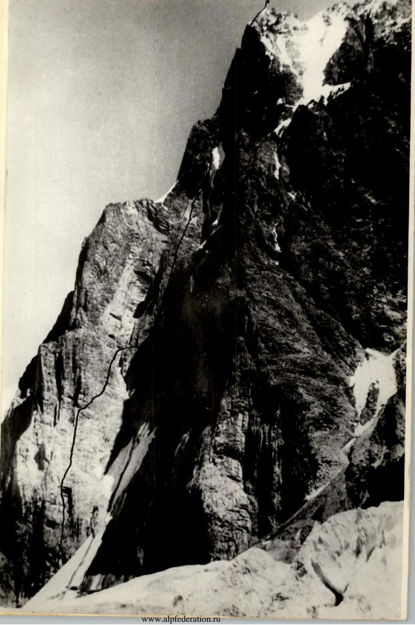
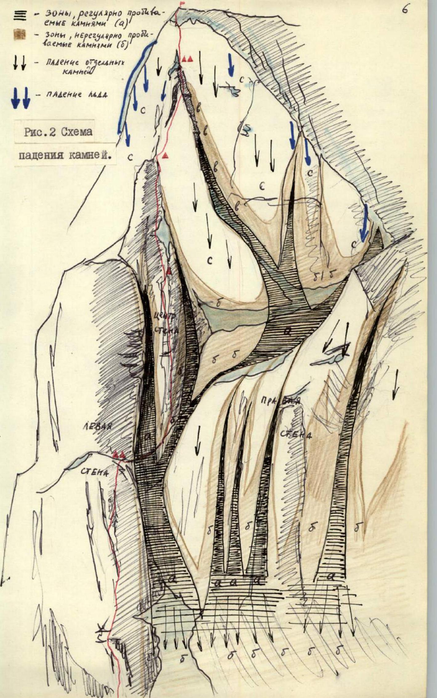
Bastilia Peak (5432 m) is located in the Academy of Sciences range, in a spur bordering the Medvezhiy Glacier on the left (see map-scheme, Fig. 1). The northern and northwest walls of the peak face the Medvezhiy Glacier and tower like a powerful bastion over the flat part of the glacier by almost two kilometers. The northwest wall is a huge internal angle. The left wall of the angle is the wall of a powerful central counterfort. The right side of the angle consists of walls shifted relative to each other, separated by couloirs. In the center of the angle is a convex central wall (see Fig. 2).
The left wall is composed of soft yellow rocks. Many live stones. Gentle sections — shelves, slabs, holds — are covered with sand and gravel. The right wall is gray. Characteristic structure — vertical slabs, often very large but thin. These slabs and slab-like rocks often peel off and fall, causing powerful rockfalls that affect almost the entire right wall. The right wall is cut by couloirs. In some gentler areas, there is steep ice and ice with snow. Under overhangs and on ledges, there are snow drifts and icicles.
The wall is gloomy, lit by the sun in the afternoon, and the top of the wall is also lit in the morning. At this time, rockfalls are most active: snow and ice begin to melt, water flows through the couloirs, icicles thaw and fall, and snow slides down in small avalanches. Often, rockfalls are caused by snow falling from the western ridge, and stones hit a large part of the right wall.
By 1975, the peak had not been conquered. For the first time, it was climbed by a group led by Piskulov (Spartak Sports Society) via the western ridge (more precisely, west-southwest), who assessed this route as very challenging, category 5B.
The unique two-kilometer wall was photographed and caught the attention of climbers.
The problem is choosing a safe route on the wall. At first glance, such a path does not exist, and indeed, any path includes sections prone to rockfalls. However, the route chosen by the team is practically safe with careful development of movement tactics and correct timing of section passage (photos 1, 2).
Routes to the right of the chosen one are affected by rockfalls almost all the time, especially intensely in the afternoon, and do not have areas safe from rocks for bivouacking. To the left of the chosen path, along the counterfort, a logical and safe route can be laid, but technically it will be less intense and interesting than the one taken by the group.
The route via the northwest wall is characterized by great length (over 2 km) and steepness (over 70°). To reach possible bivouac sites and overcome sections prone to rockfalls in the afternoon, the group must cover significant distances in a limited time. Participants must have good rock climbing and physical preparation, move extremely attentively, taking into account the severe destruction of the terrain.
The route imposes special requirements on team members regarding preparation and tactical thinking, considering the increasing difficulty as altitude is gained (the most challenging sections are in the second half of the route) and the abundance of live stones even on sheer sections.
The ascent took place from July 16 to 23, and conclusions about rockfall danger on certain sections are consistent with this time and the usual level of snow cover on the routes. It is possible that by the end of August, the wall will change its regime due to snow and ice melting, but the main conclusions about rockfall paths and regularity will remain valid, although their frequency and intensity may decrease.
II. Brief description of ascent conditions in the Medvezhiy Glacier area
The Medvezhiy Glacier is located at an altitude of 3000–3500 m. Surrounding peaks mostly exceed 5 km, meaning routes here typically involve a large elevation gain, often starting with couloirs and relatively gentle rocky ridges. Bastilia Peak is an exception — here, a wall rises directly from the glacier. A characteristic feature of the routes is the severe destruction of the mountain terrain and frequent rockfalls. Lower parts of the routes are composed of very soft rocks, including conglomerates of sand and fragments of hard rocks, sandstones, etc.
Snow cover is stable but subject to active melting, couloirs are prone to avalanches, and frequent falls of cornices and thawing snow drifts occur, causing rockfalls on walls, as well as icicle falls. Ice is frozen in the morning and softens in the afternoon. Walls lit by the sun have streams running down them. In the morning and evening, crevices are filled with ice. Snow practically does not freeze, making movement on it difficult. Weather is mostly stable, but snowfalls occur. Weather deterioration usually lasts 3–4 days, followed by 5–7 days of sunny weather.
III. Team preparation and training outings
The team's preparation cycle is year-round. However, for this ascent, the team began special preparation in the autumn when photographs of the wall and materials from the Spartak Sports Society team's ascent were obtained, and it became clear that the route would impose strict requirements on physical and rock climbing preparation and team coordination.
The team was formed from qualified rock climbers. Team members annually participate in several rock climbing competitions and use preparation for and participation in these competitions in their training cycle. This year, team members participated in several competitions, including the Leningrad city championship. Special attention was given to preparing for performances in rope teams. In this discipline, team members became champions and prize-winners of the Leningrad city championship and the Leningrad city cup competitions (Stepanov N., Grachev A., Manoilov Yu., Vedernikov V.). The team twice — in autumn and spring — visited the Crimean mountains. A significant amount of work was done on the rocks of the Karelian Isthmus. Such preparation and team composition helped maintain a high pace of movement and achieve coordinated and clear work among participants during the ascent.
The team arrived at the "Vyssotnik" alpine camp on July 2, 1976. The first outing was made on July 5–6 to the northwest wall of Bastilia Peak. The goal was to familiarize themselves with the route in person, preliminarily choose a path, acclimate, conduct a training ascent, and set up an upper camp.
It became clear that a large part of the wall is affected by rockfalls. The first impression was that there was no path on the wall, everything was hit by rocks. After observation, an approximate ascent path was identified. Refining the route required more careful observation of the wall.
It was decided to make a second outing to refine the route and conduct another training ascent here, opposite Bastilia. During the first outing, they managed to approach the wall, examine the rock composition, which helped in choosing pitons and equipment.
In the upper reaches of the Medvezhiy Glacier, near the wall, three tents were set up — an upper camp.
The second outing was made from July 9 to 12. On July 9 and 10, observations of the wall were conducted, a scheme of rockfall patterns and wall regime was compiled. The ascent route and timing of section passage were refined. Twice they managed to approach the wall. The exit to the route was clarified, and the path along the glacier from the upper camp through the chaos of crevices was marked.
The team made a first ascent of an unnamed peak (5000 m, approximately category 4B), marking the descent via the Akademii Nauk pass to the Medvezhiy Glacier — part of the descent from Bastilia Peak (see Fig. 1). Another goal was to organize and test a communication channel between the upper camp on the Medvezhiy Glacier and the "Vyssotnik" alpine camp using a "Nedra" radio station. Communication was established.
IV. Results of wall observation and final route selection
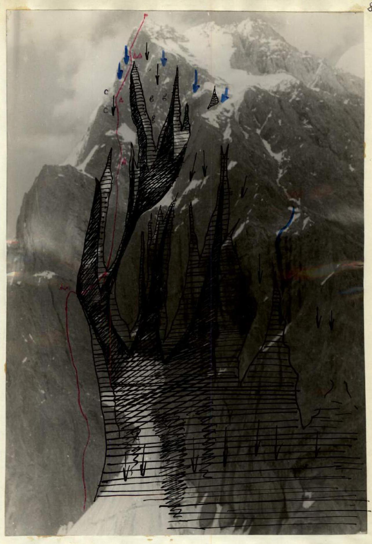
Observation revealed that the left part of the wall (see photo 1) is practically not affected by rockfalls. Rocks fall through the couloirs around the clock. Moreover, at night and in the morning until 13:00–14:00, they fall at intervals of 0.5–1 h, and from 13:00 to 21:00 at intervals of 10–15 min (sections "a"). At the same time, the lower right part of the wall and the lower part of the central wall are irregularly hit by rocks (sections "b"). The middle part of the right wall is affected by rocks only due to icicle falls, snow cornice collapses, slab delamination on the wall, and small avalanches from the western edge. The area of the "internal angle" is most dangerous (sections "v"). The upper part of the wall is dangerous only in the right part and to the left of the central counterfort (sections "c").
Rockfall-prone areas and rockfall paths are shown in photo 1 and Fig. 2.
Based on the observation results, a path was chosen:
- Start along the left part of the wall, bypassing the figurative snow field, exiting onto an osypnaya polka (scree shelf).
- From here, crossing the central couloir, exit onto the lower part of the central wall and continue up the center, along the convex part.
- Cross the couloir and exit onto the central wall in the first half of the day, before active rockfalls begin.
- Then continue up to the shoulder before the upper wall, to the left of the internal angle, and further up to the summit.
An alternative variant of passing along the outer part of the internal angle is possible but requires clarification. Later, this option was abandoned because both the outer part of the internal angle is affected by rocks and ice. Thus, the chosen path is practically safe if the couloir is crossed in the morning with necessary precautions (see Fig. 2, photos 1, 2).
V. Team composition as per application, assault group, and observation group
The team was registered for the USSR Championship in the following composition: team captain — Honored Master of Sports Viktor Aleksandrovich Solonnikov, participants — Master of Sports Grachev A.B., Master of Sports Borzov Yu.V., Candidate for Master of Sports Manoilov Yu.S., Candidate for Master of Sports GUTMAN A.R., Candidate for Master of Sports Stepanov N.V., Candidate for Master of Sports Vedernikov V.V., Candidate for Master of Sports Nazarov O. Team coach — Master of Sports Kheysin D.E.
The assault group consisted of six people: team captain — Viktor Aleksandrovich Solonnikov, participants: Andrey Borisovich Grachev, Yuri Vyacheslavovich Borzov, Yuri Semenovich Manoilov, Nikolai Vasilyevich Stepanov, Vladislav Valentinovich Vedernikov.
The assault group included experienced climbers who had made many joint ascents within USSR Championships, as well as the strongest young athletes who had completed their first category 6B routes in 1975. As a result, a very strong assault group was formed, where each participant could perform any task.
The observation group included Candidate for Master of Sports Nazarov O. as leader, Candidate for Master of Sports Pavilainen V.D., Candidate for Master of Sports Orlov B.K., Sofronov I.D. — 1st sports category, Novikova A. — 2nd sports category.
The group had:
- a spyglass with 30- and 60-fold magnification
- a "Vitalka" radio for communication with the team
- a "Nedra" radio for communication with the "Vyssotnik" alpine camp (see observation log).
VI. Tactics and plan for route passage
The plan was to complete the route in eight days, with one day for preliminary processing of the lower part of the route. The possibility of passing the route in seven days with an exit to the osypnaya polka on the first day was considered (see route sheet — declared variant). Bivouacs were planned:
- twice on the osypnaya polka (second day — processing the passage through the couloir and the lower part of the central wall)
- then a bivouac in the upper part of the central wall, on the second ascent (twice)
- and before the final ascent (see photo 2 and route sheet).
The route was completed by the team in seven travel days and one processing day. Bivouac locations corresponded to the initially chosen ones. Twice, in the process of the ascent, the same location was used for bivouacking — on the osypnaya polka and before the upper ascent.
To fulfill the planned ascent, it was necessary to cover 600–700 m of the route on the first and third days, and over 400 m after the second ascent. Covering such long stretches on challenging terrain is only possible with preliminary processing of significant sections and maintaining a high pace of movement. The exit to the osypnaya polka after processing was justified by the absence of intermediate bivouac sites. During processing, it was necessary to cover 350 m, i.e., hang all available ropes, rep cord, and an additional 90 m, which was accomplished.
The exit to the upper part of the central wall was necessary because the lower part of this section (the couloir and the lower central wall) is actively hit by rocks in the afternoon. Processing was also applied here: 240 m of rope and rep cord were hung.
The wall after the second ascent consists of sheer cliffs, and there is no possibility to organize even a sitting bivouac until a small shoulder before the upper wall. Therefore, processing was applied again, allowing the team to cover over 400 m in a day.
Familiarity with the wall during reconnaissance outings allowed the conclusion that there would be a danger of rockfall from the preceding climber on a significant part of the route. Therefore, special attention was given to choosing the path and securing points for ropes (movement as much as possible on a half-traverse, securing ropes under overhangs and нависающими скалами), as well as careful and attentive movement of participants.
It was clear that in most challenging locations, due to rockfall danger, it would be necessary to abandon pulling up backpacks, thus minimizing their weight. Equipment and supplies were selected such that the weight of each of the five backpacks did not exceed 8 kg when moving along the route at the beginning of the ascent. The first climber went through the entire route without a backpack and mostly in galoshes. On processed sections, part of the load was carried to the end of the processed section on the processing day, and then, at the start of movement, the weight was distributed among all six, allowing them to move along the ropes without pulling up backpacks.
Such movement was facilitated by training with weights during the preparatory period (practicing movement on ropes with a 6–8 kg backpack).
A system for changing the lead climber was developed, made possible by the even composition of participants. Options for movement on rockfall-prone sections were considered, where it is necessary to cover significant distances individually.
Since processing the passage through the couloir, the exit under the second ascent, and onto the last upper wall required work on ice, when approaching these sections, the second climber carried crampons and, if necessary, took the lead.
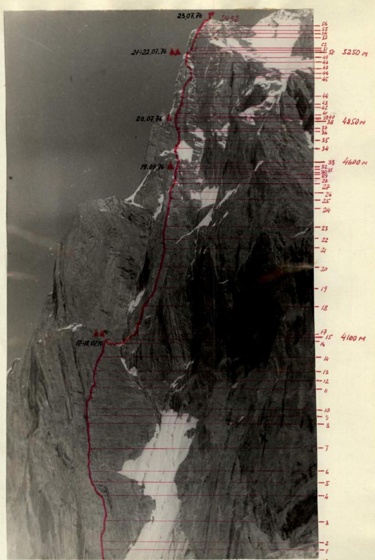
Photo 3. Section of the ascent route.
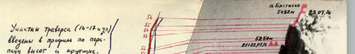
Photo 4. Profile of the ascent route. All measures regarding movement order, participant interaction, and the planned ascent were largely executed.
VII. Description of the ascent by days
First day. July 15, 1976
At 10:00, the team left the "Vyssotnik" alpine camp in the following composition: Solonnikov V.A., Grachev A.B., Borzov Yu.V., Manoilov Yu.S., Stepanov N.V., Vedernikov V.V., and observers Sofronov I.D. and Novikova L. At 14:00, the group arrived at the upper camp. The rest of the day was spent checking equipment and observing the route through a spyglass.
During training outings, everyone began to get accustomed to the wall, but it still somewhat overwhelmed with its gloom and grandiose scale, and it "worked" almost all the time. It should be noted that over the past two weeks, the wall had thawed somewhat, and the intensity of rockfalls decreased. Now we have a spyglass, and we double-check if the chosen path is safe, examine bivouac sites, and key points on the route — the central wall and upper ascents. Route sections are shown in photo 3 and profile snapshot photo 4.
The central wall appears very smooth, but the upper walls look particularly challenging — sheer and without much micro-relief. They appear monolithic, but we already know that we will face very unpleasant climbing on semi-live blocks and slabs. In reality, it turned out that even on sheer rocks, the rock is very weak, and climbing is extremely tense.
A group of our comrades is climbing along the western ridge (category 5B). It is led by a member of our team, O. Nazarov. After descending, he will lead the observation group. We will be able to get advice on descending from the summit via radio from the group climbing the ridge in two days.
Grachev A., Manoilov Yu., Stepanov N. checked the approach under the wall again. Tomorrow, in this composition, they will start processing the wall. The lower part of the wall is shown in Fig. 3 and photo 6.
In the evening, we check communication with the "Vyssotnik" alpine camp — the connection is excellent. An antenna is constantly stretched 20 m from the tents. The "Nedra" radio is connected to it. The wall looks great in the evening light.
Sолонников В. reminds the main tasks for tomorrow for the processing group:
- Cover 300–350 m and hang ropes.
- When choosing a path, monitor the order of movement and be very attentive.
- Stick to the planned path as much as possible and avoid deviating to the right to avoid entering the rockfall zone.
- Move as much as possible on a half-traverse (as planned from below) to avoid being directly above each other.
- Secure ropes in areas protected from rocks.
Everyone goes to bed early.
Second day. July 16, 1976. Route processing
At 7:00, the group consisting of Grachev A., Manoilov Yu., Stepanov N. heads out for processing and begins laying the path on the wall at 8:00. This path is challenging from the start: an inclined internal angle with many live stones runs along the sheer face (R0–R1, photo 10, Fig. 3). All three are wearing galoshes. The first, Grachev A., moves very carefully but fairly quickly.
- Upward to the right is a sheer internal angle with huge blocks barely holding in place, slightly overhanging. It is necessary to carefully bypass them along the sheer face (R1–R2).
- Further on, there is a more gentle section: slabs, but everything is covered with sand and gravel, and the rock is weak, making climbing unpleasant and tense (R2–R3).
- Again, there are steeper rocks. Movement is directed towards a powerful overhang. All the time, it is necessary to move through internal angles (R3–R4).
Such relief creates an increased danger when rocks fall, but fortunately, steep and overhanging sections are encountered, providing cover, and rocks often fly past. There are no spontaneous rockfalls — all stones fall far to the right along the couloir and ricochet into the zone about 20 m from the route — but there is a constant danger of dislodging rocks onto each other; participants must be extremely attentive. The guys quickly take turns working as the lead climber.
By 13:00, they have covered 200 m and approached a huge overhang (Fig. 3, R4–R5). After several attempts, they manage to bypass the overhang on the left along a sheer rock face (R4–R5). Climbing is very challenging, with few holds, and it is necessary to use ladders to pass sheer sections.
Further on, the rocks are heavily destroyed but still quite steep, although it is possible to move cautiously using free climbing (R5–R6). The next sheer belt is approached by covered sections.
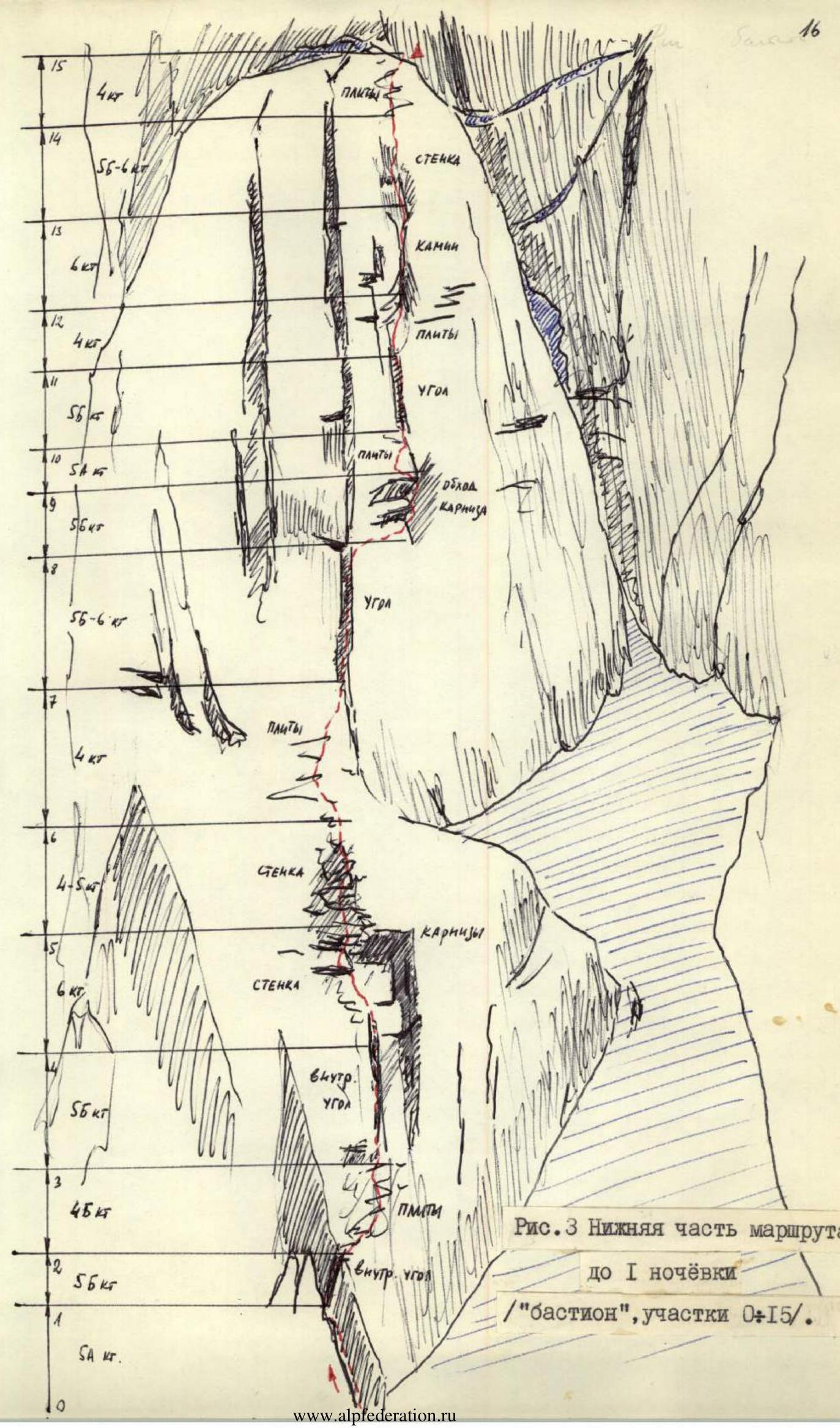
Fig. 3. Lower part of the route — slabs covered with sand. Initially, an intermediate bivouac was planned here, but there is practically no space for a bivouac, so it was decided that on the first day of the ascent, the team would pass the processed sections and attempt to reach the polka. This is another 300–350 m. All ropes are hung, along with rep cord and an additional 90 m of extra rope. It's already 16:00; it's time to return. At the last rope's securing point, a hammer, remaining pitons and carabiners, and a canister of gasoline are left. The processing team returns to camp by 19:00.
The task for the first day is accomplished. Tomorrow will be a challenging day — we need to reach the polka. The guys are tired but satisfied: the climbing is diverse and challenging, and there are still many "live" stones, and the rock, as expected, is not strong. The path is objectively safe — all rockfalls are to the right of the route. We report our progress via radio to the camp.
We learn that O. Nazarov's group has reached the summit. They will descend tomorrow. It's a pity we won't meet them. Processing took 8 hours. 31 rock pitons were hammered.
The guys continue to discuss the route's character and what lies ahead. For tomorrow, we distribute the load among the six of us. It comes out to be 8 kg (including personal items). This means that practically everywhere, we can move with backpacks.
After the processed sections, Grachev A. will take the lead. At the end of the last processed rope, he will unload his rock bag — three bags, a tent, personal items, and part of the supplies will be removed. These bags will be secured to the last pitons (special loops are sewn to the bags), and the lead will continue without a backpack.
We review the main movement options again. Solonnikov V. reminds us:
- about rockfall danger
- the need to move extremely attentively
- strict adherence to commands.
We discuss challenging sections on the processed route and those yet to come — it's necessary to psychologically prepare participants: tomorrow will be a tough day.
Third day. July 17, 1976. (First day of ascent)
Wake-up at 4:00. At 5:00, we leave the camp and start moving along the route at 6:00. We're in a fighting mood, so everyone climbs quickly and clearly. We drop the lower rope (90 m) to the observers. After section R2–R3, everyone gathers together. This spot is well-protected, and further on, there's an internal angle with live stones. We'll pass this section one by one.
On section R4–R5, we still have to pull up backpacks. By 11:00, we've passed the processed sections. Ahead is a sheer internal angle (R7–R8, photo 12). The rock structure is unusual — sheer, flaking slab-like rocks, but Grachev A. manages to pass here without dislodging a single stone. Rocks are smooth, but cracks are found, and reliable pitons are hammered. Backpacks need to be pulled up.
Ahead are steep, overhanging blocks, but they can be bypassed "along the edge," using small holds (R8–R9). Further on, there are destroyed rocks; there are many "live" stones, but movement is directed left and upward, and stones fly past.
At 13:00, we start ascending a smooth internal angle (R10–R11, photo 13). Rocks are almost sheer (~80°), with a glacier below. The angle is 50 m long. Some pitons are used as hand and foot holds. Holds are not strong. Climbing is very tense and challenging.
Further on, there are steep slabs with sand and gravel; a traverse to the right is made (stones continue to fall to the side). The path goes through a narrow crevice — a chimney (photo 14). From above, there are icicles, water flows, and rocks overhang. There's a long delay here. Ladders are used. Backpacks need to be pulled up. Fortunately, they are moving aside, and there's practically no danger of dislodging stones onto participants.
It's already 15:00; rocks are lit by the sun, and water starts flowing intensely from above. Half an hour later, it's a stream. Backpacks and participants are half-soaked.
Above the chimney, there's a steep internal angle ending in a slightly overhanging wall (R13–R14). Stepanov N. carefully passes the angle and, using pitons as holds, starts ascending the wall. Rocks are wet; stones are often dislodged by the rope, but everyone is under cover, and stones fly past without hitting anyone.
Finally, we exit onto the osypnaya polka via slabs. 19:00. We manage to set up a tent fairly comfortably. We report down that everything is okay.
Today, we covered the processed sections and another 350 m of the route in 13 hours. 40 pitons were hammered. The work is challenging.
We learn that O. Nazarov's group has descended, and now our observers are O. Nazarov, V. Pavilainen, and B. Orlov.
We discuss tasks for tomorrow:
- In the morning, we process the passage through the couloir and the beginning of the central wall.
- The lower part of the central wall is the most technically challenging work.
- Borzov Yu., Vedernikov V., and Grachev A. will go on processing.
Today is the opening day of the Olympics. We decide to dedicate our ascent to the XXI Olympic Games.
We're all six in the tent, it's a bit cramped, but fatigue is evident, and around 21:00, after tossing and turning, everyone falls asleep.
Fourth day. July 18, 1976. (Second day of ascent)
Wake-up at 6:00. At 8:00, Borzov Yu., Grachev A., and Vedernikov V. head out for processing. The central wall is shown in Fig. 4.
Sолонников В., Степанов Н., and Манойлов Ю. continuously monitor the couloir and warn the processing team in case of rockfall. Rockfalls are rare at this time. If they occur, stones mostly come from the top, from the "throat" of the couloir, and warned participants manage to take cover under overhangs.
Actions:
- First, descend by rope into the couloir.
- Then traverse upward to the right along a steep, ice-covered, and snow-covered shelf (90 m) (photo 5, R16–R17).
- Ropes are secured under overhangs.
- Ice sections are traversed in crampons, with steps chopped out.
- Work is conducted extremely focused and quickly.
Finally, the couloir is crossed, and participants gather before the sheer beginning of the central wall (photo 6).
Further movement along the shelf is dangerous — there's another couloir to the right, and stones fall through it too (see photo 1). It's necessary to tackle the wall head-on (photo 6, 17, 18, R17–R18).
Climbing features:
- The wall is smooth.
- Small holds are covered with dust.
- Few cracks for pitons.
Grachev A. leads (photo 17). After 20 m of very challenging climbing, he manages to hammer a reliable piton, and 2 m later, a second one. This is the first control point.
Problems:
- Galoshes don't hold well.
- Slip on dust.
By 11:00, the wall is passed. A small bend, and the processing team finds themselves in a wide internal angle (photo 20).
Smooth monolithic rocks give way to live blocks. It's necessary to overcome a small overhang using pitons as holds (R18–R19). The processing team takes turns. A bit further to the right, monolithic rocks appear, but after 10–15 m, "live" blocks reappear, with many barely holding "live" stones. All ropes are used up. 13:00. 300 m covered in 8 hours.
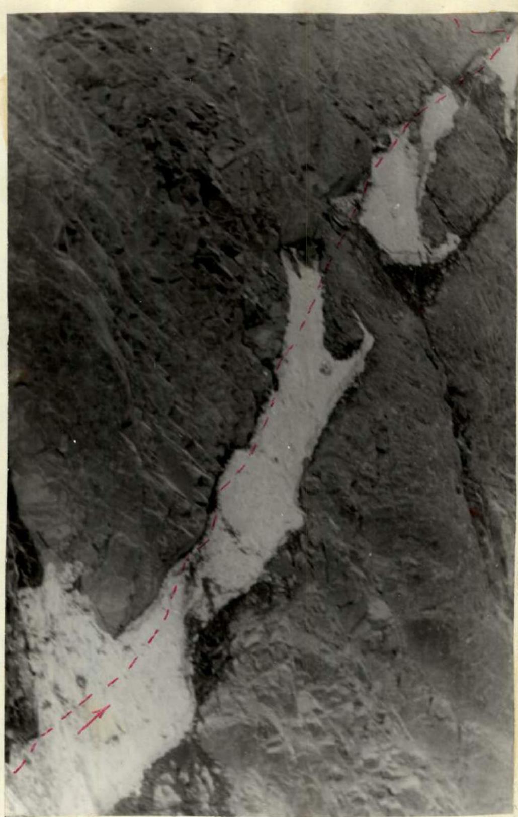
Photo 5. Crossing the couloir, approaching the central wall (R16–R17).

Photo 6. Lower part of the central wall. Participants are visible in the upper part of the wall (R17–R18). It's time to return. The guys quickly descend and, with careful observation, cross the couloir and return to the tent. 27 rock pitons are hammered on the hung ropes. Rockfalls are already intense in the couloir. Sometimes the lower part of the central wall is also hit, but the upper ropes are safe.
Tomorrow, we need to pass the processed sections by 12:00–13:00. The planned bivouac is in the upper part of the central wall (see photo 2). It's still about 300 m to it, so some rest today is welcome.
Again, we distribute the load among the six of us:
- The weight of gasoline and supplies has decreased slightly.
- The processing team left part of the load at the end of the processed ropes.
On the wall (R17–R18), we'll still need to pull up backpacks, but the wall is fairly monolithic, and possible stones will pass to the right. We discuss our progress via radio.
Fifth day. July 19, 1976. (Third day of ascent)
We wake up before dawn at 5:00, exit, and quickly cross the couloir. Pulling up backpacks and passing section R17–R18 takes over 15 hours. By 12:00, the processed sections are covered.
Along large-blocky rocks (R20–R21), we approach an overhang (R21–R22, photo 22). Ladders are used here. We attempt to pass this section with backpacks — it can be done with great difficulty. The first climber goes without a backpack and in galoshes. To the right, 10–15 m away along the couloir, stones are falling; our route, as expected, is safe.
Ahead are steep slabs (R22–R23). Again, many "live" stones — here, it's necessary to be very attentive. And again, an internal angle with "live" stones — 65 m (R23–R24). Here, we pass one by one. Others take cover under an overhang.
Along slabs, we approach a sheer wall. Pitons are used as holds. The section is challenging, but pulling up backpacks is too dangerous (R25–R26, photo 23).
Above, there's a small ledge, a snow drift. Here, a sitting bivouac can be organized, but the site is inconvenient. Borzov Yu. and Grachev A. go further without backpacks.
Along large-blocky rocks and snow-ice formations (R26–R27), we approach a smooth wall (R27–R28). The wall is wet, with practically no holds. With great difficulty, having hammered 3 pitons, Grachev A. passes 20 m — very few cracks for pitons.
Further on, 25 m up a sheer and even slightly overhanging internal angle-chimney (R28–R29). On sheer and overhanging sections, there are semi-live stones weakly attached to the rock base. Many fall down.
A small wall, and Borzov Yu. is under a snow overhang (R29–R30): crawling under it along a small inclined shelf, he again enters a chimney (R30–R31). Again, "live" stones and very challenging climbing.
Further on, there are steep slabs and a sheer wall, passed using ladders along two vertical cracks. Here, there's a steep ridge, snow-scalar.
Borzov descends, and everyone starts ascending by ropes, while Grachev builds a bivouac site. Sections R27–R33 are located one after another, and moving simultaneously on secured ropes is dangerous. It's necessary to pass sections one after another and pull up backpacks by rope.
By 20:00, everyone is at the top. Bivouac sites are inconvenient: two will sleep in a "harness" (photo 24), others will sit in a tent.
The challenging day is over. We report via radio that we've covered the processed sections and another 350 m of the route in 15 hours. 56 rock pitons were hammered.
Rest is tense, but everyone understands that the most challenging part is still ahead — the second ascent and upper wall. By distance, we've covered more than half, but there's still about 1 km of sheer and, apparently, most challenging rocks ahead.
Fig. 4. Central wall (sections R17–R33).
Sixth day. July 20, 1976. (Fourth day of ascent)
We exit at 7:00. Ahead are Stepanov N., Vedernikov V., and Manoilov Yu. We move along osypnye polki, slabs, approaching a sheer rock belt. Traverse under rocks on ice. Crampons are put on, and steps are chopped out (R34–R35). About 20 m along an ice-filled internal angle. The rock is very weak. Conglomerate sections are encountered — sand with embedded stones. Stones often fall from


