Ascent Passport
I. Ascent category — high-altitude and technical. II. Ascent area — Central Pamir.
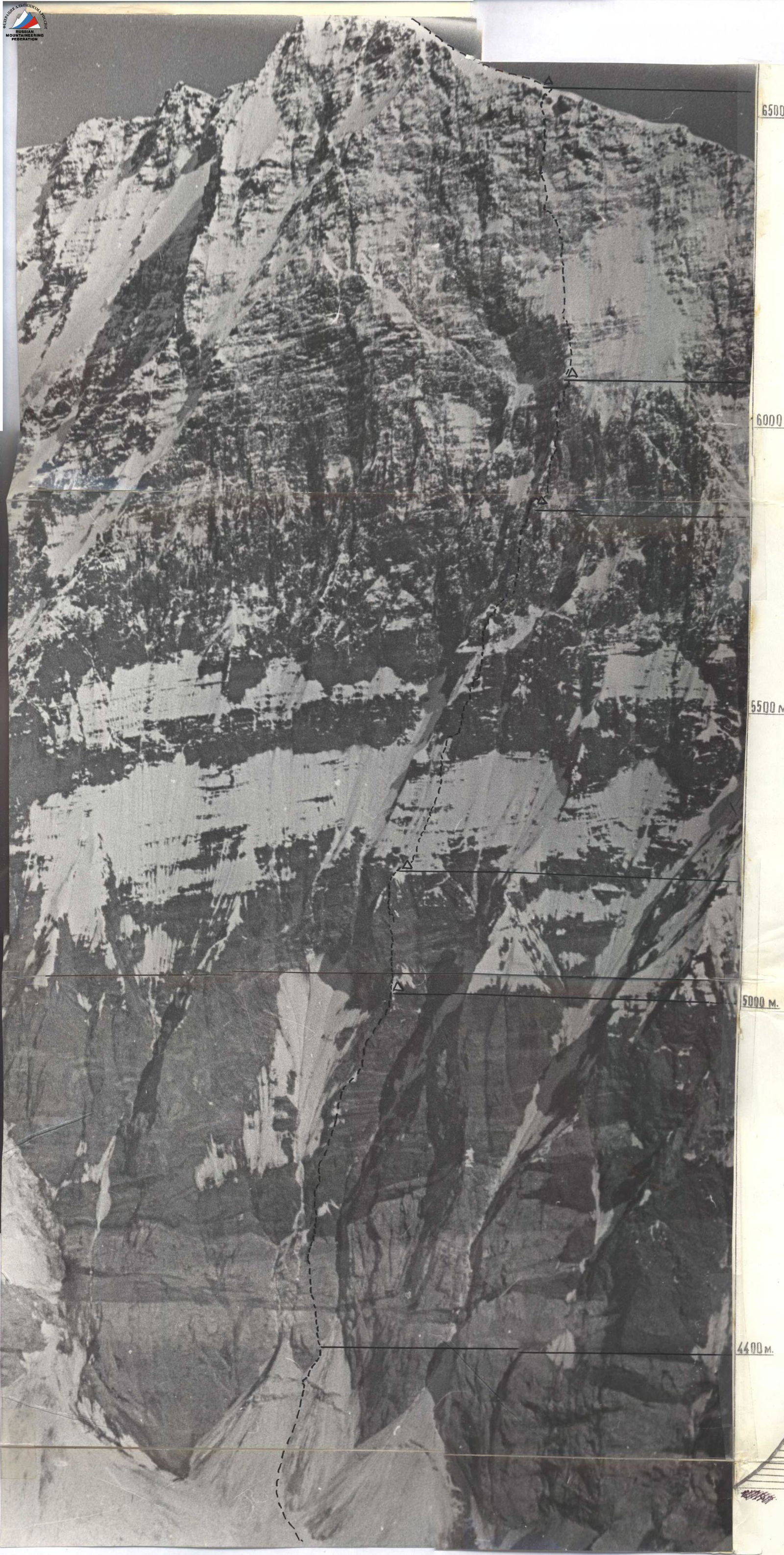
III. Southwest wall of Peak Akhmad-Donish (6666 m).
IV. Ascent characteristics: * height difference — 2300 m; * average steepness — 76°; * complex section length — 870 m. V. Number of pitons: rock — 364, ice — 5, bolted — 0.
VI. Total travel time — 62.5 hours. VII. Number of bivouacs — 5: 1. two very small platforms on rock shelves; 2. snow ridge; 3. two very small platforms made of snow; 4. platforms trodden on a steep snowfield; 5. firn platforms on the ridge.
VIII. Team from NarynGidroenergostroy and a special team of climbers. IX. Team leader: Efimov Sergey Borisovich, Master of Sports.
Team members:
- Lebedikhin Alexey Veniaminovich, Master of Sports
- Samoylin Mikhail Alekseyevich, Master of Sports
- Pushkarev Viktor Mikhailovich, Candidate for Master of Sports
- Sabirov Mamasali, Candidate for Master of Sports
- Popov Fedor Efimovich, Candidate for Master of Sports
- Kudashkin Yuri Valentinovich, Candidate for Master of Sports
X. Team coach: Honored Master of Sports, USSR coach Kuzmin Kirill Konstantinovich.
XI. Dates of departure and return:
- August 7 — processing the start of the wall;
- August 8 — departure on the route;
- August 14 — return to the base camp (3900 m) on the Bivachny Glacier.

Organizational and Tactical Plans
The object of the ascent — Peak Akhmad-Donish via the Southwest wall — was chosen back in 1972. In the autumn of 1973, Efimov revisited the area and took photographs of the wall from different angles. The photographs were carefully studied, and a variant for traversing the wall was planned. The only uncertainty was the middle section — crossing the large couloir, as the photographs could not provide a clear understanding of this section.
The path under the wall through the icefalls of the Voroshilov Glacier was also unclear. Based on this, a plan was developed for organizing the ascent on the Southwest wall of Peak Akhmad-Donish. It included going under the wall to find a passage through the glacier and observing the route, conducting an acclimatization ascent in the area of the Bivachny Glacier, followed by a training ascent on Peak Vasilyevsky (6300 m) via the West wall, and then proceeding to the Southwest wall of Peak Akhmad-Donish.
Prolonged and frequent snowfalls transformed the route. Additional study of the route was required, so the acclimatization ascent was replaced with an ascent to the slopes of Peak Ordzhonikidze with a night stay at an altitude of 5000 m to study the route in detail, its rockfall and avalanche danger. For this, a 60x spotting scope was used. What was discovered?
- The area that raised doubts when choosing the route from the photograph is indeed very dangerous, prone to rockfall and avalanches.
- The counterfort to the right, although steeper and more complex, is more favorably located.
- The route starting from it does not cross any couloirs on the wall.
It was decided to start the route from this counterfort.
The team's work scheme on the route was decided to remain the same, proven over the years and effective in complex high-altitude and technical ascents:
- fixing ropes by the leading climbers;
- daily rotation of the lead and the "sweeper" (four people can work equally quickly, easily, and reliably);
- traversing fixed ropes on sections of any difficulty, up to the most complex, with backpacks, which significantly accelerates the group's progress, reduces time spent at altitude, and thus increases the reliability of the ascent.
Great attention was paid to organizing nutrition. The use of lightweight homemade autoclaves (3.5 l — 500 g) allowed reducing the overall fuel consumption and using products such as:
- rice;
- millet;
- oats;
- fresh and dried meat.
Personal pouches with single servings issued each morning allowed for a mid-day snack without gathering everyone together, which was very difficult to do.
Route Description
The route begins at the center of the Southwest wall, not clearly expressed by a counterfort between two significantly protruding rock "claws." According to the photograph, the route was initially planned along the left "claw," but in the upper part of the "claw" — this rock bastion — there were no safe transitions to the wall. A huge couloir, which collects rocks and snow from the entire left part of the wall, intersects the proposed route.
Observing the wall revealed that the counterfort between the two "claws," although being more steep and technically complex, leads under a not clearly expressed outer angle in the center of the wall, practically to the summit. It is not intersected by couloirs, is safe from rockfall and avalanches, and is logical and beautiful, although more complex in the lower third of the route.
Thus, the route was chosen and approved by all team members. It is unknown if we can complete it, but it is the safest and most logical of the options that lead to the summit via the center of the wall.
August 7, 1974. Camp on the glacier (4300 m) under the wall of Peak Akhmad-Donish. In the morning, we are in the clouds. Visibility is 20–30 m. It is snowing, sometimes sleet. At 12:00, with improved visibility, Lebedikhin, Samoylin, and Sabirov, taking ropes and "hardware," go to process the start of the wall. Within an hour, they are working on a steep cone under the bergschrund, advancing under the rock "nose." To the right, 40 m away, avalanches continuously fall from the couloir. A strong vortex wind drives sleet across the entire wall, filling rock shelves and freezing fingers. The first quarter of the entire route (600 m) consists of steep rocks made of highly weathered yellow marble, resembling "ram's foreheads" with smooth shelves limited by the number of cracks with unstable slabs that rattle under hammer blows.
Progressing along the rocks begins with hammering a piton and hanging a ladder. Very steep! The smooth shelves are filled with wet snow and ice. The general direction is zigzagging vertically up along the "ram's foreheads" to the exit of black rocks. For five hours, they hang five "forty-meter" ropes, and the group descends to the glacier under the unceasing hurricane wind.
August 8, 1974. A sunny, calm morning. The bad weather that has been raging in the area for over a week has finally subsided. At 8:00, we depart from the moraine under the wall and begin ascending via the fixed ropes at 9:10. Oh, how they came in handy! The thawed snow has frozen. The rocks are covered with a thin layer of ice.
From the end of the processed fixed ropes, we move along a steep 30 m "forehead" to the black rocks, which, although steeper, have a more solid structure and more cracks. We bypass the black overhanging wall (20 m) from the left along an internal ice-filled corner. Climbing is very complex, but there are good cracks for hammering pitons. After advancing 5 m (80°) upwards, we have to hang a ladder as the rocks are completely covered in ice. Then another 10 m along the internal (85°) corner, and the Efimov—Lebedikhin team reaches the top of the black wall. Further, we have to move right and upwards along strongly destroyed rocks to avoid dropping stones on the lower teams. 20 meters — a section of medium difficulty that leads under a steep 15-meter "iron" (R4). To the right of it, an internal corner with a plug is formed. We move along it. Climbing is complex in wedges, but particularly unpleasant is the passage of the "plug" (to the right) along the black wall (2 m, 90°), which has many holds but is very unreliable. Having overcome the wall, we see that the rocks have slightly reduced their steepness but are still destroyed. Another 20 m of very attentive, cautious climbing (lower teams are moving), and again, yellow marble, and again slabs that need to be traversed on friction, and along them, water is already flowing. 100 meters of not very steep (65°) but technically challenging climbing on friction with a limited number of cracks lead to a small snowfield under the next wall. A 40-meter wall made of gray marble turns into a steep ridge that leads to a sheer 150-meter wall. Somewhere there, we will have to find a bivouac.
We start traversing the 40 m wall from left to right along a not clearly expressed internal corner. The color of the marble changes — the character does not. Steep, highly weathered "foreheads." The rocks are wet, with ice in many places. 40 m of very complex route (75°), and further, it feels like it should be easier. Another 20 meters of complex climbing (destroyed 2–3-meter walls) (R7) (80–90°), and the first team reaches the ridge (R8). 40 meters of rocks of medium difficulty lead under the base of a huge wall, gray and smooth (R8). At first glance, it is unclear how and where it can be traversed. 18:00. We start carving out platforms for tents in the rock. The Efimov—Samoylin team, wearing crampons, goes to try to process the first ropes. The sun sets behind the mountain. It has suddenly gotten cold.
The first 20 m along the continuation of the ridge are overcome fairly easily (R9). After another 20–25 m, a shelf is visible where insurance can be organized, but these 20 meters require 40 minutes to pass (R10). Great steepness is combined with the unreliability of holds. Pitons for insurance have to be doubled and tripled. Each one individually holds weakly. On the shelf, a reliable crack is finally found where a thick channel pin fits perfectly. The ropes are fixed. The team descends to the bivouac (19:30). Altitude 5000 m.
August 9, 1974. The weather is good. We depart at 8:30. The first rays of the sun illuminate the wall. Today, the leading team is Efimov—Lebedikhin. The "sweeper" team is Pushkarev—Sabirov. The first team ascends via the fixed ropes to the shelf, hangs backpacks there, and puts on crampons. Directly above their heads is an overhanging part of the wall; to the left upwards, a possible path is visible. Steepness is 85° (R11), smooth weathered marble (20 m). Using the smallest ledges and mainly friction from crampons, Efimov reaches the internal corner. To the left are smooth rocks; to the right is a slightly overhanging 3-meter wall but with cracks (R12). Using artificial points of support, he ascends to a slab with a steepness of 85° (R13). Another 10 m of extremely complex climbing leads under an overhanging cornice. Here, ropes are fixed, and further work continues (lifting backpacks). Under the cornice, a traverse of three meters to the left onto the wall and then vertically upwards along smoothed, crumbling ledges — extremely complex climbing of 25–30 m (R14). There are very few places to hammer pitons. Thin or thick channel pins and wedges work well. Further, the relief somewhat changes; the steepness decreases to 80°, and gaps appear, allowing climbing with hand and foot jamming (25 m) (R15). Climbing is very difficult (lifting backpacks). From here, slightly to the right and upwards along the ridge of the wall along snow-covered slopes (40 m) to its top — climbing of medium difficulty but very attentive. Many loose rocks. The wall ends with a horizontal snow ridge. A second bivouac is planned here. The location is indeed successful and safe. Further, a steep snow-ice slope follows, passing horizontally across almost the entire wall. While preparing platforms for tents, the Lebedikhin—Kudashkin—Popov team, taking all free ropes, goes to process the further route. The ice slope is covered with a 10 cm layer of slushy snow. Crampons are put on, and steps are trodden and cut for tomorrow's ascent. Insurance is through ice screws. The path is vertically upwards under the red wall (120 m). Having hung ropes, the team returns to the bivouac site at 19:00 (R18).
August 10, 1974. The weather is good. Departure at 7:30. The sun is still not out. It's cold. The leading team is Samoylin—Efimov; the "sweeper" team is Kudashkin—Popov.
The red wall (50 m) consists of steep, heavily snow-covered rocks ending in a shelf before a giant sheer wall, the so-called "seven" area (configuration of the snowfield resembling the number "7") (R19).
From the shelf, the path is visible, first to the left and upwards, then towards the "7." The rocks are black, strong, and all covered in ice. Vibram soles do not grip. Samoylin puts on vibram with metal studs and starts moving upwards, hammering off ice to reach cracks. 50 m of very complex climbing (85°) (R21). To the left of our route, a giant couloir begins, stretching practically to the summit. Rocks continuously fall along it. Having reached the snow-covered slabs (60°, 5 m) (R22), we move to the right and upwards towards an internal corner filled with greenish ice. To the right and left of it are smooth sheer walls. We have to go along it. 20 m of extremely complex climbing, 20 meters where ladders, ice screws, wooden wedges, and step-cutting were used (R23). The internal corner leads to steep destroyed rocks 40 m (R24) under a snowfield called the "seven." The exit to the snowfield is at the point where it abuts a sheer 20-meter wall (R25), above which a snow cornice overhangs. The wall is traversed straight on. 90°, 10 meters, and 10 meters, 80°. The rocks are strong; climbing, although complex, is pleasant. Loose snow lies on top. Sometimes standing on rock ledges, sometimes sinking waist-deep, literally digging a trench, Samoylin ascends (10 + 15 m) to the slabs (R26). Along them, moving to the left and upwards, we approach a new giant wall that leads under a snow "patch" at an altitude of 6000–6100 m. A half-kilometer wall with an average steepness of 80°. Somewhere in its middle part, a spot for bivouacs is visible. We should reach it today.
Movement begins along a vertical crack extending for 50 m (R26). After 10 m, Samoylin hangs a ladder, then a second. It starts to overhang slightly. The steepness increases to 85°, but the relief allows for free climbing (holds are strong, angled upwards), which is a great pleasure even for those behind. After 30 m, he reaches a small, narrow, and destroyed shelf that extends to the right (10 m). Then another 40 meters vertically upwards (in the middle part, a sheer internal corner is traversed) (4 m, 90°). Climbing is very complex. Insurance is organized standing on small ledges. There are no shelves. Further movement occurs to the left and upwards, closer to the large couloir. More than 100 meters have been traversed, and the steepness has not decreased. Another 40 meters to the left and upwards towards the couloir, along which rocks continuously rumble, and then the steepness decreases to 75°. Another 40 m of complex climbing leads (R29) under a smooth yellow 30-meter "iron," at the top of which snow is visible. Two more "irons" are visible behind it. The first "iron" is bypassed from the left along an internal corner. The rocks are filled with ice. Steps have to be cut. Climbing is complex and unpleasant (40 m). The sun sets behind the slope. It has gotten sharply cold. A third bivouac is planned here. There are no places for tents on the first "iron." We move to the second. The internal corner disappears. We have to ascend directly along the left wall of the "iron." The rocks are snow-covered, with ice underneath. Steepness is 75° (20 m). Climbing is complex. From the top of the "iron," a steep snow ridge follows, abutting the third "iron." Fortunately, the snow is wet. We start cutting out and literally molding platforms from snow. Meanwhile, Efimov processes the third "iron" straight on. By 20:30, we climb into the tents. We worked very well today. Altitude 5750–5800 m.
August 11, 1974. Departure at 9:00. We leave a cairn with a note at the bivouac site. 200 m above us, we see a giant rock cornice. Behind it lies a "snow patch" — a vast snow field. After passing the third "iron," we approach a sheer wall (20 m, 90°) with strong holds (R33). The first 3 m are filled with ice. We have to use a hammer. For the convenience of those climbing with a load, a ladder is hung. Climbing is very complex. The next 40 m, the rocks "lie down" to 80°, as if giving a break before the overhanging rock feathers, between which snow lies, and in some places, ice glimmers.
The path is planned:
- along a shelf to the right (10 m) under the "feathers";
- along an internal corner that turns into a chimney with ice formed by the "feathers."
This section, 30 m long, 90–85° (R35), is one of the "keys" to the route. In the lower part, we had to clear snow to hammer pitons; at the top, ladders were hung due to ice in the chimney. Climbing is very complex, requiring significant physical effort (lifting backpacks). Emerging from the chimney, we found ourselves under the rock cornice we saw from below. To the left hangs a huge snow overhang. To the right, an exit upwards is visible along a slightly overhanging rock cornice: 8–10 m, 95° (R36). The exit under it is along rocks mixed with snow. The upper crust of snow does not support body weight, and the lead climber sinks chest-deep into the snow between rocks (15 m).
Having maximally lightened himself, Samoylin starts moving along the wall and, having hung a ladder in the upper part, overcomes the wall. Another 10 m, and we are on a large snowfield (lifting backpacks). To the left, 20 meters away, a snow ridge is visible. We start making platforms for tents there.
30 m from this location, a rock strip begins with a steepness of 75°, extending 60 m (R38). Pushkarev, Efimov, and Sabirov go to process this section. 30 m of snow requires enormous effort to overcome. The slushy snow sinks. The lead climber digs a trench, sometimes chest-deep.
The rocks are traversed vertically upwards. Climbing is of medium difficulty. Having hung three "forty-meter" ropes, the team returns to the tents (19:30). The wind is blowing; the weather is deteriorating.
August 12, 1974. The sun is not visible. Heavy cloud cover, wind. We depart at 8:00. The ropes are icy. The snow covering the rocks has frozen overnight, and the steps trodden the previous evening hold well. The rocks are vertical 3–5 m walls separated by snow-covered shelves. Climbing is complex. Pitons are hammered well; the rocks are of a черепичного horizontal structure.
Having passed the rocks, we exit onto a snowfield and move left upwards under the wall. 100 m, 65°. As we approach the wall, ice appears. We cut steps (20 m). A path is visible on the wall towards the large "tooth" on the ridge — the lead climbers, Lebedikhin and Popov, are working on it. Our path, after a short traverse to the left, goes straight up along sheer strong rocks towards the rock "tooth" on the ridge. The first rope is confidently traversed by Lebedikhin, overcoming a section (10 m) of steep (90°) heavily destroyed rocks in the upper part, hanging 4 ladders for the group's passage. The steepness has slightly decreased, but the amount of snow on the rocks has increased. Popov moves forward, digging a trench, sinking sometimes waist-deep into the increasingly loose snow with altitude, and slowly moves straight up towards the next wall. Two ropes of such snow climbing along rocks with insurance via rock pitons and changing the lead climber. Lebedikhin is ahead; it's lunchtime, but there are no significant shelves to gather even in half-groups. A complex traverse along a sheer rock (15 m), ascent along an internal corner, and a sheer wall allow overcoming another 35-meter black wall. The ridge is close; there are 2 ropes left to it, but snow filling the rocks does not allow movement. Loose and deep, sometimes waist-deep, it does not hold, and we have to dig a trench to find footholds and cracks for pitons. Everyone has already had lunch, and Efimov, упорно advancing forward, has traversed only half a rope. It is very difficult to move upwards at an altitude of 6500 m when the snow underfoot constantly slides down, and it's impossible to reach the rock in some places. The last rope. The sun has already hidden behind the summit. Lebedikhin moves forward. A sheer 8-meter wall and a snow ridge turning into a sheer 3-meter overhang on the East ridge. The snow still does not hold, but the goal is close; another 40 minutes, and having overcome the last vertical meters of this snow wall with great difficulty, the lead climber disappeared behind the ridge. By 19:30, the group is on the ridge. The summit is in fog, and visibility around the group is poor. The first normal bivouac, where it's possible to take a step or two from the tent.
August 13, 1974. Departure for the summit at 8:00. Below, a dense layer of clouds. We ascend along the ridge to the summit (6666 m) by 8:40. Descent along the East ridge.
TABLE OF MAIN CHARACTERISTICS OF THE ASCENT ROUTE
Ascent route — Southwest wall of Peak Akhmad-Donish (6666 m).
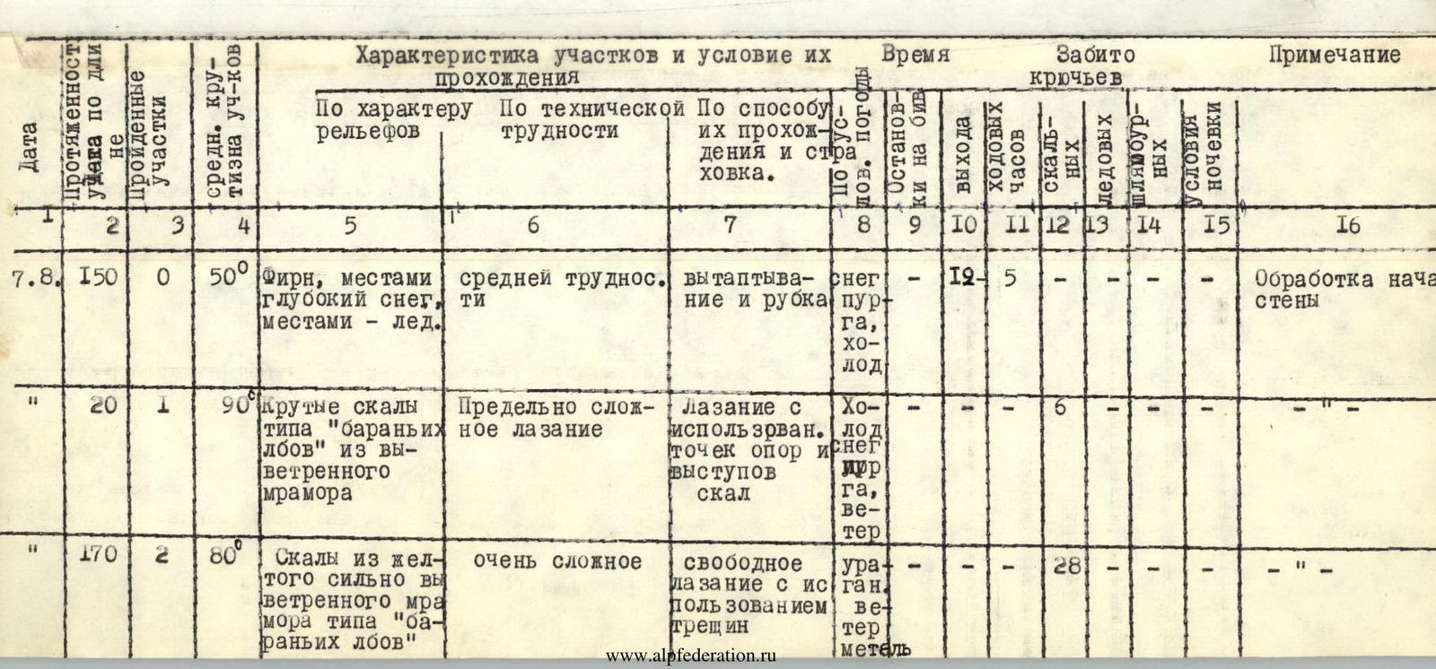
| Date | Section length along the route, m | Section number | Average steepness of sections, ° | Relief characteristic | Technical difficulty | Method of passage and insurance | Weather, conditions | Stops at bivouacs | Travel time | Rock pitons, pcs. | Ice pitons, pcs. | Bolted pitons, pcs. | Bivouac conditions | Note |
|---|---|---|---|---|---|---|---|---|---|---|---|---|---|---|
| August 7 | 150 | R0 | 50 | Firn, местами deep snow, местами — ice | medium difficulty | Treading and cutting steps | Snow, blizzard, cold | 12.5 | Processing the start of the wall | |||||
| 20 | R1 | 90 | Steep rocks like "ram's foreheads" made of weathered marble | extremely complex climbing | Climbing using points of support and rock ledges | Cold, snow, blizzard, wind | 6 | |||||||
| 170 | R2 | 80 | Rocks made of yellow, highly weathered marble like "ram's foreheads" | very complex | Free climbing using cracks | Hurricane wind, blizzard | 28 | |||||||
| August 8 | 15 | R3 | 85 | Internal corner with ice | very complex | Free climbing using a single two-step ladder | Sunny weather | 4 | Processing the start of the wall | |||||
| 5 | R4 | 85 | Internal corner with a plug | very complex | Free climbing | Sunny weather | 3 | |||||||
| 120 | R5 | 65 | Rocks like "ram's foreheads" | medium difficulty | Climbing on friction | Sunny weather | 17 | |||||||
| 60 | R6 | 75 | Wet rocks, местами covered with ice | very complex climbing | Climbing using natural relief | Sunny weather | 8 | |||||||
| 20 | R7 | 70 | 2–3-meter sheer walls | complex climbing | Sunny weather | 5 | ||||||||
| 40 | R8 | 75 | Steep, destroyed rocks | medium difficulty | Sunny weather | 19:30 | 10–30 | 8 | Very small platforms carved out of rock | |||||
| August 9 | 20 | R9 | 75 | Rocks of черепичного structure | medium difficulty | Sunny weather | 8:30 | 4 | ||||||
| 20 | R10 | 85 | Slabs with unreliable holds | very complex climbing | Sunny weather | 8 | ||||||||
| 20 | R11 | 85 | Smooth wall made of gray marble with few cracks | extremely complex climbing | Sunny weather | 4 | ||||||||
| 5 | R12 | 95 | Overhanging wall with cracks | extremely complex climbing | Climbing using natural relief | Sunny weather | 4 | |||||||
| 10 | R13 | 85 | Smooth slab | very complex | Sunny weather | 1 | ||||||||
| 30 | R14 | 90 | Bypassing the cornice along a sheer wall | extremely complex climbing | Sunny weather | 10 | ||||||||
| 25 | R15 | 85 | Vertical groove | very complex | Sunny weather | 8 | ||||||||
| 40 | R16 | 75 | Snow-covered rocks | medium difficulty | Sunny weather | 10 | ||||||||
| 20 | R17 | 30 | Snow ridge | 1 cat. sl. | Sunny weather | 19:00 | 10.5 | Snow platforms | Included in travel time is the time processing the start of the snow | |||||
| 120 | R18 | 60 | Snow-ice slope | medium difficulty but heavy | Treading and cutting steps with insurance via ice screws | No sun, cold | 7:30 | 3 | 5 | |||||
| 30 | R19 | 75 | Red snow-covered wall | complex climbing using natural relief | Climbing using natural relief | No sun, cold | 6 | |||||||
| August 10 | 20 | R20 | 65 | Snow wall with an exit onto rocks | computational difficulty | Cutting steps from firn | No sun, cold | 3 | ||||||
| 60 | R21 | 85 | Strong, steep rocks covered in ice | very complex climbing | Climbing using ledges and artificial points of support | No sun, cold | 17 | |||||||
| 5 | R22 | 65 | Heavily snow-covered slabs | complex climbing | Hook insurance | Sunny weather | 1 | |||||||
| 20 | R23 | 85 | Internal corner with ice accretion | extremely complex climbing | Climbing using ledges and artificial points of support | Sunny weather | 10 | |||||||
| 40 | R24 | 70 | Steep, destroyed rocks | complex climbing | Free climbing, hook insurance | Sunny weather | 10 | |||||||
| 20 | R25 | 85 | Sheer wall with strong holds | very complex climbing | Climbing using ledges, hook insurance | No sun, cold | 7 | |||||||
| 30 | R26 | 85 | Wall with a long vertical crack | very complex climbing | Climbing using natural relief and artificial points of support | Sun, light wind | 7 | |||||||
| 45 | R27 | 85 | 10 m traverse along a shelf, then upwards through a sheer internal corner — 4 m | very complex climbing | Two two-step ladders were used | Sunny weather | 11 | |||||||
| 40 | R28 | 85 | Wall with good, strong ledges | complex climbing | Climbing using natural relief | Sun hidden behind the slope, cold | 10 | |||||||
| 40 | R29 | 80 | Not clearly expressed ridge, many loose rocks | complex and very attentive climbing | No sun, cold, wind | 8 | ||||||||
| 20 | R30 | 75 | Bypassing the 1st "iron" along an internal corner with ice | complex climbing | Climbing in wedges with step cutting | No sun, cold, wind | 6 | |||||||
| 20 | R31 | 80 | Exit along the wall onto a snowfield, many loose rocks | complex climbing | Climbing using natural relief | Getting dark, cold, wind | 20:30 | 13 | 7 | Platforms molded from snow | ||||
| 30 | R32 | 85 | Overcoming the "iron" straight on, many loose rocks | very complex climbing | Getting dark, cold, wind | 9:00 | 10 | |||||||
| August 11 | 20 | R33 | 90 | Sheer, strong rocks | extremely complex climbing | Climbing using natural relief | Sun, cold | 8 | ||||||
| 45 | R34 | 85 | Sheer, strong rocks with medium microrelief | very complex climbing | Sun, cold | 11 | ||||||||
| 40 | R34 | 85 | Large-block rocks forming a chimney, with ice in the chimney | extremely complex climbing | Two ladders and artificial points of support — wedges were used | Strong, cold wind | 15 | |||||||
| 20 | R35 | 90–95 | Sheer, steeply inclined walls overhanging in the upper part | extremely complex climbing | Two ladders were used | Wind | 9 | |||||||
| 30 | R37 | 60 | Snowfield made of loose, very deep snow | section of medium difficulty but requiring great physical effort | Trenching, hook insurance, rope on rock exit | Wind | 18:00 | 10.5 | 3 | Snow platforms | Included in travel time is the time processing 4 km section R38 | |||
| 45 | R38 | 80 | Wall composed of sheer 2–3-meter walls covered in snow | fairly complex climbing | Hook insurance | Sun has set, cold | 20:00 | 10 | ||||||
| August 12 | 80 | R39 | 60 | Snowfield with firn crust | 2 cat. sl. | Cutting steps, hook insurance on rock exits | Fog, light snow, cold | 6 | ||||||
| 20 | R40 | 60 | Ice covered with a thin layer of snow | medium difficulty | Cutting steps, hook insurance on rock exits | Fog, light snow, cold | 4 | |||||||
| 40 | R41 | 85 | Snow-covered wall composed of horizontal blocks | very difficult climbing | Using natural relief | Cold is rising, piercing wind | 10 | |||||||
| 45 | R42 | 75 | Sheer wall with snow-covered shelves | complex climbing | Clearing rocks from snow followed by advancement | Piercing wind | 10 | |||||||
| 30 | R43 | 60 | Very deep snow with rock feathers | heavy climbing | Trenching | Piercing wind | 5 | |||||||
| 40 | R44 | 85 | Internal corner composed of horizontal blocks | very complex climbing | Climbing in wedges, clearing holds from snow | Sleet, very cold, wind | 11 | Good platforms on the ridge | ||||||
| 60 | R45 | 70 |


