1987 RSFSR Alpine Championship
High-altitude Climbing Category
Ir. 576 p. 9 dated 6.10.87 2nd ascent of V. Smirnov route, 6th category of difficulty
PEAK AKHMAI DONISH 6666 m
The photo contains a report from Smirnov's institute, but it was not provided to the team. Recorded with counter-V.
Approved for the ascent of Peak Akhmad Donish via the South Face (№ 4.1.5 according to KTMGV) by the team from the Sverdlovsk Regional Sports Committee.
Second ascent.
Team Leader Gержа S.L.
Team Coach Lebedikhin A.V.
Addresses:
- 620000, Sverdlovsk, Malyshev St., bld. 60, Regional Sports Committee phone 51-39-31, Alpine Department — Krivonogova Galina Ivanovna
- 620000, Sverdlovsk, Syromolotova St., bld. 7, apt. 173 Lebedikhin Alexey V.
- 620028, Sverdlovsk, Frolova St., bld. 23, apt. 47 Gержа Sergey L.
Passport
- High-altitude category
- Central Pamir, l. Bivachny
- Peak Akhmad Donish via the South Face.
- 6th category of difficulty, second ascent
- Elevation gain: 2300 m, distance 2585 m, sections of 5–6 category of difficulty: 2142 m. Average steepness of the main part of the route 73°30′, including 6th category of difficulty: 80° (80 m), 85° (65 m), 90° (175 m), 95° (56 m).
- Pitons used:
| Rock | Boulder | Slings | Ice |
|---|---|---|---|
| 385 | 0 | 137 | 54 |
| 18 | 0 | 15 | 0 |
- Team's total hours: 77.5, and days: 7.5.
- Bivouacs: 1st — a flattened area on a snowy shelf 2–3 — a flattened area on a snowy ridge 4th — an area on a narrow snowy ridge 5th — carved into a slope covered with rime ice 6th — an area on a snowy shelf with rime ice 7th — flattened on a snowy shelf
All bivouacs were in a prone position.
- Team Leader: Gержа Sergey Lvovich — CMS Participants: Bruck Mikhail Alexandrovich — CMS Mikhailov Andrey Vladimirovich — CMS Fedorov Yuri Semenovich — CMS Mingalev Vladimir Nikolaevich — CMS Fedorov Vyacheslav Anatolyevich — CMS
- Coach: Lebedikhin Alexey V. — MCMS
- Departure: August 7, 1987 Summit: August 14, 1987 Return: August 15, 1987
- Organization: Sverdlovsk Regional Sports Committee.
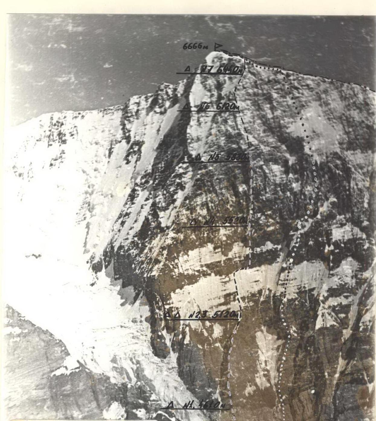
General Summit Photo
July 1974, 11:00. "Zenit" camera, "Mir-1B" lens, F=36 mm. Distance to the wall 3 km. Shooting point №1. Height of the shooting point 4600 m.
- route of V. Abalakov's team (Spartak) 1959
- route of S. Efimov's team (Naryngidroenergostroy) 1974
- route of V. Smirnov's team (Armed Forces of the USSR) 1975
- route of the Sverdlovsk Regional Sports Committee team 1987
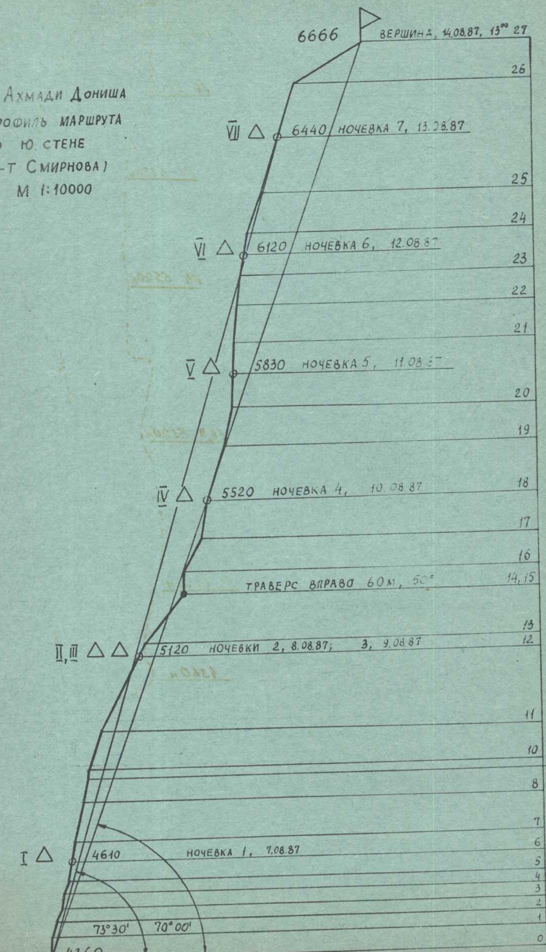
Route Profile
PEAK AKHMAI DONISHA ROUTE PROFILE Via SOUTH FACE (m-t SMIRNOVA) M 1:10000
- Summit, 14.08.87, 13:27
- 6440 m, Bivouac 7, 13.08.87
- 6120 m, Bivouac 6, 12.08.87
- 5830 m, Bivouac 5, 11.08.87
- 5520 m, Bivouac 4, 10.08.87
- 5120 m, Bivouacs 2, 8.08.87; 3, 9.08.87
- 4610 m, Bivouac 1, 7.08.87
- 4360 m
- Traverse right 60 m, 50°
- Sections: R0–R27
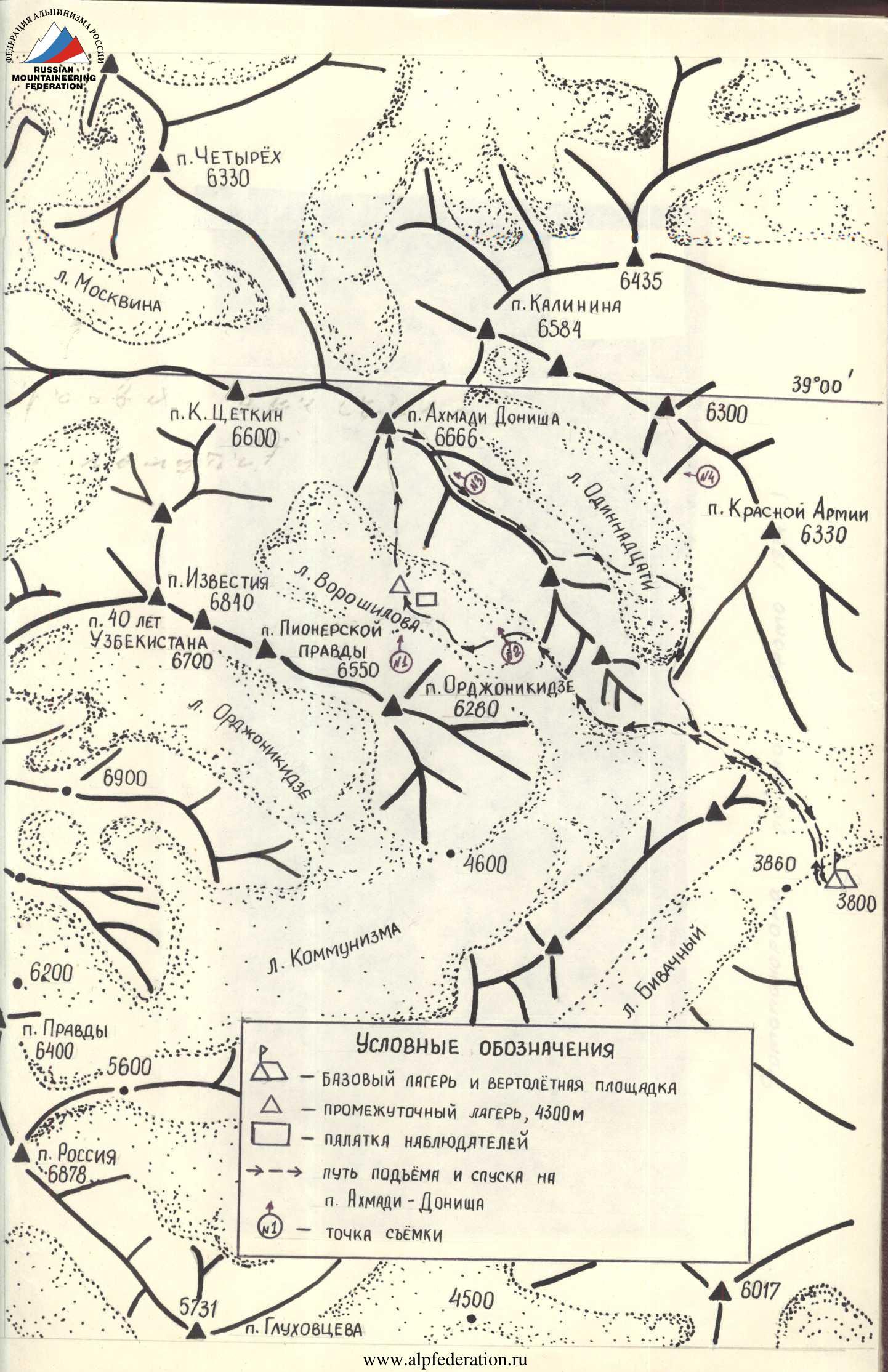
Brief Overview of the Ascent Area
Peak Akhmad Donish (6666 m) is a prominent peak in the Academy of Sciences range, adjacent to Peak Kalinin from the east and Peak Klara Zetkin from the west.
The approach to the south face of Akhmad Donish begins from the bivouac on the Bivachny Glacier, which is accessed by helicopter from Daraut Korgon. The path initially follows the Bivachny Glacier, then crosses the Kommunizm Glacier and leads to the Voroshilov Glacier.
The journey from the camps on the Bivachny Glacier takes 6–7 hours. It involves crossing the Bivachny Glacier, which has a relatively intact surface with easily avoidable seracs and crevasses. The glacier is open, with its surface largely covered in fine debris. The path is not considered particularly hazardous or challenging. The Kommunizm Glacier is similar. However, navigating the Voroshilov Glacier presents some challenges due to its uneven bed, resulting in a significant zone of icefall. Travelers must move along the left (orographically) edge of the glacier, pressing against the rocks. The steep ascent and risk of rockfall from both the overhanging rocks and seracs are notable hazards. In the middle section of the glacier, ropes were used. Further on, the glacier was crossed, avoiding the next icefall step, and the path continued along the right (orographic) edge of the glacier to its upper reaches. The upper part of the glacier has a relatively even surface, covered in snow, and the path is not particularly difficult until the start of the route. The approach to the route passes between two massive avalanche cones and then follows one of them along the rocks.
It's worth noting that the area around Peak Akhmad Donish is relatively rarely visited by climbers (teams: V.M. Abalakov (1959); P. Budanov (1966); S.B. Primov (1974); V. Bozhukov (1974), V.A. Smirnov (1975)), despite being near popular peaks like Peak OGPU, Peak Russia, and Peak Kommunizma. This is possibly due to the particularly challenging and labor-intensive approaches to the peak.
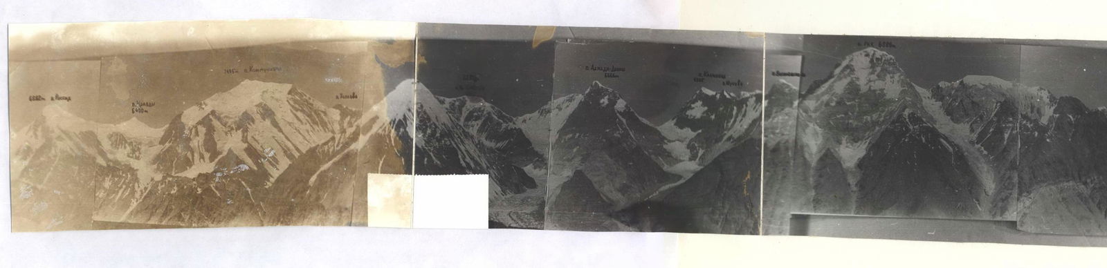
Panorama of the area (Photo 1974)
Pre-ascent Preparation
Throughout the year, the team regularly conducted training sessions for physical and technical preparation. Given the high-altitude nature of the championship, particular emphasis was placed on developing overall endurance (through skiing and running cross-country). All team members participated in alpine multi-discipline competitions, which included competitions and submission of standards for physical and technical preparation, as well as participation in overall physical training (OFT) competitions and rock climbing competitions.
Significant time was devoted to practicing belaying on rocks of 5–6 category of difficulty. Before departing for the mountains, the team studied the route, terrain characteristics, weather conditions, and geography of the area using the report from the first ascent by Smirnov's team in 1975 and consultations with members of S. Efimov's team, who completed the route on Akhmad Donish via the Southwest face in 1974.
The team also focused on selecting and preparing equipment. Before the start of the championship, a training camp was conducted, during which all team members ascended Peak Lenin to gain high-altitude acclimatization.
On August 2, before the ascent, a reconnaissance trip was made to the South Face of Akhmad Donish, on the Voroshilov Glacier. During this trip, the team reconnoitered the approach path from the base camp on the Bivachny Glacier, studied the route and its condition through direct observation, determined the daily pattern of rockfall, especially in the area of the snow-ice belt and couloir, and conducted photography of the route. An altimeter was used to measure the height at the base of the wall, and an angle measurer was used to assess specific sections of the route.
To ensure safety during the ascent, a rescue team was to be stationed in the base camp on the Bivachny Glacier. It was planned that part of the rescue team would be positioned under the route on the Voroshilov Glacier. Continuous observation of the group was to be maintained, and radio communication was to be established. The primary means of communication between the group and observers was to be via radio. The R-143 radio station was to ensure communication with the KSP (Control and Check Point) of the area.
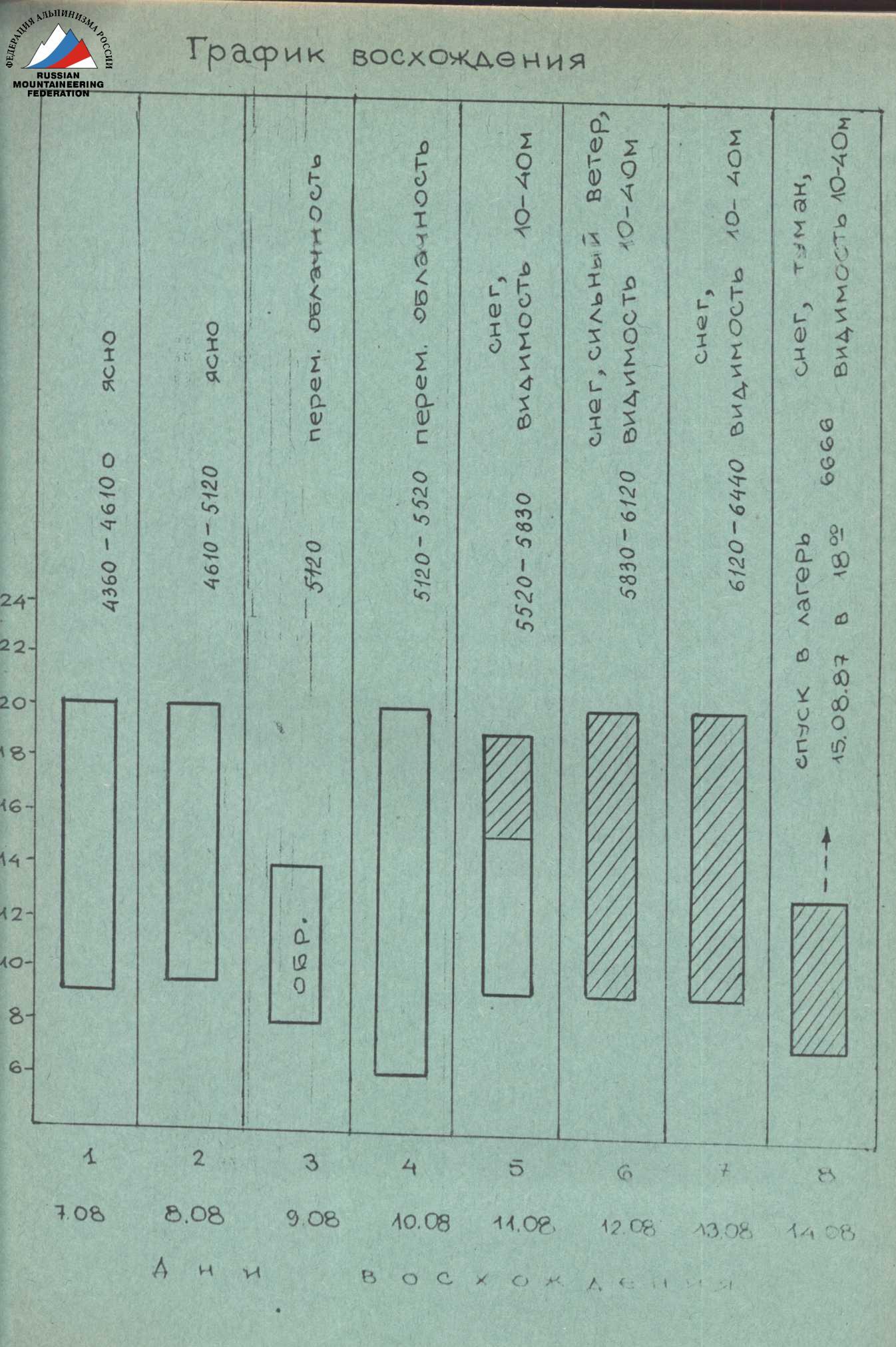
Ascent Schedule
Team's Tactical Actions
When developing the tactical plan for the ascent, the team referenced the time schedule of Smirnov's team, taking into account the heavy snow cover on the route. The plan was to complete the wall in six days, with one reserve day for weather deterioration or changes in route conditions. It was planned to:
- pass the "lapu" in two days;
- have the third bivouac above the snow-ice belt.
The initial plan was to start the route on August 5, but due to an accident in the Uzbekistan team and the need for transportation work, the departure was delayed until August 7.
The plan was to traverse the snow-ice slope in the morning, wearing crampons, without preliminary evening preparation. By evening, the snow-ice slope became rockfall-prone. The couloir in the upper part of the belt was also to be crossed in the morning—before the onset of rockfall.
Changes in snow conditions necessitated some adjustments to the previously outlined tactics. The snow did not set overnight, and in the morning, it did not hold weight, causing participants to sink. Traversing the snow-ice slope required significantly more time than anticipated, and a considerable amount of time was spent organizing reliable belays. Belaying through an ice axe proved ineffective; it was necessary to dig down to the ice (with snow depth reaching up to 1 m) and drill in ice screws.
In light of this, it was decided that:
- a double team would process the snow-ice slope in the morning;
- they would create footholds;
- and hang ropes.
The rest of the participants would remain at the tents on the ridge, safe from rockfall. The plan was to traverse the snow-ice slope and cross the couloir the following morning, which was carried out as planned.
The team's physical and technical preparedness was relatively uniform, allowing each participant to take turns leading on the route.
On August 7, A. Mikhailov led the first day on the route, completing sections R0–R6; on August 8, M. Bruck led (R7–R12); on August 9, S. Gержа led (R13–R14); on August 10, Yu. Fedorov led (R15–R18); on August 11, V. Mingalev led (R19–R21); on August 12, V. Fedorov led (R22–R24); on August 13, S. Gержа led (R25–R26); and on August 14, Yu. Fedorov led (R26–R27).
The first climber used a double rope, one of which was marked UIAL. The second rope was used for organizing belays. All others ascended via the fixed rope using two ascenders with additional upper or lower belays. Backpacks were not pulled but were carried on the climbers' backs, thanks to the use of two ascenders. On steep and overhanging sections, backpacks were attached to the climber's harness. The route was primarily ascended using free climbing.
During the first two days of traversing the "lapa," the first climber wore galoshes. In subsequent days, the first climber typically wore crampons. Throughout the ascent, there were no participant falls.
Throughout the ascent and during the descent, stable radio communication was maintained with observers. Not a single communication session was missed. The second half of the ascent occurred under unfavorable weather conditions:
- Continuous snowfall.
- Visibility was poor.
However, poor visibility did not cause delays in the ascent due to the logical nature of the route.
During the ascent, part of the rescue team was stationed under the route on the Voroshilov Glacier. The main rescue team was based in the base camp on the Bivachny Glacier, with which observers maintained stable radio communication.
| № | Rock | Slings | Ice screws | Ice | Route Diagram in UIAL Symbols | Category | Length, m | Steepness, ° |
|---|---|---|---|---|---|---|---|---|
| 27 | — | — | — | 6 |   | III– | 200 | 30° |
| 26 | 10 | 6 | — | 5 |  | V+ | 100 | 68° |
| 25 | 12 | 4 | — | 1 |  | V+ | 70 | 75° |
| 2 | — | — | — |  | V+ | 10 | 82° | |
| 15 | 6 | — | — |  | V+ | 95 | 73° | |
| 24 | 6 | 2 | — | 2 |  | V+ | 45 | 74° |
| 3 | — | — | — |  | V+ | 10 | 80° | |
| 4 | — | — | — |  | IV+ | 20 | 50° | |
| 5 | 2 | — | — |  | V+ | 30 | 75° | |
| 23 | 5 | 2 | — | 4 | V+ | 50 | 83° | |
| 10 | 4 | — | — | V+ | 60 | 78° | ||
| 22 | 3 | — | — | 4 | 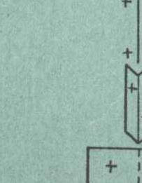 | V+ | 30 | 84° |
| 4 | 2 | — | — | V– | 30 | 80° | ||
| 5 | — | — | — | V– | 20 | 75° | ||
| 7 | 3 | — | — |  | VI A4 | 20 | 95° | |
| 21 | 6 | 2 | — | — | V+ | 35 | 80° | |
| 3 | — | — | — | VI | 10 | 95° | ||
| 3 | 5 | — | — | V+ | 30 | 80° | ||
| 5 | 3 | — | — |  | VI | 20 | 90° | |
| 6 | 3 | — | 3 |  | VI A3 | 20 | 90° | |
| 10 | 5 | — | — |  | V+ | 55 | 85° | |
| 4 | — | — | — |  | IV– | 8 | 45° | |
| 5 | 3 | — | — |  | VI A2 | 50 | 90° | |
| — | — | — | — | VI | 15 | 95° | ||
| — | — | — | — | VI A3 | 20 | 95° | ||
| 20 | 10 | — | — | — | V+A2 | 50 | 80° | |
| 6 | 1 | — | 3 | V+ | 10 | 65° | ||
| 5 | — | — | 12 | V+ | 40 | 80° | ||
| 5 | 4 | — | 2 | IV+ | 40 | 70° | ||
| 10 | 6 | — | — | IV+ | 20 | 65° | ||
| 7/2 | 3/2 | — | — | V+ | 40 | 75° | ||
| 19 | 5 | 1 | — | — | V– | 35 | 75° | |
| 2 | — | — | 2 | V– | 20 | 67° | ||
| 18 | 4 | 6 | — | — | V+ | 20 | 85° | |
| — | 2 | — | — | V– | 15 | 75° | ||
| 17 | 15 | 5 | — | — | V+ | 40 | 81° | |
| 16 | 6 | 1 | — | 3 | VI A2 | 15 | 85° | |
| 5 | — | — | 12 | V– | 20 | 67° | ||
| 15 | 5 | 4 | — | 2 | V+ | 20 | 85° | |
| 10 | 6 | — | — | V– | 70 | 68° | ||
| 14 | 7/2 | 3/2 | — | — | VI A2 | 15 | 85° | |
| 13 | 5 | 1 | — | — | V– | 20 | 67° | |
| 12 | 2 | — | — | 2 | V+ | 20 | 85° | |
| 11 | 4 | 6 | — | — | V– | 15 | 75° | |
| 10 | 8 | 4 | — | — | V+ | 40 | 81° | |
| 9 | 12 | 4 | — | — | V+ | 60 | 85° | |
| 8 | 9 | 5 | — | — | V+ | 45 | 76° | |
| 6 | 1 | — | 3 | V+ | 10 | 80° | ||
| 5 | — | — | 12 | V+ | 40 | 75° | ||
| 7 | 5 | 4 | — | 2 | V+ | 25 | 83° | |
| 10 | 6 | — | — | V– | 6 | 50° | ||
| 6 | 7/2 | 3/2 | — | — | VI A2 | 20 | 85° | |
| 5 | 5 | 1 | — | — | IV– | 5 | 55° | |
| 4 | 2 | — | — | 2 | VI A3 | 25 | 90° | |
| 3 | 4 | 6 | — | — | V+ | 5 | 50° | |
| 2 | 8 | 4 | — | — | VI | 25 | 80° | |
| 1 | 12 | 4 | — | — | V– | 30 | 70° |
Route Description by Sections
The entire route was ascended with the first climber establishing the route and the rest of the team following with backpacks, using two ascenders and having upper belays. The first climber ascended without a backpack on a double rope. The belays were hook belays.
Section 1. Features steep "ram's foreheads" with minimal cracks for belaying, the first climber wore galoshes, climbing was difficult.
Section 2. Slabs with narrow cracks; long, thin titanium pitons were used for belaying, climbing was difficult.
Section 3. Rocks composed of crumbling shale; titanium pitons ("carrots") were used for belaying, climbing was difficult and moderately difficult.
Section 4. An internal corner with solid rocks; climbing was difficult, and it was advantageous to use slings for belaying.
Section 5. A smoothed gutter; climbing was difficult.
Section 6. A wall composed of large blocks that easily detach.
Section 7. Platy rocks made of marbleized limestone, heavily weathered on the surface. The holds were smoothed. Sections of smoothed rocks resembling "ram's foreheads," sprinkled with sand, made climbing difficult. Long pitons were used.
Section 8. Characterized by a well-defined, dissected microrelief, but the rocks were steep. Climbing was hindered by the structure of the rocks, which consisted of easily detaching shale slabs. Belaying was done using pitons.
Section 9. Large, icy rocks with rime ice in the cracks. Belaying was done using pitons.
Section 10. A snowy internal corner with a cornice at the top; the rocks were monolithic. To establish belay points, it was necessary to clear the surface of snow and ice. Climbing was very difficult.
Section 11. A steep wall made of strong, porous rocks on the surface. A snowy cap overhung from the top. There were few cracks and holds. Climbing was very difficult, with the use of ladders.
Section 12. Rocks covered in snow. Climbing was moderately difficult, but establishing belay points was challenging. A vaguely defined ridge.
Section 13. Rocks of moderate difficulty. Climbing was complicated by the presence of ice and snow. Cramp-ons were used, and belaying was done using rock pitons.
Section 14. The snow-ice belt. The snow was deep and loose. Movement was hindered. Belaying was done using ice screws or, where rocks outcropped, rock pitons. There was a risk of rockfall in the second half of the day. The section was traversed in the morning, wearing crampons.
Section 15. A snowy-icy slope. Belaying was done on rock outcrops using pitons. A 60 m traverse to the right.
Section 16. A wall with monolithic rocks covered in rime ice. Climbing was very challenging. There was an overhang in the middle section. The first climber worked in crampons.
Section 17. A snowy-icy slope. Ice screws were used for belaying.
Section 18. "Tiled" rocks; climbing was very difficult, with piton belays. In the upper part, there were large, loose rocks, making climbing extremely difficult.
Section 19. Snowy, icy rocks. In the upper part, a destroyed, sharp rocky ridge with a snowy cap. In the end, a couloir with rime ice. Climbing was difficult. The section was traversed by the first climber wearing crampons.
Section 20. Large-block, monolithic rocks, steep and filled with snow. Climbing was very difficult. Belaying was done using pitons. The first ascent was made wearing crampons.
Section 21. A large wall with an overhang; rocks were large-block with ice, filled with snow, forming a chimney filled with ice and ending in a cornice; holds were not clearly defined. The ascent was complicated by the need to clear rocks for belaying. The first climber wore crampons. Belaying was done using pitons. Climbing was extremely challenging, with ladders used.
Section 22. Large-block rocks; a steep wall with solid, large holds but covered in snow. At the end of the нависающих скал — a snowy cornice. Climbing was difficult to very difficult. Belaying was done using pitons. The first climber wore crampons.
Section 23. An internal corner filled with snow, transitioning into a snowy-icy, steep ridge. Climbing was difficult. The first climber wore crampons.
Section 24. A rocky-icy couloir; rocks were snowy, large-block monoliths frozen in ice. Climbing was difficult, complicated by the need to clear snow and chop ice for belaying. Crampons were worn.
Section 25. A wall; monoliths; at the end of the section, a couloir. Rocks were heavily snowy. The snow was heavy and loose. Climbing was moderately difficult to difficult. Crampons were worn.
Section 26. Heavily snowy rocks; a steep wall transitioning into a rocky-icy couloir. Climbing was difficult. Crampons were worn. Belaying was done using pitons.
Section 27. The pre-summit ridge; snowy ascents; snow was deep; belaying was alternating: through an ice axe where ice was close, and through ice screws.
Equipment Table
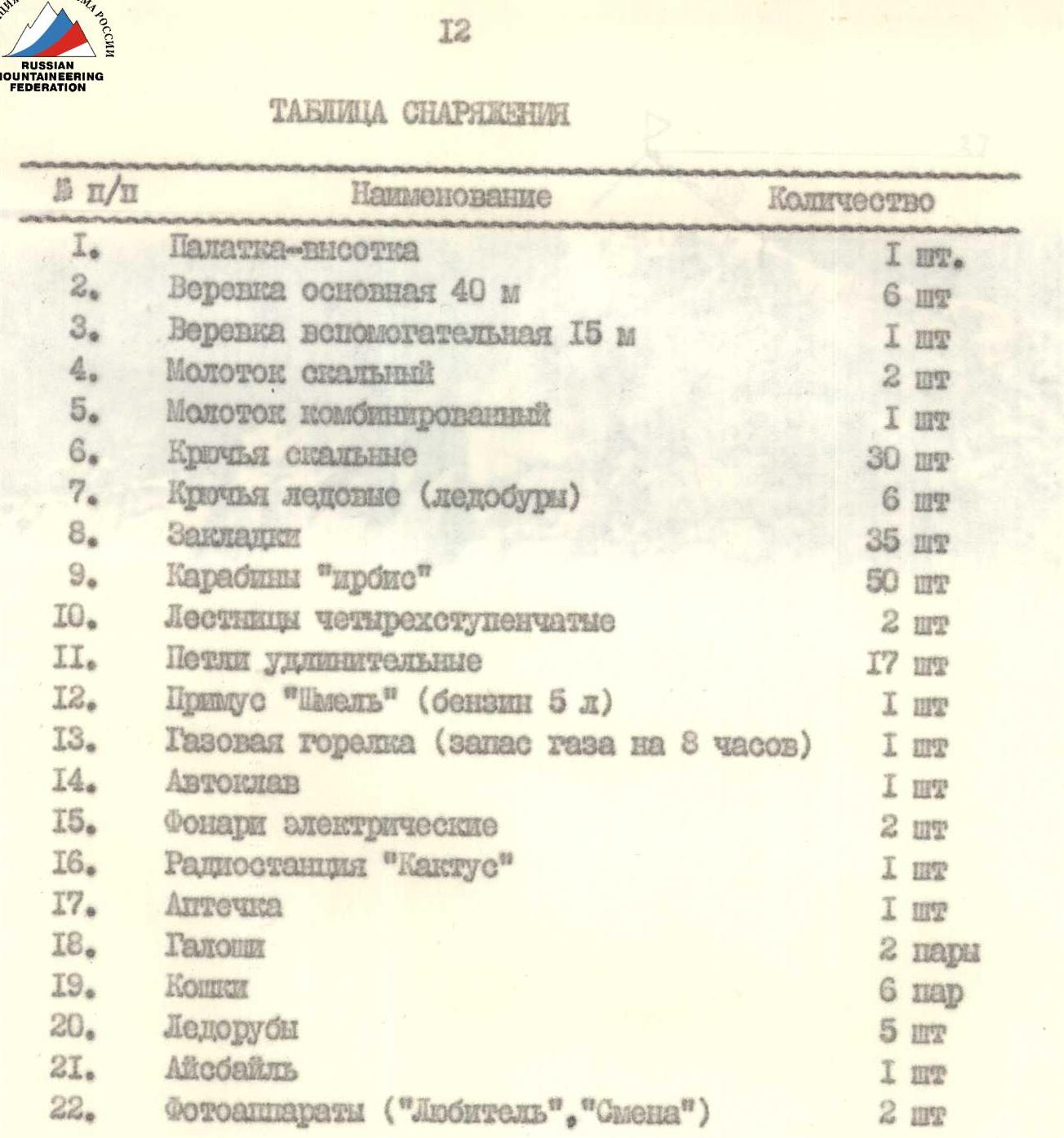
| № | Name | Quantity |
|---|---|---|
| 1. | High-altitude tent | 1 pc. |
| 2. | Main rope 40 m | 6 pcs. |
| 3. | Auxiliary rope 15 m | 1 pc. |
| 4. | Rock hammer | 2 pcs. |
| 5. | Combined hammer | 1 pc. |
| 6. | Rock pitons | 30 pcs. |
| 7. | Ice pitons (ice screws) | 6 pcs. |
| 8. | Slings | 35 pcs. |
| 9. | "Irbis" carabiners | 50 pcs. |
| 10. | Four-step ladders | 2 pcs. |
| 11. | Extension loops | 17 pcs. |
| 12. | "Shmel" stove (gasoline 5 l) | 1 pc. |
| 13. | Gas burner (gas supply for 8 h) | 1 pc. |
| 14. |


