Ascent Passport
Appendix No. 1
I. High-altitude and technical category 2. Ascent area — Central Pamir 3. Ascent route indicating peaks and their heights — Southwest wall of Peak "Ahmad Donish" (6666 m) 4. Ascent characteristics: height difference — 2300 m average steepness — 75° length of complex sections — 1340 m 5. Pitons driven: rock — 271 ice — 15 bolt — none 6. Number of climbing hours — 64.00 7. Number of nights and their characteristics — six, lying down, in good conditions 8. Team name — Armed Forces 9. Surname, name, patronymic of the team leader, participants, and their qualification:
- Smirnov Vadim Anatolyevich MS — captain
- Sedelnikov Viktor Nikolaevich MS — participant
- Akchurin Marat Khasanovich CMS — participant
- Timofeev Alexander Veniaminovich CMS — participant
- Shevchenko Nikolai Alekseevich CMS — participant
- Team coach — Honored Coach of Kaz. SSR Ilyinsky E.T. II. Dates of departure and return: July 29, 1975 – August 7, 1975 (July 29 — processing day)
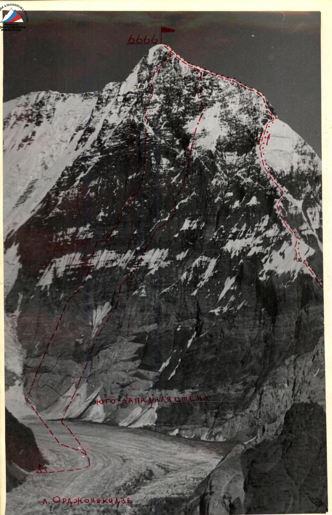 Peak Ahmad Donish. Southwest wall. Ascent routes.
- — route of V. Abalakov's group "Spartak", 1959
- — route of S. Eifimov's group "NarynGidroEnergoStroy", 1974
- — route of the USSR Armed Forces team, 1975
4. Description of the route passage
July 29
According to the tactical plan, this day was dedicated to processing the lower part of the route. This is due to the lack of suitable camping spots in the lower part of the route, and the unknown nature of the rocks, making it uncertain whether we could reach suitable camping spots without processing.
We started processing at 10:00. The weather was perfect: sunny and cloudless. The glacier was even, with practically no crevices. At 11:00, two teams:
- Smirnov — Shevchenko
- Timofeev — Akchurin began processing. Sedelnikov remained below to conduct additional observations of the route and take photographs.
The start of the route is a 100-meter snow slope with a 45° incline. We moved simultaneously. Upon reaching the designated start of the ascent, we tied in. The beginning of the route goes through "ram's foreheads" made of marbleized limestone. The surface layer is heavily destroyed. We passed a 60-meter wall with an 85° incline (section R0–R1). Climbing was difficult due to the destroyed surface layer, which crumbled under load. We had to wear galoshes. Then we moved 40 m along slabs with a 75° incline (section R1–R2). The rocks were solid, with few and very narrow cracks. Following the slabs, the rocks became gentler, and the structure changed to carbonaceous shale, which crumbled like tinder. The section was 35 m long, with a 60° incline (section R2–R3). Climbing was very unpleasant. Long, up to 25 cm, pitons worked well in the shale. We approached a 10-meter internal corner with an 80° incline, leading to a wall with an 85° incline and 30 m in length (section R3–R4). The rocks forming the corner and wall were solid, allowing for confident climbing. After passing the wall, we entered a rock gully 30 m long with a 70° incline (section R4–R5). The rocks in the gully were heavily smoothed, with few cracks. We used short pitons, but even they didn't fully embed. However, the rocks were solid, and climbing was reliable. The gully led to a small rock ridge, which brought us to a 25-meter wall with an 80° incline.
After overcoming the wall, we reached a relatively steep shelf with many loose rocks. We carefully crossed it and approached a нависающей wall (overhanging wall), which was passed on the right along a steep internal corner formed by a large split. The corner was 25 m long (section R5–R6). Climbing was very difficult with few reliable handholds.
Further movement continued along a steep talus shelf (50°), leading to slab-like rocks with an 85° incline and 20 m in length. We climbed vertically towards the split. The rocks were very complex, with smoothed handholds.
Then, along an inclined shelf formed by the split, we moved slightly left and reached the "ram's foreheads" again. We encountered marbleized limestone with an old, destroyed surface layer. We climbed vertically up 25 m (section R6–R7) and, after securing the last belay rope, began our descent. We were back on the glacier by 18:00.
July 30
We left the observation camp at 10:00. The weather remained sunny and windless.
Using the ropes hung the day before and with the help of jammers, we passed sections R0–R7. The Smirnov — Shevchenko team led the way. Climbing the "ram's foreheads" was challenging. We had to wear galoshes. The first climber went without a backpack. From the last belay rope's anchor point, we climbed 40 m upwards, slightly left towards an indistinctly marked shelf. The incline was 70–80°. Climbing was moderately difficult but tiring due to the lack of good handholds.
We reached the shelf, from which a 10-meter internal corner with an 80° incline led directly upwards. The corner was climbed with difficulty and brought us to rocks made of easily flaking shale plates. The impression was that the rock was peeling. This significantly hindered climbing. On such microrelief, finding a good crack for a piton was challenging. The section was 45 m long, with an average incline of 70–80° (section R7–R8). We traversed the plates slightly to the right, towards the edge of the "claw," which dropped off to the right with a wall. We approached a section of rocks wet from melting snow above. Even galoshes didn't provide good grip. We had to drive more pitons frequently. In the upper part, the wet rocks turned into a 15-meter sheer wall. It was made of fairly solid rocks with many good handholds. After passing it, we reached slightly gentler slab-like rocks 15 m long (section R8–R9). Climbing was moderately difficult. We moved directly upwards and reached a snow shoulder suitable for camping. While three team members prepared the campsite, the Sedelnikov — Timofeev team processed the route further.
The snow shoulder led to a steep wall, which was passed on the right along a 20-meter internal corner with an 80° incline (section R9–R10). The rocks were solid, with good handholds. In the upper part of the corner, a 0.5-meter corniche overhung, which was also climbed due to the numerous good handholds. We reached a ridge made of heavily destroyed rocks. We secured the rope and descended. It was 19:00. The night's camp was good and lying down. We reached an altitude of 4700 m.
July 31
We started at 9:00. The Akchurin — Timofeev team led. We passed the processed section. Then we traversed 20 m along the ridge with a 65° incline, leading to a 15-meter wall. The wall was steep, up to 80°, but made of solid rocks with good handholds. It was topped with a snowy, нависающая cap. Climbing was difficult. We had to cut through the cap.
From the cap, we traversed destroyed rocks to the right and upwards. The section was 70 m long, with an average incline of 60–70° (section R10–R11). The rocks were made of large, unstable blocks. Every minute, any block could fall off. Passing this section required great care.
The traverse led to a snowy slope with a 55–65° incline. The length was 30 m. We climbed directly up, reaching a rocky-snowy ridge with a 45° incline. The section was 10 m long (section R11–R12).
The ridge led us to a snow-ice belt. We chose a camping spot near the ridge. One team prepared the site while the other processed the route. From the ridge, it was clear that the stony couloir to our right, which we were about to cross, was being hit by falling stones. This confirmed our preliminary observations.
The snow-ice belt was about 160 m long, with an average incline of 50° (section R12–R13). In some places, snow turned to ice, requiring step cutting. We set up a control cairn at the lower part of the belt.
August 1, 1975
We left early at 6:30. We traversed the processed section quickly along the frozen snow. We approached the belt of black rocks and rapidly traversed the snowy-ice slope along the stony-ice gully. The team worked quickly and in harmony. The Smirnov — Shevchenko team led.
With difficult climbing and wearing galoshes, we overcame a 30-meter sheer wall of black rocks, transitioning into a 6-meter нависающий section covered with ice. Climbing was very difficult, requiring two ladders. We pulled up our backpacks.
Beyond the нависающий section lay a 15-meter sheer wall (section R14–R15), covered with ice. Climbing was challenging due to ice-filled cracks. We reached a narrow rock shelf and moved left along it, climbing rocks of moderate difficulty for 20 m. The rocks were partially covered with ice. Further, the rocks became gentler (65°) and turned into 25-meter smoothed rocks.
After overcoming rocks of moderate difficulty, we reached a 50-meter snowy-ice slope with a large incline and rock outcrops (section R15–R16). The snow was up to 10 cm thick. In some places, we had to cut steps as the snow was sliding and didn't hold.
The sun warmed the rocks, and stones began to fall. However, we were safe as we had exited the stony gully and approached the start of a steep контрфорс leading to the main part of the wall ("mirror").
The Seidelnikov — Akchurin team led. The rocks were steep, made of large, flaking blocks. Attempting to drive pitons caused blocks to break off. Only long (up to 25 cm) thin pitons were helpful.
We climbed vertically up a 55-meter wall with an 80° incline. After passing the wall, we reached a small shelf and moved right. The shelf's incline was 60°, and its length was 20 m. The shelf led us to a sheer wall 30 m long (section R16–R17). In the upper part, many loose rocks were dislodged by touch. We had to "clean" the rocks while standing on ladders.
The wall led us to a small shelf, from which a convenient internal corner, filled with water, led right and upwards. The corner's incline was 75°, and its length was 35 m. The rocks were solid, with many convenient handholds. The internal corner led us into a gully heading towards a rocky ridge with a stepped structure and snowy cornices. The rocks in the gully were covered with ice and snow. The incline was 70–80°, and the length was 40 m.
After cutting through the corniche, we reached a destroyed ridge. Movement along the ridge was hindered by its stepped structure. Therefore, we traversed it from left to right along a 20-meter section. The average incline of the traverse was 65°. Further movement along the ridge was practically impossible due to its stepped structure and нависающие snowy caps.
We decided to enter a steep (70°) rocky-ice gully located to the right between our ridge and the adjacent one (section R17–R18). At the top, where the ridges merged, we saw an exit onto a snowy pad adjacent to the main wall section, conditionally named "mirror." After overcoming the 40-meter gully with step cutting and cutting through a snowy corniche, we reached the snowy pad adjacent to the "mirror" of the wall. The day's plan was fulfilled. We prepared a campsite. We reached an altitude of 5500 m. It was 18:00. We built a control cairn at the start of the "mirror."
August 2
According to the tactical plan, this day was for processing the "mirror" of the wall. The Timofeev — Akchurin team started processing at 9:00. The weather was satisfactory, with occasional dense cloud cover and wind.
The rocks at the base of the wall were made of large blocks, with an 80° incline. We climbed vertically up 40 m. Climbing was difficult. We reached a smooth inclined slab with a 65° incline (10 m). We moved right and up along a crack. We approached an inclined internal corner. The corner was inclined to the right, with an 80° incline and 50 m in length (section R18–R19). Climbing was difficult but reliable due to monolithic rocks. Along the internal corner, we approached a 20-meter нависающая wall (95°). The rocks were monolithic. Climbing was challenging, but there were many reliable handholds. Despite this, we used ladders.
The wall led to a small sloping shelf. Here was a convenient spot for pulling up backpacks.
From the shelf, a нависающий internal corner led right and upwards, 15 m long. Climbing was difficult, with smoothed handholds. We used ladders three times. The corner led to a small shelf. After moving along it to the left, we approached a sheer wall. Choosing the most rational path, we overcame it along a weakly expressed 50-meter internal corner with a 90° incline. The rocks were solid, with good handholds on the corner's ledges. Climbing was difficult but reliable. In the upper part, the corner turned into a wide crevice with an 80–90° incline and 55 m in length, leading to a wide rocky shelf (8 m) with a 45° incline, covered with snow and loose rocks. From the shelf, we climbed directly up a 20-meter sheer wall made of solid brown rocks. In the upper part, a 0.5-meter corniche overhung. We used ladders to pass the corniche (section R19–R20). The wall led to a small inclined slab. The last rope was secured on the slab, completing the processing.
August 3
We left at 7:00. The weather was bad, with occasional snowfall. By 10:00, we had passed the processed ropes.
On the sheer section R19–R20, we had to climb using jammers and pull up our backpacks. Upon reaching the anchor point of the last belay rope, we climbed a 30-meter section of rocks made of large blocks. The incline was 80°. Climbing was difficult.
In the upper part of this section, a нависающая (overhanging) wall 10 m long with a 95° incline was made of solid rocks. We climbed it due to the many very good handholds. We pulled up our backpacks.
Following the wall were slab-like rocks made of very large blocks. The average incline was 75–85°, and the length was 35 m. Climbing was moderately difficult. Moving directly upwards along the slabs, we approached a 20-meter нависающий (overhanging) section of the wall (section R20–R21). It was topped with a snowy corniche. Climbing was very difficult. The most rational path was along a weakly expressed internal corner to the left and upwards. We used ladders and pulled up our backpacks.
After cutting through the corniche, we reached a snowy shelf. From there, we climbed to the right and upwards along rocks of moderate difficulty for 20 m (75°). Climbing was complicated by ice filling the cracks. Further, our path lay along an internal corner with an 80° incline and 80 m in length, leading to a weakly expressed контрфорс. Climbing along the corner was moderately difficult, with many well-defined handholds.
On the контрфорс, many "live" rocks were present. The rocks were partially covered with ice. The контрфорс was very steep (80°) (section R21–R22). After passing it, we reached heavily snow-covered rocks, partially covered with ice. The incline was 65–75°, and the length was 60 m. The snow was loose and didn't lie flat on the slopes, making passage very laborious. We traversed the snow-covered slope to the left towards a rocky-ice gully with a 75° incline. After cutting steps in its right part for 50 m, we reached a small snowy shoulder and began preparing the campsite (section R22–R23).
While one team prepared the site, the Smirnov — Timofeev team processed the next day's route.
The further ascent path was characterized by a general gentler relief.
Initially, we passed rocks heavily covered with snow. The incline was 70–80°, and the length was 30 m. Following this, there was a 65° section of rocks (20 m). The rocks were covered with loose snow throughout, presenting a significant challenge.
Along the snow-covered rocks, we directly approached a small (10 m) wall with an 80° incline. The rocks were light brown and large-block. Climbing was difficult.
After passing the wall, we overcame a heavily snow-covered rocky gully with an average incline of 75° and 45 m in length (section R23–R24), concluding the processing for the day. We reached an altitude of 6000 m.
August 4
We left at 6:30. The weather was overcast, with occasional snowfall. We passed the processed section, then coiled and dropped three ropes. We had four ropes left, sufficient for the remaining part of the route.
Further movement along snow-covered rocks with a 70–80° incline and 95 m in length continued, slightly left. The rocks led to a small (10 m) almost sheer wall.
Beyond the wall, the most convenient path lay along a 70-meter контрфорс made of large-block rocks.
After passing the контрфорс, we entered a rocky gully from the left. It was snow-covered, with rocks partially covered with ice. The incline was 70–80°, and the length was 100 m (section R24–R25).
The gully led to a ridge heading towards the V. Abalakov ridge. Upon exiting the gully, we built a control cairn. The ridge was heavily destroyed, with an average incline of 60–70° and 120 m in length. In the upper part, the ridge became steeper, up to 70°, with a length of 80 m. We moved alternately, with belays through pitons and выступы (rocky outcrops).
We reached the V. Abalakov ridge leading to the summit. The height was approximately 6550 m. The further path was straightforward, along snowy slopes with a circa 30° incline. We left our backpacks at the ridge exit and moved lightly towards the summit.
At 16:00, we reached the summit. The weather was very poor, with snowfall and strong winds.
From the summit tour, we retrieved a note left by V. Bozhukov's group in 1974, who had traversed Peaks "Kalinina" — "Kommunizma." We left our own note. We took photographs and quickly began our descent from the summit. By 17:00, we were back at our backpacks and started setting up our tent. We camped at an altitude of 6550 m.
August 5–6
Over two days, we descended along the V. Abalakov route (1959). The descent was challenging due to the steep ridge, numerous cornices overhanging on both sides, and many rocky "жандармы" (sentinels), requiring double-rope descents with rope pulls.
The descent was further complicated by the very hot weather, causing the snow on the ridge to become soggy and slide under our feet by 14:00. We camped halfway along the ridge. Upon reaching the ridge's lowest point, we began descending towards the "Одиннадцати" (Eleven) glacier. The descent was along "ram's foreheads" made of marbleized limestone, with multiple belay setups and rope pulls.
On the evening of August 6, having descended to the "Одиннадцати" glacier, we camped. On August 7, at 13:00, we arrived at the base camp.
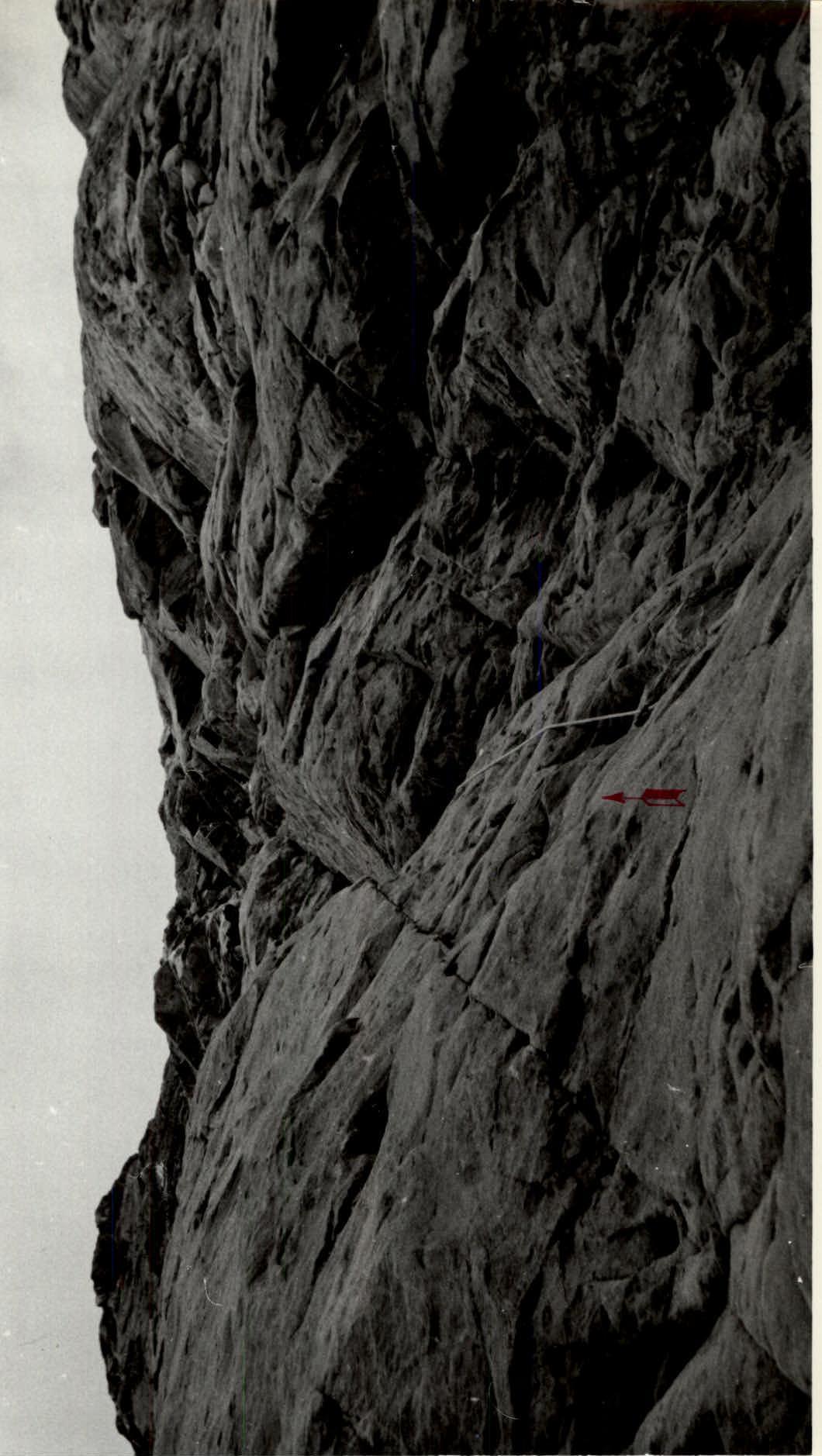 Section R0–R1.
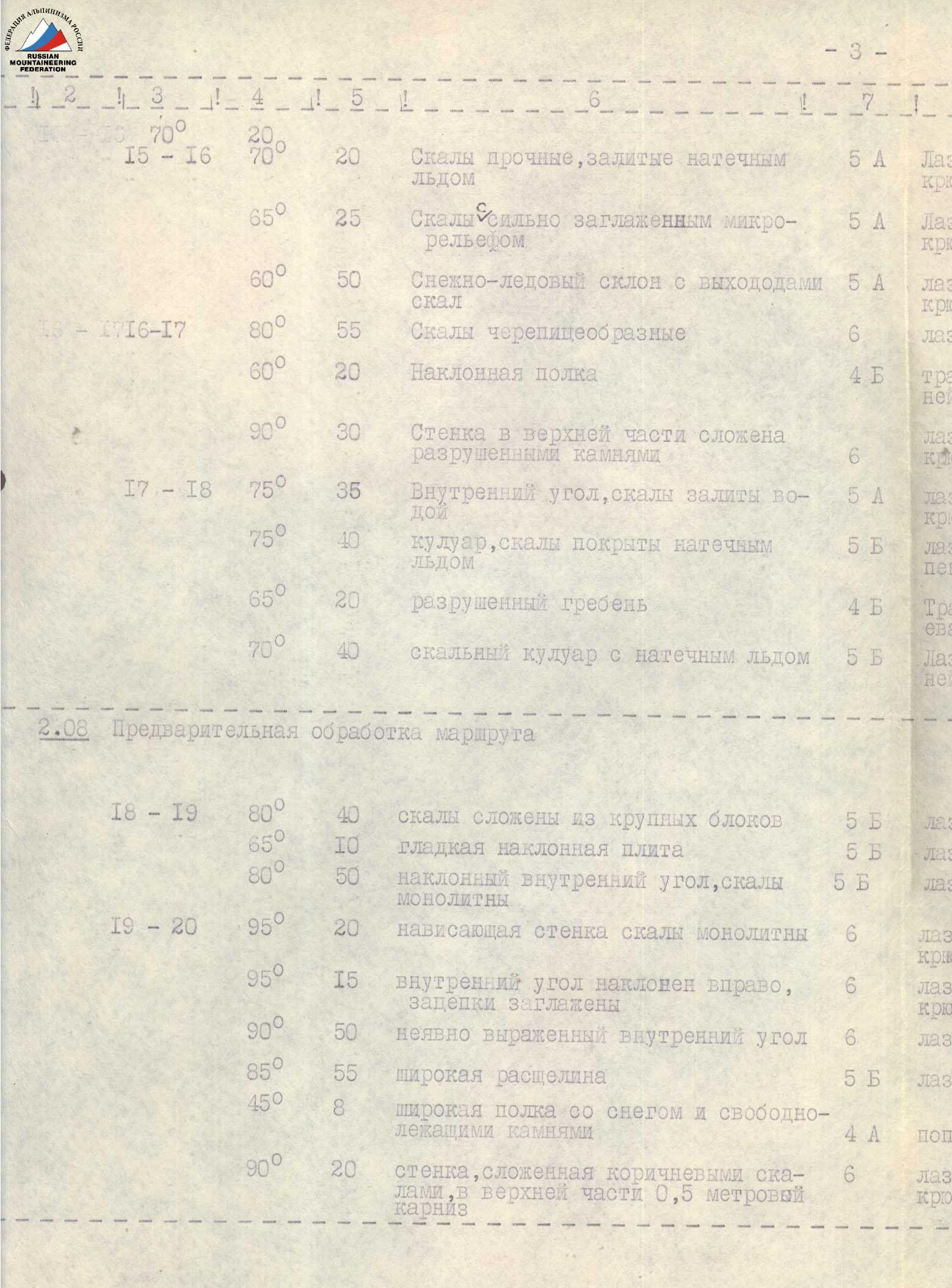
1. Table of main ascent route characteristics
Ascent route — southwest wall of Peak "Ahmad Donish" Route height difference — 2300 m including the most complex sections — 1340 m Route steepness — 75°

| Dates | Passed sections | Average section steepness (by length) | Section length | Section characteristics and passage conditions (by relief) | Section difficulty category | Passage and belay method | Weather conditions | Camping time, departure, climbing hours | Pitons driven: Rock | Pitons driven: Ice | Pitons driven: Bolt | Camping conditions |
|---|---|---|---|---|---|---|---|---|---|---|---|---|
| 29.07 | Preliminary processing of the route | |||||||||||
| R0–R1 | 85° | 60 | "ram's foreheads," rock surface layer heavily destroyed | 5 | difficult climbing, piton belay | cloudless | 11:00 – 18:00 – 7:00 | 8 | – | – | – | |
| R1–R2 | 75° | 40 | slabs, solid rocks, few cracks | 5 | difficult climbing, piton belay | – | – | 5 | – | – | – | |
| R2–R3 | 60° | 35 | rocks made of crumbling carbonaceous shale | 5 | moderately difficult climbing, piton belay | – | – | 4 | – | – | – | |
| R3–R4 | 80° | 10 | internal corner, solid rocks | 5 | difficult climbing, piton belay | – | – | 2 | – | – | – | |
| R3–R4 | 85° | 30 | wall, solid rocks | 6 | difficult climbing, piton belay | – | – | 5 | – | – | – | |
| R4–R5 | 70° | 30 | gully, rocks smoothed | 5 | difficult climbing, piton belay | – | – | 5 | – | – | – | |
| R5–R6 | 80° | 25 | wall made of large blocks | 6 | difficult climbing, piton belay | – | – | 4 | – | – | – | |
| R5–R6 | 50° | 5 | talus shelf with many loose rocks | 4 | alternate, through выступы (rocky outcrops) | – | – | – | – | – | – | |
| R5–R6 | 90° | 25 | internal corner formed by a split | 6 | difficult climbing, piton belay | – | – | 4 | – | – | – | |
| R6–R7 | 50° | 5 | talus shelf | 4 | alternate, through выступы | – | – | – | – | – | – | |
| R6–R7 | 85° | 20 | slab-like rocks, complex, with smoothed handholds | 6 | difficult climbing, piton belay | – | – | 3 | – | – | – | |
| R6–R7 | 45° | 6 | inclined shelf formed by a split | 5 | moderately difficult climbing, piton belay | – | – | 1 | – | – | – | |
| R6–R7 | 70° | 25 | "ram's foreheads" made of marbleized limestone, surface layer heavily destroyed | 5 | difficult climbing, piton belay | – | – | 3 | – | – | camping in the observation camp | |
| 30.07 | Passed processed sections R0–R7 | |||||||||||
| R7–R8 | 75° | 40 | "ram's foreheads" with heavily destroyed surface layer | 5 | difficult climbing, piton belay | cloudless | 19:00 – 11:00 – 8:00 | 5 | – | – | – | |
| R7–R8 | 80° | 10 | internal corner | 5 | difficult climbing, piton belay | – | – | 2 | – | – | – | |
| R7–R8 | 75° | 45 | rocks made of easily flaking shale plates | 5 | difficult climbing, piton belay | – | – | 6 | – | – | – | |
| R8–R9 | 80° | 40 | section of wet rocks | 5 | difficult climbing, piton belay | – | – | 6 | – | – | – | |
| R8–R9 | 90° | 15 | sheer wall, solid rocks, many good handholds | 6 | difficult climbing, piton belay | – | – | 3 | – | – | – | |
| R8–R9 | 70° | 15 | slab-like rocks | 5 | moderately difficult climbing, piton belay | – | – | 2 | – | – | – | |
| R9–R10 | 80° | 20 | internal corner, with a 0.5-meter corniche overhanging in the upper part | 5 | difficult climbing, piton belay | – | – | 4 | – | – | Good, lying down. On a small rocky shelf covered with snow — the site was equipped in 1 hour. | |
| 31.07 | Passed processed section R9–R10 | |||||||||||
| R10–R11 | 65° | 20 | ridge | 5 | moderately difficult climbing, piton belay | cloudless | 18:00 – 9:00 – 9:00 | 1 | – | – | – | |
| R10–R11 | 80° | 15 | steep wall made of solid rocks. Overhung by a snowy cap. Few cracks and handholds | 6 | difficult climbing, piton belay | – | – | 3 | – | – | – | |
| R10–R11 | 65° | 70 | oblique traverse, rocks made of large, unstable blocks | 5 | moderately difficult climbing, piton belay | – | – | 6 | – | – | – | |
| R11–R12 | 60° | 30 | rocks covered with snow | 5 | moderately difficult climbing, piton belay | – | – | 3 | – | – | – | |
| R11–R12 | 45° | 10 | rocky-snowy ridge | 4 | moderately difficult climbing, piton belay | – | – | 1 | – | – | Good, lying down. Organization of the night's stay required minimal physical effort. | |
| R12–R13 | 50° | 160 | stepped snow-ice belt with rock outcrops | 5 | moderately difficult climbing with step cutting, piton belay | – | – | 5 | 3 | – | – | |
| 01.08 | Passed processed section R12–R13 | |||||||||||
| R13–R14 | 50° | 60 | snowy-ice slope, ice gully | 4 | traversing the slope with step cutting, piton belay | morning cloudless, afternoon weather deteriorated | 18:00 – 6:30 – 11:30 | 2 | – | – | – | |
| R14–R15 | 90° | 30 | wall of black rocks, solid rocks | 6 | difficult climbing, piton belay | – | – | 6 | – | – | – |
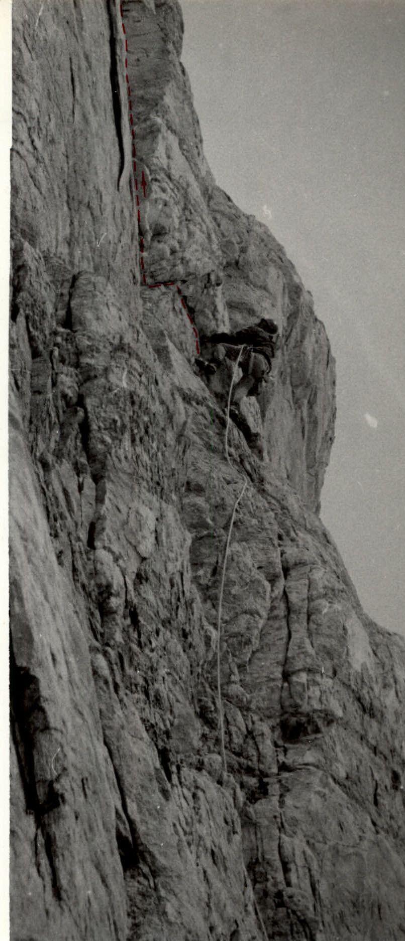
 on section R3–R4.
| Dates | Passed sections | Average section steepness (by length) | Section length | Section characteristics and passage conditions (by relief) | Section difficulty category | Passage and belay method | Weather conditions | Pitons driven: Rock | Pitons driven: Ice | Pitons driven: Bolt | Camping conditions |
|---|---|---|---|---|---|---|---|---|---|---|---|
| R14–R15 | 95° | 6 | нависающий section, rocks covered with ice | 6 | very difficult climbing, piton belay | – | 2 | – | – | – | |
| R14–R15 | 90° | 15 | wall, rocks covered with ice | 6 | very difficult climbing, piton belay | – | 4 | – | – | – |
| Dates | Passed sections | Average section steepness (by length) | Section length | Section characteristics and passage conditions (by relief) | Section difficulty category | Passage and belay method | Weather conditions | Pitons driven: Rock | Pitons driven: Ice | Pitons driven: Bolt | Camping conditions |
|---|---|---|---|---|---|---|---|---|---|---|---|
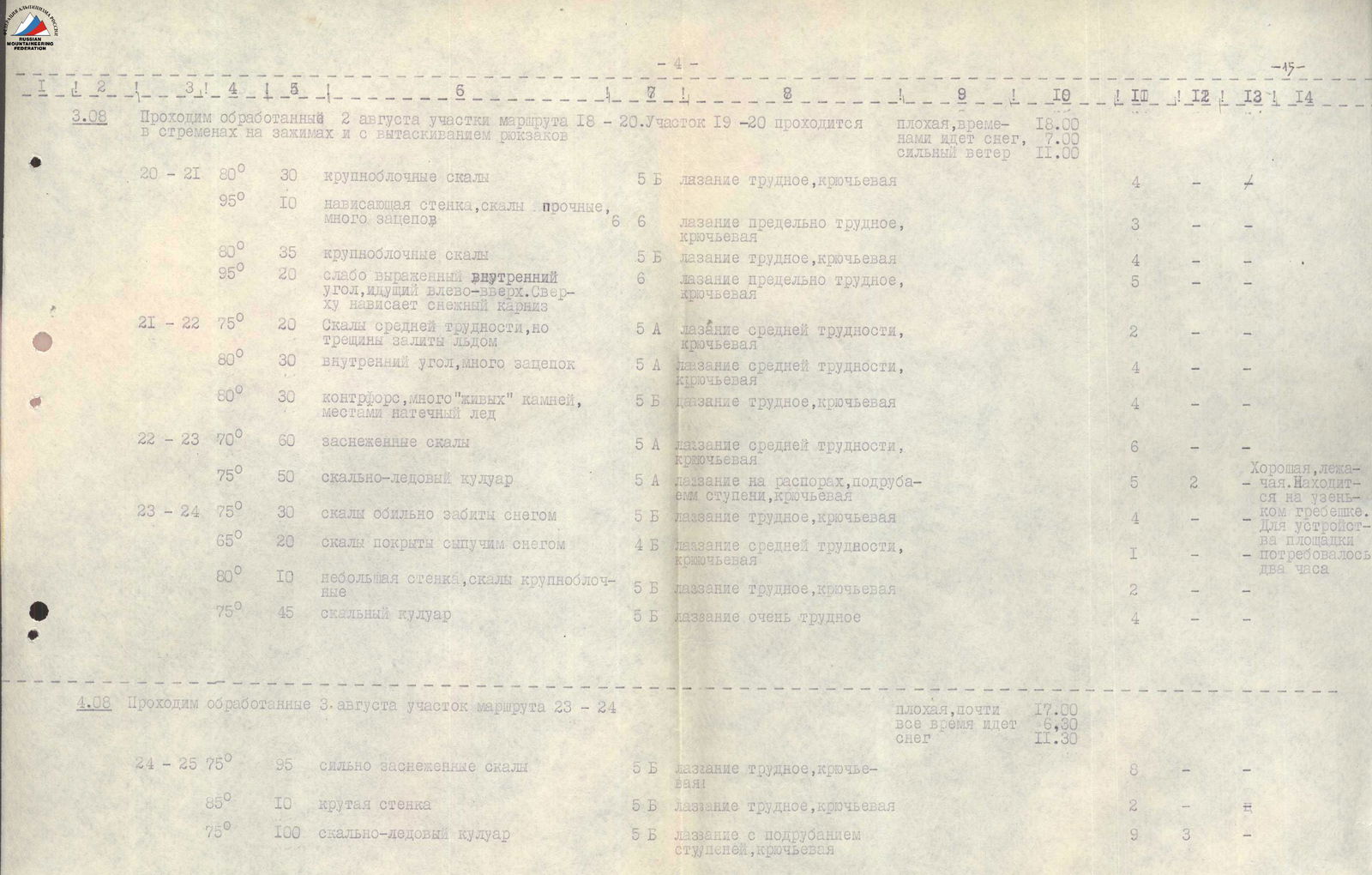
| 03.08 | Passed processed sections R18–R20. Section R19–R20 passed using jammers and pulling up backpacks | ||||||||||
| R20–R21 | 80° | 30 | large-block rocks | 5 | difficult climbing, piton belay | bad, occasional snowfall, strong wind | 4 | – | – | – | |
| R20–R21 | 95° | 10 | нависающая wall, solid rocks, many handholds | 6 | very difficult climbing, piton belay | – | 3 | – | – | – | |
| R20–R21 | 80° | 35 | large-block rocks | 5 | difficult climbing, piton belay | – | 4 | – | – | – | |
| R20–R21 | 95° | 20 | weakly expressed internal corner leading left and upwards. Overhung by a snowy corniche | 6 | very difficult climbing, piton belay | – | 5 | – | – | – | |
| R21–R22 | 75° | 20 | rocks of moderate difficulty, but cracks filled with ice | 5 | moderately difficult climbing, piton belay | – | 2 | – | – | – | |
| R21–R22 | 80° | 30 | internal corner, many handholds | 5 | moderately difficult climbing, piton belay | – | 4 | – | – | – | |
| R21–R22 | 80° | 30 | контрфорс, many "live" rocks, partial ice | 5 | difficult climbing, piton belay | – | 4 | – | – | – | |
| R22–R23 | 70° | 60 | snow-covered rocks | 5 | moderately difficult climbing, piton belay | – | 6 | – | – | – | |
| R22–R23 | 75° | 50 | rocky-ice gully | 5 | climbing on распорах (spreads), step cutting, piton belay | – | 5 | 2 | – | Good, lying down. Located on a snowy pad. Took 2 hours to set up. | |
| R23–R24 | 75° | 30 | rocks heavily covered with snow | 5 | difficult climbing, piton belay | – | 4 | – | – | – | |
| R23–R24 | 65° | 20 | rocks covered with loose snow | 4 | moderately difficult climbing, piton belay | – | 1 | – | – | – | |
| R23–R24 | 80° | 10 | small wall, large-block rocks | 5 | difficult climbing, piton belay | – | 2 | – | – | – | |
| R23–R24 | 75° | 45 | rocky gully |


