Report
On the ascent of Peak Ahmadi Donish via the East Wall
August 3–8, 1966
Team of the Central Council of the Lokomotiv Sports Society
I. Brief geographical description and sporting characteristics of the ascent object
Peak Ahmadi Donish is located in the Academy of Sciences Range in the northwestern part of the Pamir Mountains, between Peak Izvesti (6856 m) and Peak Kalinin (6560 m). The height of Peak Ahmadi Donish is 6667 m. It was discovered in the mid-1930s.
To the southeast of the peak, a lateral ridge extends towards the Bivachny Glacier; to the northwest, another ridge continues, featuring peaks such as:
- Peak Chetyrekh (6380 m)
- Peak Korzhenevskoi (7105 m).
There have been two ascents to Peak Ahmadi Donish. The first ascent was made by a team from the Central Council of Spartak under the leadership of V.M. Abalakov, participating in the competition for the best ascent of the 1959 season.
The second ascent was made by a group from the Central Council of Mekhnat. The route to Ahmadi Donish via the eastern wall is categorized as 5B difficulty. The route is a combination of steep snow and ice ridges, along with snow-covered sheer rock sections. The route features numerous cornices.
2. Climbing conditions in the Bivachny Glacier area
The main challenge for ascents in the Bivachny Glacier area is the remoteness of the climbing objects from alpinist camps and populated areas. The approach to the expedition's base camp, located at the confluence of the Bivachny and Kalinin glaciers on the right orographic moraine of the Bivachny Glacier, from the settlement of Daraut-Kurgan takes 3–4 days, assuming cargo is transported by helicopter. A significant difficulty is the crossing of rivers:
- Sauksay
- Kaindy
- Bilyand-Kiik
- Seldara,
which merge to form the Muksu River.
The base camp is situated at a significant altitude — 3700 m above sea level.
Peaks in the Bivachny Glacier area reach heights of 5000–6000 m or more. The rocks on the peaks are often crumbling, requiring great caution when navigating them. Snow above 6000 m is dry, making travel difficult.
Ridge routes often feature enormous cornices, even on small gendarmes.
Glaciers in the Bivachny area are heavily crevassed. Weather conditions in the Bivachny Glacier area are typical for the Northwestern Pamir. July and August see relatively low precipitation. Precipitation is often accompanied by strong winds. Generally, meteorological conditions are favorable for climbing.
The area around Peak Ahmadi Donish is still largely unexplored for alpinism. Many peaks of significant interest to climbers remain unascended or have been climbed via a single route.
This area allows for climbs of all categories and varying difficulty.
3. Reconnaissance sorties
A. Reconnaissance sortie to the Kalinin Glacier. On July 22, 1953, a group led by Ivanov R. consisting of:
- Khudyakov O.V.
- Kabelsky L.D.
- Bocharov B.A.
embarked on a reconnaissance under Peak Kalinin via the Kalinin Glacier. The task of this group was to determine the feasibility of ascending Peak Kalinin from the Kalinin Glacier. The approach to Peak Kalinin was examined from an unnamed peak at the confluence of the Kalinin and Bivachny glaciers, and then the group assessed the feasibility of approaching Peak Kalinin. The icefall encountered in the lower part of the glacier presented a significant challenge; overcoming it would require a lot of time. On July 25, 1953, the group returned from the reconnaissance.
B. Reconnaissance sortie to the Eleven Glacier.
On July 27, the same group led by Ivanov R. embarked on a reconnaissance to the Eleven Glacier to assess the feasibility of ascending Peak Ahmadi Donish and Peak Kalinin from the Eleven Glacier. The group reached the end of the Eleven Glacier. They made an ascent to a ridge to survey the route to Peak Ahmadi Donish and the route to Peak Kalinin from the saddle between Peak Kalinin and Peak Ahmadi Donish.
After discussing the results of the reconnaissance sorties and considering the complexity and danger of accessing the saddle between Peak Kalinin and Peak Ahmadi Donish, as well as the significant time loss due to the helicopter delay (the group lost two weeks), the coaching council decided:
- to consider Peak Ahmadi Donish as the object of the Lokomotiv Sports Society's expedition;
- to organize a sortie to transport some supplies to the beginning of the ridge of Peak Ahmadi Donish.
On August 2, a group led by Ivanov R., consisting of Kuzmin Yu.P., Starodubtsev V.V., and Khudyakov O.V., made a sortie to the ridge of Peak Ahmadi Donish to transport some equipment and supplies.
They prepared tracks for a rapid ascent up the snow-ice slope during the final group sortie onto the route. A platform for setting up a tent was prepared at the designated location for the first night's bivouac.
5. Planned composition of the assault team and adjustments made before the ascent
Before heading to the mountains, the following composition was planned for the assault team:
Ivanov R.I. — leader Kuzmin Yu.P. — deputy leader Khudyakov O.V. — participant Glybin L.L. — participant Buranbaev B.Zh. — participant Kabelsky L.D. — participant
By a decision of the Presidium of the Lokomotiv Road Council, Kabelsky L.D. was appointed as the leader of the October Railway team participating in the Central Council of the Lokomotiv Sports Society's championship.
This team included:
- Glybin L.L.
- Buranbaev B.Zh.
In their place, Master of Sports Starodubtsev V.V., who served as the head of the rescue team in the expedition, joined the assault team.
The group that ascended Peak Ahmadi Donish consisted of:
Ivanov R.I. — leader Kuzmin Yu.P. — deputy leader Starodubtsev V.V. — participant Khudyakov O.V. — participant
All participants in this group are members of the LIIT sports club and have been participating in joint ascents since 1959.
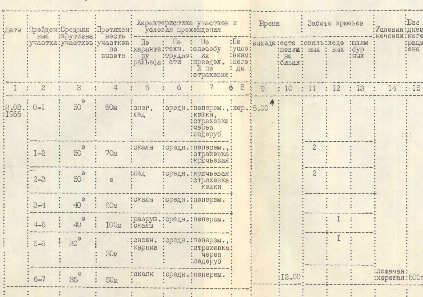
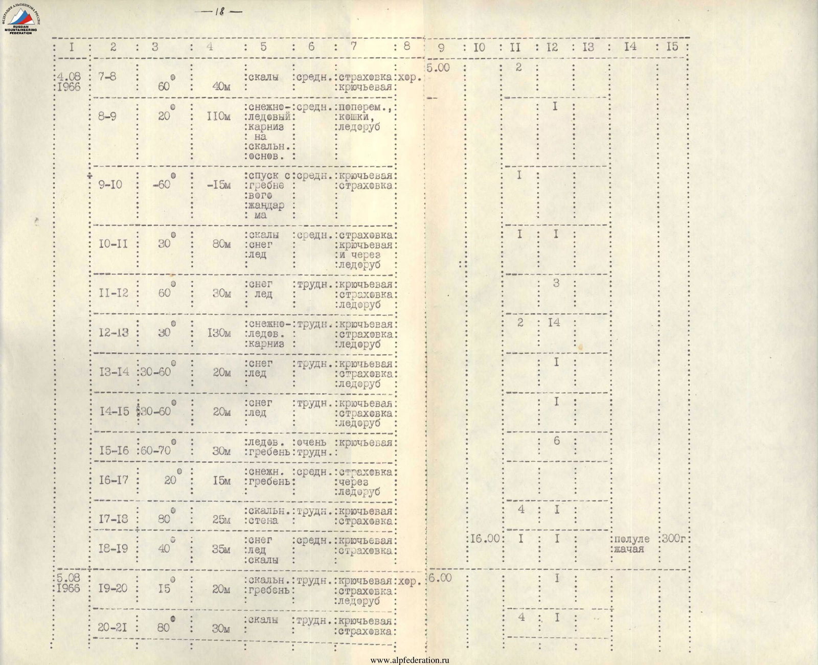
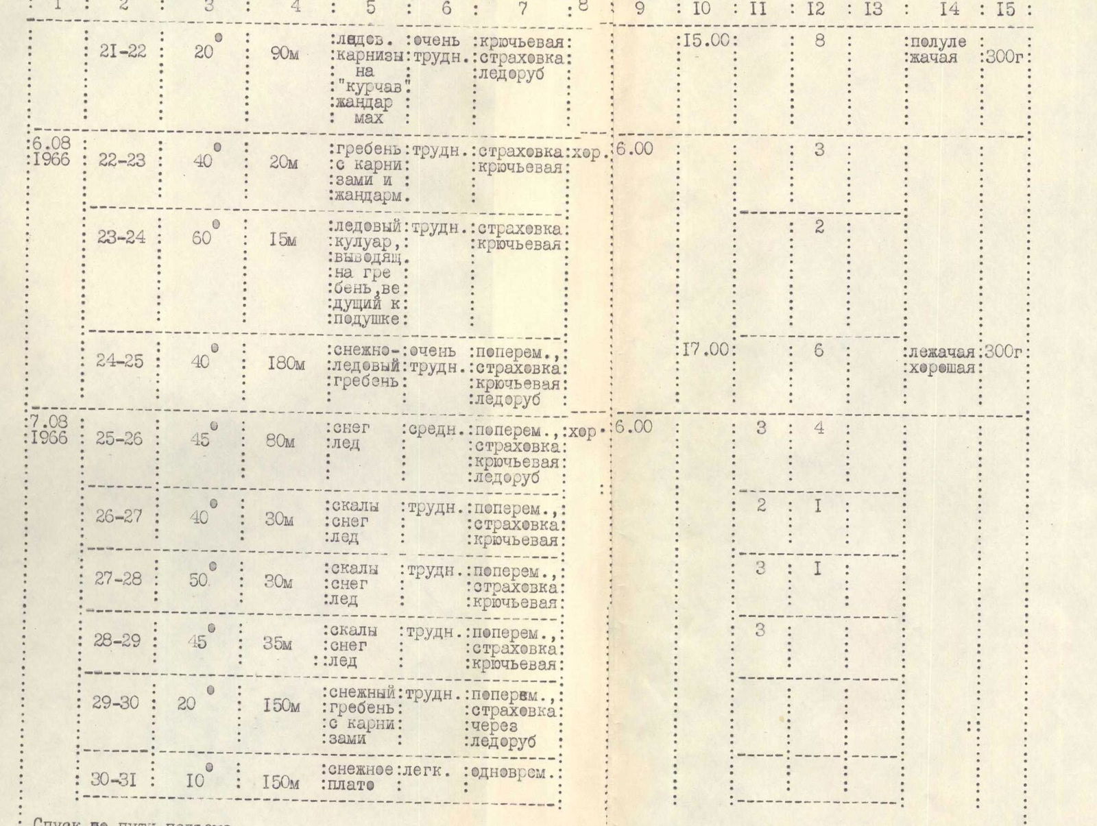
6. Route progression
July 31 — The assault team departed from the base camp, located on the right orographic moraine of the Bivachny Glacier opposite the Kalinin Glacier, to the intermediate camp at 10:00. Following a path, the group approached the confluence of the Bivachny and Eleven glaciers and, after crossing the Bivachny Glacier, stopped for the night near a lake on the left orographic moraine of the Bivachny Glacier, at the mouth of the Eleven Glacier.
August 1 — Departure from the night's bivouac at 9:00. Ascent up the left orographic moraine of the Eleven Glacier to where the glacier levels out. Then, they continued along the glacier to the median moraine of the Eleven Glacier, where the intermediate camp was located. The height of the intermediate camp is approximately 5000 m. The ascent took 4 hours.
August 2 — The assault team departed for the ridge to transport some supplies and equipment under the ridge and to organize a bivouac platform. Departure time was 9:00. They reached under the ridge by 11:30. Descent from the ridge began at 13:00, and they were back at the intermediate camp by 14:00.
August 3 — The team departed for the route at 8:00. Ascent up a steep snow-ice ridge with an average steepness of 45°. The height difference was 390 m. The ascent was made in crampons along the tracks made the previous day. The snow condition was good. In some places, ice was encountered under the snow. The upper part of the ascent went through highly crumbling rocks. Belaying was done using ice and rock pitons, an ice axe, and rock outcrops (section R0–R5).
After reaching the ridge, the group continued moving towards the summit to the previously prepared bivouac site. Movement along the ridge was mostly simultaneous. The rocks were soft and partly crumbling (sections R5–R7). They stopped for a bivouac at 12:00.
August 4 — Departure from the bivouac at 5:00. Ascent up a 40 m rock wall with a steepness of 60° (R7–R8). Belaying was done through pitons. After the wall, there was a 120-meter relatively gentle snow-ice cornice on a rock base (section R8–R9). A short descent (R9–R10) onto a snow-ice ridge led to the base of a 30 m wall, which then led to the ridge (R10–R11). The steepness sharply increased from 30° to 60°. This section was challenging. To progress, they had to dig out and, in some places, cut a trench.
The steep ascent led to a small platform where it was convenient to stop for a bivouac if needed. After the platform, there was a long 150-meter ridge with enormous snow-ice cornices. This section was difficult and was traversed with piton belays (section R15–R16). After this section, there was another ridge with cornices, less complex than the one passed (R16–R17). By cutting a hole in the cornice, they reached a small platform. Here began a section of "curly gendarmes." Between seracs, bypassing a depression in the ridge that steeply dropped on both sides, they approached the base of a steep rock wall, partly covered with ice. Climbing was very difficult (R17–R18). After the wall, along a snow-ice ridge with rock outcrops, they reached a small rock shelf (R18–R19) where they stopped for a bivouac at 16:00. Further progress on the snow became challenging and unsafe due to its softening. The night's bivouac was in a half-reclining position.
August 5 — Departure from the bivouac at 6:00. A small but complex and dangerous ridge with a cornice (R19–R20) led to the base of a steep wall with highly crumbling rocks and, in places, covered with ice. The ascent onto the wall was made by traversing to the right along a steep icy slope descending towards the Eleven Glacier (R20–R21).
After the wall, there was again a ridge with small gendarmes crowned with cornices. In one place, they had to traverse a cornice by cutting a trench in it. Movement was along a very narrow, sharp ridge (R21–R22). From the start of the day, they had to continuously cut a trench. A lot of time was spent on organizing belays. At 15:00, they stopped for a bivouac in a depression of the ridge. Further progress was hampered by the poor condition of the snow. Subsequent sections of the path also lacked a suitable place for a bivouac due to the ridge's steepness and narrowness. While two members prepared the platform, the other pair processed the route.
August 6 — Departure at 6:00. Immediately, they bypassed a huge gendarme on the left along a very steep slope. The slope was icy, with belays through pitons. Further along the slope, cutting a trench, they reached a rock wall leading to the ridge (R22–R23). Again, there was a 500-meter ridge with alternating steep and gentle sections. Large cornices. In places, the ridge turned into steep snow slopes. From the start of the day, they had to cut off the tops of the ridge and make trenches in the snow slopes. The ascent to the "cushion" ended with a very steep snow-ice slope (R23–R25). They stopped for a bivouac on the gentle part of the "cushion" at 17:00.
August 7 — Departure from the bivouac at 6:00. After crossing a wide crevasse, they ascended a steep snow slope towards rocks and then, veering left, bypassed them and reached a rock island. Climbing was of moderate difficulty (R25–R26).
They successively overcame a section where three rock walls were separated by snow saddles. Climbing was difficult. Particularly challenging was the saddle before the third rock wall and the wall itself (R26–R27). The last wall led to a long pre-summit ridge.
The ridge leading to the summit featured large cornices, ascents, and descents. They had to cut numerous trenches (R27–R28). The ridge led to a small snow "cushion," from which, after overcoming numerous ascents and, near the summit, a wide crevasse filled with powdery snow, the group reached the summit at 17:00 (R28–R31).
At 17:20, the group began descending from the summit via the ascent route and was back on the "Cushion" by 20:00, where another bivouac was organized (R31–R25).
August 8 — Departure for descent at 6:00. Thanks to the significant work done the previous day, including cutting trenches and chopping down ridge tops, the descent was sufficiently fast and safe. Only towards the end of the day did the snow soften again, slowing the group's movement. Still, on the same day, by 19:30, the group was down on the Eleven Glacier (R25–R0). The group's descent was also facilitated by the overcast and cold weather, which significantly delayed the snow's softening.
7. Overall assessment of the actions of the assault participants
Group participants Kuzmin Yu.P., Khudyakov O.V., and Starodubtsev V.V. were well-prepared for high-altitude ascents. Everyone felt good and managed to ascend from the "cushion" of the hanging glacier to the summit and descend in one day. All participants took turns leading, processing the route for the others. The participants are proficient in alpinism techniques and maintain safety.
8. Data on the auxiliary group
The auxiliary group consisted of:
- Varentsov V.M. — 1st sports category — leader
- Volovets L.D. — 2nd sports category — participant
- Erofeeva G.F. — 2nd sports category — participant
- Zysin S.L. — 3rd sports category — expedition doctor.
The auxiliary group assisted in organizing the expedition and served as a link between the assault team and the base camp. Communication between the assault team and the auxiliary group during the ascent was maintained using the "Nedra 2P" radio station. The communication was stable.
Signatures of the ascent participants
Ivanov R.I. Starodubtsev V.V. Kuzmin Yu.P. Khudyakov O.V.
Table of the main route characteristics
Route of ascent: Peak Ahmadi Donish via the eastern wall, category 5B difficulty. Height difference of the route: 1670 m. Including the most complex sections: 300 m. Steepness of the route: 35–40°. Including the most complex sections: 30–70°.