
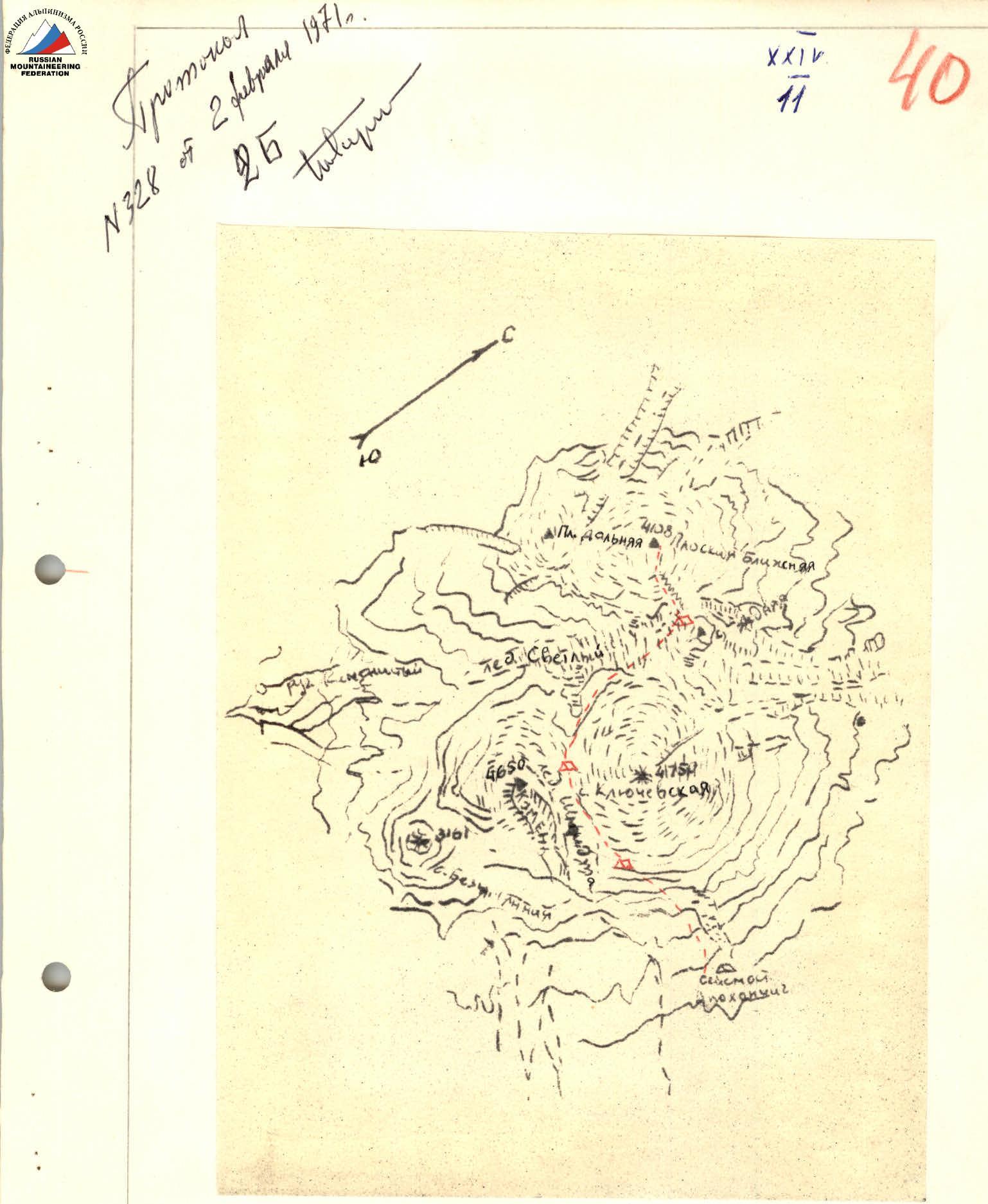
 Cartographic scheme of the area
Description of the ascent to Ploskaya Blizhnyaya peak via the eastern ridge, category 2B difficulty
Ploskaya Blizhnyaya sopka is part of the Klyuchevskaya group of volcanoes. This peak in Kamchatka is the third highest. Its absolute height above sea level is 4108 m.
Ploskaya Blizhnyaya sopka is of volcanic origin. It is an old extinct volcano. Its slopes are composed of volcanic rocks:
- basalt,
- tuff,
- diabase.
The peak rises above the largest glacier in Kamchatka - the Svetly glacier. The height above sea level in this area is 2700 m.
The sopka has a very large glaciation from the foot to the summit. The glaciers flowing down to the northeast and east flow into the Svetly glacier. On the eastern side, in the areas of sheer walls, there are quite extensive rocky ridges composed of strong and loose volcanic rocks. To the northeast - sheer rocky and icy walls from the summit to the Svetly glacier (ancient volcanic crater). The northern slopes of the sopka are gentle and are of no particular interest from an alpinism point of view. To the west, the sopka is connected by a vast glaciated isthmus with Ploskaya Dalnyaya sopka. The summit of the sopka is a powerful dome-shaped glacier with a slight slope in all directions except the northeast, where it is bounded by the walls of the ancient crater.
In the area under consideration, snow lies at the foot even in very warm times of the year.
The weather in this area is unstable. From the second half of the day, it often snows.
The most favorable time for the ascent is considered to be the period from July 20 to September 1.
2. Approach to the starting point of the ascent
a) Traveling by vehicle.
By car, drive on a dirt road from the village of Klyuchi to the Apokhonchich seismic station. The distance is 80–90 km.
The dirt road goes around the foot of Klyuchevskoy volcano in a large arc from west to south. Most of the road passes through:
- alder forest,
- birch forest.
Traveling by car is possible from July 1 to October 10. In winter, communication is carried out by dog sleds.
Cars regularly travel to the seismic station from the branch of the Kamchatka Institute of Volcanology in Klyuchi 3–4 times a month.
The seismic station is located at an altitude of about 700 m above sea level at the end of the frozen lava river Apokhonchich, which flowed out during the eruption of Klyuchevskoy volcano in 1948. Around the station is a vast slag plateau, cut by dry rivers and rare islands of alder shrubs.
The station has been operating year-round since 1957. There is a radio station, with regular communication with Klyuchi - 2 times a day.
There is no water, firewood, or gasoline at the seismic station. All this is delivered from Klyuchi by car and helicopter.
The car ride takes 5–6 hours.
b) Hiking to the starting point of the ascent.
Day 1.
Move up the right bank of the dry river (filled with dirty water from the second half of the day). Direction - to the upper reaches of the Schmidt glacier.
It is possible to travel on horseback.
The camp should be set up at the left-bank moraine of the Schmidt glacier.
Height 2100 m.
Time spent on the transition - 5–6 hours.
Day 2.
Direction of movement - to the upper reaches of the Schmidt glacier. Klyuchevskoy volcano is bypassed with a gradual gain in height. When moving, several gentle couloirs are crossed, filled with snow and ice, sprinkled with slag. In the second half of the day, stones "move" along the couloirs, low clouds cover the entire path. Therefore, a very early exit from the overnight stay is recommended.
When moving:
- It is not recommended to go out onto the Schmidt glacier.
- The glacier can only serve as a good landmark, limiting the route on the left when moving in the fog.
Exit to the isthmus between Klyuchevskaya and Kamen volcanoes. Here, to the east, are the sources of the Schmidt glacier, to the west - the Svetly glacier.
Here, on the glacier, there are many convenient areas covered with slag. There is water. From this camp, it is convenient to ascend:
- Klyuchevskoy volcano, category 2A difficulty
- Kamen volcano, category 4A difficulty
Traveling on horseback to this camp is not possible. There are areas for receiving helicopters and cargo dropped from planes and helicopters.
Height 3300 m. Time spent on the transition 7–8 hours.
Day 3.
From the isthmus, down to the Svetly glacier. Direction of movement - to the northwest along the closed glacier. Further through the Svetly glacier under the route itself. In these places, the Svetly glacier is a slightly hilly terrain with a slope to the southwest.
Features of the Svetly glacier:
- In the absence of prolonged precipitation in August, the glacier looks like a black plateau (completely covered with slag), densely dotted with white veins of crevasses.
- If the glacier is covered with snow, it is recommended to move in teams.
Direction of movement along the Svetly glacier - under the route (see photo 1). Set up camp under the route. Many convenient dry areas. There is water.
Height above sea level 2670 m. Time spent on the transition 7–8 hours.
3. Description of the route by sections
The relative height of the ascent from the start of the climb to the summit is 1440 m.
Section 1
Height difference 250 m. Steepness 25–30°, on rocky areas up to 43°. Along the slag talus and a small snowfield to the left in the direction of the upper part of the glacier between Ploskaya Dalnyaya and Ploskaya Blizhnyaya volcanoes. Further exit along the rocky ridge to the icefall. Rocks are simple.
The rocky ridge is densely settled small and medium talus of volcanic rocks.
Duration of movement 1 hour 20 minutes.
Section 2
Height difference 400 m. Steepness at the beginning of the movement 30°, on most of the section 20°. Crossing the icefall, 120 m, and exit to the closed glacier (photo 2). Along the glacier, 250 m, under the bergschrund. Through the snow-ice bridge to the open glacier with a traverse to the right to the rocks, 3 ropes, piton belay.
Duration of movement 2 hours 30 minutes.
Section 3
Height difference 600 m. Steepness 30–40°. Rocky ridge, representing frozen lava in the form of kekur. Rocks are strong, simple to pass.
Move straight up the rocky ridge with an exit to the firn steep slope. Along the firn slope, 2 ropes, exit to a long narrow snow ridge with powerful cornices on the right.
Duration of movement 3 hours 00 minutes.
Section 4
Height difference is insignificant. Steepness 10°. Dome-shaped closed glacier. On the left - a very steep snow-ice slope towards the isthmus. On the right - powerful snow cornices above the rocky and icy walls (photo 3).
Movement along the glacier. Direction - to the rocks. Duration of movement 2 hours 30 minutes.
Section 5
Height difference 190 m. Steepness 45–50°. Talus, heavily snow-covered and icy rocks of medium difficulty.
Along the rocks, exit to the left under the gendarme. Bypass the gendarme - on the left.
Further along the closed glacier along the snow cornices hanging over the ancient crater.
The summit is a small rise and broadening above the icy ridge, in the form of a snow dome.
Exit to the summit - snow-ice slope, 3 ropes.
Since the summit is heavily snow-covered, the note is left on the most noticeable, closest to the summit gendarme, 7 m high (photo 4). The note is attached to a rock piton driven into the upper part of the gendarme.
Duration of movement 2 hours 00 minutes.
4. Descent from the summit
On sections R5, R4, and R3, descend along the ascent route. When approaching the second section:
- descend straight down the steep icy rocky ridge, 2 ropes;
- further descent through the bergschrund in a sportsmanlike manner, 15 m, to the closed glacier.
Further descent coincides with the ascent route. Duration of descent 3 hours.
5. Calculation of the time taken to complete the route by days and hours
Days 1–3 - approach from the seismic station under the route. Day 4: Section 1 - 1 hour 20 minutes Section 2 - 2 hours 30 minutes Section 3 - 3 hours 00 minutes Section 4 - 2 hours 00 minutes Section 5 - 2 hours 00 minutes Descent to camp - 3 hours 00 minutes Total: 13 hours 50 minutes
6. Recommendations to climbers
When approaching from the Apokhonchich seismic station to the isthmus at 3300 m, carefully mark the entire route.
Start the ascent no later than 3:00.
Special equipment for a group of 4 people: a) main rope: 2 × 40 m b) rock pitons: 3 pcs. c) ice screws: 4 pcs. d) carabiners: 3 pcs. e) auxiliary cord: 2 m f) crampons: 4 pairs
Description compiled by © S. Grinkevich, December 3, 1970
Comments
Sign in to leave a comment