The Ganal'skiye Ostryaki ridge is located in the center of the Kamchatka Peninsula, within the overall system of the large Eastern ridge (see area diagram).
It is convenient to approach the object of ascent from the city of Petropavlovsk-Kamchatsky by car with high проходимости (cross-country capability). From the city, take the Milkovskaya highway to the bridge over the Vakhtang Malkinsky river between 145 and 146 km (see map-diagram №2). Turn onto the forest road after the bridge. Along it, 8–9 km along the river in the valley to a large clearing, where the forest road ends.
To the left of the road is a passage in the alder bushes - the beginning of the hiking part of the route. Further:
- Follow the trail along the left bank of the valley. Do not turn up to the left.
- The trail leads to a terrace. Along it - to a dry riverbed crossing the trail, to dry forest and bushes.
- Cross to the other bank of the riverbed and ascend along it for 50–70 m.
- Then the trail turns right - follow it to a stream flowing from Yurчик mountain.
- Cross the stream, go along it down for 100–150 m to a terrace above the stream flowing from the Ostряки cirque.
- Follow the trail on the terrace for 800 m to cedars on moraine cushions.
That's a good spot for a base camp.
The hiking part of the route is 4 km, 1.5–2 hours with a load. Time from the city - 4–5 hours.
In the Ganal'skiye Ostryaki cirque, a helicopter landing is possible. Flight time - 20–25 minutes.
Approach from the base camp to the route (see photo):
- Up along the stream
- Further along the stone moraine for 1 km to a snowfield lying in the cirque between Yurчик mountain and Ostryaki
- Cross the stream and exit onto the glacier
- Cross the glacier straight up to the base of a narrow snow-ice couloir descending from under the wall of Ganal'skiy Palets
The beginning of the route.
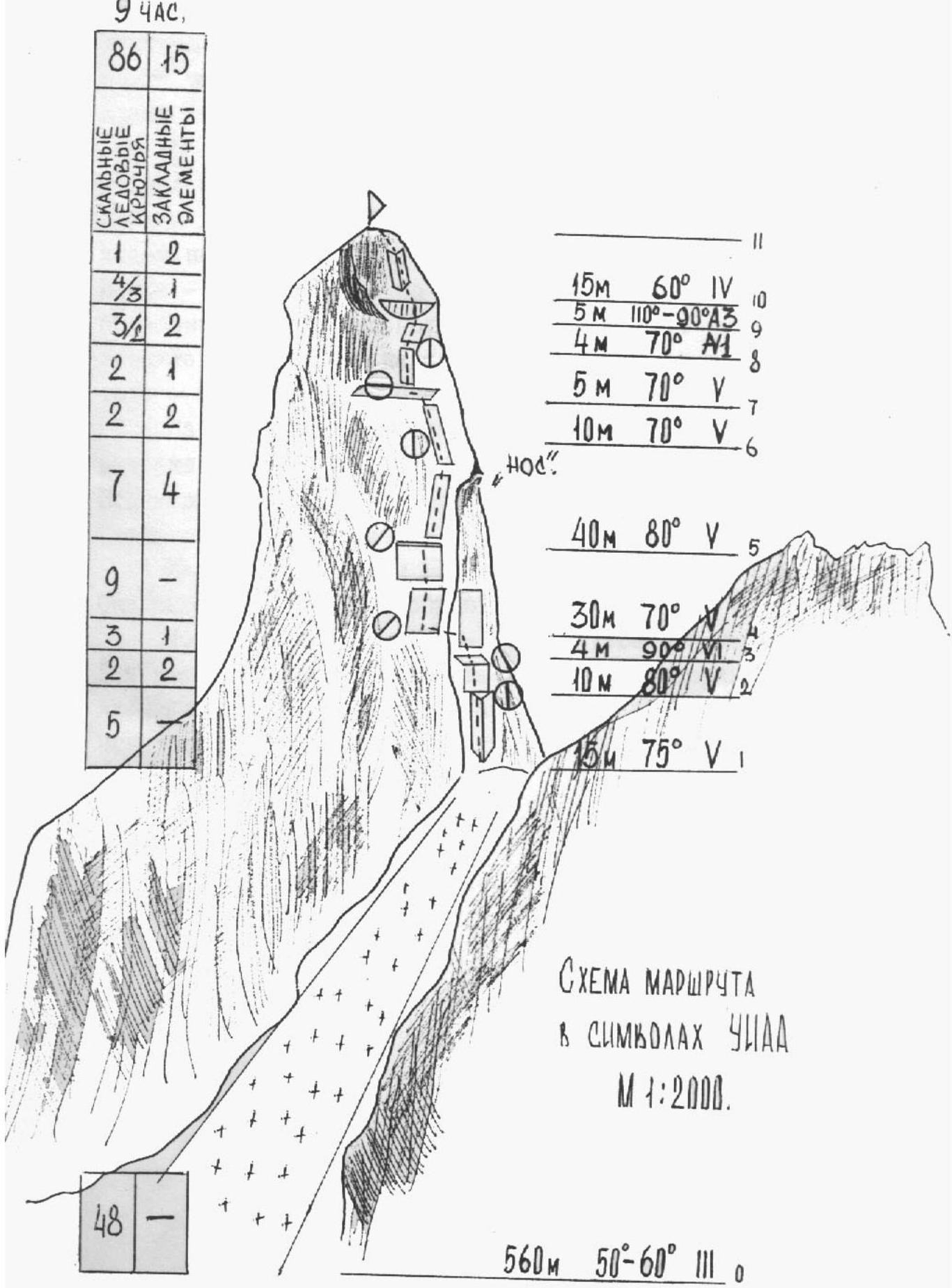
Description of the route by sections
The beginning of the route is through a narrow snow-ice couloir with a steepness of 50–60° (see photo).
When ascending, move along the right part of the couloir. Key insurance on rocks is possible. The couloir leads to a snow saddle under the rocky part of the route. Time from the start of the route - 3 hours.
From the saddle, 15 m along the inner corner (small holds, galoshes on friction), difficult climbing (see UIAA diagram, route profile). Then 10 m along smooth slabs to a ledge. From the ledge, 4 m up and to the left along a slab, exiting to the left side of the Southwest edge. Further movement is up and to the right along rocks of 5th category difficulty to a site located above a rocky outcrop ("Nos").
For sections 4–7, reverse layering of rock layers is characteristic. As a result, overcoming numerous small overhangs.
On section 7 - the only shelf where a sitting bivouac is possible.
From the shelf, movement is:
- straight up along a slab for 5 m under an overhang;
- under the overhang: up and to the right for 4 m along a slab to a crack in the overhang.
Very difficult climbing. IT.
The overhang (with a 1.5 m outreach) is passed head-on through the crack. It leads to a 4-meter wall (90° IT).
The last section, 10–11, is an inner corner of 4th category difficulty. For the last 30 m of the route, a dense layer of lichen on the rocks is characteristic, which significantly hinders climbing and finding cracks for insurance organization. Otherwise, the route is safe, not prone to rockfall.
Descent from the summit: the safest and most logical descent is via the ascent route.
Tactical actions of the team
During the ascent to the summit of Ganal'skiy Palets, the Farbеrov - Panyukhin group fully adhered to the tactical plan of ascent. At 10:00, the group reached the saddle, where bivouac equipment and equipment necessary for passing the snow-ice part of the route were left. As a result, for further passage of the route, all the group's equipment weighed no more than 7 kg. The first on the route passed rocky sections of 5th and 6th category difficulty without a backpack. In the Farbеrov - Panyukhin group:
- each participant works equally on the route of increased complexity.
For passing complex sections where IT was required, hook ladders with tape rungs were used.
The diverse relief of Ganal'skiy Palets allowed for quick and reliable organization of:
- intermediate points;
- main insurance stations.
This allowed for acceleration of the passage of the rocky part of the route. The group reached the summit at 15:00, which was 30 minutes earlier than planned.
The rescue team was located in the base camp, observation of the ascending group was carried out with the help of binoculars. For communication, signal flares were agreed upon in extreme cases.
 Pau-da-obi-ki-ni П-aa-ri (PIII7m) 94AC.
Pro-fi-ad Ma-du-py-ta
M 1:1000
