314 294
DESCRIPTION OF THE ASCENT TO KORYAKSKY VOLCANO VIA THE NORTHEAST RIDGE, CATEGORY 3B
Category 3A (voice)
- GENERAL DESCRIPTION OF THE PEAK AND ITS LOCATION
See the description of the ascent to Koryaksky volcano via the South Ridge, category 3B.
- TRANSITION TO THE STARTING POINT OF THE ASCENT
See the description of the ascent to Koryaksky volcano via the South Ridge.
The dry riverbed is blocked in its upper reaches by an elevation overgrown with dense alder bushes. Only near the left bank, the river flowing from the Avachinsky glacier has carved a deep, narrow, solid bed. The river is turbulent and very muddy.
The road continues along the right bank of the dry riverbed through thickets of alder bushes to the volcanological station. Practically, this road can be traversed at the end of July to October. The gullies filled with snow pose a serious obstacle for ordinary vehicles during May-July. If the vehicle cannot pass, further movement is on foot.
The best passage is closer to the left bank of the dry riverbed through sparse alder bushes. The walking time to the volcanological station is 1 hour 15 minutes to 1 hour 30 minutes.
The volcanological station of the Kamchatka Institute of Volcanology, Siberian Branch of the USSR Academy of Sciences, is located at the foot of Avachinsky and Koryaksky volcanoes in an open area.
Surrounding vegetation:
- mountain tundra
- sparse clusters of low-growing alder and cedar bushes
At the volcanological station:
- round-the-clock observations of active volcanoes are conducted throughout the year
- staff consists of 2-3 people
- students on internship are present in the summer
- there is regular, stable radio communication with Petropavlovsk-Kamchatsky
- there is no regular communication between the station and the Institute of Volcanology
- in winter, such communication is very rare
If the group of climbers is small (4-6 people), they can count on overnight stay at the volcanological station. There are many good campsites around the station, but there is no firewood. It is necessary to bring firewood when crossing the dry riverbed by car.
It is recommended to establish a base camp near the volcanological station. The absolute height at this location is 900 m. The relative height gain to the summit is 2456 m.
- DESCRIPTION OF THE ROUTE BY SECTIONS
Section 1. Height difference 300 m. Slope 10° at the beginning, increasing to 20-30°. Small and medium rock debris, firn. Duration 1 hour 30 minutes. From the volcanological station, the direction is towards the Avachinsky pass. The pass is blocked by a hill resembling a double-humped camel, known as "Verblud" (Camel). The passage is through a couloir between the Southeast ridge of Koryaksky volcano (route 2A) and the left "hump" of Verblud hill. The gully leads to an extensive firn field with small slag islands.
Section 2. Height difference 300 m. Slope 20-30°. Medium diabase debris, snow-firn slopes of small extent. Duration 2 hours. The direction is generally northward with a gradual gain in height.
Movement should be guided by visual assessment of the feasibility of passing through snow-firn and debris slopes. It is not advisable to ascend steeply, as crossing ridges will result in significant height loss.
The section ends at the intersection with the 1st ridge (see photo 1).
Section 3. Height difference 400 m. Slope 20-30°. Snow-firn couloir, traversing with height gain. Movement in rope teams. Simultaneous belay. Duration 3 hours. After crossing the extensive couloir, the section ends at the 2nd ridge (see photo 1). When approaching the 2nd ridge, be cautious: rocks may fall from the slopes.
Section 4. Height difference -50 m. Slope 25-30°. Ice slope with small rock inclusions. Movement in rope teams. Alternate belay through rock outcrops. Duration 1 hour.
Section 5. Height difference 250 m. Slope 25°, increasing to 40° near the ridge. Ice couloir with small firn fields. Movement in rope teams. Simultaneous and alternate belay. Duration 1 hour 30 minutes. Four gendarmes are also passed directly with piton belay (height of gendarmes 5-8 m).
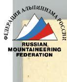
Section 6. Height difference 550 m. Slope 20-25°. The ridge is composed of heavily destroyed basalt rocks. Several small gendarmes. One long gendarme, 6-8 m high (bypassed on the right). Movement in rope teams. Simultaneous belay. Duration 2 hours 30 minutes. The section ends before a rock wall about 20 m high. Before the wall, there is a horizontal area of medium rock debris, 4×10 m in size. It is recommended to set up an overnight camp here. There is no water; snow is available. This is a control cairn.
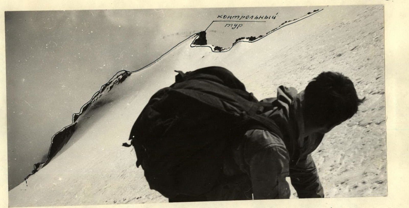
Section 7. Height difference 450 m. Overall slope 35°; rock walls 60-80°. An array of rocks of medium difficulty, considerable extent (see photo 2). To the left, the rocks drop off with a sheer wall of 150-200 m; to the right, they converge with an ice couloir - a rock-ice slope with a slope of 45-50°. Movement in rope teams. Alternate belay through rock outcrops and pitons (rock and ice). The rock wall (1 rope, piton belay) is passed; a snowy, gently sloping ridge running from north to south leads to the summit cairn. The cairn is on rocks. The section ends at the upper part of the ridge, where it dips under the ice slope. Control cairn. Duration 4 hours 30 minutes.
Section 8. Height difference 240 m. Slope 40°. Ice slope covered with a thin layer of snow. Movement in rope teams. Alternate belay through ice screws. Duration 4 hours.
Section 9. Height difference 80 m. Slope 50°. Ice slope covered with a thin layer of snow. Movement in rope teams. Alternate belay through ice screws. Duration 40 minutes. The direction is towards a rock "tooth" 60 m high. The "tooth" is bypassed on the right (see photo 3).
Section 10. Height difference 36 m. Slope 25°, decreasing to 10° near the summit. Ice slope covered with deep snow. Movement in rope teams. Alternate belay through ice axe. Upon reaching the summit ridge, simultaneous belay is used. Duration 20 minutes. The slope leads to a flat summit area.
When traversing the couloir, simultaneous belay is used. When reaching the 3rd ridge, alternate belay (3 ropes) through ice axe is used. At the beginning of the traverse, proceed with caution. Near the 2nd ridge, there is a path of rockfall. Rocks fall infrequently.
- DESCENT FROM THE SUMMIT
Descent via the Southeast ridge, route 2A. Duration 6 hours.
- TIME CALCULATION FOR THE ROUTE BY DAYS AND HOURS
Day one. Arrival at the volcanological station.
Day two.
- Sections R1-R4
- Section 5 - 1 hour 30 minutes
- Section 6 - 2 hours 30 minutes
Total: 11 hours 30 minutes.
Day three.
- Section 7 - 4 hours 30 minutes
- Section 8 - 4 hours
- Section 9 - 40 minutes
- Section 10 - 20 minutes
- Descent from the summit - 6 hours
Total: 15 hours 30 minutes.
Note: The time breakdown is given for local climbers making the ascent on weekends.
-
RECOMMENDATIONS FOR CLIMBERS
-
Due to rockfall hazard, Sections 3 and 5 should be traversed with visibility of at least 300-400 m.
-
After snowfalls, due to avalanche hazard on Sections 3 and 5, the route is not recommended.
-
In case of poor visibility or the situation described in point 2, it is recommended to ascend from the beginning of the 3rd ridge. The transition to the ascent ridge from the pass involves descending northeast with a height loss of up to 800 m above sea level. In this variant, the ascent time increases by 5-6 hours.
-
Section 7 can be traversed by bypassing the rock massif on the right via an ice slope with a slope of 40-50°. In one place, there is a section 20-25 m high with a slope of 60°. In this variant, there will be alternate belay throughout the section using ice screws, with step cutting. Given that, in case of a fall, the body will slide down the ice couloir for 700-900 m, this movement variant is less preferable than the one described.
-
On Sections 8 and 9, there may be crevasses covered with snow, running across the slope.
-
Number of participants: 4-6 people.
-
Special equipment for a group of 4 people: a) main rope - 2×40 m; b) rock pitons - 8 pieces; c) ice screws - 6 pieces; d) carabiners - 8 pieces; e) rock hammer - 2 pieces; f) auxiliary rope - 8 m; g) crampons - 4 pairs.
Description compiled on October 29, 1969 (S. Grinkevich)

Map Diagram
Avachinskaya group of volcanoes
- approach route
- ascent route
 www.alpfederation.ru↗