Report
On the First Ascent to the Summit
VULCAN VILUCHINSKAYA SOPKA, 2173 m above sea level (Kamchatka Krai, Yelizovsky District, Eastern Ridge) — THROUGH THE WESTERN SLOPE 2B category of difficulty (combined); climbed on May 22, 2021, by the team of KhRRO "Khabarovsk Regional Alpine Federation"

I. Climbing Report
| № | 1. General Information | |
|---|---|---|
| 1.1 | Full name, sports rank of the leader | Krasnolutsky Alexander Vyacheslavovich, Candidate Master of Sports |
| 1.2 | Full name, sports rank of the participants | Gorokhov Kirill Gennadyevich, 3rd sports rank; Kovaleva Svetlana Borisovna, 3rd sports rank; Sitnikov Denis Yuryevich, 3rd sports rank; Antonov Anton Igorevich, Alpine Climbing Instructor; Mironov Anton Anatolyevich, Alpine Climbing Instructor |
| 1.3 | Full name of the coach | Krasnolutsky Alexander Vyacheslavovich |
| 1.4 | Organization | KhRRO "Khabarovsk Regional Alpine Federation" |
| 2. Characteristics of the Climbing Object | ||
| 2.1 | Region | Kamchatka Krai, Yelizovsky District |
| 2.2 | Valley | - |
| 2.3 | Section number according to the classification table | 3. Kamchatka |
| 2.4 | Name and height of the summit | Vulcan Viluchinskaya Sopka, 2173 m above sea level |
| 2.5 | Geographical coordinates of the summit | 52°42′18.0″ N, 158°16′52.4″ E |
| 3. Characteristics of the Route | ||
| 3.1 | Name of the route | Through the western slope |
| 3.2 | Proposed category of difficulty | 2B (combined) |
| 3.3 | Degree of route development | First ascent; date of first ascent unknown |
| 3.4 | Character of the route terrain | Combined. Snow-ice couloirs intersected by rocky ridges, leading to the summit rocky bastion. |
| 3.5 | Height difference of the route | 1720 m |
| 3.6 | Route length | 5100 m |
| 3.7 | Length of sections of various categories of difficulty indicating the terrain character | 0–1, 1st category of difficulty — 550 m, 3rd category of difficulty — 350 m, 2nd category of difficulty — 1650 m, 4th category of difficulty — 250 m. Snow-firn slopes and couloirs separated by rocky ridges. |
| 3.8 | Descent from the summit | Via route 2A on the NW slope (Panchenko V.) |
| 3.9 | Additional characteristics of the route | Approach to the start of the route is about 1 km from the car. Average slope 30.0°, maximum about 60.0°. In winter, the route may be completely covered with snow. In August, in warm years, snow may be preserved only in the upper part of the route, above 1700 m above sea level; in summer, there is a high risk of rockfall on some sections of the route with a slope of 50° or more. |
| 3.10 | Equipment used | Ropes 50 m — 2 pcs. Ice screws 220 mm with quickdraws — 10 pcs. |
| Anchor pitons — 2 pcs. Local loops — 4 pcs. |
4. Characteristics of the Team's Actions
| № | 4. Characteristics of the Team's Actions | |
|---|---|---|
| 4.1 | Time of movement (team's walking hours) | 10.5 hours, including approach to the route 0.5 hours, ascent 6 hours, descent and return 3.5 hours |
| 4.2 | Overnight stays | - |
| 4.3 | Start of the route | 6:10 on May 22, 2021, start, 6:45 beginning of work on the route |
| 4.4 | Reaching the summit | 12:50, 13:20 start of descent |
| 4.5 | Return to the base camp | 16:45 |
| 5. Responsible for the report | ||
| 5.1 | Full name, e-mail | Gorokhov Kirill Gennadyevich gokigenn@mail.ru +7(909)856-6232 |
II. Climbing Description
1. Characteristics of the Climbing Object
1.1. General Photo of the Summit
Photo 1. View of the summit of Vulcan Viluchinskaya Sopka from the west from the Paratunka River valley.
Photo 2. Same, with route lines.
Photo 3. View of the summit from the north (from the start of the routes).
Photo 4. View of the summit from the southwest (August 2021).

Photo 1. General photo of the summit from the west

Photo 2. General photo of the summit from the west with route lines
- Red line — described route (part of the route behind the ridge)
- Yellow line — route 2A on the NW slope, V. Panchenko (descent line)

Photo 3. Photo of the summit from the north (from the start of the routes)
- Red line — described route (part of the route behind the ridge)
- Yellow line — route 2A on the NW slope, V. Panchenko (descent line)
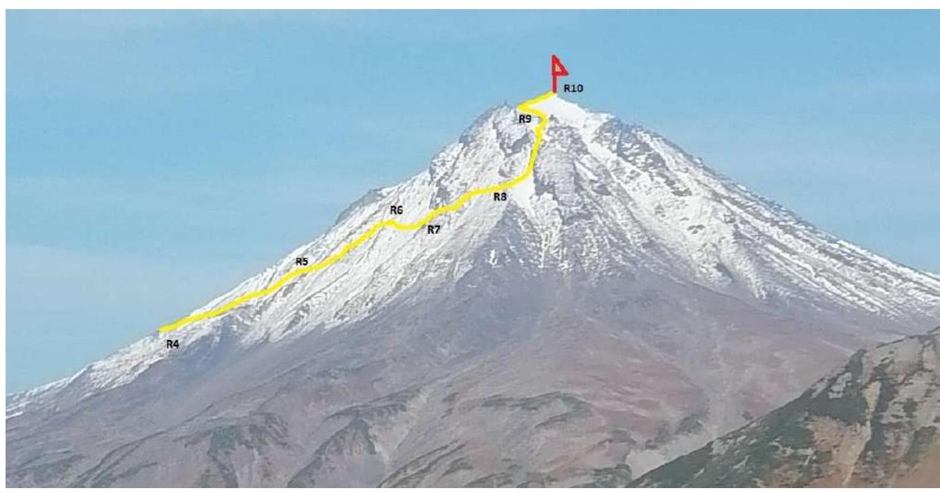
Photo 4. View of the summit from the southwest (descent from Viluchinsky Pass, August 2021)
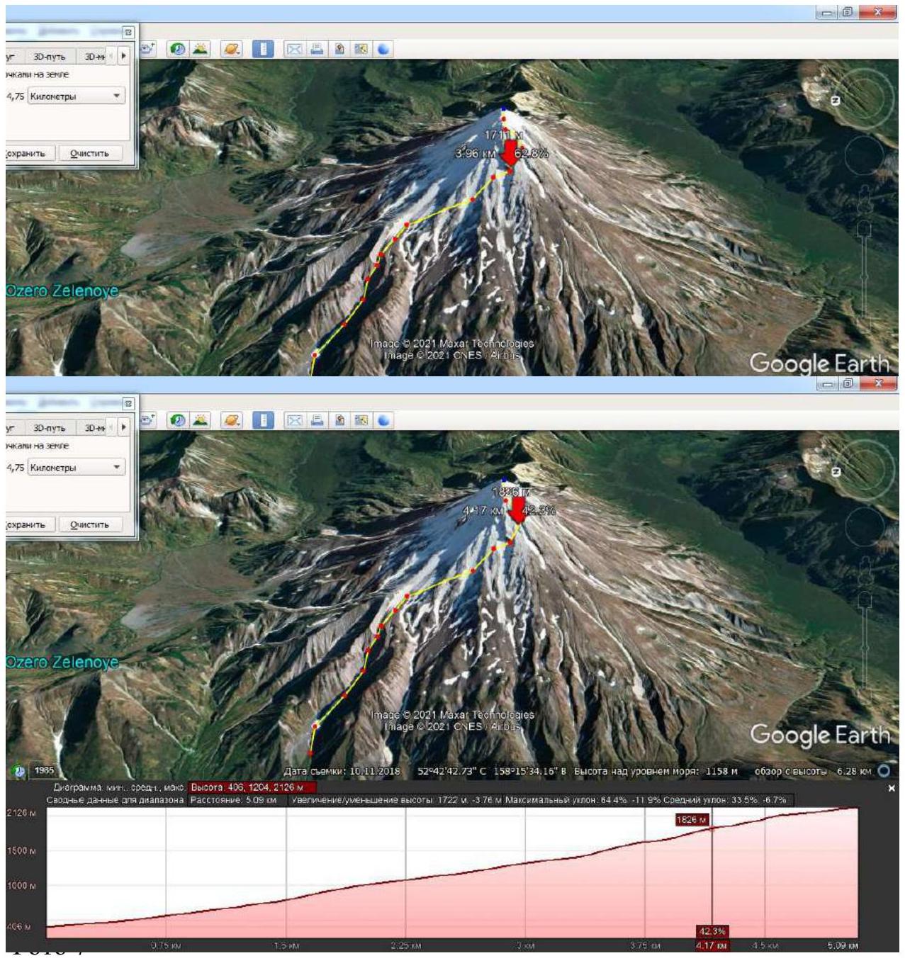
1.2. Route Profile

Image 1. Line (yellow) and profile of the route with characteristics, compiled in Google Earth.
Red line — fragment of route 2A on the NW slope, V. Panchenko (descent line; in the lower part, the routes coincide).

Image 1. Lines of routes; profile of the proposed route
1.3. Cartographic Materials
Images 2–5.
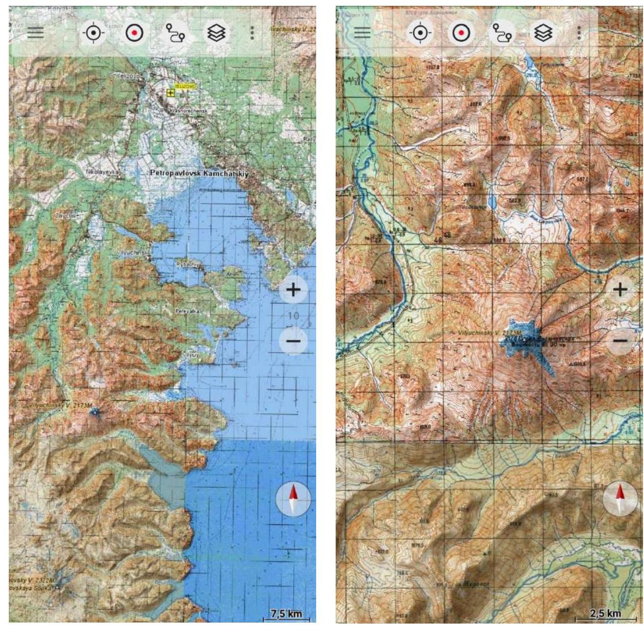

- Yellow line — described route (part of the route behind the ridge)
- Red line — route 2A on the NW slope, V. Panchenko (descent line)
- Black line — approach to the base camp
1.4. Description of the Area. Approach to the Route
Viluchinsky Volcano is located southwest of Petropavlovsk-Kamchatsky, beyond Avachinskaya Bay. It is situated on the watershed of the Vilucha, Bolshaya Sarannaya, and Paratunka rivers.
The volcano is an extinct stratovolcano (formation period — Pleistocene — Holocene, last eruption about 8050 BC), represented by a regular cone with a height of 2175 m above sea level.
The summit of the volcano is truncated to the west and represents large rock remnants separated by a cluster of ice and firn. The slopes of the volcano are cut by radially diverging deep ravines-barankos (some of which originate from the middle of the slope), on the northwest and west slopes filled with ice and firn year-round. A picturesque waterfall is located at the base of the cone, sometimes disappearing in hot years.
The distance from Petropavlovsk-Kamchatsky in a straight line is about 45 km (in clear weather, the volcano is perfectly visible from the city embankment). The path to the start of the route:
- about 45 km on asphalt to the Termalny settlement;
- then about 25 km on a dirt road (technological passage of the Mutnovskaya geothermal power plant and the Asachinskoye deposit) to a left turn on the highway (52°43′43.4″ N, 158°12′40.0″ E);
- on a passable car about 1.5 km to a cleared clearing suitable for a large base camp.
- from the base camp about 1 km to the start of the ascent route (R0).
In snowy conditions, the approach is sometimes made using snowshoes. It should be noted the high avalanche danger of Kamchatka ascents in winter and rockfall danger in late summer.
Currently, there are 3 categorized routes to the summit (Image 6). Route 2A on the NW slope, V. Panchenko, is the descent line from the proposed route; in the lower part (from about 300 m above sea level to about 1000 m above sea level), the routes coincide, then (up to about 2100 m above sea level) they go independently.

Selection of Routes
| № | REGION | DISTRICT | PEAK | ROUTE | h, m | DIFFICULTY | CHARACTER | LEADER | DESCRIPTION |
|---|---|---|---|---|---|---|---|---|---|
| 11 | 3. KAMCHATKA | 3.1. Southern part of the Kamchatka Peninsula | vlk. Viluchinskaya Sopka | from the southeast | 2173 | 2A | k | F. Chelnokov | + |
| 12 | 3. KAMCHATKA | 3.1. Southern part of the Kamchatka Peninsula | vlk. Viluchinskaya Sopka | NW slope | 2173 | 2A | k | V. Panchenko | Description + |
| 13 | 3. KAMCHATKA | 3.1. Southern part of the Kamchatka Peninsula | vlk. Viluchinskaya Sopka | NE ridge | 2173 | 2B | n | A. Gusak | Description + |
Image 6. Routes to the summit on the FAR site
2. Characteristics of the Route
2.1. Route Diagram
The general diagram of the route based on a snapshot in Google Earth is presented (in two scales) in Image 1. The diagram in UIAA symbols is in Image 7.
Image 7. Diagram in UIAA symbols.

| Section | Belay Points | Length, m | Steepness, ° | Difficulty, UIAA |
|---|---|---|---|---|
| R0–R1 | 0 | 1250 | 10–15 | 0 |
| R1–R2 | 0 | 400 | 25 | 0–1 |
| R2–R3 | 1 (ice screw) | 100 | 15 | 0 |
| 50 | 30 | 1 | ||
| R3–R4 | 0 | 500 | 5–10 | 0 |
| R4–R5 | 4+ terrain | 750 | –10–+25 | 2 |
| R5–R6 | 2+ terrain | 350 | 30–40 | 3 |
| R6–R7 | 10 | 200 | 40–50 | 4 |
| R7–R8 | 4+ terrain | 50 | 55 | 4 |
| terrain | 400 | 30–35 | 2 | |
| R8–R9 | 1+ terrain+ice screw | 500 | 25–30+ | 2 |
| R9–R10 | 0 | 250 | 0–10 | 0 |
| terrain | 100 | 15–20 | 0–1 |
2.2. Technical Characteristics of the Route Sections
| Section | Terrain Character | Category of Difficulty | Length, m | Type and Number of Pitons, Movement Technique |
|---|---|---|---|---|
| R0–R1 | Snow-firn gentle slope within a wide, bifurcating couloir. Initially up to 10°, then up to 15°. | 0 | 1250 | Simultaneous movement |
| R1–R2 | On the "fork", movement to the left, along a steeply turning, narrowing couloir. Snow-firn slope. Up to 25°. | 0–1 | 500 | Simultaneous movement, partly with step-kicking by the leader |
| R2–R3 | Expansion of the couloir. Gradual flattening to 15°, then ascent along a firn slope with exit from the couloir (50 m, about 30°, up to 40°) to a wide slope. Simultaneous movement, partly with step-kicking by the leader. At the end of the upper section, belay through an ice screw or terrain may be necessary. | 0 | 100 | Simultaneous movement, partly with step-kicking by the leader. |
| 1 | 50 | |||
| R3–R4 | Snow-firn gentle slope. Movement along the left ridge, then along the snow-firn slope at 5–10°, to the point of logical separation of the proposed route and route 2A on the NW slope by V. Panchenko. | 0 | 500 | Simultaneous movement |
| R4–R5 | Movement along the NW slope (slope-snow collector, feeding the Viluchinsky waterfall) with ascent diagonally, crossing several rocky ridges. Angle of ascent +25–30° (partly up to 35°), descents from the ridges down to –25°. High risk of falling. Simultaneously-alternate movement with step-kicking by the leader. 4 ice screws, belay through terrain. | 2 | 750 | Simultaneously-alternate movement with step-kicking by the leader. 4 ice screws, belay through terrain. |
| R5–R6 | Ascent diagonally along the side of the slope along a series of low rocky ridges separated by wide snowy areas. Angle 30–40°, partly up to 45° or more (high risk of falling). | 3 | 350 | Simultaneously-alternate movement in three steps; with belay through terrain + 2 ice screws |
| R6–R7 | Key 1. Movement traversing along the slope with a slight gain in height, bypassing rocky outcrops from below. Angle of the slope 40–50°, increasing steepness towards the end of the section. High risk of falling. Simultaneous movement with organization of belay on ice screws (8 pcs.). Station on 2 ice screws at point R7. | 4 | 200 | Simultaneous movement with organization of belay on ice screws (8 pcs.). Station on 2 ice screws at point R7. |
| R7–R8 | Key 2. From the end of the traverse, ascent forward and upward along a firn-ice slope (about 50 m, 45–60°) diagonally towards a visible passage between rocky ridges. From the rope, transition to a snow-covered rocky slope (about 400 m, 30–35°), continuing movement diagonally, bypassing the upper rocky ridge, reaching the beginning of a snow-firn couloir. Rope protection on the first section (2 ice screws, 2 anchor pitons, 2 loops, station on a rock) with transition to simultaneously-alternate movement with belay through terrain. | 4 | 50 | Rope protection on the first section (2 ice screws, 2 anchor pitons, 2 loops, station on a rock) |
| 2 | 400 | |||
| R8–R9 | Ascent along firn along a rightward-sloping couloir (25–30°, partly up to 40°), ending in a firn saddle, leading to the next couloir (25–30°), ending in rocky outcrops. Before reaching the rocks, about 150 m, turn right (about 30 m) into a passage between low rocky outcrops, leading to the upper part of the main SW slope couloir (25–30°), exiting onto a large pre-summit saddle. Simultaneous or simultaneously-alternate movement with step-kicking by the leader. 1 ice screw, 2 loops, belay through ice screws and terrain. | 2 | 500 | Simultaneous or simultaneously-alternate movement with step-kicking by the leader. 1 ice screw, 2 loops, belay through ice screws and terrain. |
| R9–R10 | Movement to the right along the saddle (250 m, 0–10°) towards the rocky snow-covered summit, then ascent along simple snow-covered rocks (about 100 m, 15–20°), with belay through terrain if necessary. | 0 | 250 | Simultaneous movement; with belay through terrain if necessary |
| 0–1 | 100 |
3.1. Brief Description of the Route Passage
| Section | Description | Photo Number |
|---|---|---|
| R0–R1 | Snow-firn gentle slope, length about 1250 m. Up to 10°, then up to 15°. Simultaneous movement. | |
| R1–R2 | On the "fork", movement to the left, along a steeply turning, narrowing couloir. Snow-firn slope, length up to 500 m. Up to 25°. Simultaneous movement, partly with step-kicking by the leader. | |
| R2–R3 | Gradual flattening to 15° (about 100 m), then ascent along a firn slope with exit from the couloir (50 m, about 30°, up to 40°) to a wide slope. Simultaneous movement, partly with step-kicking by the leader. At the end of the upper section, belay through an ice screw or terrain may be necessary. | Image 8 |
| R3–R4 | Snow-firn gentle slope, length about 500 m. Simultaneous movement, initially along the left ridge, then to the point of logical separation of the proposed route and route 2A on the NW slope. Initially 5–10°, then up to 15°. | |
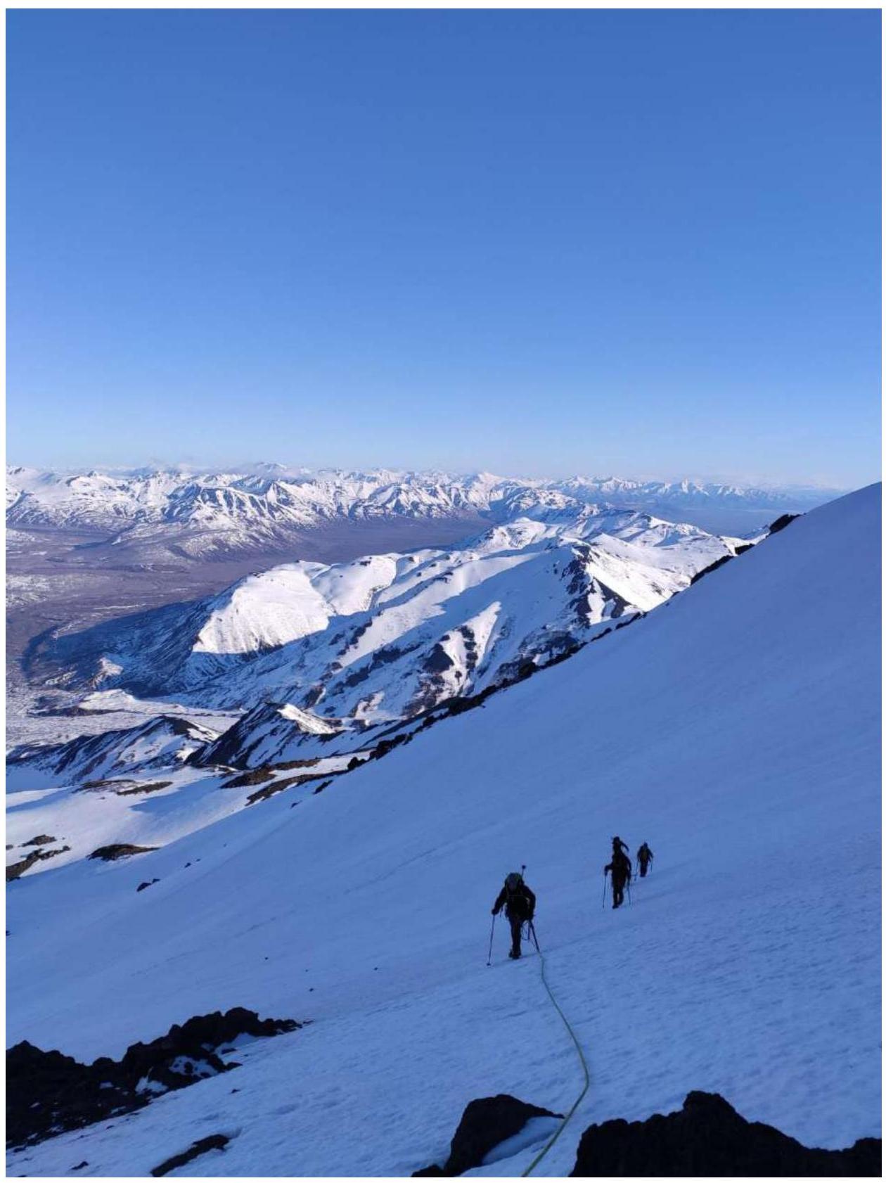
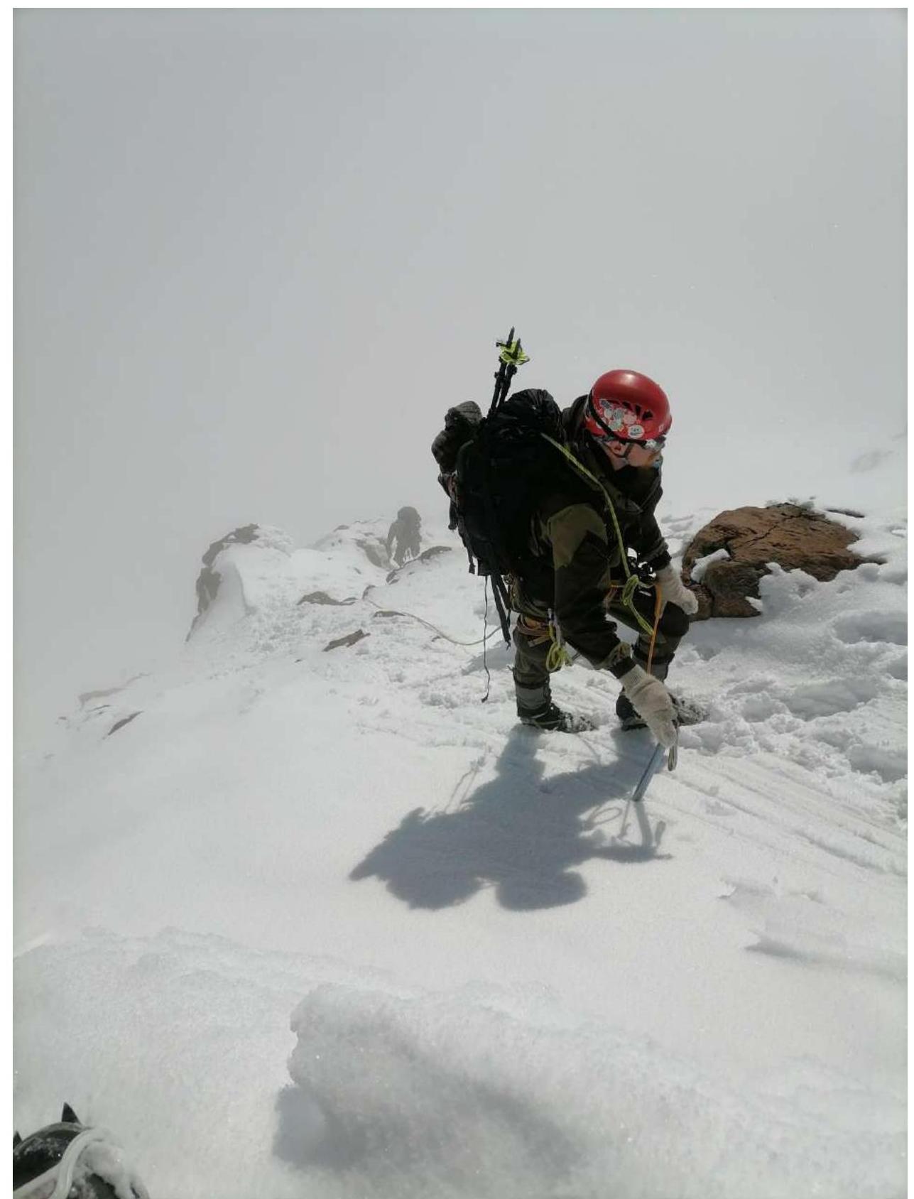
| R4–R5 | Movement about 750 m with ascent diagonally along the NW slope, crossing several rocky ridges. Angle of ascent +25–30° (partly up to 35°), descents from the ridges down to –25°. High risk of falling. Simultaneously-alternate movement with step-kicking by the leader. 4 ice screws, belay through terrain. | Photo 5 |
| R5–R6 | Ascent diagonally along the side of the slope, 350 m, along a series of low rocky ridges separated by wide snowy areas. Angle 30–40°, partly up to 45° or more (high risk of falling). Simultaneously-alternate movement in three steps; with belay through terrain + 2 ice screws. | Image 9 |
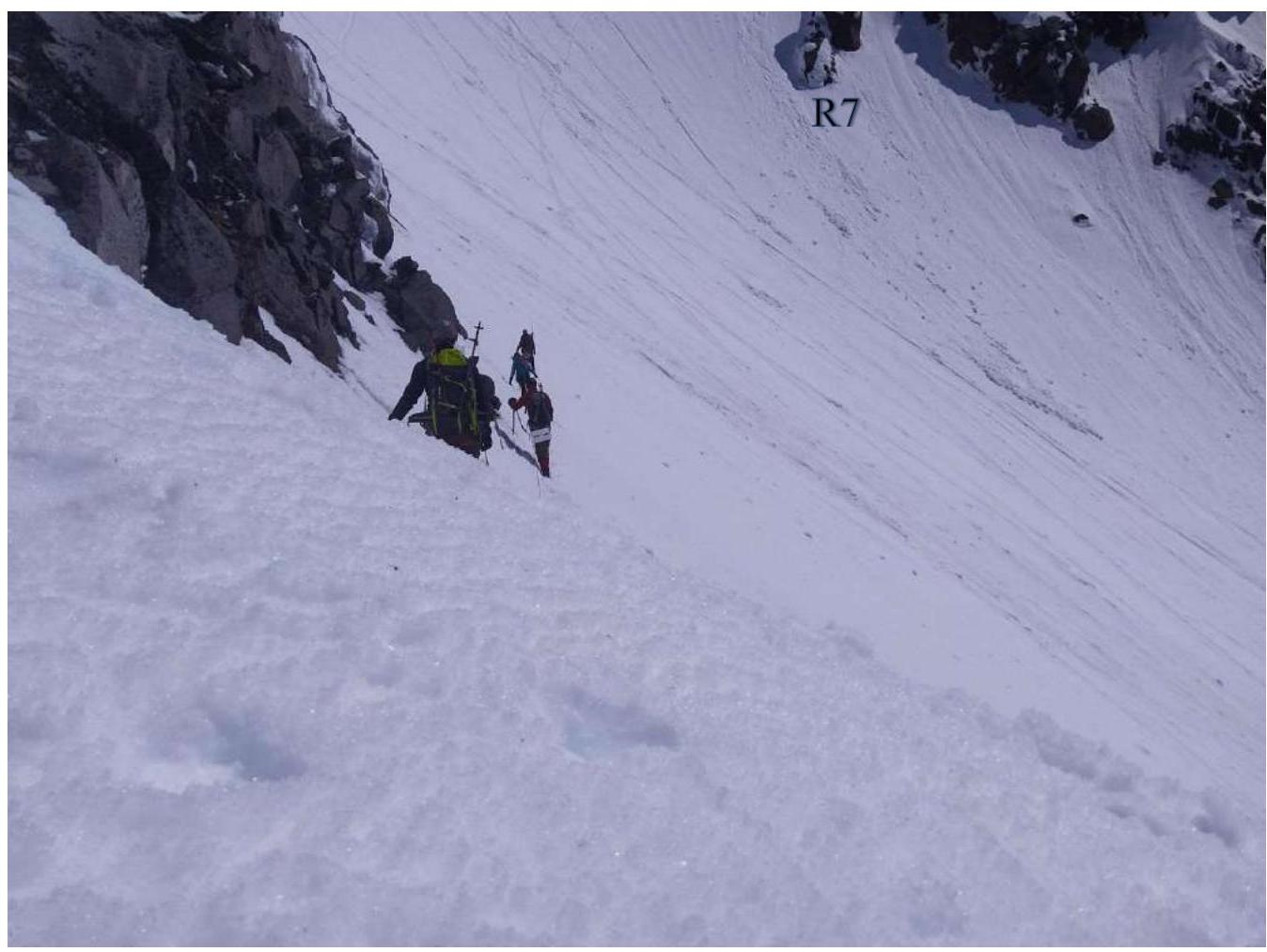
| R6–R7 | Key 1. Movement 200 m traversing along the slope with a slight gain in height, bypassing rocky outcrops from below. Angle of the slope 40–50°, increasing steepness towards the end of the section (high risk of falling). Simultaneous movement with organization of belay on ice screws (8 pcs.). Station on 2 ice screws at point R7. | Photo 6 |
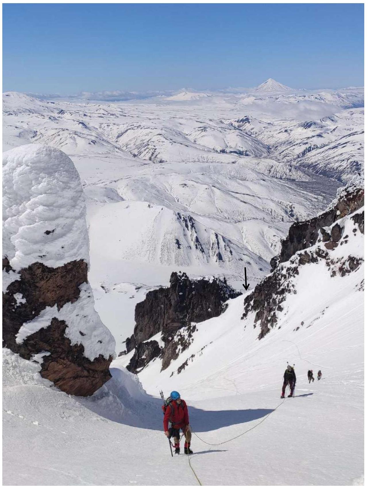
| R7–R8 | Key 2. From the end of the traverse, ascent forward and upward along a firn-ice slope (about 50 m, 45–60°) diagonally towards a visible passage between rocky ridges. Then transition to a snow-covered rocky slope (about 400 m, 30–35°), continuing movement diagonally, bypassing the upper rocky ridge, reaching the beginning of a snow-firn couloir. Rope protection on the first section (2 ice screws, 2 anchor pitons, 2 loops, station on a rock) with transition to simultaneously-alternate movement with belay through terrain. | Images 10, 11; Photo 7 |
| R8–R9 | Length of the section about 500 m. Ascent along firn along a rightward-sloping couloir (25–30°, partly up to 40°), ending in a firn saddle, leading to the next couloir (25–30°), ending in rocky outcrops. Before reaching the rocks, turn right into a passage between low rocky outcrops, leading to the upper part of the main SW slope couloir (25–30°), exiting onto a large pre-summit saddle. Simultaneous or simultaneously-alternate movement with step-kicking by the leader. 1 ice screw, 2 loops, belay through ice screws and terrain. | Image 12; Photo 8 |
| R9–R10 | Simultaneous movement to the right along the saddle (250 m, 0–10°) towards the rocky snow-covered summit, then ascent along simple snow-covered rocks (about 100 m, 15–20°), with belay through terrain if necessary. | Photo 9; Photo 10 |
3.2. Brief Description of Individual Sections with Accompanying Materials
Section R2–R3
Gradual flattening to 15° (about 100 m), then ascent along a firn slope with exit from the couloir (50 m, about 30°, up to 40°) to a wide slope. Simultaneous movement, partly with step-kicking by the leader. At the end of the upper section, belay through an ice screw or terrain may be necessary.
Image 8.

Movement about 750 m with ascent diagonally along the NW slope, crossing several rocky ridges. Angle of ascent +25–30° (partly up to 35°), descents from the ridges down to –25°. High risk of falling. Simultaneously-alternate movement with step-kicking by the leader. 4 ice screws, belay through terrain.
Photo 5.
Section R5–R6
Ascent diagonally along the side of the slope, 350 m, along a series of low rocky ridges separated by wide snowy areas. Angle 30–40°, partly up to 45° or more (high risk of falling). Simultaneously-alternate movement in three steps; with belay through terrain + 2 ice screws.
Image 9.

Key 1
- Movement 200 m traversing along the slope with a slight gain in height, bypassing rocky outcrops from below.
- Angle of the slope 40–50°, increasing steepness towards the end of the section (high risk of falling).
- Simultaneous movement with organization of belay on ice screws (8 pcs.).
- Station on 2 ice screws at point R7.
Photo 6.
Key 2
- From the end of the traverse, ascent forward and upward along a firn-ice slope (about 50 m, 45–60°) diagonally towards a visible passage between rocky ridges.
- Then transition to a snow-covered rocky slope (about 400 m, 30–35°), continuing movement diagonally, bypassing the upper rocky ridge, reaching the beginning of a snow-firn couloir.
- Rope protection on the first section (2 ice screws, 2 anchor pitons, 2 loops, station on a rock) with transition to simultaneously-alternate movement with belay through terrain.
Images 10, 11; Photo 6, 7.
Images 10, 11
Section R8–R9
Length of the section about 500 m. Ascent along firn along a rightward-sloping couloir (25–30°, partly up to 40°), ending in a firn saddle, leading to the next couloir (25–30°), ending in rocky outcrops. Before reaching the rocks, turn right into a passage between low rocky outcrops, leading to the upper part of the main SW slope couloir (25–30°), exiting onto a large pre-summit saddle. Simultaneous or simultaneously-alternate movement with step-kicking by the leader. 1 ice screw, 2 loops, belay through ice screws and terrain.
Image 12; Photo 8.
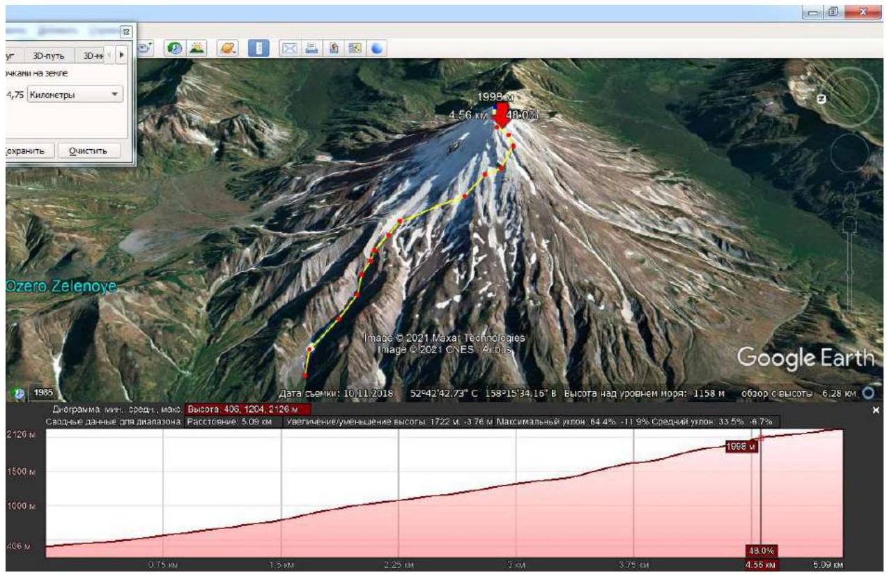
Photo 8. Shows the "saddle" in the middle of the section.
Section R9–R10
- Simultaneous movement to the right along the saddle (250 m, 0–10°) towards the rocky snow-covered summit.
- Ascent along simple snow-covered rocks (about 100 m, 15–20°), with belay through terrain if necessary.
Photo 9, 10.
Photo 9

Photo 10. Group on the summit.

3.3. Conclusions. Safety Assessment of the Route. Recommendations for Subsequent Climbers
The proposed category of difficulty is correlated with similar routes on:
- Kamchatka (Vulcan Viluchinskaya Sopka, Kozelsky Volcano, and Koryaksky Volcano)
- Arkhyz (Dimitrov-100, Orlyonok)
- Badzhal Ridge in Khabarovsk Krai, previously climbed by the team members proposing the route.
Overall, the route is logical and readable, including in conditions of partially limited visibility.
It is essential to note that the route affects slopes and couloirs of several exposures, requiring special attention to avalanche danger control, especially after heavy snowfalls and during the off-season. It is recommended to climb the route only with a stable snow cover and with avalanche equipment.
From early July to late September, the firn on the route may be partially melted, which can cause difficulties with belay using ice screws. During this time, there is also a high risk of rockfall on some sections of the route with a slope of 40° or more (for comparison of snow cover conditions, see Photo 2 (May 2021) and Photo 4 (August 2021)).
Descent from the summit is recommended via route 2A on the NW slope, V. Panchenko, keeping in mind that it includes a firn-ice, potentially rockfall-prone "bottle" section up to 30 m long and with a slope of up to 40–45° in the upper part of the descent line (circled in black on Photo 3).
If there is fresh snow on the approaches, it is recommended to use snowshoes.


