
DESCRIPTION
The route of traversing the Shah-Dag peak massif from east to southwest with ascent via the eastern counterfort, accomplished by a team of climbers from the Azerbaijan Council "DINAMO" during an expedition from October 30 to November 10, 1966.
The Shah-Dag peak is located in the Lateral Ridge of the Eastern Caucasus within the territory of the Azerbaijan SSR and has an elevation of 4250 m (other sources indicate 4255 m).
The main massif of the peak drops steeply to the south and southwest towards the wide left-bank terrace of the Shahnabad River (towards "Shah-Eylag") with steep walls, the lower part of which is a 400-600 m monolithic cliff. The upper part of the walls has a stepped structure, composed of individual 20-40 m monolithic blocks dissected by narrow couloirs and crevices, and merges into the massive ice-snow dome of the peak, with individual heavily destroyed ridges and rock ridges cutting into it.
The slopes of the dome have a considerable steepness of 40-45° in the lower part and, gradually becoming less steep towards the top, form a snow-covered summit plateau of significant extent. The summit point is closer to the southern part of the plateau, at the beginning of the rocky ridge extending in the direction of the southern wall.
To the east, the summit dome also drops with monolithic rocky cliffs, gradually becoming less steep in the northern part and transitioning into heavily destroyed, scree-covered eastern slopes of the ridge extending from the peak to the northeast.
From the southeastern part of this slope, four parallel ridge-spurs of cuesta-like form extend eastward, with slopes dropping steeply to the south and significantly more gently to the north.
- The highest, southernmost spur, forms the southeastern continuation of the southern wall of the massif with its cliffs.
- The northern spur is the longest and divides into two branches, sharply turning to the north and south.
- The northern branch, merging with the northeastern ridge of the peak, forms a large cirque, which is snow-free in summer and covered in stone scree.
Several steep, short counterforts of block-like structure extend from the eastern cliffs of the massif into this cirque, between which small hanging glaciers and snowfields hang from the summit dome.
Currently, there is a single classified route to the summit of Shah-Dag, rated as Category 1B: exit from Shah-Eylag into the cirque through the saddle in the northernmost of the eastern spurs (known as the "Kursantsky" pass), ascent via a couloir to the northeastern ridge, and exit along the ridge to the summit dome. Descent is via the ascent route.
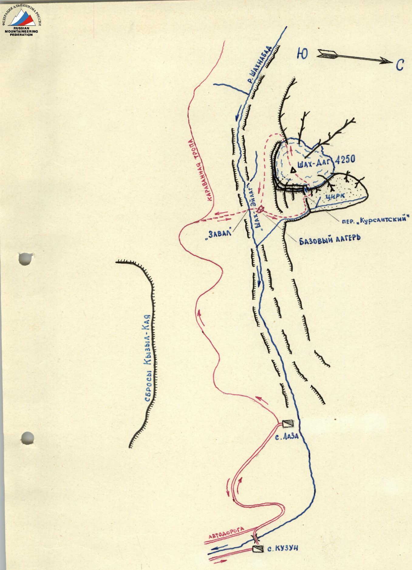
FIG. 1. Map-scheme of the Shah-Dag peak massif area
- Approach and traverse route
- Bivouacs
A longer and extremely interesting route is further advancement from the summit point to the southwest, crossing the entire summit plateau, and descending from the dome first along the ridge and then via a couloir (i.e., traversing the entire massif generally from north to south), previously classified as Category 2A, but not included in the current classification table.
The most accessible path to overcome the eastern cliffs of the peak from the cirque side appears to be a narrow couloir cutting through the cliffs in the southern part of the cirque. However, this couloir leads to the base of the last step of the southeastern cliffs of the peak, which is completely vertical and monolithic, and down which water flows from the snow dome of the peak during warm times.
The counterfort located to the right of the couloir represents a jumble of block-steps with places having very wide balconies littered with rock debris. In the upper part, the counterfort is sharply dissected by a deep gap, from which a narrow couloir-inner angle descends, dropping over the second step of the counterfort. This gap can be used to exit onto the upper step of the eastern cliffs of the massif.
On November 8, 1966, a group of climbers from the Azerbaijan Council "DINAMO" consisting of:
- O.S. Drozdovsky - leader;
- O.M. Tereshchenko;
- T.G. Selimkhanov;
- I.M. Mirzoyev - participants, set out at 3:00 from a bivouac located under the southern wall of the peak (at "Shah-Eylag").
Having passed through the saddle (Kursantsky pass) by 5:15 and laid a trail with almost no loss of height along the snowy slope of the cirque, the group approached the entrance to the couloir by 6:00 and began ascending through the snow on the right-hand side of the couloir under the cover of rocks. The couloir, initially not very steep, is blocked at the point of narrowing by a steep, hump-like ice formation. Overcoming the icy rise on crampons and driving in an ice axe for protection, the group continued the ascent along the couloir to the level of a ledge girdling the counterfort above the first, lowest block of the counterfort. The ledge, generally not wide, has individual expansions - balconies - in places and is covered with ice-cemented rocks. The exit from the couloir onto the ledge is not complicated.
Exiting the couloir to the right and upwards onto the ledge and skirting the counterfort along the ledge (movement is almost everywhere simultaneous), the group approached the foot of a not clearly defined outer angle formed by the convex bend of the wall of the second step of the counterfort (further movement along the ledge is dangerous as it will be under the couloir drop located above).
The ascent along the outer angle of the wall (2-2.5 ropes) to the second step of the counterfort represents the most difficult section of the route due to significant steepness (60-70°) and weak rock articulation (small holds and a very small number of cracks for protection). The cracks are narrow, requiring the use of thin petal hooks. During the passage of this section:
- 3-step ladders were used 4 times.
- All backpacks were pulled up on a rope.
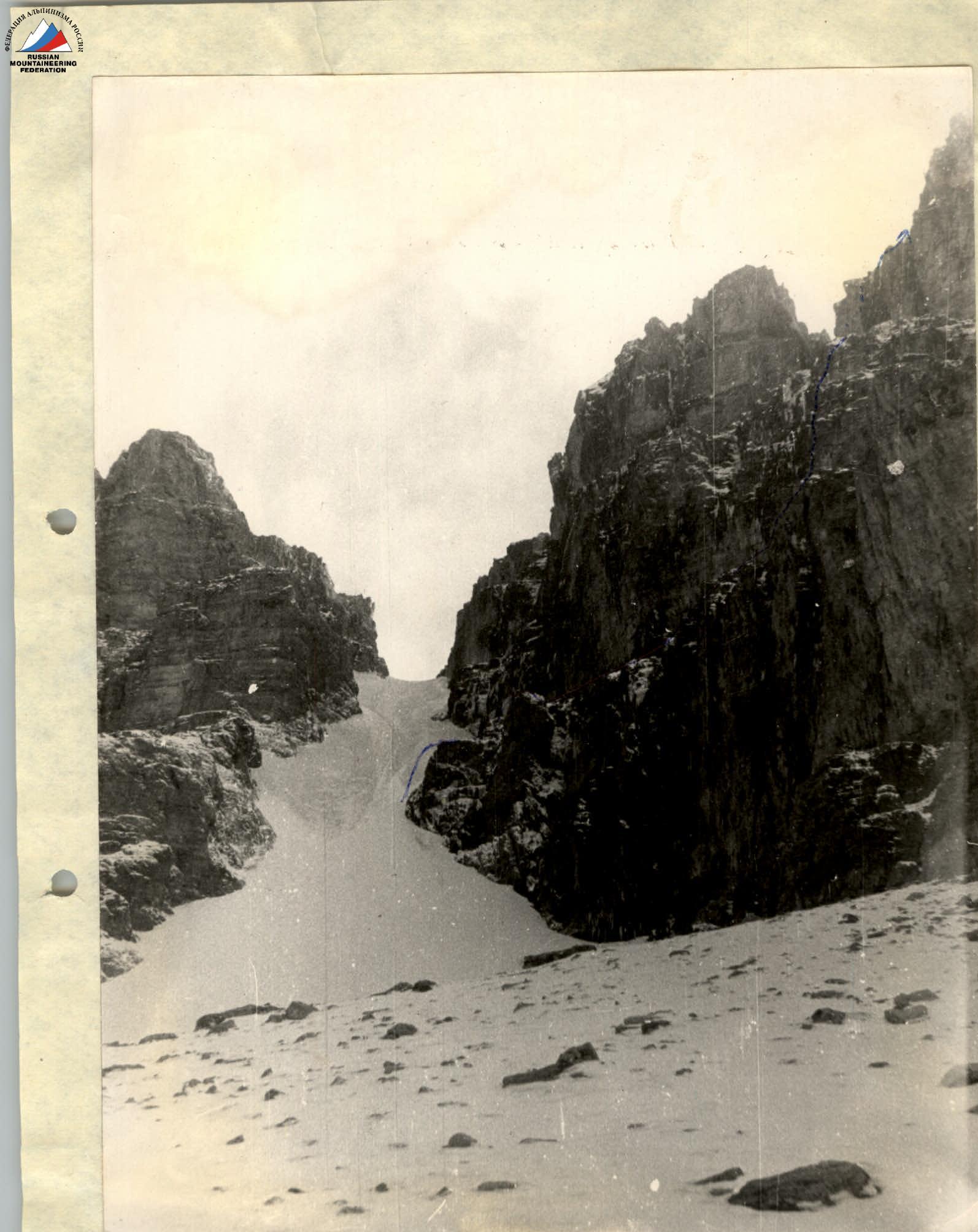
PHOTO 2. View of the couloir in the eastern cliffs of Shah-Dag peak (from the cirque).
Having spent about three hours overcoming this section, the group reached the upper part of the second step of the counterfort by 11:00, to the left of the couloir descending from the gap. Here, a control cairn was left on the rocks.
From the control cairn, the group's ascent proceeded along the rocks of the left-hand side of the couloir (the easier path of ascent - directly along the couloir - is rockfall-prone). The rocks are generally not steep, of medium difficulty, heavily dissected into individual block-steps with a large number of protrusions for protection. To overcome individual small monolithic walls 2-2.5 m high, "boosting" was used. However, progress was significantly slowed due to the need for:
- constant clearing of rocks from ice and snow;
- cutting steps.
By 13:00, the group, having passed the gap, reached the upper step of the counterfort. Having ascended along the not very steep, heavily destroyed rocks of the upper part of the counterfort and the ridge extending upwards from it, the group reached the slope of the peak's dome.
The steep lower part of the dome - an icy slope with a steepness of 40-45°, extending for about three ropes - was overcome on the front points of crampons with ice axe protection (6 ice axes). Further along the gradually flattening icy and then snowy slope, the group reached the summit of the dome. Progress was greatly hindered by a strong headwind with drifting snow and deep, loose snow in the summit part of the dome. Around 15:00, the group reached the summit cairn on a snow-covered rocky ridge, where two busts of V.I. Lenin were placed on a large pyramid made of stones.
From the summit cairn, in very poor visibility, the group, maintaining a southwest direction, crossed the southern part of the summit plateau with a small depression and reached a scree ridge (a tall cairn was built here as a landmark), from which they began descending down the slope of the dome. For the descent on the last steep section, a rope was used (2 ice axes). Further, in conditions of a starting heavy snowfall, along a destroyed ridge, then along a snowfield and scree, the group descended to Shah-Eylag and, bypassing the Shah-Dag massif from the south, returned to the original bivouac by 20:00.
The entire route from bivouac to bivouac took 17 hours. The total height difference of the route (by barometer) was about 2200 m. On the route, the following were used:
- 9 ice axes;
- 12 rock anchors (4 of which were used as artificial holds).
The route is extremely interesting both in terms of the combination of rock, ice, and snow relief elements and in the combination of rock sections of medium difficulty with short sections of very difficult climbing. Overall, in terms of technical difficulty and length, the route (in summer conditions) corresponds approximately to Category 3B.

PHOTO 4. Ascent along the couloir from the control cairn.
Time calculation (for summer period):
- Bivouac on Shah-Eylag, saddle - entrance to the couloir: 3 hours.
- Ascent along the counterfort: 5-6 hours.
- Ascent to the dome - summit: 2-3 hours.
- Traverse of the massif and return to bivouac: 4-5 hours. Total: 14-17 hours.
NOTE: In the case of descent from the summit via the Category 1B route (without traversing the massif), the route can be rated as Category 2A.
To complete the route, it is necessary to have:
- 2-3 ice axes;
- 6-8 rock anchors (3-4 of which must be petal-type);
- 1-2 pcs. 2-3-step ladders or stirrups.
Due to the length of the route, the possibility of a bivouac on the route should be considered. Possible overnight locations: in the gap at the top of the counterfort, near the summit, and on the ridge after descending from the dome.
Ascent leader: O. Drozdovsky Participants:
- O. Tereshchenko
- T. Selimkhanov
- I. Mirzoyev
Comments
Sign in to leave a comment