
ASCENT DOCUMENT FIRST ASCENT
- The route is ice-rock
- 2.96 – Dagestan mountains (Eastern Caucasus)
- Ascent to peak Tunsada, 4013 m, from the North-Eastern Addala glacier and along the Western ridge
- Proposed difficulty category – 2B
- Route characteristics:
- length – 930 m
- total elevation gain – 400 m
- average slope – 40°
- length of categorized sections:
- Category I – 490 m;
- Category II – 290 m;
- Category III – 150 m.
- Pitons driven:
- ice – 3
- rock – 2
- Time spent on the route – 9 hours
- No overnight stay on the route
- Participants and their sports qualification:
- Aliev Shamakhal Ramazanovich – 1st sports category, leader
- Gamzaev Badrutdin Gadzhievich – 2nd sports category.
- Coach – Pashchuk E.G.
- Date of departure and return – August 26, 1986
- Organization: State Sports Committee of the Dagestan ASSR.
BRIEF CHARACTERISTICS OF THE PEAK.
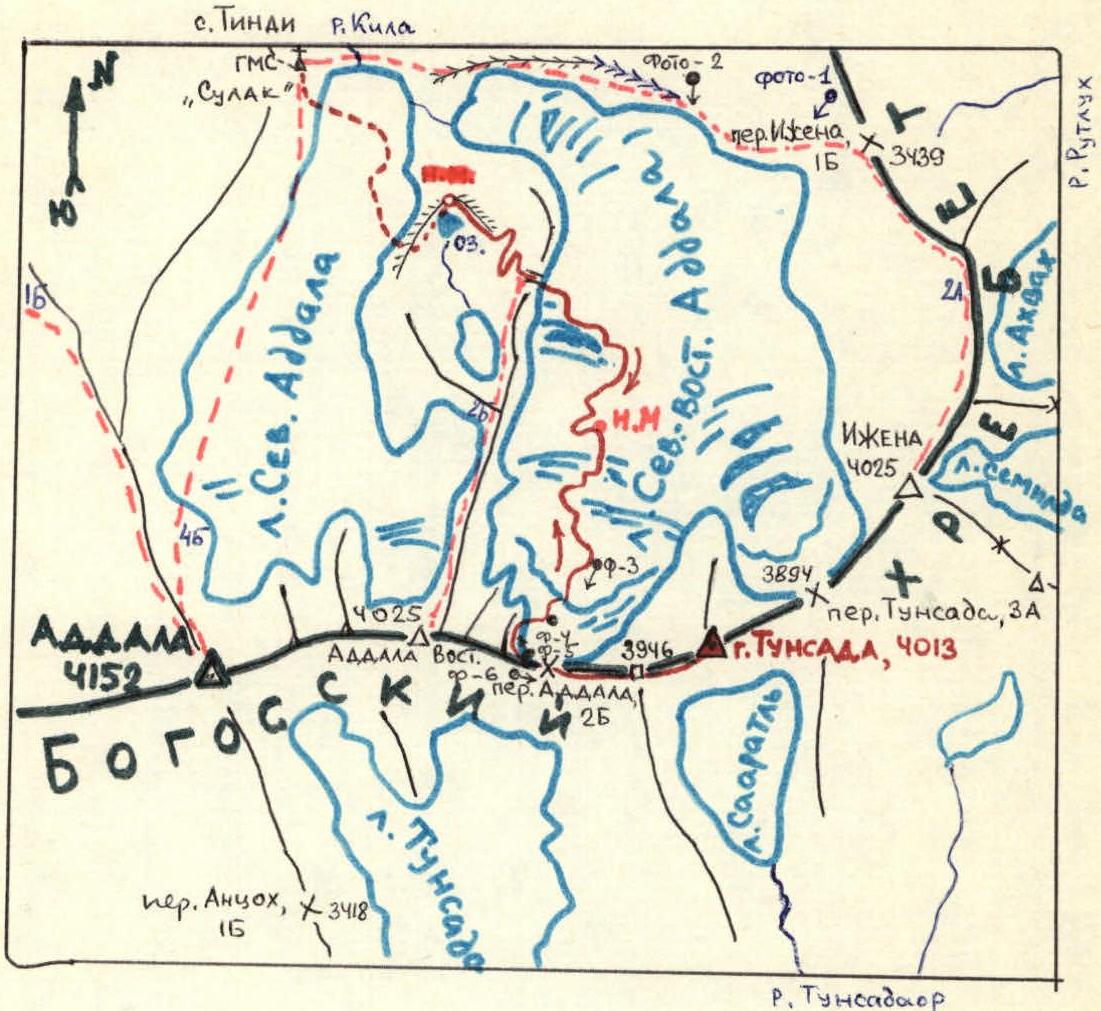
The ice-rock peak Tunsada is located in the Bogossky ridge to the east of peak Addala. Along the Bogossky ridge, Tunsada is bounded by the Addala pass (2B) to the west and the Tunsada pass (3A) to the east. The northwestern rock wall of Tunsada drops to the North-Eastern Addala glacier with cliffs up to 400 meters. The glacier serves as the source of the Kila river, a right tributary of the Andiyskoe Koysu. To the south flows the Saaratl glacier, and to the southwest – the Tunsada glacier. Both glaciers are the source of the Tunsadaor river, a right tributary of the Cherakh river (basin of the Avar Koysu).
The neighboring peaks to Tunsada are Addala Eastern (4025 m) to the west and Izhena (4025 m) to the northeast. Until 1986, the peak had not been climbed by anyone. The only attempt to ascend was made in 1980 (led by K. Akhmedkhanov, Zelenograd). The group ascended from the north to the Addala pass (3872, 2B), but due to lack of time, they stopped the ascent.
The nearest peaks with established routes are:
- Addala (1B, along the NW ridge, 4B along the central spur of the NE wall);
- Addala East (2B along the N spur);
- Izhena (2A along the N ridge).
APPROACH TO THE ROUTE.
From the Aglali rural center by bus to the village of Tindi (15 km). Then along the trail, which follows both banks of the Kila river, to the village of Aknada (8 km, 1 hour).
From Aknada:
- initially through the canyon;
- then through the Kila gorge to the Tsobegodari meadow, 2060 m, on the right bank of the Kila (6 km, 1 hour).
At the Tsobegodari pasture, cross to the left bank of the Kila and follow the trail with a steep ascent to the "Sulak" high-altitude meteorological station, 2953 m. From Tsobegodari – 5 km, 1.5–2 hours.
From the "Sulak" meteorological station, proceed to the Northern Addala glacier, crossing its tongue diagonally and ascending to the right-bank moraine. Below the moraine lies a small Shukhgel lake (3021 m). From the meteorological station – 0.7 km, 30 minutes.
After ascending to the moraine of the North-Eastern Addala glacier, proceed under the rocky-debris slope of the northern spur of peak Addala East. Ascend via broken rocks and steep scree to the saddle on the spur.
From the saddle, a small plateau on the North-Eastern Addala glacier is visible. The plateau is crossed in the direction towards the northern wall of peak Tunsada. Here begins the route.
ROUTE DESCRIPTION
The route begins with an ice ascent (II; 140; 100°), bypassing icefall 1. Then, along an ice slope (II; 150; 35°), icefall 2 is bypassed to the right. Higher up, the steepness of the ice increases sharply, and an exit under the bergschrund is made, which cuts across the entire glacier from peak Tunsada to peak Addala East. After crossing the bergschrund, ascend via ice (III; 120; 55°; 3 ice pitons) and broken rocks to above the saddle (III; 30; 50°). On the saddle, there are snow cornices. Cairn. From the start of the route, 3 hours. From the pass, along the rocky western ridge to the Western shoulder (3946 m), from where along the broken ridge (I; 490; 30°), exit to the summit. From the Addala pass, 1 hour 30 minutes. Descent is made along the ascent route. Total ascent time is 7 hours.
ROUTE SCHEME TO PEAK TUNSADA.
Scale 1 cm ~ 210 m
S.P. – start point
— icefalls
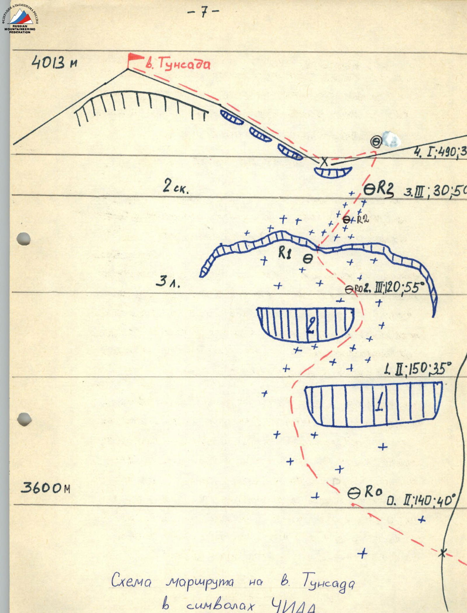
Route scheme to peak Tunsada in UIAA symbols
Photo-3. The Addala pass is near. August 26, 1986, 9:00. Section R2–R4. Shooting point 3. "Industar 50".
Comments
Sign in to leave a comment