
ASCENT REPORT
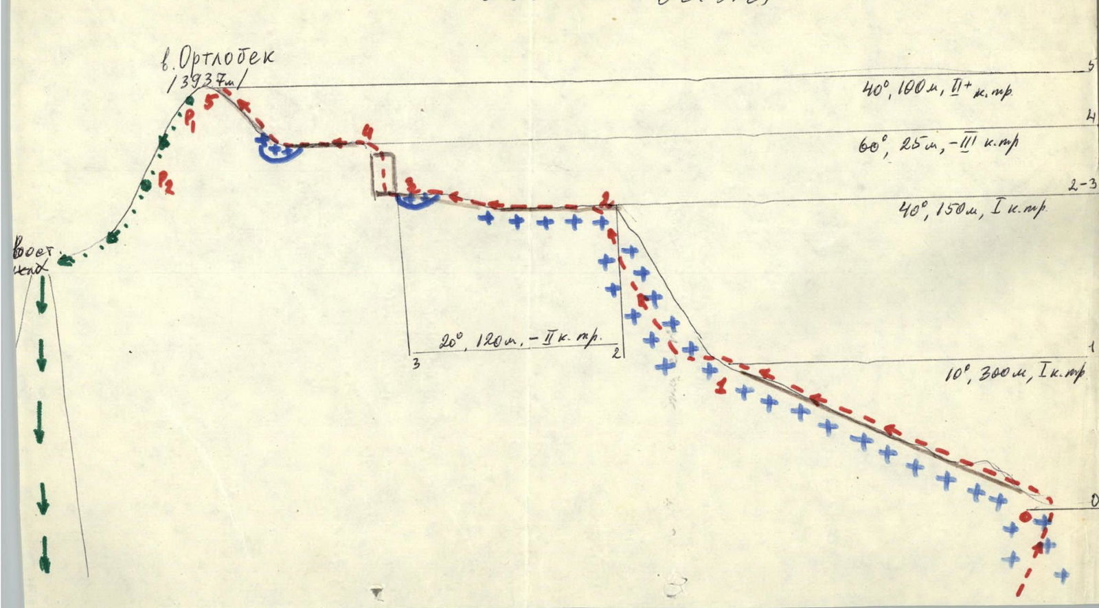
I. Climbing area: 2.9.Б, Dagestan Mountains 2. Climbing class: combined 3. Peak, its height: Ortlobak, 3937 m 4. Ascent route: via the southern ridge 5. Estimated difficulty category: 2А, 18 m, 54605 29/1–85 6. Route characteristics: height difference — 400 m, steepness — 30°, length of sections 1st cat. diff. — 450 m, 2 — 220 m, 3 — 20 m
- Pits were not used
- Overnight stay in the base camp
- Surname I.O. of the leader and participants, their sports qualification
| Surname I.O. | Qualification |
|---|---|
| Timoshin M.E. | MS |
| Kudryavtsev A.I. | 2nd sports category |
| Kozorezov E.F. | 2nd sports category |
| Leonov P.G. | 2nd sports category |
| Yakhyaev R.K. | 2nd sports category |
| Musaev A.A. | 3rd sports category |
- Date of ascent: November 10, 1977 II. Team coach: MS Timoshin M.E.
NOTE: A note from climbers from Kaspiysk dated May 6, 1977 was found at the summit. Team leader Amirkhanov A.
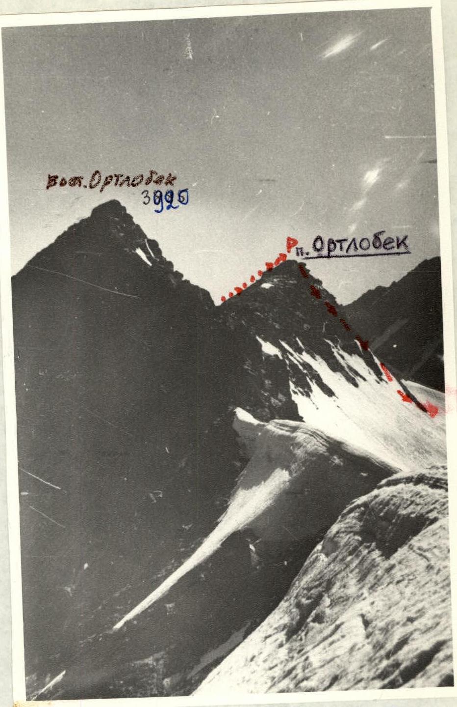
- Ortloek, view from the south, from the cirque, November 1977. FED "Mikron" camera.
Brief characteristics of the peak
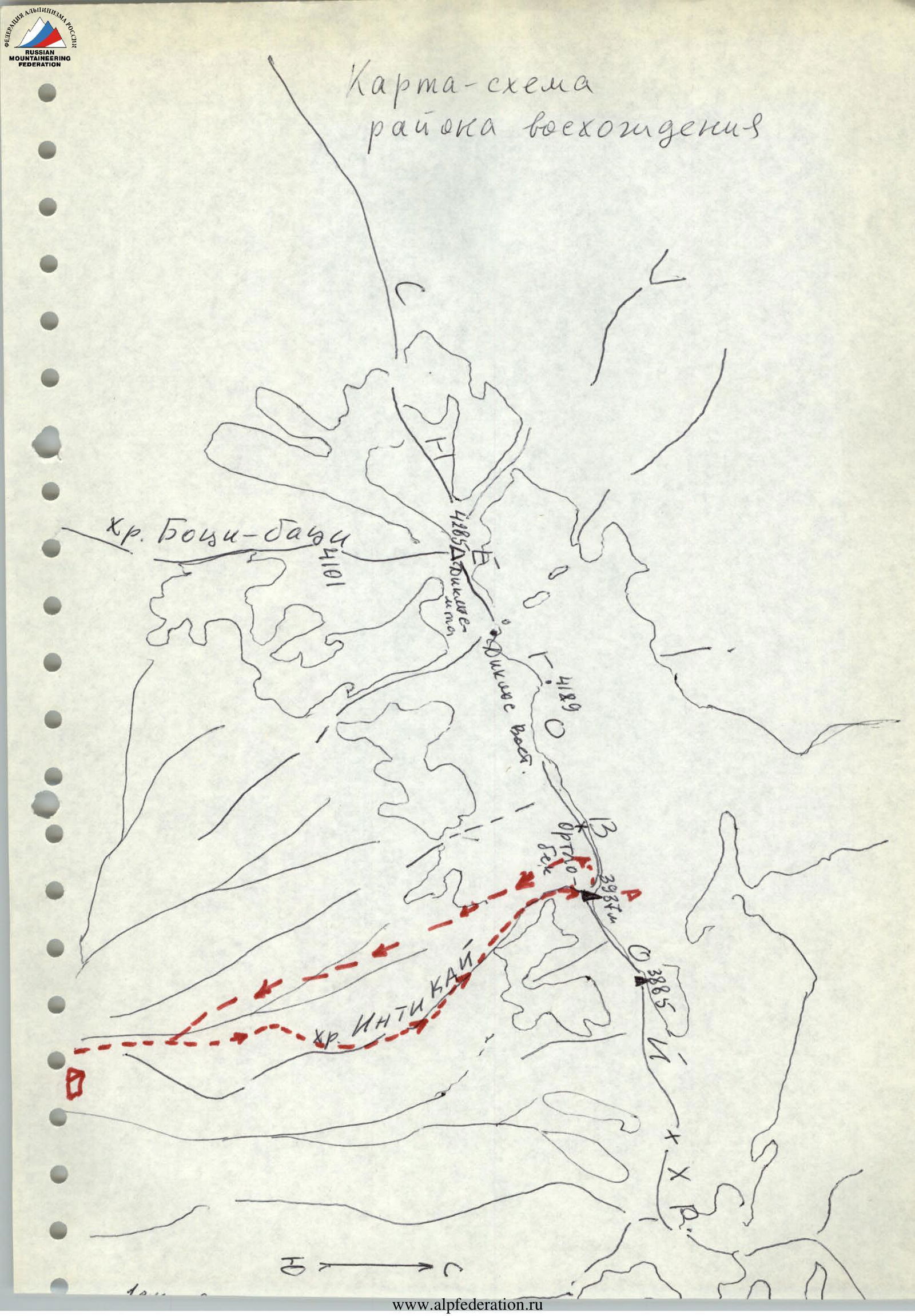
Mount Ortloek (3937 m) is located in the Snow Ridge to the east of the Diklosmta massif and is separated from it by the East Diklos pass. The massif is composed of shale and consists of two peaks – Western and Eastern (3885 m). The peak drops steeply to the north and southwest with shale walls; to the east and south, it has long, sharp ridges. The described route follows the southern ridge. The first known ascent to Mt. Ortloek was made by climbers from Makhachkala in July 1971, when a group led by K. Akhmedkhanov traversed both peaks of Ortloek from west to east.
Description of approaches to the base camp and route
One can reach the district center of Tsumadinsky district, Agvali, by bus from Makhachkala or by hitchhiking from Grozny via Kharami pass. From Agvali to Sildi, there is a dirt road. Without going up to Sildi, turn left and follow the trail along the Gakko River to the eponymous village (1.5–2 hours).
From Gakko:
- follow the right (in the direction of travel) bank of the river;
- then via a dirt road 3–4 hours to a clearing at the confluence of the Gakko and Nisliya rivers (about 2400 m).
Here are good sites for a base camp.
Next, it is necessary to ascend to the Diklos cirque, turning from the clearing to the right and climbing the grassy slopes to the terminal lateral moraine of the Diklos-3 glacier (see the area diagram). From the clearing — 1.5–2 hours. From the moraine, climb to the right onto the rocky ridge of the Intikai ridge and follow it to the snow cirque. From the base camp — 4.5–5 hours of walking lightly.
Route description
The route starts in the snow cirque, where the Intikai ridge leads. From the cirque, follow a gentle ridge to the scree slope, which leads to the pre-summit ridge with three snowy saddles (cornices!).
- After the second saddle — 20 m steeply up through snow-covered shale rocks (perils).
- After the third saddle, reach the pre-summit rocks via a wide scree ridge.
At the summit — a cairn. From the start of the route, 2 hours 30 minutes.
Descent:
- northwest to the East Diklos pass (2 sports descents);
- then down the snowy slope to the pass saddle;
- further south along a steep couloir to the Diklos cirque.
Descent to the base camp — 2.5 hours. Total — from the base camp 9–10 hours for a group of 6–8 people.
On sections R2–R5, travel in rope teams. Equipment — standard.
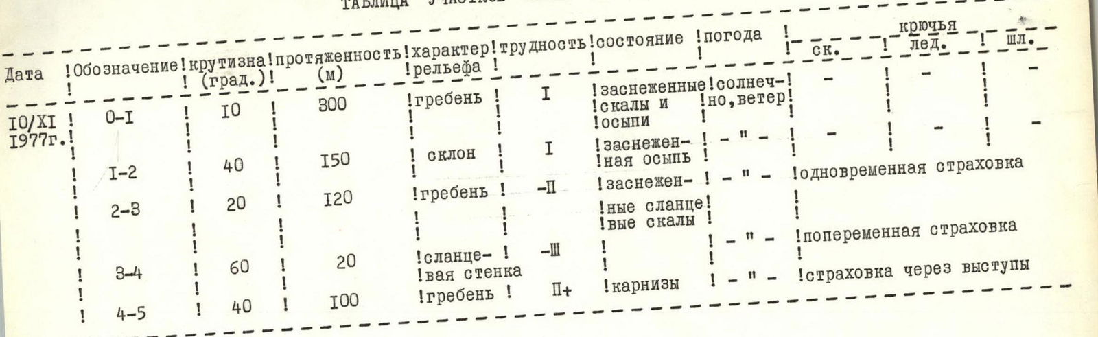
Route sections table
| Date | Designation | Steepness (degrees) | Length (m) | Terrain characteristics | Difficulty | Condition | Weather | Belaying |
|---|---|---|---|---|---|---|---|---|
| November 10, 1977 | R0–R1 | 10 | 300 | Ridge | 1 | Snow-covered rocks and scree | Sunny, windy | — |
| November 10, 1977 | R1–R2 | 40 | 150 | Slope | 1 | Snow-covered scree | — | — |
| November 10, 1977 | R2–R3 | 20 | 120 | Ridge | 2 | Snow-covered shale rocks | — | Simultaneous belaying |
| November 10, 1977 | R3–R4 | 60 | 20 | Shale wall | 3 | — | — | — |
| November 10, 1977 | R4–R5 | 40 | 100 | Ridge | 2 | Cornices | — | Alternate belaying, belaying through outcrops |
Route diagram in GUAA symbols
Climbing area map
 Mt. Ortloek, view from the east, from the Snow Ridge, August 1971.
Sketch cr., August 15, 1971.
Mt. Ortloek, view from the east, from the Snow Ridge, August 1971.
Sketch cr., August 15, 1971.
Comments
Sign in to leave a comment