Ascent Log
- Ascent class: Combined
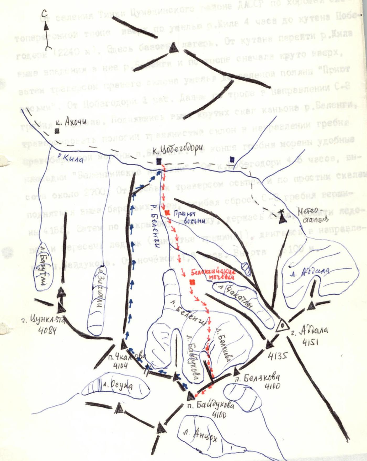
- Ascent region: №29 "Eastern Caucasus"
- Peak, its height, and ascent route: p. Kosarakumeer (4097 m) (p. Baidukova, 4100 m) via the Eastern ridge from l. Belengi.
- Proposed difficulty category: 2A category of difficulty and 1000 m, 12/2-80 g.
- Route characteristics: Height difference 1000 m. Average steepness 25°. Length of sections:
- I category of difficulty — 1550 m
- II category of difficulty — 400 m
- III category of difficulty — 550 m
- Pitons hammered:
- rock: 2
- ice: 6
- bolt: 0
- Number of walking hours: 9
- Number of overnight stays and their characteristics: without overnight stays
- Surname, name, patronymic of the leader and participants, their sports qualification.
- Krasnopolsky Yuri Vasilyevich — 1st sports category
- Pashuk Evgeny Grigorievich — 2nd sports category
- Leonov Petr Georgievich — 2nd sports category
- Yakhyaev Ruslan Krimsultanov — 2nd sports category
- Shutikov Vladimir Nikolaevich — 2nd sports category
- Team coach — Timoshin Mikhail Egorovich.
- Date of departure and return: May 7, 1979
Approach to the Route Description
to p. Baidukova via the Eastern ridge from l. Belengi, approximately 3A category of difficulty.
Route Sections Table
to the summit p. Baidukova (4100 m) via the Eastern ridge from l. Belengi, approximately 3A category of difficulty.
| Date | Designation | Average steepness, ° | Length, m | Relief characteristics | Difficulty | Condition | Weather conditions | Rock pitons | Ice pitons | Bolt pitons |
|---|---|---|---|---|---|---|---|---|---|---|
| May 7, 1979 | 1 | 30 | 550 | snowy slope | 1 | dense snow | good | single | – | – |
| –"— | 2 | 35 | 300 | traverse slope | I–II | dense snow, destroyed rocks | good | 1+ | – | – |
| –"— | 3 | 30 | 500 | snowy ridge | 1 | loose snow | good | single | ||
| –"— | 4 | 40–45 | 300 | snow-ice slope | 3 | thin snow on ice | good | – | 6 | |
| –"— | 5 | 5 | 150 | snowy ridge | 1 | dense snow on ice | good | single | – | |
| –"— | 6 | 0–5 | 400 | jagged ridge | II–III | destroyed rocks | good | ledges | ||
| –"— | 7 | 20 | 100 | gendarme | II–III | destroyed rocks | fog | 1+ | – | |
| –"— | 8 | 10 | 200 | ridge | 1 | destroyed rocks | fog | single | – |
Route Description
to p. Baidukova via the Eastern ridge from l. Belengi, approximately 3A category of difficulty.
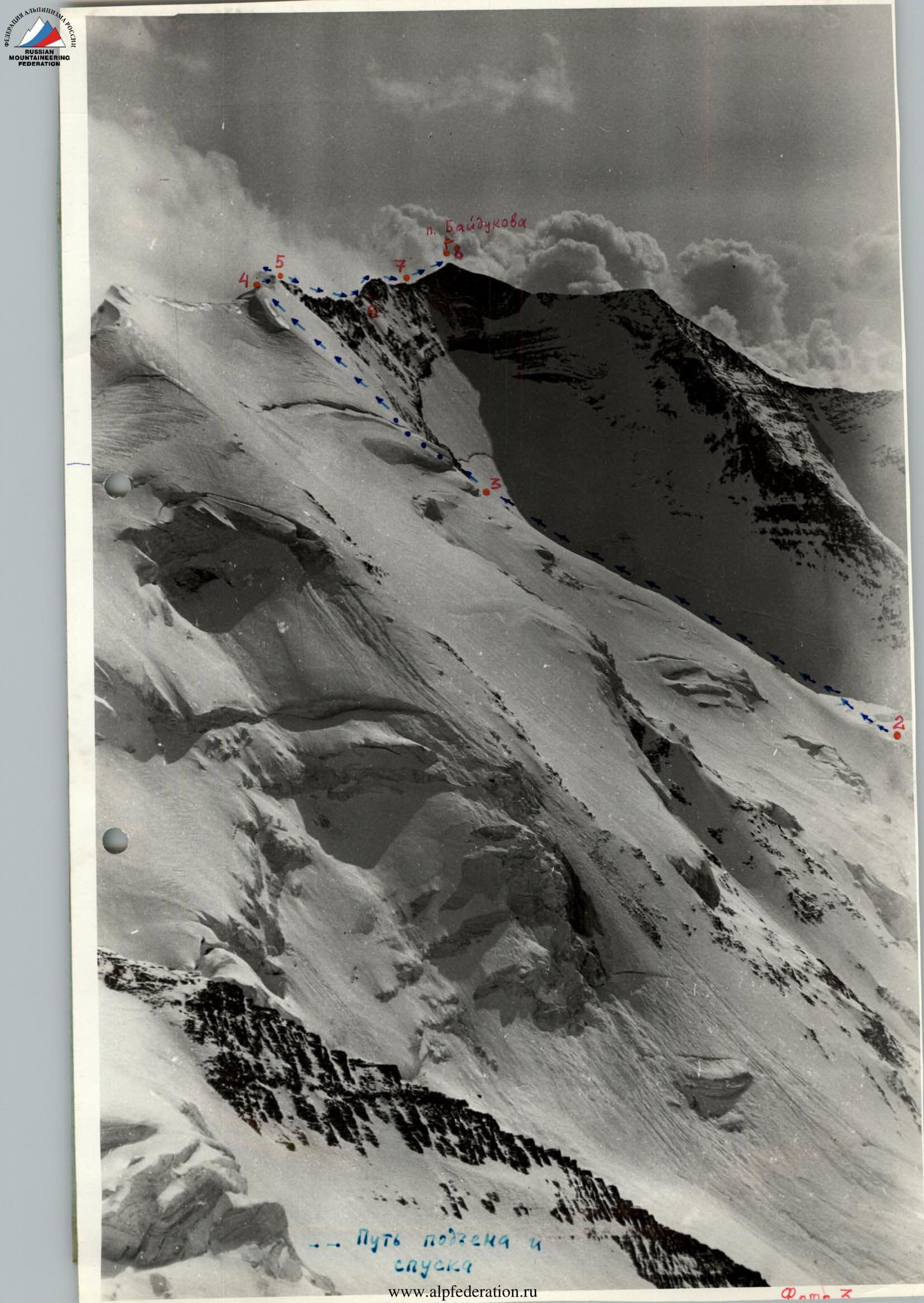
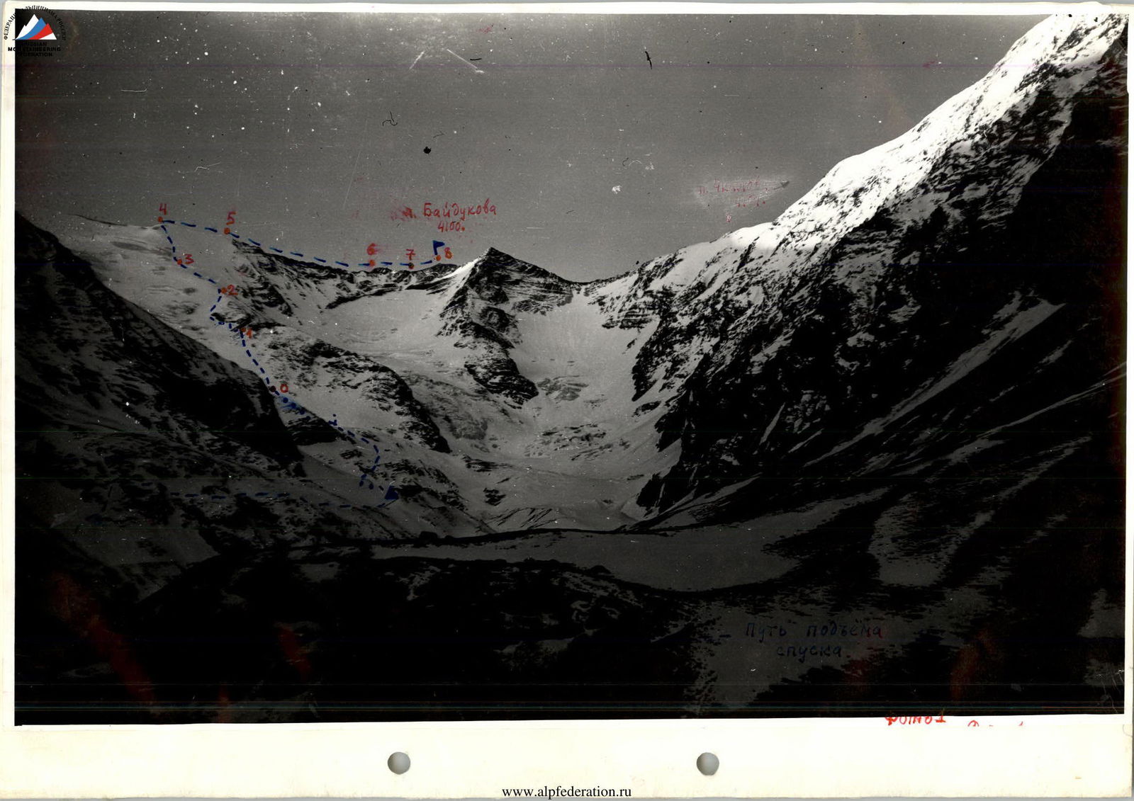
The route begins from "Belyakov Glacier" — the Southeast branch of l. Belengi along the snowy slope of the counterforce separating "l. Belyakov" from "Baidukov Glacier" — the southern branch of l. Belengi.
Having reached the rock dumps (1), traverse left along the rocks and snow, then along the steep snowy slope to reach a pad (2). Further along the simple snowy ridge to the ice wall (3), which is bypassed on the right.
From the start of the route 4 hours, height 3800 m. From here, along the steep ice (pitons insurance!), covered with thin snow, the exit to the ridge (cornice!) takes 2 hours. Further to the right. A simple snowy ridge (cornices!) (4–5) is replaced by a sharp rocky jagged ridge of medium category (insurance through ledges). The gendarme (6) is passed head-on (rock piton!) along the rocks, in places — ascent of medium category.
The summit is reached along a schistose ridge intersected by destroyed rocky belts. From l. Belengi — 9 hours. Descent along the ascent route takes 4 hours.
It is possible to traverse the ridge to the west through:
- Baidukova pass,
- p. Chkalova,
- descent along its North ridge (2A category of difficulty) to the Cobeago-dori meadow.