The area — Caucasus, Dagestan mountains. The peak — Eridag (NW) 3887 m via the cornices of the central part of the right bastion of the NW wall. It is proposed — 6B cat. dif., second ascent. The nature of the route — rock.
Characteristics of the route:
The height difference of the route — 1167 m. The height difference of the wall section — 1030 m. The length of the route — 3025 m. The length of the wall section (excluding the length of the traverse along the ledges of the summit tower) — 1175 m. The average steepness of the route — 64°. The average steepness of the wall — 75°. The average steepness of the bastion — 80°. The length of sections of 6 cat. dif. — 700 m, 5 cat. dif. — 200 m.
Left on the route:
Rock hooks — 0, anchor hooks — 3, piton hooks (8 mm) — 1, chock stones — 0.
Hooks used on the route:
- stationary pitons — 10
- removable pitons — 25 (8 mm).
Total protection used — 228, including skyhooks — 143.
Number of climbing hours — 51, days — 4. Number of nights — 3. Team leader — Klenov Alexander Valerievich, HMS.
Participants:
Devi Mikhail Marenglenovich, HMS. Borich Mikhail Alexandrovich, 1st sports category. Dashkevich Sergey Alexandrovich, 1st sports category.
Team coaches:
- Klenov Alexander Valerievich, HMS
- Yarunov Anatoly Anatolyevich, MS
Departure date:
For the ascent — July 16, 2005. To the summit — July 19, 2005. Return — July 19, 2005.
Organization: FAIS of the Sverdlovsk region.
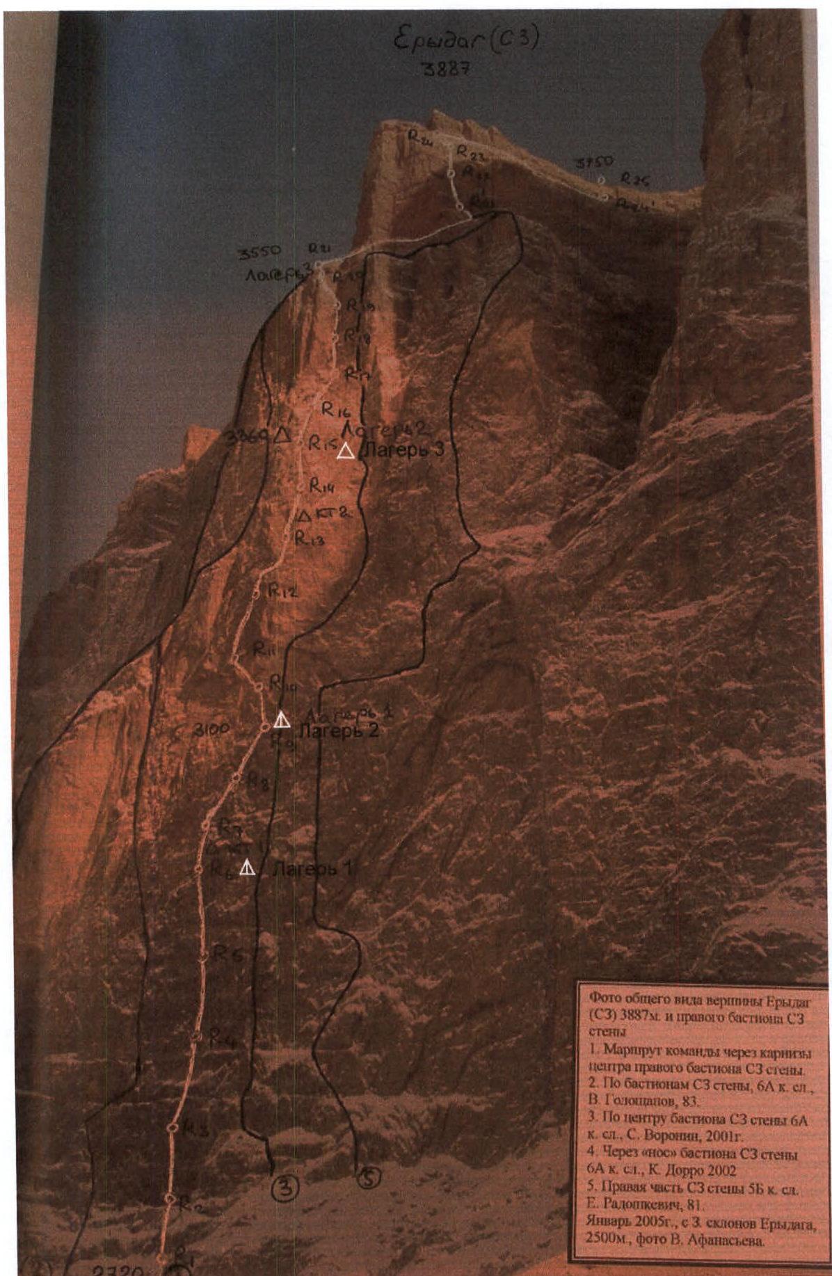
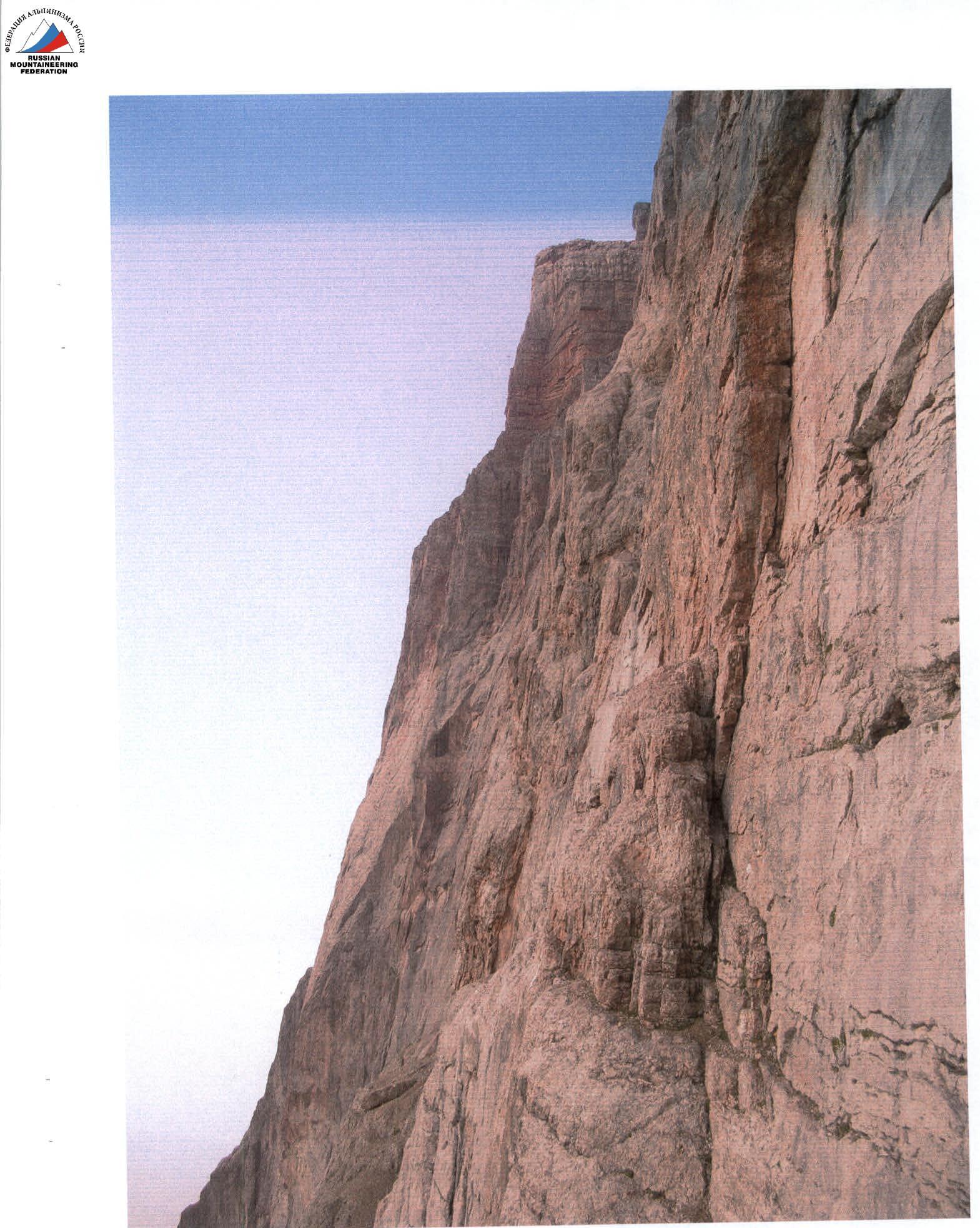
The photo is taken from the report on the first ascent by the team of the Alpinism Federation of Dagestan consisting of:
- Shanovasov Sh.E.
- Grigorov A.V.
- Dorro K.E.
- Tabakov S.V.
- Bibin O.Yu.
- Afanasiev V.Yu. (Erydag (NW) 14.02.2005)
3. Overview of the area and brief description of the ascent
The Eridag massif is located in a short north-eastern spur of the Main Caucasian Range, on the border of Russia and Azerbaijan, it forms almost a single plateau with Yarudag and Shahdag (plateau size 10×20 km). Walls up to 300–1200 m high drop down into Dagestan. The walls are mainly composed of metamorphosed limestones.
The trip to the ascent area from Makhachkala along the federal highway "Caucasus" to the south to the village Novo-Gopцах (180 km), then right, up the Samur river to the village Usukhchai (district center of Dokuzparinsky district) (225 km, 2500 m). The journey from Makhachkala takes 6–8 hours.
From the village Kurush:
- Descend along the trail to the confluence of the Seldy river into the Chekhychai river on the right (2250 m).
- To the right on the terrace (left bank) are the kung of the "Erydag" base of the Dagestan PSS EMERCOM of Russia (30 min) (it is possible to drive up by car along the new road leading to the Kurush border post).
- Then through two bridges exit to the terrace (right bank), along it slightly to the left in the direction of the Wall, walk about 800 m, cross the stream and exit to the farm.
- From the farm, slightly to the left, an unfinished road begins, along it along the slope (to the NE) walk about 2.5 km, and, turning to the right, move along the grassy slopes in the direction of the "Big Well".
- Traverse across the zone of gullies and clay couloirs.
- On the terrace to the right of the waterfall, 400 m from the wall — advanced base camp (ABC) (on the line of Babitsky's route), 4 hours from a/b Erydag (2700 m).
From ABC:
- Cross the gully in the area of large stones.
- With a slight gain in height, bypassing the rocky cape (on the line of Voronin’s route), enter the couloir.
- Here 2720 m, the beginning of the route from ABC — 30 min.
Shanovasov's route passes between Goloshchapov's and Voronin's routes in a straight line through smooth slabs and a belt of cornices to the monolithic internal corner. The "Direct" wall is the most difficult and straight line on the wall. Goloshchapov's and Voronin's routes deviate to the left and right, respectively.
The route is relatively safe in terms of rockfall. On the route, there is a problem with water; it had to be lifted in a haul bag in plastic bottles.
On the wall, there are sections of "singing" slabs that require particularly careful route selection and maneuvering along the wall.
During the ascent, the passage of the cornice belt was particularly problematic (the overhang of the cornices on the rope at 45 m was about 20 m).
In addition to the huge cornice in the center of the wall, there are 5 more cornice sections on the route with an overhang of 2–3 m. On these sections:
- the relief is unreliable
- the surface of the rock is flaking
- cracks are short and blind
- cracks are filled with calcium
Descent from the wall after passing the big cornice is impossible.
When passing the route, the team tried to minimize the use of pitons. At some stations and on cornices, previously left insurance points were used to move the last person pendulum-style.
When passing the cornices, various protection techniques were used:
- anchors,
- skyhooks,
- ice axes.
The first person worked in rock shoes and crampons. Haul bags were carried by pulling and transporting under the harness.
The weather was mostly sunny. This had both positive and negative sides:
- on the one hand — fairly good condition of the wall,
- on the other hand — the wall is lit by the sun for most of the day and turns into a "frying pan", which increases water consumption.
For organizing camps, one two-person platform was used. For overnight stays in the platform, sleeping bags were not used due to weight reduction in the conditions of the championship.
In total, the team had 6 ropes:
- 2 dynamic,
- 3 static,
- 1 cord for unloading the first person.
To increase safety, a double-rope belay technique was used.
Comparison of Shanavasov's 2005 route on p. Erydag with other routes of 6 cat. dif.
The described route is undoubtedly the most difficult route on the wall of p. Erydag. The only route more or less similar in difficulty to the main part of the route is Voronin's route, which goes to the right of Shanavasov's route. However, the route has a fundamental difference: a huge cornice, with a total overhang of more than 20 m and complex relief, consisting of several planes. A strong team needs a full working day to pass the cornice.
The complexity of Shanavasov's route is confirmed by the fact that teams of similar strength in the same weather conditions in the conditions of an on-site Russian championship spend twice as many climbing hours on this route as on such recognized difficult routes of 6A cat. dif., such as:
- Efimov's route;
- Babitsky's route "along the serps" — on the same wall.
If we compare Shanavasov's route with other routes of 6B cat. dif., then even on such technically complex routes in the CIS as routes on the northern wall of p. Aksu and NW wall of p. 4810, there is no such grandiose cornice, and the difficulty of climbing most sections is noticeably less. The length of sections of 6 cat. dif. on Shanavasov's route:
- exceeds the length of such sections on routes of 6B cat. dif. on p. 4810;
- is not inferior to the N wall of p. Aksu.
Unlike p. Kukurtly, where the 6B route was classified not so much for technical difficulty as for objective mortal danger, Shanavasov's route is objectively safe. The presence of such a route on the territory of the Russian Federation will allow:
- to raise the level of the strongest young Russian athletes;
- to bring their training to the highest international standards;
- not to expose their lives to unjustified danger.
All of the above allows us to classify Shanavasov's route as a route of 6B cat. dif., provided that the route is passed through both control points available on the route.
Mikhail Devi, Honored Master of Sports of the Russian Federation, with experience of passing 30 routes of 6 cat. dif.
5. Description of the route by sections
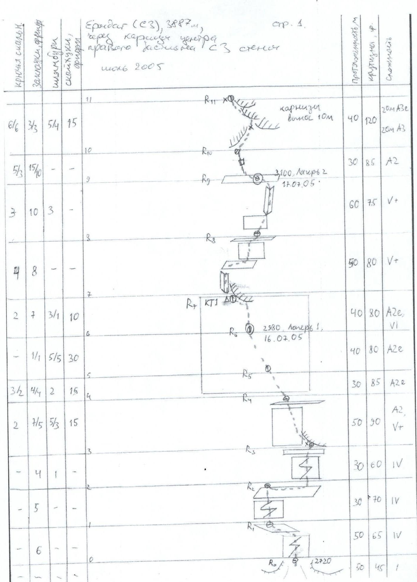
Section R0–R1. Length 50 m, 4 cat. dif. The beginning of the route is in the upper part of the talus, located to the left of Voronin's route. Up to the left along the destroyed wall to a horizontal ledge (about 0.5 m wide), along it traverse to the left.
Section R1–R2. Length 30 m, 4 cat. dif. Up the wall to the exit to a large talus ledge. Danger of dropping stones with a rope.
Section R2–R3. Traverse along the talus ledge to the right 20 m, then vertically up the wall 10 m, 4 cat. dif. From the ledge, a piton with a loop under the cornice on R3 is visible. Station on a convenient ledge under the cornice. In summer, R3 can be approached from the right (from the side of Voronin’s, Rodoschkevich’s route) along a series of ledges.
Section R3–R4. Length 50 m, A2e, 5+. First up the crack under the cornice (medium-sized friends), then along the wall mainly on skyhooks and removable pitons to an inclined talus ledge. Station on 2 × removable pitons.
Section R4–R7. Length 110 m. A2e. Along the wall on "hole" skyhooks. General direction left-up under the cornice — "brow". The relief is extremely poor, climbing is impossible due to the lack of possibility to organize reliable insurance. Sometimes friends go, which are inserted into cavities. The reliability of these points is very conditional. A fall can be dangerous. For insurance, we had to use pitons. In R6, they stopped for the night (platform). Stations are hanging, uncomfortable. In R7, CT1 is located.
Section R7–R8. Length 50 m, 5+. The cornice is bypassed on the left, then by climbing along the internal corner to the exit to a ledge (30 m), along the ledge to the right (about 10 m) and up along the "ram's foreheads" (10 m). Standing station on friends and anchor hooks.
Section R8–R9. Length 60 m, 5+. Up the wall to the base of the internal corner. Up along it to a large ledge. Insurance is reliable, on medium and large friends. Camp 2.
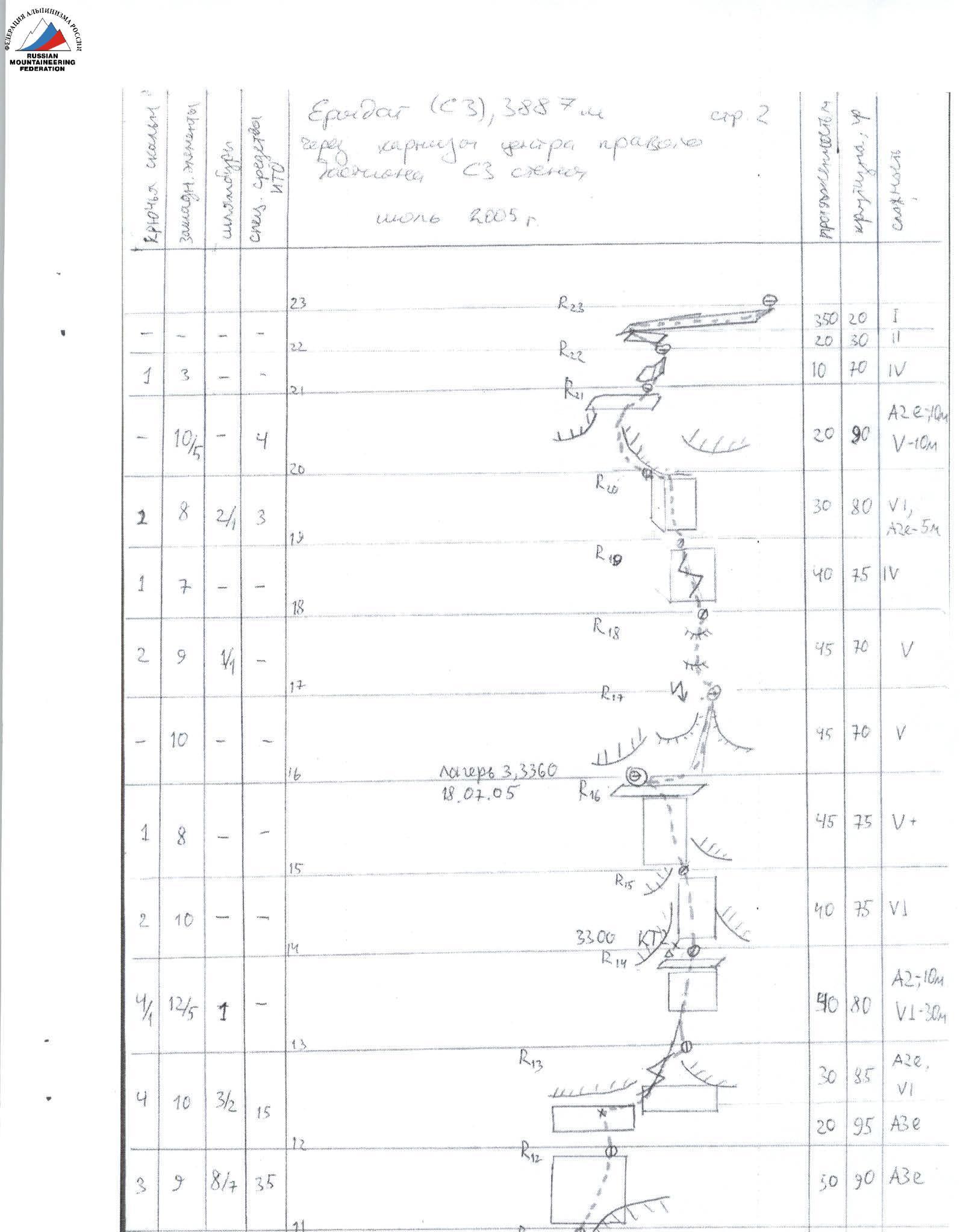
Section R9–R11. Length 70 m. First to the left up the crack to the beginning of the big cornice (30 m, A2). The cornice is passed along a series of ledges with a general direction to the left on skyhooks and pitons protection A3e. The station is extremely uncomfortable, hanging, on pitons.
Section R11–R13. Length 100 m. Up the "hole" path to a piton with a loop under the cornice (70 m, A3e). Insurance on pitons, friends, stoppers and anchor hooks (cavities). From the piton to the right-up — difficult climbing bypassing the cornice to the beginning of the crack (30 m, 6 cat. dif.).
Section R13–R16. Length 125 m. Combination of climbing (5+, 6 cat. dif.) and protection A2 with a general direction to the left-up to a large ledge under the cornice. Stations are hanging or semi-hanging. For insurance, friends go well. Camp 3. Control tour 2 is located in R14.
Section R16–R19. Length 130 m. Up the couloir, "ram's foreheads" and a series of cracks to the base of the internal corner. Climbing 5 cat. dif. Reliable insurance on friends and stoppers of medium size.
Section R19–R20. Length 30 m. Up the internal corner to a heavily destroyed chimney with a plug (overhang 1.5 m), which is passed on the right side. Difficult climbing, unreliable insurance points (6 cat. dif.). At the top, the internal corner rests on cornices. Under them, a departure to the left along the "hole" path (A2e). The station is hanging.
Section R20–R21. Length 20 m. Along the "holes" on skyhooks to the left-up to a large ledge (A2e, 5).
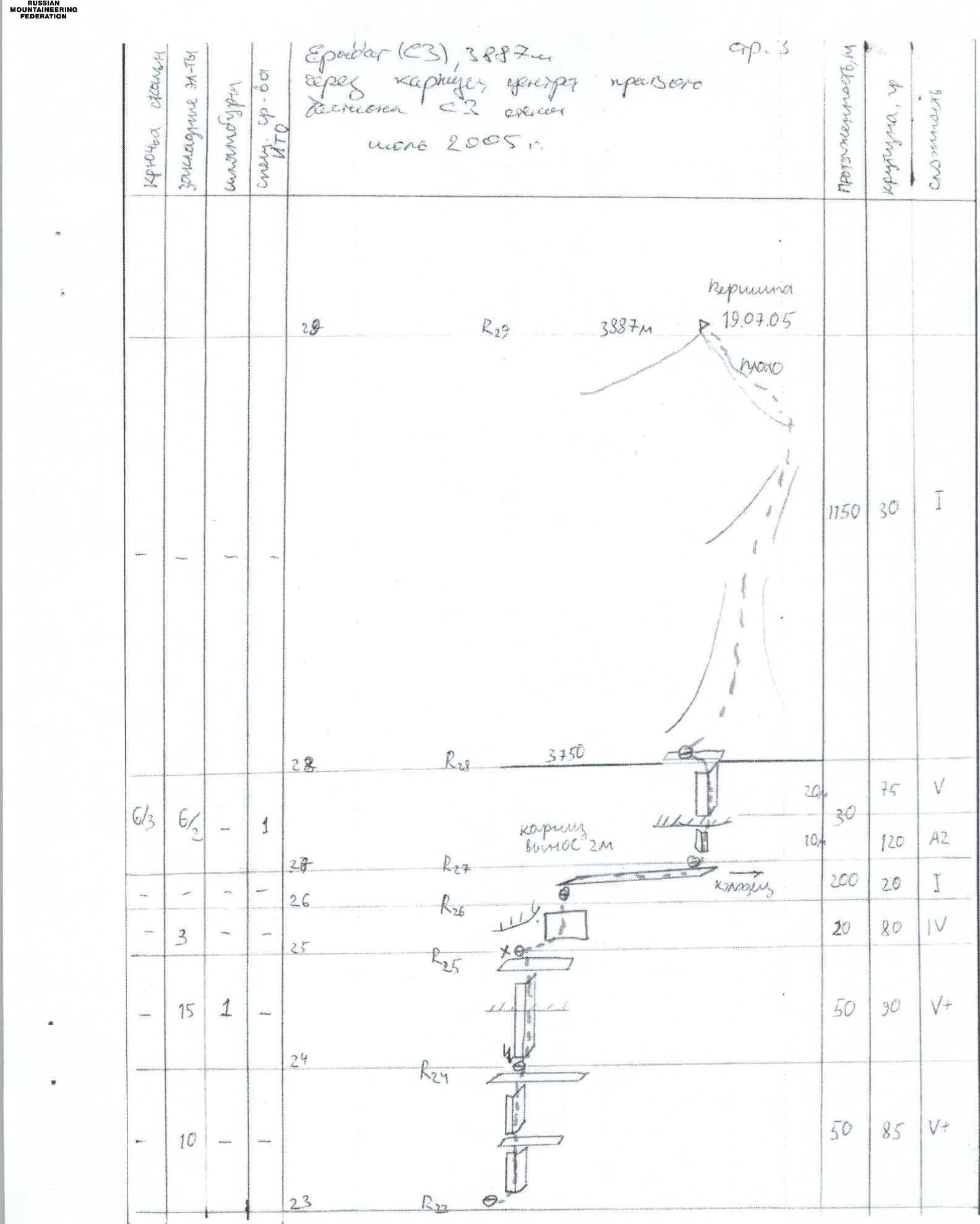
Section R21–R23. Length about 400 m. Exit along the internal corner in the right part of the ledge (10 m, 4 cat. dif.) and then along a huge ledge under the summit tower traverse to the right to the internal corner (1 cat. dif.).
Section R23–R28. Coincides with the routes of Dorro, Rodoschkevich, Goloshchapov, Voronin.
Descent direction: along route 1B through v. Seldy.
- UIAA scheme.
- Photograph of the route profile.
- Photographs from the route.

10.1. Section R10–R11. Taken from R9. Passage of the big cornice.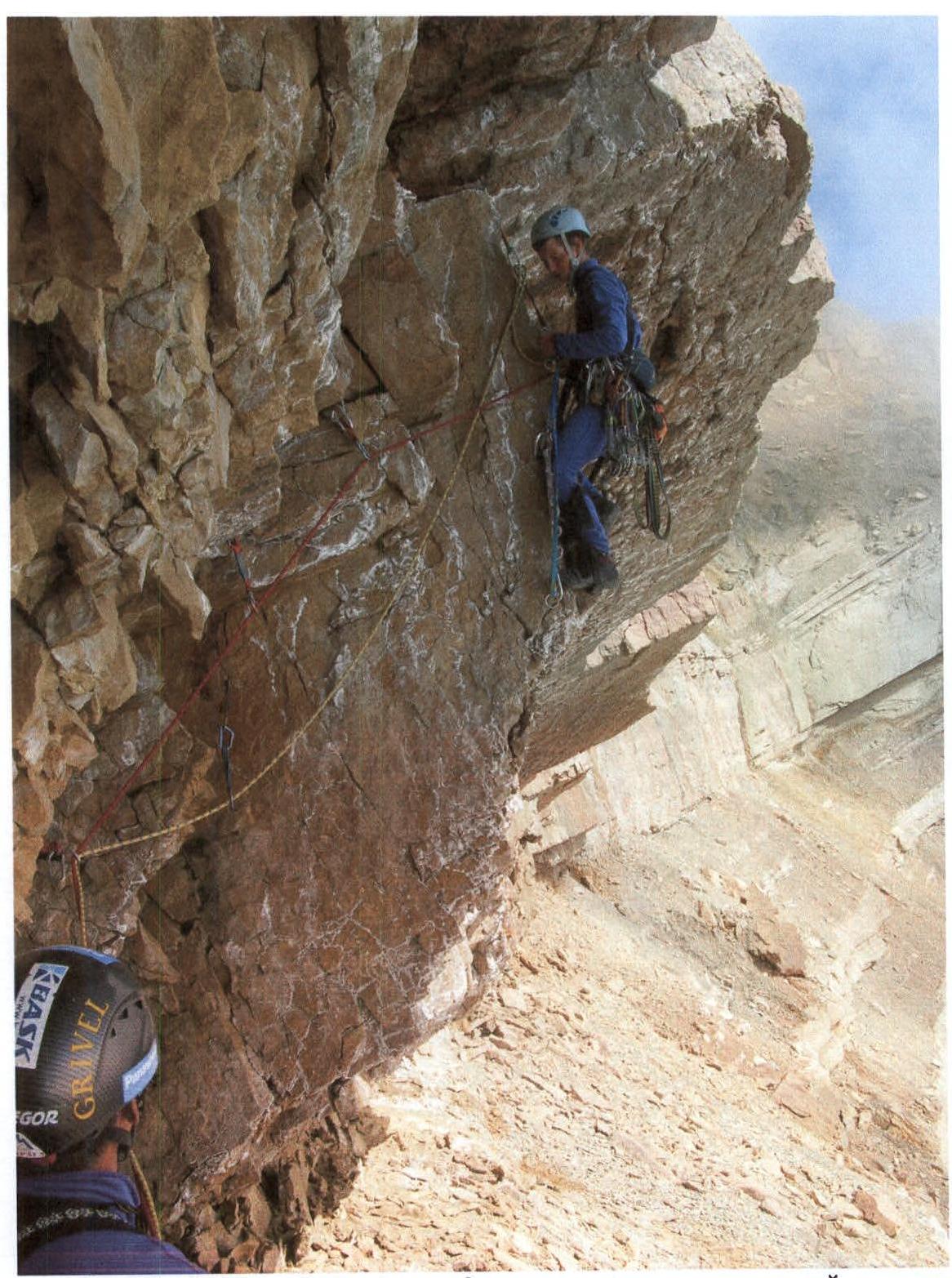
10.2. Section R27–R28. Passage of a 2 m cornice at the beginning of the last rope to the exit to the plateau. (In the conditions of an on-site competition at the Championship, the team did not have the opportunity to conduct normal photography on the route)