1. Climbing Passport
-
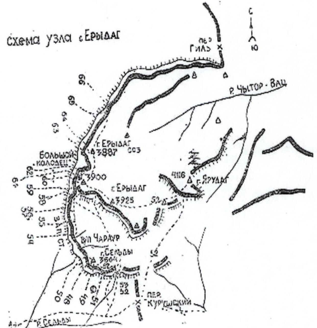
Region: Caucasus, Dagestan Mountains, Chekhychai gorge.
-
Erydag (NNW), 3887 m, via the center of the right bastion of the NW wall, Voronin Route.
-
Second ascent. Estimated category 6B.
-
Rock climbing route.
-
Route height difference: 1100 m, route length: 2700 m, wall height difference: 950 m, wall section length: 1200 m (excluding traverse along the ledge from R23 to R24), average wall steepness: 75°, average bastion steepness: 80° (from R0 to R22), length of sections with category V difficulty: 405 m, category VI: 540 m, length of sections with artificial aids (ITO): 545 m, with complexity A1: 15 m, A2: 260 m, A3: 270 m, including 330 m on skyhooks.
-
Pitons left on the route:
- rock pitons: 14
- sling pitons: 2
- removable bolt pitons: 0
- stationary pitons: 2
- "spit" втулок (12 mm): 3 Holes from removable bolt pitons (8 mm): 20
Insurance points used:
- total/including for ITO: 464/281
- rock pitons: 127/84
- chocks: 270/147
- bolt pitons: 57/46
- including stationary: 20/4 Skyhooks used: 83 times Total artificial support points (ITO) used: 315
-
Team's climbing hours: 4 h 5 min days: 5 Including preliminary processing: hours: 11 days: 1 Nights spent:
- 1st night in ABC under the wall in tents (2750 m);
- 2nd night on an uncomfortable hanging platform (3100 m);
- 3rd-4th nights on an uncomfortable hanging platform (3330 m).
-
Team leader: YArunov Anatoliy Anatolyevich — MS
-
Team members: Blinov Gennadiy Vladimirovich — MS, Kofanov Sergey Anatolyevich — MS, Novoseltsev Evgeniy Leonidovich — CMS
-
Coach: Ostanin Viktor Vasilyevich
-
Preliminary processing: July 3, 2002 Departure on the route: July 4, 2002 Summit reached: July 7, 2002 Return to Kurush base camp: July 7, 2002
-
Organization: FAS Sverdlovsk Oblast, Yekaterinburg, 2002
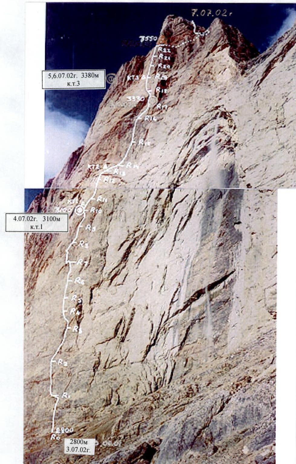
1.2. Photo of the wall from ABC with the team's route (photo from the report by Mountaineers from Dagestan Emergency Ministry)
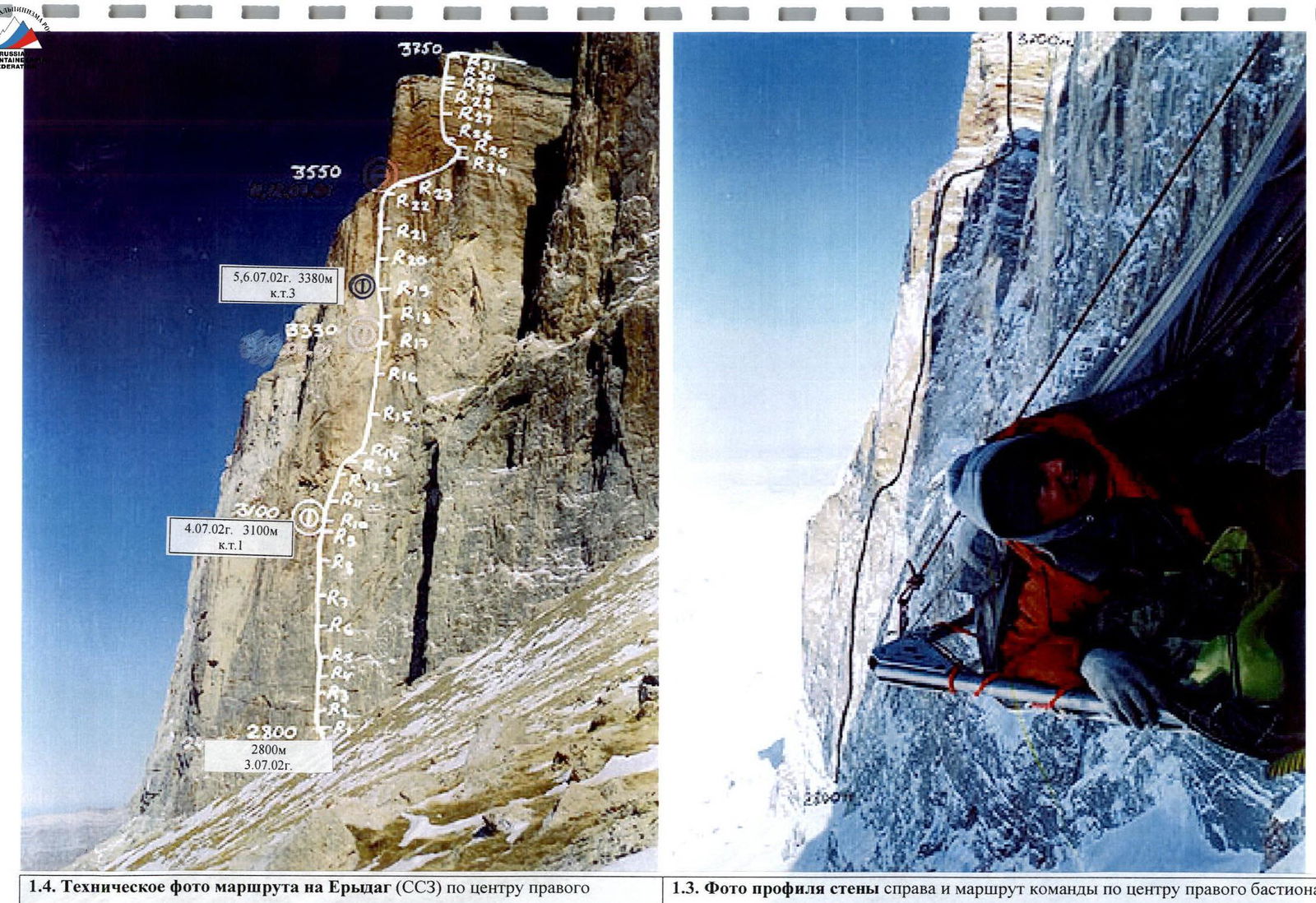
1.4. Technical photo of the route on Erydag (NNW) via the center of the right bastion of the NW wall. February 2000, taken from the slope of Erydag at an altitude of 2850 m. (photo from the report by Mountaineers from Dagestan Emergency Ministry)
1.3. Photo of the wall profile to the right and the team's route via the center of the right bastion of the NW wall. February 2000, taken from the left bastion of the 3rd wall of Erydag, at an altitude of 3250 m. (photo from the report by Mountaineers from Dagestan Emergency Ministry)
Scheme of the "Erydag" knot
4. Route Description
The route is attractive due to its length and steepness. Until 2001, the overhanging middle of the bastion remained unclimbed. The teams led by Rodoshkevich and Goloshchapov deviated from the vertical and moved to the sides (right and left). The passage is significantly complicated by the lack of water on the wall in both summer and winter. The center of the bastion was first climbed by a team of mountaineers from the Dagestan Emergency Ministry in 2001.
The approach to the start of the route is to the left along a ledge that begins from the right "sickle" of the waterfall's cornices. Special care should be taken when passing under the waterfall and the well — the risk of rockfall, especially after rain. The ledge is about 200 m long.
When the ledge starts to narrow and descend — it's the beginning of the route. On the same vertical as a large protrusion — an "ogurtsa" (big cucumber). From the ledge, climb the wall to an osypnaya ledge, where R1 is located. Drop down slightly to the left and climb up through a shallow internal corner, which ends in an overhang. From the corner, move left across the wall to a small ledge (R2), then further up the slab to the right and up to the internal corner of a small "ogurtsa". In its middle is R3. On all slab sections here and further, it's necessary to use skyhooks, sometimes even in internal corners, as placing a rock piton for ITO or even a chock takes longer than using a skyhook.
Climb the overhanging corner to the "ogurtsa". Then continue up the slab to R4, from there up the slabs and corner to R5 (a small ledge). Then, a similar steep relief of slabs and shallow internal corners leads to R6. From there, the direction is left and up through a corner and a crack to R7, then descend slightly. Further, along the corner and slab, first strongly to the left, and then to the right to a system of corners, with R8 in the middle. Then, across a slab into an internal corner, the middle of which overhangs, at the end of the corner is R9, and up the slab and corner to a small ledge — here is R10, on a rock piton, control cairn 1 (a can on a reepschnur).
The location of camp 1 (3100 m) is to the left on a slab where a platform was hung. Above the camp, the cornices of the middle of the bastion overhang, to the left are the sheer edges of the bastion's corner. Camp 1 is the leftmost point of the route from the vertical. The cornice narrows and descends to the right in a sickle shape. The general direction of movement is to the right and up.
From R10, climb up the internal corner and slab to R11 — a station on a two-meter tooth of a rock outcrop. Then, to the right up a crack that thins out as it goes up, and across complex slabs — to the narrowest part of the cornice. Under the cornice on a small ledge is R12. Further, across a slab to the cornice, with an overall overhang of about two meters, formed by three steps, there's a wedged block. Be cautious! Behind the cornice, to the right and up across a smooth slab to R13 — a narrow ledge. At the station: a stationary bolt piton, a can on a reepschnur — category 2 (3180 m). Further, up a monolithic wall to a rock outcrop (to the right and up), then to the right, almost horizontally, traverse across a system of rock outcrops and cracks to R14 — a narrow ledge that thins out as it descends.
Further, to the right and up across monolithic "ram's heads" to an indistinct groove and internal corner, up it to a rock outcrop, from the outcrop across a slab to a second, smaller outcrop, on which is R15. From the station, up and slightly to the left, and when relief for rock pitons appears — again slightly to the right. At the bend to a more gentle slab — R16.
A more calm relief: from the station to the right and up through a crack to an internal corner (the right edge overhangs), then again across a slab to the left and to a corner and rock outcrop. Here is R17. To join the slabs into an overhanging corner, move up the internal corner to the left. At the junction of the slabs forming a large corner — camp 2 (3330 m). The left wall overhangs strongly, the right wall is sheer. The platform is protected by an overhang.
Up the corner and further beyond the bend to the left through an internal corner — a couloir to a slab (R18). To the right and up, a system of internal corners continues, but they thin out. Move to the left and up behind a convex wall and then steeper up, exit onto a vein of reddish sandstone. Then: through cracks, rock pitons go well, and sometimes chocks. Approach under a small corniced section, here is R19 and category 3 on a rock piton (3405 m).
Above, the sandstone vein forms a groove-chimney (depth 1–1.5 m), rock pitons don't fit. In a small niche is R20. From the station, to the left and up through an indistinct groove. It gradually veers to the right and deepens, leading into a deep chimney-cave. The depth inside the wall is up to 12 m. A lot of bird droppings. The ceiling overhangs. In the depths — station R21. From it:
- exit closer to the edge;
- move up in a stem, sometimes on ITO. The depth of the chimney varies from 4 m to 1 m, and it leads to a bend — here is R22. Then — a flattening out of large-block rocks and a ledge. Station R23 is at the wall. On the ledge — scree, be cautious with the rope, rocks!
To the right on a headland — a flat area and a possible spot for a lying overnight stay (3550 m). Orientation cairn:
- Along the ledge to the right to the Big Well.
- Around the corner to the left.
- Immediately behind the corner to the left, then along the ledge for about 300 m to the waterfall.
- Up through a short rock step to scree.
- Across scree to the first rock belt.
Rocks with reverse slopes and overhangs. Start up an internal corner with a crack to the right, 10 m from the outer corner (edge of the wall belt) in the middle section slightly to the right through an overhang and again up the corner to a ledge — here is R27. At the station in a niche lies a wooden seat left by the team (with an autograph). Be cautious on the ledge — rocks! Further:
- Up a crack transitioning into an overhanging internal corner;
- The corner is locked, move to the right beyond the outer corner;
- Then up cracks to the right and up to a ledge — here is R28;
- Across a small step to a large ledge.
The first belt is passed.
The exit through the second belt is possible 200–300 m to the right along the ledge, where the rock step is lower, but it's noticeably wetter and significantly further to the right from the logical thread of the route. There are 2–3 acceptable exits. But the team passed through a crack 16–18 m to the right of the edge, the upper section overhangs. R31 can be reinforced with a sling around a destroyed remnant. Further:
- To the right, traverse along the ledge and scree to a couloir — this is the passage through the third belt.
- Then to the right along the stream bed and further onto the plateau.
- The summit is to the left along the path, if heading in the direction of Yarudag.
Descent direction: towards Erydag, to the left of its dome along the stream. Descent via 1B (without entering g. Sel'dy).
Note: the bastion's exposure is purely western, the wall becomes NW, behind the left edge of the bastion.
Tactical Actions of the Team
The team arrived in the climbing area on June 24, 2002, for a training camp and participation in the XX Russian Championship, rock climbing category.
June 24. Cargo was transported and a base camp was set up below the village of Kurush in the area of the kungs.
June 25–29. For a training ascent, the Dorro route, category 5B, was chosen. Over 2 days, 5 ropes were fixed — 9 climbing hours (55 m rope), practically completing the processing of the lower bastion. Due to unstable weather, it was decided to stop the ascent for rest before the Championship.
July 1. Championship opening. After the draw, we received the last, 10th place. We decided to queue until higher-rated routes became available.
July 2. We transported products and equipment under the wall to the area of Yefimovskie night stays. At Yefimovskie, we learned about an accident on the Voronin route in a team from St. Petersburg. We participated in rescue work. After completing the rescue work, we decided to ascend the Voronin route within the framework of the Championship.
July 3. Blinov — Novoseltsev began processing the route. They fixed 400 m of ropes from 9:00 to 20:00 and descended under the wall to Yefimovskie night stays by 21:00. For the day, they processed 20 m above the 1st control cairn. The last station was under a cornice, 10 m from it. The weather was clear.
July 4. The team started on the route at 10:00. Blinov — Novoseltsev went first and continued processing the route. Kofanov — Yarunov lifted the main cargo (including 30 l of water) and a platform. Out of 8 fixed ropes, 5 were left, the rest were dropped. For the day, they passed another three ropes (cornice of the 2nd control cairn + traverse). The platform was set up in the area of the 1st control cairn. A ledge 4 m long and 0.4 m wide made."
July 5. Blinov — Novoseltsev passed 3 ropes (150 m), working from 9:00 to 20:00. For the day, they processed a section up to the 3rd control cairn, located under a cornice, and further up a chimney by 20 m. The platform was set up under the cornice at the level of the 3rd control cairn. The weather was cloudy, without precipitation.
July 6. At night, a front arrived, and the weather deteriorated. The duo Novoseltsev — Kofanov fixed 2 ropes in the chimney from 10:00 to 13:00. To the ledge where the routes of Voronin, Goloshchapov, and Rodoshkevich converge, 10 m remained; they descended to the platform. Water was flowing down the chimney. Further advancement was deemed impractical. The ascent to the summit was postponed to the next day. It rained with snow from morning and throughout the day. Fog.
July 7. In the morning, the rain stopped. The weather was cloudy. We started work at 6:00. Blinov and Novoseltsev reached the Goloshchapov ledge at 7:00 and fixed 3.5 ropes to the summit (along the Rodoshkevich route). The group reached the summit at 16:00. The descent to the base camp under Kurush took 5.5 hours from 16:30 to 22:00.
The team used a large amount of equipment on the route. So, during the ascent, 8 ropes of 55 m each were used for processing on the first day, then 5 ropes, various rock pitons and chocks (hexes, stoppers, friends, camalots), bolt pitons were used, removable (8 mm) and several stationary ones, on particularly critical stations — "spits" (12 mm). However, a feature of the route is the extensive use of skyhooks on smooth and monolithic slabs and sections without vertical relief. This significantly sped up progress on the route, as placing a skyhook and standing on a kraig hook is much faster than hammering in a piton for ITO, and even more so, a bolt piton. The first climber worked on kraig hooks. On some sections (cornice, traverses), the last climber had to use self-release. The cargo was transported by hanging it under the harness.
The lack of water on the bastion complicated the ascent due to the need to lift additional weight. Water consumption was based on 2 l of water per person per day. A total of 30 l of water was carried up the wall. The speed of passage was high due to the excellent rock climbing preparation of Novoseltsev and Blinov. Kofanov worked last on the traverse. The route can be conditionally divided into two parts by complexity: up to the first camp and above it. The first, lower part was climbed in stable, dry, clear weather, which allowed for the full realization of Blinov and Novoseltsev's excellent rock climbing skills. The second part is characterized by high steepness of the relief, overhangs, and an alternation of monolithic and heavily destroyed rocks. Bad weather and wet rocks added complexity. With strong wind, the route below the watercourse is additionally watered and covered in dirt. On the upper bastion's ledges, a lot of dirt and rocks are observed, requiring special caution when organizing ropes.
Organization of the ascent — Yarunov A.A. Compilation of the report — Yarunov A.A., Kofanov. Information support: www.dgu.ru↗ (page "Mountaineering in Dagestan" — Elena Ilyina).
Note
- The climbed route is the most complex among those laid on the NW wall of Erydag and can be recommended by the Classification Commission of the FARC for consideration for inclusion in the list of "6B" category routes.
- Under the conditions of the ongoing Russian Championship, the team did not have the opportunity to capture a full-fledged photo material. The report uses materials from the report on the first ascent by mountaineers from the Dagestan Emergency Ministry (with their consent).
- Notes from the control cairns were passed to the chief judge of the competitions, A.P. Kurshin.
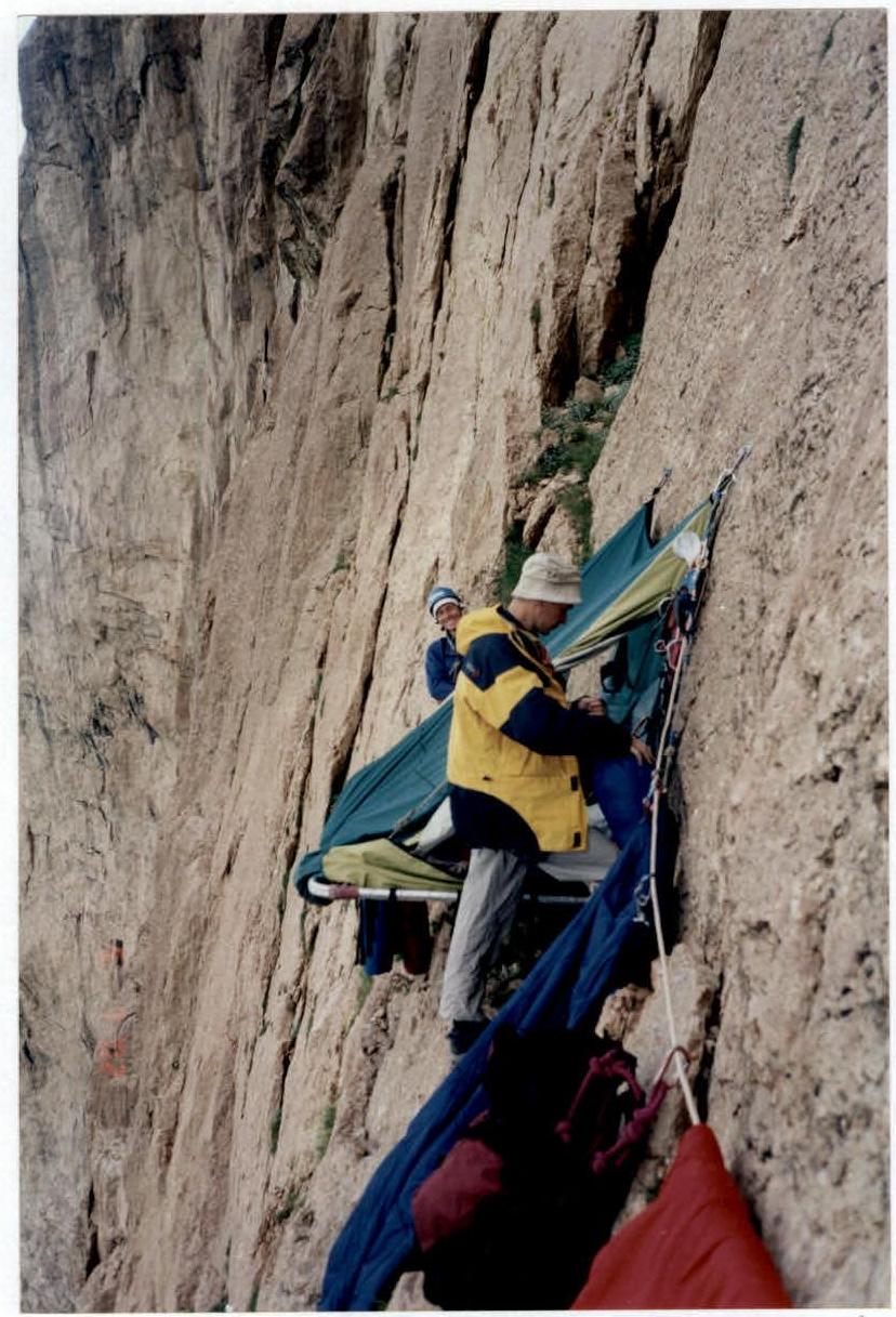
Photo 1. Platform of camp 1 (3100 m). Taken from the ropes, Blinov G. and Novoseltsev E. are preparing to start processing. Underfoot is a convenient ledge. August 5, 2002.
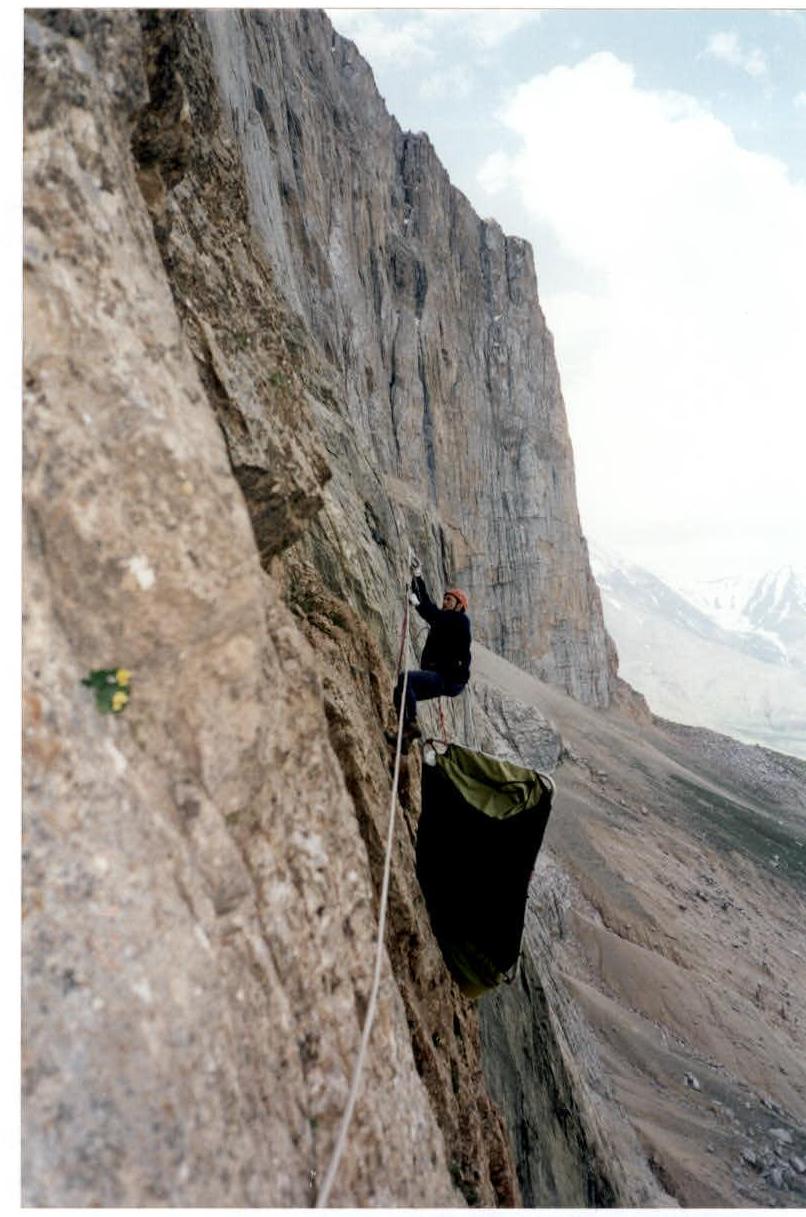
Photo 2. Lifting the platform by Yarunov A. Taken from the ropes from camp 1. August 5, 2002.