Ascent Passport
- Category of wall ascents.
- 2.10. Caucasus, Dagestan mountains, Chekhychai gorge.
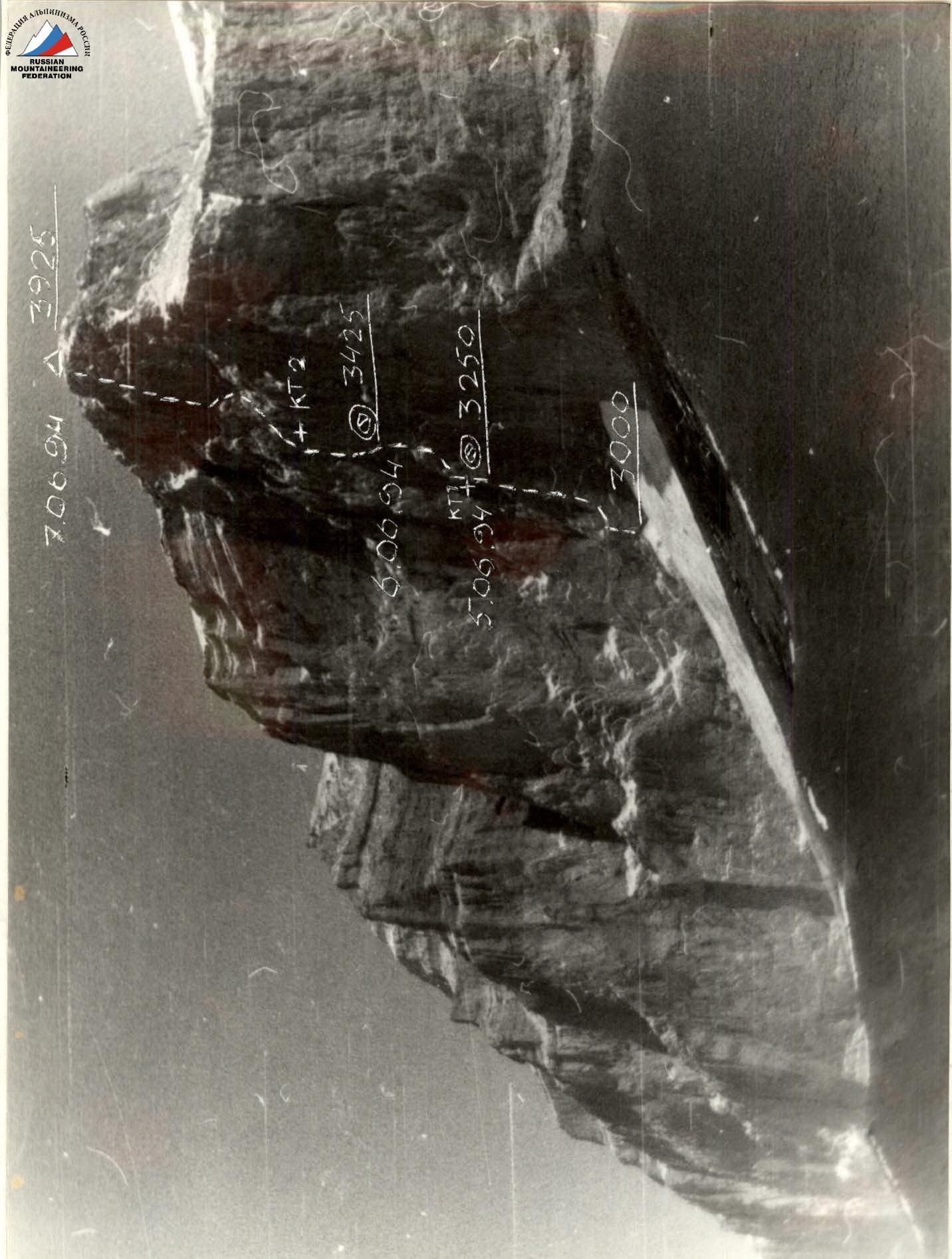
- Erydag, 3925 m, point 31–32, Mikhailov's route, 1982, via the right part of the NW wall, rock.
- 6A category of difficulty, " беспрохождение".
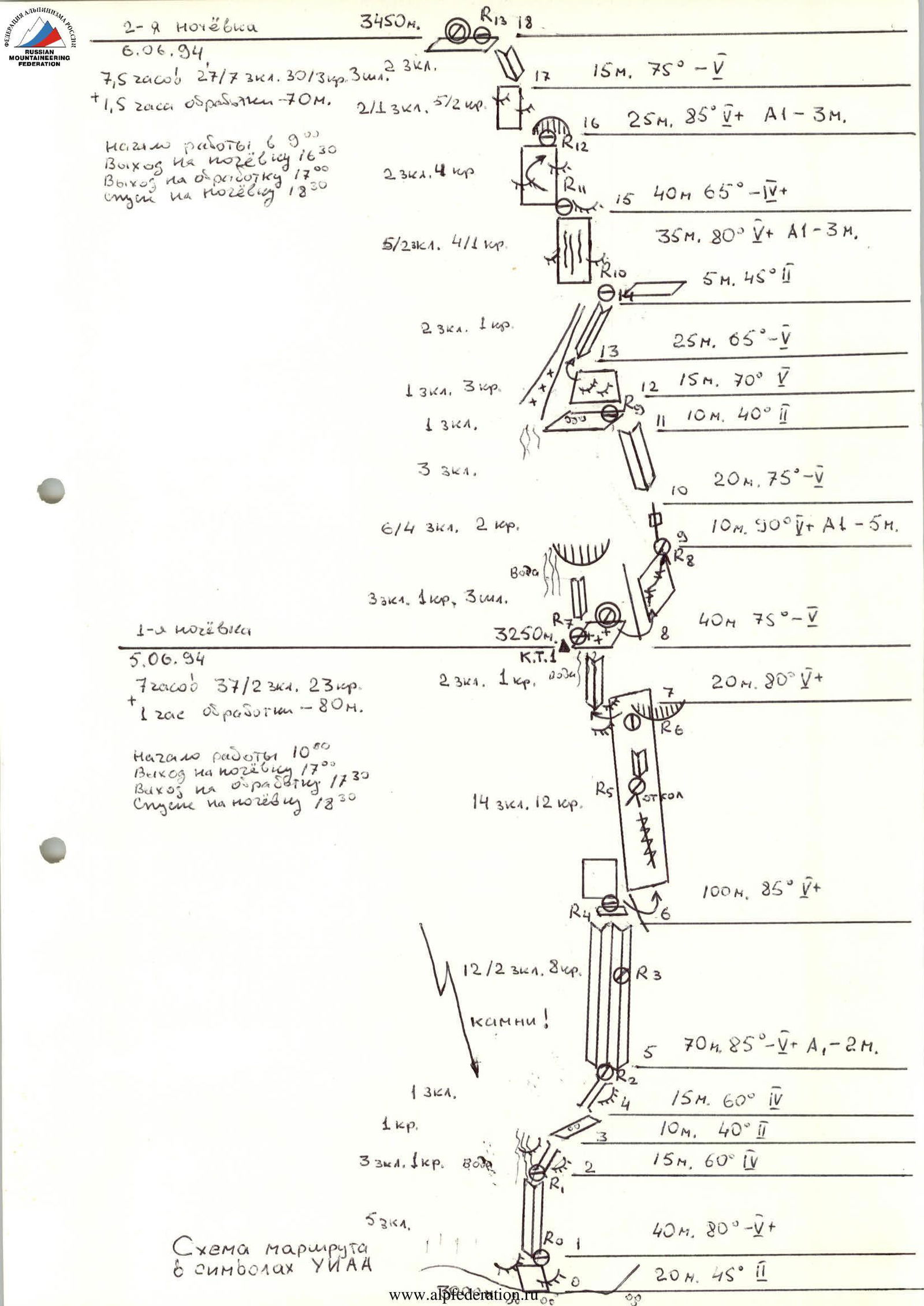
- Route characteristics: height difference 880 m, wall length 960 m, average steepness 70°, total length of the wall section 1125 m, length of sections: 2 category of difficulty — 45 m, 3 category of difficulty — 120 m, 4 category of difficulty — 130 m, 5 category of difficulty — 770 m, 6 category of difficulty — 60 m, including 20 m with A3 climbing; artificial support points: A1 — 25 m, A2 — 15 m, total length with artificial support points: 60 m; on sections: 5 category of difficulty — 25 m, 6 category of difficulty — 35 m.
- Used: 122/29 chocks, 118/9 rock pitons, 10/3 bolt pitons. Of these, 4 previously hammered rock pitons were used and not removed, 2 own pitons were left on the route, 10 previously hammered bolt pitons were used.
- Team's working hours — 28, days — 3. Including 2.5 hours of evening preparation and 27.5 hours on the wall.
- Overnights: 1st (3250 m) under a cornice on an extended hammock shelf, semi-reclining, five people in a tent; 2nd (3450 m) under a cornice. Three people semi-reclining in a niche, with feet on a hammock, two people on a shelf sitting.
- Leader: Smotrov Sergei Ivanovich, Candidate Master of Sports.
Participants:
- Aliyev Shankhal Ramazanovich, 1st sports category
- Dorro Konstantin Eduardovich, Candidate Master of Sports
- Leonov Petr Georgievich, Candidate Master of Sports
- Pashuk Evgeny Grigorievich, Candidate Master of Sports
- Coach: Leonov Petr Georgievich, Candidate Master of Sports.
- Departure to the route — June 5, 1994. Summit — June 7, 1994. Return to "Erydag" base camp — June 8, 1994.
- Organization: State Committee for Sports, Youth Affairs and Tourism of the Republic of Dagestan.
Makhachkala
— 1994 —
Tactical Actions of the Team
There were no deviations from the tactical plan in terms of time and overnight locations. The team worked well, completing the plan even slightly ahead of schedule.
- On the first day, June 5, 1994, they reached the overnight location an hour ahead of schedule (by 17:00 instead of 18:00), allowing more time for setting up the site. The pair Dorro K. and Smotrov S. processed two more ropes and descended to the overnight location by 19:30.
- By the second overnight on June 6, 1994, they arrived 30 minutes ahead of schedule (by 16:30 instead of 17:00), allowing the pair Smotrov — Dorro to rest and approach and process a problematic internal corner with a time buffer, as well as collect ice for water. Smotrov descended to the overnight location at 19:30.
- On the third day, June 7, 1994, the team worked on 16 ropes (2 were pre-processed). They reached the 2nd control point exactly at 11:00.
- Dorro took 45 minutes to climb the third, steepest rope of the corner R16–R17. Overall, the group showed excellent endurance and coordination on this day.
- They reached the plateau at 19:30 (planned 20:00) and the summit at 20:00, ahead of schedule by 30 minutes. The team descended to the scree fields on the ridge and set up an overnight near a stream.
- On the next day, June 8, 1994, they were at "Erydag" base camp by 12:00.
The rope team system was refined from previous ascents.
- On the first day, on sections R0–R8 and R8–R12, Dorro K. led.
- On the second day, June 6, 1994, sections R12–R18 and R18–R21 were led by Smotrov S.V.
- On the third day, June 7, 1994, the leading pair was Dorro — Smotrov on R21–R41. The change of leaders went exactly as planned.
The safety of the first climber was ensured by a double rope (УААА), and an absorber on the harness.
The average climbing speed was 41 m per hour, but the actual rope progression speed (excluding rest and evening preparations) was about 45 minutes. This is an excellent result for such a route. Rest was taken at planned overnight locations, and on June 7, 1994, on a ledge at point R32, where there was water and protection from rocks in a niche. Hot drinks (stove!) and high-calorie nutrition were used.
The overnights were safe, and their locations exactly matched the tactical plan.
There were no falls or injuries. The change of leaders and good climbing ability allowed for successful climbing, including in the internal corner. The team completed the ascent with a reserve of physical and mental strength. The equipment was used to its full extent. The use of diverse profile chocks and friends allowed for easier climbing. Problems on the wall:
- heat after 13:00
- availability of water only at certain locations
The weather was good throughout the ascent. Communication was conducted in full and on time. A rescue team was stationed in the base camp "Erydag".
Route Description
The start of the route (3000 m) is on a ledge of "ram's foreheads" in the left part of the scree couloir under the "cold corner".
- A small ledge, from it upwards through an internal corner turning into a chimney. Rock climbing (sect. 1–3).
- Then right along the ledge and through an inclined chimney under a system of internal corners.
- Attention! Sections 0–5 are exposed to falling rocks.
- Through a system of corners, transitioning from one to another based on the terrain. There are sections of wet rocks, moss.
- After two ropes, a convenient ledge R4.
- Straight up, corners are locked by a steep wall.
- Move right, behind an external corner, with a significant depth below.
- Through a crack, approach under the outcrop R5.
- From the station, a steep internal corner, followed by an open wall, then move right-up under a cornice.
- Uncomfortable station R6.
- From it, left-up behind an external corner.
- Then up through a wet internal corner, moss, unpleasant terrain, vertical relief.
- Then an inclined ledge (3250 m). First overnight.
- Left, on a bolt, is a control point.
From the overnight, right behind an external corner and then along the wall with a system of cracks on outcrop R8. Up through a crack and internal corner to a large scree ledge R9. Then up through "ram's foreheads" into an internal corner. Water, snow. 20 m short of a rock dome R10, left through a couloir and up a steep wall; blind cracks, wet, moss, gullies, "ram's foreheads" (sect. 14–16).
Then along smoothed rocks left and then right into an internal corner onto a flat area. Here (3460 m) is the second overnight. A small niche. Then right-up through outcrops under the base of the Big internal corner. Station R14 on an outcrop. Then up; work on artificial support points alternates with climbing, a wide 15 cm crack, large friends and hexes are used. The left wall of the corner is 90°, and the right wall changes steepness, locking with two cornices, the largest at the end of the section. The right wall of the corner has sections of white marble — slippery sections. Three bolts: one in the middle on the right wall, the second on the bend of the cornice, and the last near the station. The station is hanging (R15). This is the most difficult rope for climbing. On the left wall, there are shells for skyhooks. Then the steepness decreases to 80°. Rocks with moss, not reliable. Climb through the internal corner and under a ledge, move right (sect. 22–23). A flat ledge under a cornice, here two bolts R16, control point 2. A sitting overnight for four is possible. Then the third rope of the corner, the most saturated with work on artificial support points. The first 10 m are problematic to pass. The rocks are crumbling, and then it's steep, but the relief is rich, various chocks are used. On R17, two bolts.
Then along the corner and through a couloir right-up R18. From the station, up, but move right, not directly above the station, rocks are crumbling, beware of falling rocks! Long and large pitons are used. Then up through gullies and left. Beware of falling rocks! A station is desirable on a "carrot" R20. Move left behind a bend onto a ledge, snow, water. Then it lowers into a cirque, with a waterfall. Here R21. From the ledge, up-left, steep rocks, rich relief for climbing, but pitons and chocks are hard to place. Psychologically unpleasant ropes (sect. 32–35).
On R23:
- cracks filled with calcium,
- thin, hard steel pitons are needed.
Then exit left-up into an internal corner. Water flows from the left, rocks are wet. Along a ledge right (sect. 37–38) under an internal corner in two ropes. Through it to the next ledge R28. Along the ledge and up a small wall onto a plateau (3880 m). Up to the summit along a scree slope. On the summit, a cairn (3925 m). Descent via 2A through the "Gates".

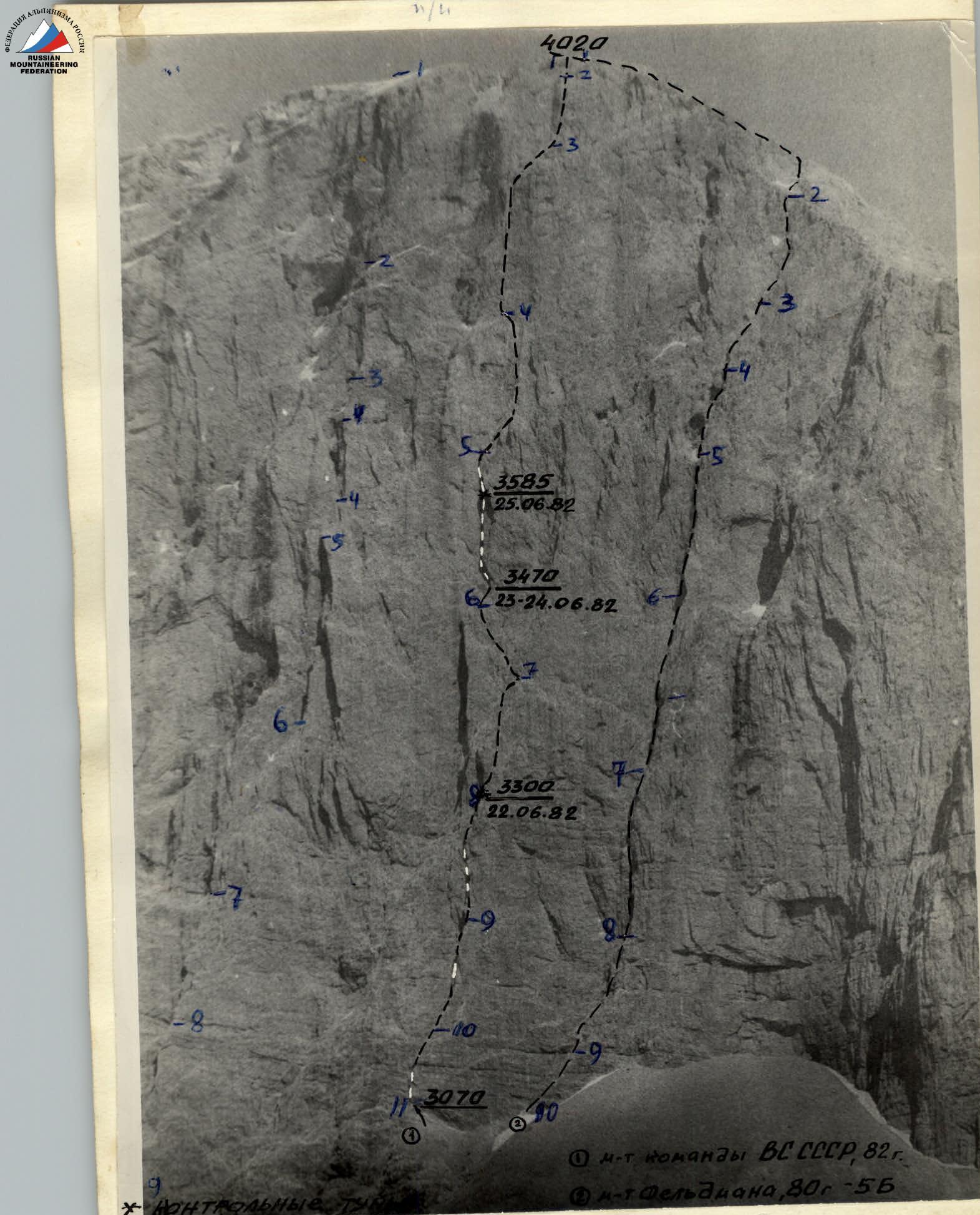
Date and time of shooting: June 10, 1982, 15:00 Lens: "Helios — 44 — M" Focal length: 58 mm Distance to the wall: 10 km Shooting point on the map: № I Height of the shooting point: 2600 m