Tactical Actions of the Team
The team's tactical actions were based on:
- available information about the routes (reports, photos, etc.);
- ensuring safety;
- experience in wall climbing.
The Leningrad team has been gathering information about the Erydag massif since 1980. Therefore, based on the available materials, observations of the wall during previous visits to the area, and experience climbing on this wall, a tactical plan for the ascent was developed (see sheet 6), which was fully executed during the ascent.
-
On August 3, 1987, at 5:00, the team, after preliminary processing of the first two ropes the day before, started on the route. Tsaruk works first. The other participants move along the fixed ropes.
-
In a day, 16 ropes were passed and one processed.
-
Overnight stay — comfortable, lying down, in a grotto (point 8), as planned according to the tactical plan.
-
On August 4, 1987, they started work at 7:00. Pasikhin works first.
-
By 14:00, the team reached a large ledge under the summit tower (point 13), and by 21:00, they reached the "roof," where they spent the night.
-
On August 5, 1987, at 6:00, the team climbed to the summit.
-
By 9:00, they returned to the base camp.
During the route, the team used the entire arsenal of modern technical means used in mountaineering. Emphasis was placed on free climbing. Artificial aids were used in only six places. The reliability and safety of the route were ensured by:
- all participants working on double ropes;
- the use of a tape shock absorber.
Based on consultations with first ascensionists, personal observations, and information from reports, the most rockfall-prone sections were identified. If the route is snowy or the weather is bad, the rockfall-prone sections are:
- a large ledge between the first and second bastions (point 5);
- rocks in the niche area (point 6).
Rocks fall onto these sections from the tower. In dry weather, particularly during the team's ascent, there is no objective rockfall danger.
Therefore, using adjustments to the base during the ascent and movement schedules of other teams (RSFSR-1 and RSFSR-2) on the NW wall, especially when these teams reached the "roof," the rockfall-prone sections 5 and 6 were passed quickly, by one person, and with observation.
The chosen tactics for passing rockfall-prone sections were fully justified during the ascent.
An additional safety measure was the "Base" being on hourly radio listening watch. Moreover, this allowed for necessary adjustments to the group's location and prevented deviation from the declared route, which proved useful on sections R9–R12 and R15–R17.
The equipment set and load distribution among participants (see sheet 9) were fully justified. All samples of homemade equipment were tested in Leningrad before departure to the mountains and tried out during a training session before the USSR Championship in the Uzunkol alpine camp.
The quantity of food and water taken for the ascent (see sheet 10) allowed the group to follow:
- the main variant of the tactical plan;
- the backup variant of the tactical plan.
As a result of precise planning and exact execution of the tactical plan, the ascent was completed without accidents, at a good pace (30 hours, including processing; the first ascensionists took 56 hours).
Senior coach of the LenGorsportkomitet team, Honored Master of Sports Team Captain, Master of Sports of the USSR
Shchedrin G. S. Bushmanov Yu. D.
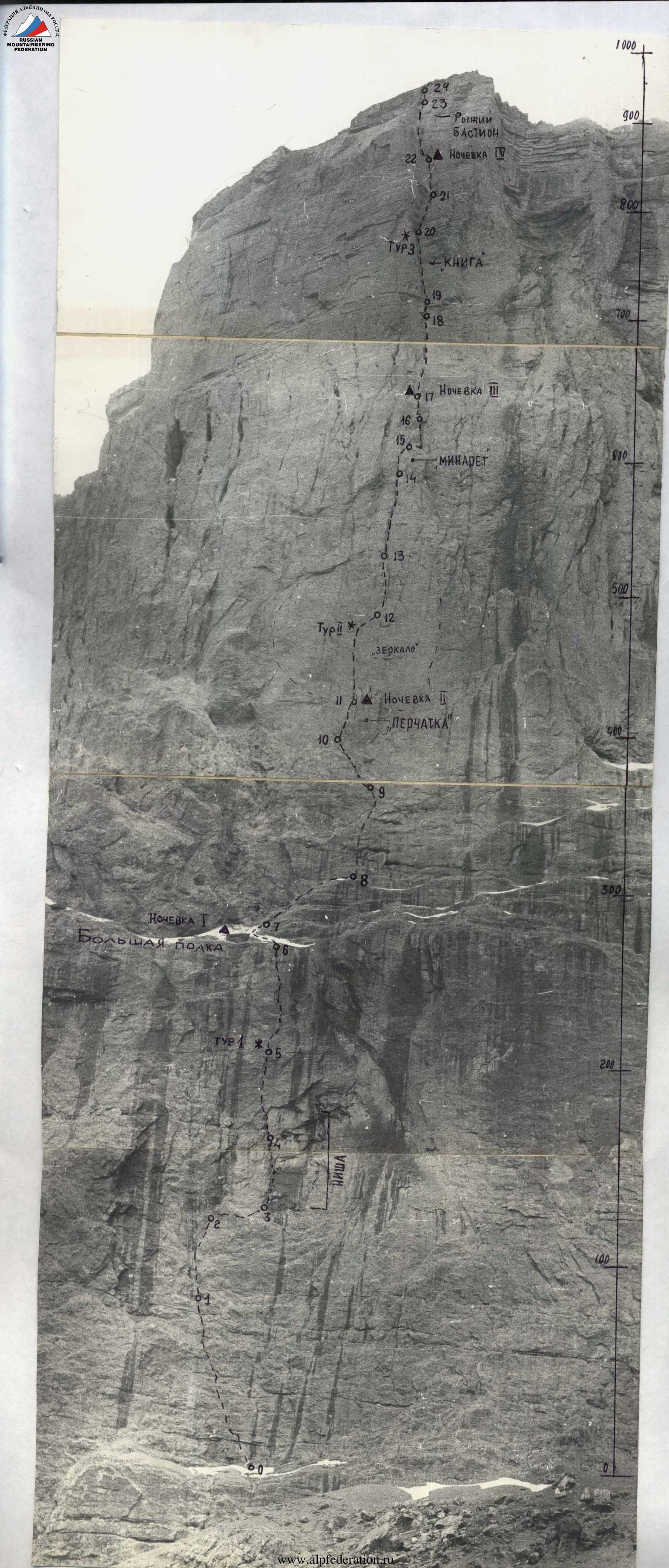
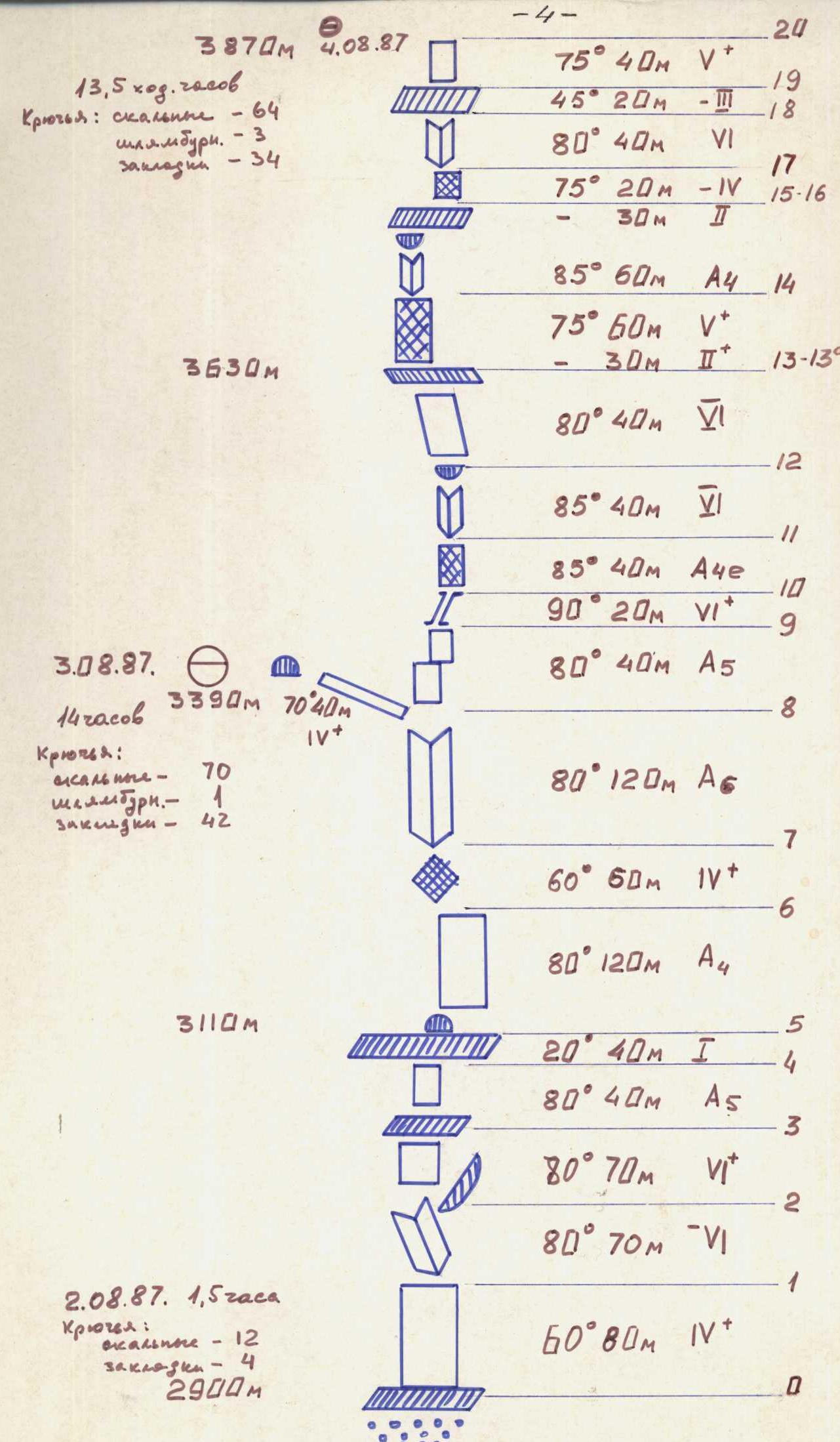
Table of Main Characteristics of the Ascent Route
Route length – 1220 m Length of most difficult sections – 865 m Average steepness of the route (wall) – 78°
| Date | Section | Section Length, m | Average Steepness, deg. | Terrain Description | Difficulty Category | Condition | Weather Conditions | Rock Pitons | Aids | Bolt Pitons | Chocks |
|---|---|---|---|---|---|---|---|---|---|---|---|
| June 15 | R0–R1 | 70 | 60 | inner corner with a flake | 4 | monolith | overcast | 4 | – | – | 3 |
| R1–R2 | 140 | 70 | wall with a series of inner corners and "ram's foreheads" | 4–5 | monolith | overcast | 8 | – | – | 10 | |
| Control checkpoint No. 1 on the ledge | |||||||||||
| R2–R3 | 70 | 100 | inner corner with an overhanging right wall | 5–6 | monolith | overcast, fog, hail | 7 | 4 | – | 6 | |
| R3–R3а | 30 | – | traverse right along the ledge | 4–5 | weak rocks, waterfall | good | 3 | – | – | 2 | |
| R3а–R4 | 30 | 80 | wall, "ram's foreheads" | 5 | live rocks | good | 4 | – | – | 5 | |
| R4–R5 | 40 | 40 | ascent along a large ledge | 1 | rockfall hazard | good | – | – | – | – | |
| June 16 | R5–R6 | 120 | 80 | right wall of a wide inner corner-gutter, exit to a large niche | 5 | many live rocks | – | 11 | 2 | – | 14 |
| R6–R7 | 40 | 70 | destroyed wall from the niche — left-up under the inner corner base | 4 | destroyed rocks, rockfall hazard | – | 2 | – | – | 3 | |
| R7–R8 | 120 | 95 | inner corner | 6 | monolithic rocks | – | 24 | 2 | – | 14 | |
| June 17 | R8–R9 | 70 | 70–80 | wall with a small gutter | 5–6 | monolith | overcast | 13 | –2 | 2 | 6 |
| June 18 | R9–R10 | 20 | 95 | narrow inclined chimney | 6 | wet, slippery rocks | good | 5 | 2 | – | 4 |
| R10–R11 | 40 | 85 | wall | 6 | "live" rocks, weak rocks | good | 5 | 2 | 2 | 2 | |
| R11–R12 | 40 | 80 | inner corner, 0.5 m cornice | 6 | rockfall hazard, "live" rocks, weak rocks | – | 4 | – | – | 8 | |
| R12–R13 | 70 | 80 | wall with ledges | 5 | weak rocks | – | 7 | – | – | 8 | |
| R13–R13а | 30 | – | exit to a ledge under the tower. Lying bivouac on the ledge. Traverse left along the ledge | 2 | large scree on the ledge | – | 2 | – | – | – | |
| R13а–R14 | 60 | 75 | wall exit under the inner corner with a cornice | 5 | rocks of block structure | – | 12 | 3 | – | 8 | |
| June 19 | R14–R15 | 60 | 85 | inner corner with a 1 m cornice, exit to a ledge | 6 | weak rocks of block structure | overcast, fog | 9 | 3 | – | 11 |
| R15–R16 | 40 | – | traverse along the ledge to the right | 1 | snow on the scree ledge | snow, fog | 2 | – | – | 1 | |
| R16–R17 | 20 | 75 | wall | 4 | "live" rocks, weak rocks | snow, thunderstorm, hail | 3 | – | – | 1 | |
| R17–R18 | 40 | 80 | icy inner corner with a crack | 6 | monolith, wet rocks | thunderstorm, wet snow | 8 | 2 | – | 3 | |
| R18–R19 | 30 | 45 | ledge | 3 | scree, snow | snow, wind, fog | 2 | – | – | – | |
| R19–R20 | 40 | 90 | yellow wall with a 1.5 m cornice. Exit to the edge of the wall. | 6 | weak rocks | snow, wind, fog | 6 | – | – | 8 | |
| R20–R21 | – | – | exit to the plateau via ledges and then along snowy fields to the summit. | 2 | – | wind, clear | simultaneous movement |
Total for the day: 380 m. Start time: 7:30, end time: 20:30. Total travel hours – 13. Total for the day: 280 m. Start time: 7:30, end time: 20:00. Total travel hours – 12:30. Total for the 3rd day: 70 m. Start time: 8:30, end time: 12:30. Working day duration – 4 hours. Total for the 4th day: 260 m. Start time: 6:30, end time: 20:30. Working day duration: 14 hours. Total for the 5th day: 230 m. Start time: 8:00. Reach the summit: 20:30. Duration of work to the summit 12.5 hours.
Route Sketch with Designations. Order of Route Passage (Brief Explanation to the Table of Main Characteristics)
On June 15, 1981, the first trio: Troshchinenko, Moshnikov, Barulin started working on the wall of the first belt at 7:30 after leaving the assault camp. Overcast. After contacting the base camp, the second trio started. First, they went left-up along an inner corner with a flake, and then along a wall with a series of inner corners to a ledge under a large cornice. 1st control checkpoint. Moshnikov goes first. Brief hail. Along an inner corner with an overhanging right wall, they exit to the upper right part of the cornice. Upward is a 30 m slab — shlambur work. Traverse right (30 m) and exit to a ledge, end of the first belt. Only three traversed; then, in the middle of the traverse, the waterfall intensified, and rocks started falling with the water. Therefore, the second trio reached the ledge via dropped ropes, bypassing the rockfall-prone section. While setting up a bivouac for six on the ledge under the cornice and preparing dinner, the first trio processed three ropes by the end of the day along the right wall of a wide inner corner-gutter. All day, weak rocks were frequently encountered. Boxes and chocks worked well. At 20:30, everyone was at the bivouac.
On June 16, 1981, they started at 7:30. Glushkovsky, Andreev, Shchedrin led. They passed the ropes hung the previous evening and, after tense climbing on destroyed rocks, exited to a niche where they planned to bivouac but found no water. Another rope on destroyed rocks (rockfall hazard) and exit to the base of an overhanging inner corner (R7–R8). Very difficult climbing. A small ledge for three. 19:00. They determined their location from a photo taken on the route. There should be a large niche, determine their location on the photograph. They saw that there was a large niche on the left. They made a traverse left-up and, after 40 m of "fifth-category" climbing, reached the niche with a large overhang. They set up a platform for four and hung a hammock on two bolts. 21:00 — everyone was at the bivouac. The bivouac was under an overhang, dry, with snow and water available. On the platform, four could sit, and two lay in the hammock.
On June 17, 1981, they started late at 8:30. Andreev, Moshnikov, Glushkovsky led. Overcast, light snow. They returned along the hung rope to continue the route at (R8) but didn't pull the rope leading to the niche for the bivouac yet. Unstable weather. Andreev passed a difficult wall and exited to the base of a narrow inclined chimney with an overhanging left wall (R8–R9). The group couldn't proceed further that day. Heavy rain with snow started. Fog. Rocks were covered in snow. At 12:30, the group stopped work and returned to the niche for the previous bivouac. Bad weather continued until the end of the day. During the forced wait, they improved the platform. The bivouac was relatively dry, at least not dripping from above.
On June 18, 1981, after such a long rest, they started on the route at 6:30. Moshnikov, Troshchinenko, Barulin led. They passed the ropes hung the previous day (R8–R9). After bad weather, there was a rockfall hazard, and one rope was damaged. R9–R10 — a narrow inclined chimney, difficult climbing, rime ice, slippery. At the exit from the chimney — the second control checkpoint. Then, right-up, a smooth wall (2 bolt pitons) (R10–R11) and then an inner corner with overhangs and a 0.5 m cornice (R11–R12). Live rocks, weak rocks. Another 70 m — and they passed the second rock belt, exiting to a ledge under the third. Now, all rocks flew over them. Barulin and Shchedrin led. They went to process the tower, while the others set up a bivouac on the ledge. It was impossible to climb the tower directly "head-on" due to cornices made of very weak, unstable rocks along the entire wall, making it impossible to ensure safe passage. Therefore, they made a traverse left along the ledge (R13–R13а) and then, along the wall with "live" rocks and sections of weak rocks, exited under an inner corner with a cornice. They hung ropes and, by 21:00, the processors descended to the bivouac. The bivouac was lying down and again under a canopy.
On June 19, 1981, it was overcast, foggy. They started from the bivouac at 8:00. Troshchinenko, Glushkovsky, Andreev led. They passed the ropes hung the previous evening and exited to section R14–R15 — an inner corner with a 1 m cornice. Difficult climbing, AID, weak rocks of block structure encountered. Then, they exited to a ledge and traversed right along it (R15–R16). Again, bad weather: snow, fog. Around 14:00, a thunderstorm started, lasting 2 hours. They continued moving. R16–R17 — a wall that seemed made of "live" rocks. R17–R18 — an icy inner corner with a crack, very difficult climbing, rocks smooth, wet, icy. The thunderstorm continued. They exited to a snowy scree ledge. Ascent along it (R18–R19). Wet snow continued to fall. Fog. The last section of the wall, R19–R20 — a yellow-colored wall with a 1.5–2 m cornice, weak rocks. The cornice was bypassed on the left, and they exited to the top of the wall. The snow stopped, and the fog cleared. Simultaneously, they moved along snowy ledges to the pre-summit ridge and then along snowy fields to the summit. At 20:30, the LenGorsportkomitet team climbed the 1st Western summit of Erydag, completing a first ascent along the center of the left part of the NW wall. Since everyone was thoroughly wet, and the descent route was well-known, plus it was a full moon, they decided to descend to the base camp without delay. After descending without incident, the team returned to the base camp on June 20, 1981, at 1:30.
Scheme of the Wall Part of the Route
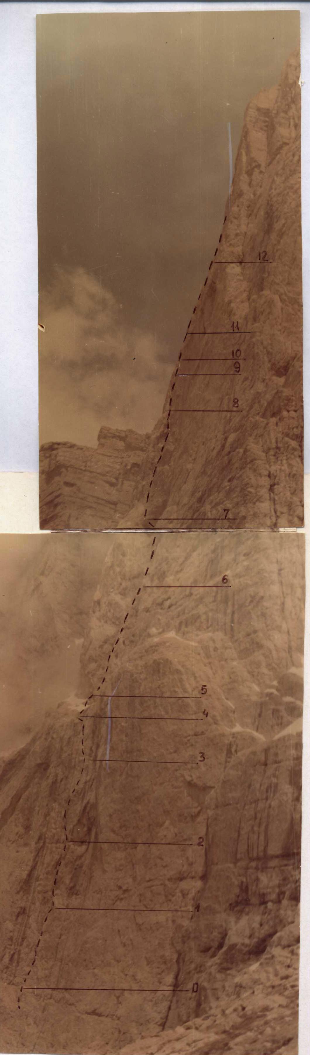
Profile of the Wall Part of the Route
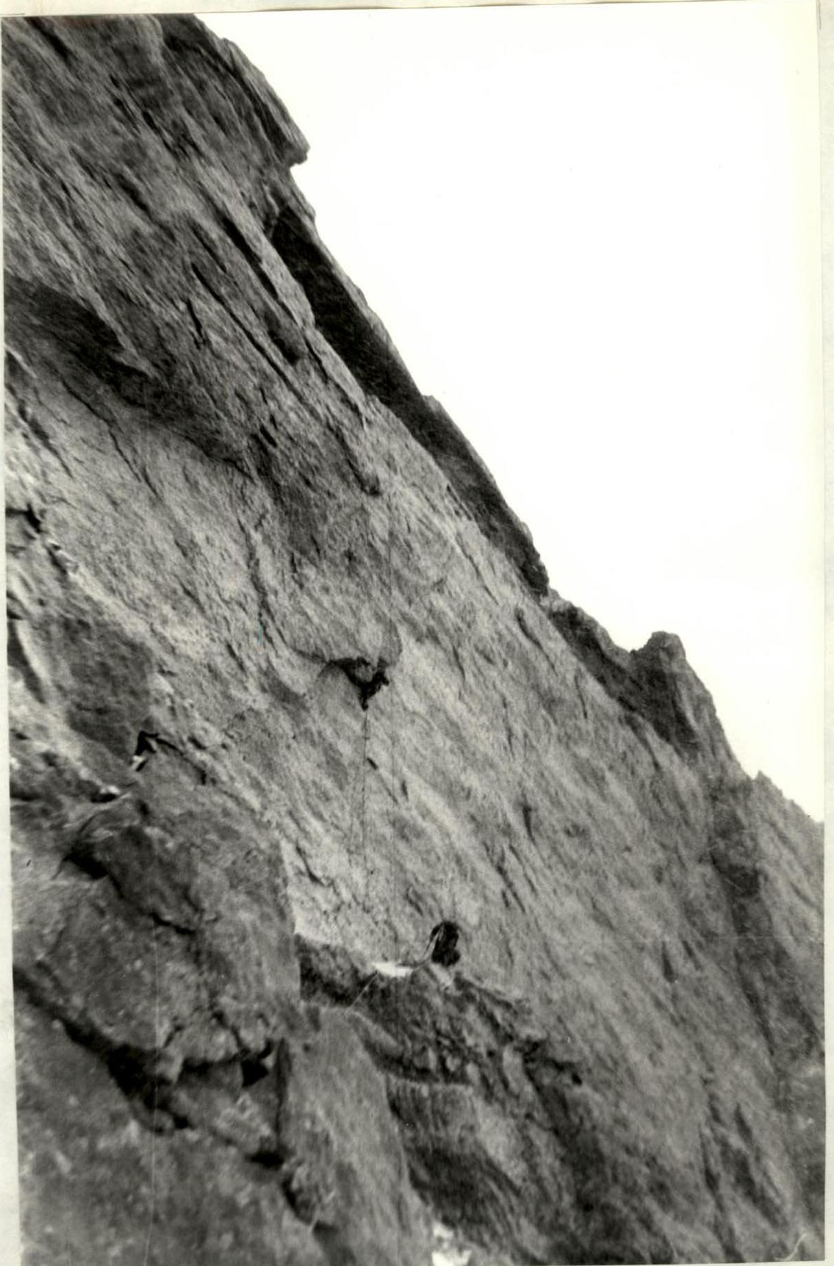
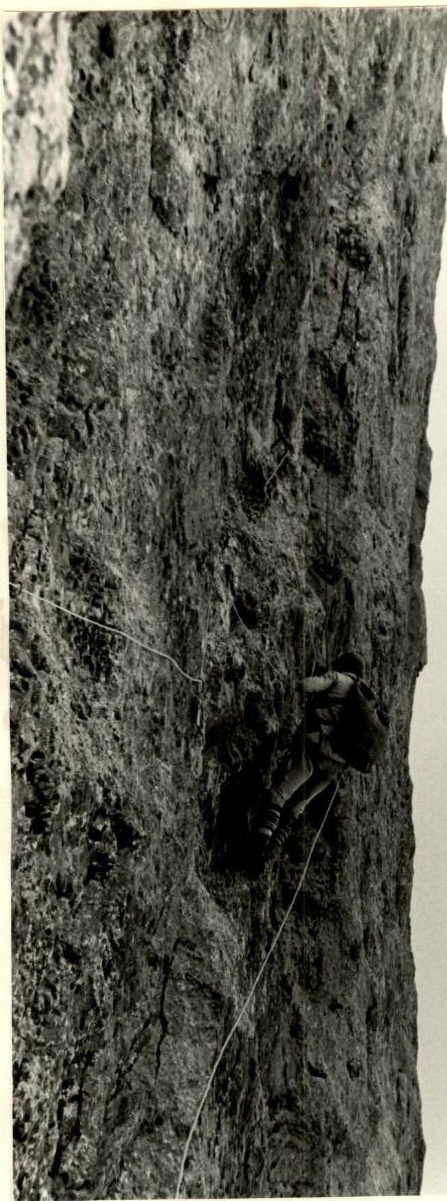
Section R1–R2. Beginning of the wall with a series of inner corners.
Section R2–R3. Inner corner with an overhanging right wall.
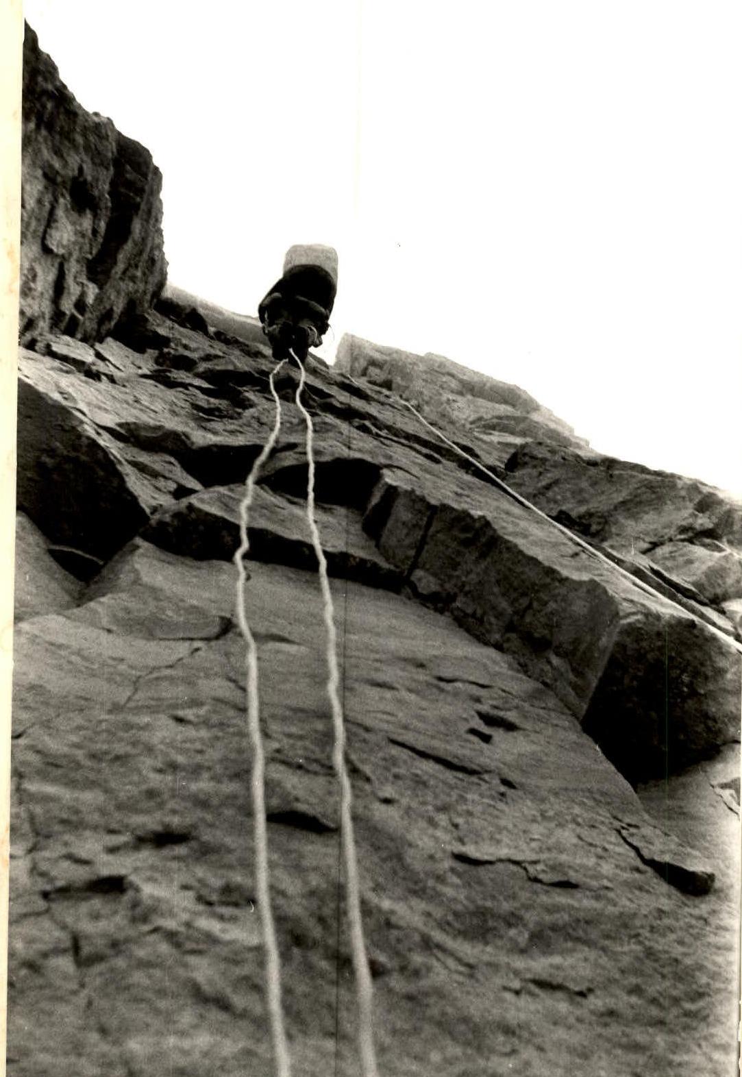
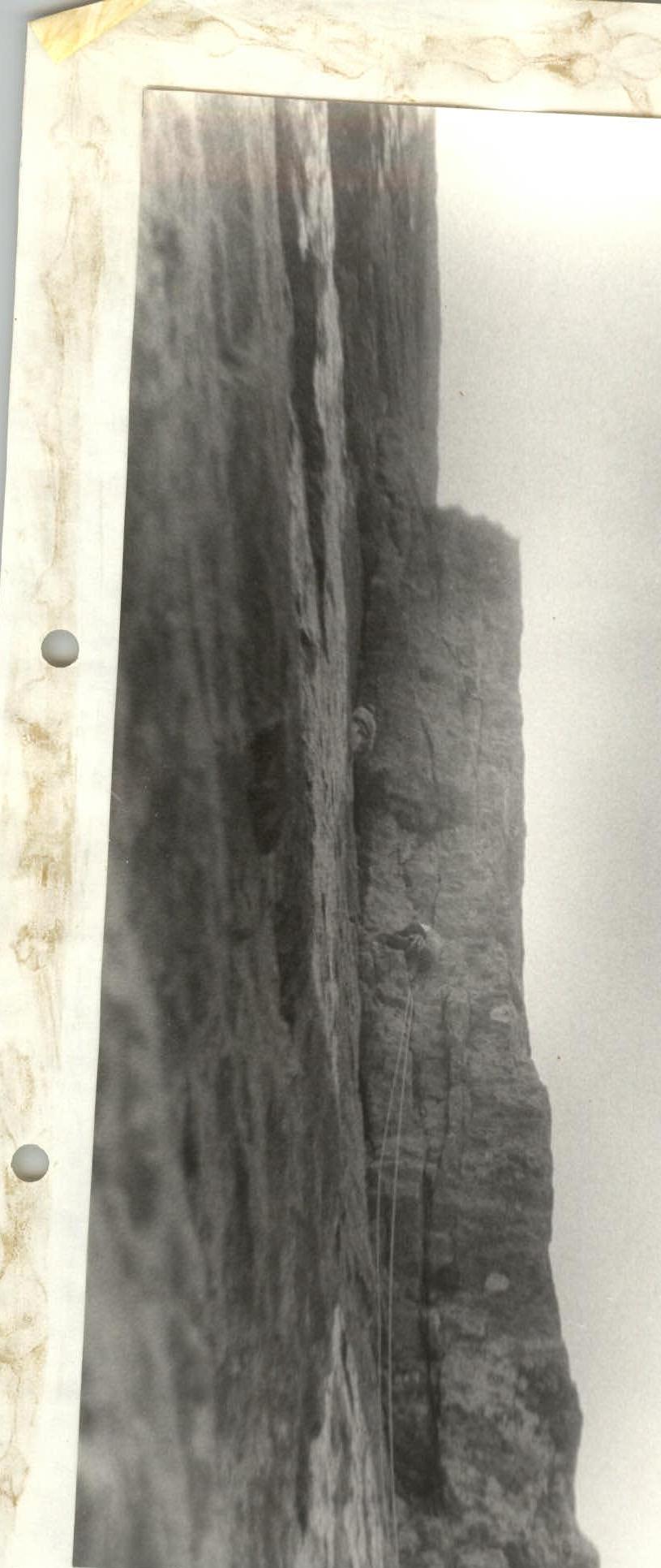
Section R11–R12. Exit to the base of the inner corner. A. Moshnikov is working.