Passport
-
Rock class
-
Eastern Caucasus.
-
Peak Yarydag
-
6th category of difficulty
-
Height difference 950–970 m.
-
Length of sections: 5th and 6th category of difficulty — 930 m (5 – 350 m, 6 – 580 m).
-
Average steepness 79–80°.
-
Pitons driven: rock 86 (26 ITO), bolted 2 (6 ITO), chocks 69 (73 ITO).
-
Climbing hours — 43.5 h.
-
Overnight stays: 1 — wide ledge under an overhanging rock. 2 — in hammocks, 3 — two on a small ledge, four in hammocks, 4 — a ledge laid out for six.
-
Team leader — Yefimov Sergey Borisovich, Master of Sports Team members:
- Lebedikhin Alexey Veniaminovich, Master of Sports
- Samoilin Mikhail Alexeyevich, Master of Sports
- Vinogradsky Yevgeny Mikhailovich, Master of Sports
- Bryksin Valery Mikhailovich, Master of Sports
- Abramov Sergey Semyonovich, Master of Sports
-
Coach — Yefimov S.B.
-
Start of the route — June 20, 1981. Return — June 24, 1981.
-
Route of the Ukraine team
-
Route of the Leningrad team
-
Route of the Sverdlovsk team (RSFSR)
-
Route of the Moscow team
Introduction
Peak Yarydag 4110 m is located 20 km south of the settlement of Usukhchai. This peak has gentle snowy slopes facing north, south, and east, while to the west it drops off with a wall stretching for several kilometers. The wall has a bend:
- The northern (left) part has a northwest orientation,
- the central part, where the main and first western peaks are located, — western orientation,
- the southern (right) end of the wall — southwest orientation.
In the summer of 1981, the right and left parts of the wall were mainly being explored, with the complexity and length of the routes increasing as they approached the central part. This central part, with the maximum height difference and highest complexity, became the objective for five teams competing in the rock class of the USSR Championship.
Tactical Preparation
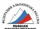
Upon examining the photograph of the wall, we were drawn to a route that leads to the highest point of the wall via a series of internal, arcuate angles going from right to left, resembling a sickle shape in the photograph, with the handle starting in the first third of the route and the tip reaching the top of the wall through a giant internal angle (which we called the "book"). The lower third of the route is a 300-meter wall with a steepness of 75 to 85 degrees in its upper part. This route is located in the middle part of the massif of the first western peak, with its right part appearing technically less complex. To the left, along the edge of the massif, another interesting and logical route was visible, which, as we knew, was planned by the Leningrad team. Between the "sickle" and the edge, a completely smooth, concave part of the wall, known as the "mirror", was visible, and we deemed it impossible to climb.
Thus, our main focus became the "sickle" route. Upon arrival, we confirmed our assessment and began to develop a detailed plan for climbing this route. However, the Moscow team also targeted the "sickle", and the draw gave us the second number. We hadn't even registered for the main peak, considering the route to it to be shorter, so we were faced with a choice:
- either to take the right part of the massif, which was technically weaker,
- or to attempt to pass through the "mirror".
After additional reconnaissance, we decided to go with the second option. However, in the upper part, we would have to cross the Moscow team's route and go to the right (later, the Moscow team moved to the right, and we were able to complete our route logically straight up through the "book").
The tactics on the route included:
- Fixing ropes by the first climber in the leading team and the rest climbing on jumars with backpacks.
- Rotating the leading team every day.
- Whenever possible, processing the next section one or two ropes ahead after setting up camp.
Reconnaissance
Before the Championship, the team made an acclimatization ascent to the peak of Shalbuzdag via a category 2B route, from which a series of photos and sketches were taken, allowing for an accurate understanding of the proportions of different sections of the wall, necessary for a realistic tactical plan. Additionally, a training ascent was made to the 1st western peak of Yarydag via a category 5A route, and three reconnaissance trips were made under the wall. After which, the following tactical plan was drawn up:
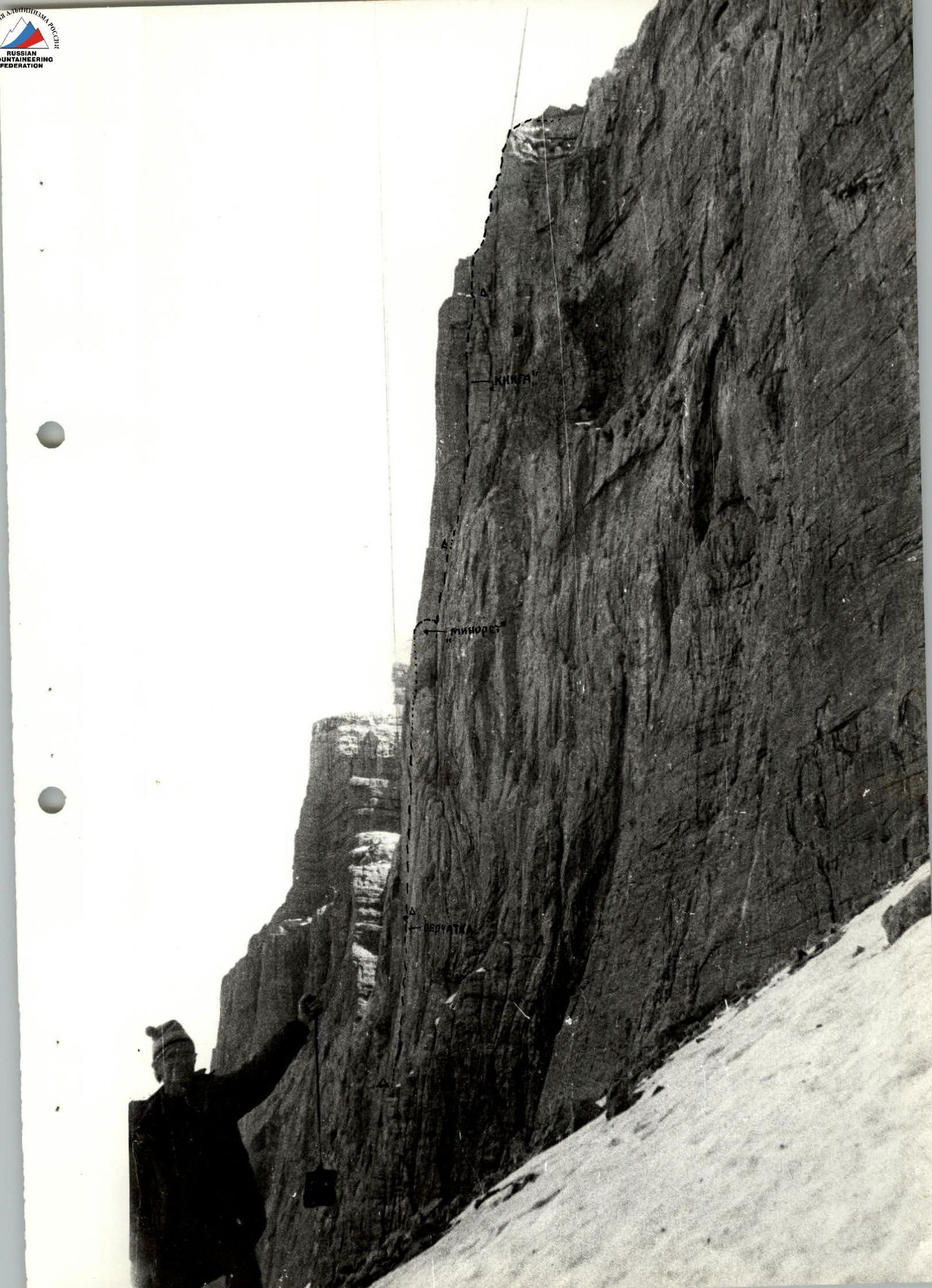
- Day one — reaching a large ledge,
- day two — reaching the "minaret",
- day three — reaching the base of the "book",
- day four — reaching the area of yellow rocks under the peak,
- day five — ascending to the peak and descending to the base camp,
- day six — a reserve day for bad weather.
Already on the second day, bad weather made adjustments to the plan. Six hours of waiting out heavy rain with wet snow under the "mirror" forced an unplanned overnight stay. Later, it was possible to compensate for this delay.
Route Description
The entire route can be roughly divided into three parts:
- reaching a large ledge (about 300 m). The most challenging part of this section is the path from the niche to the exit onto the ledge;
- reaching under the giant internal angle "book" (400 m). The most problematic part of this section was passing the smooth part of the wall, known as the "mirror", and reaching the "minaret" — a rock section in the upper part of the "sickle", rimmed with cracks and resembling a minaret dome;
- ascending to the peak of the wall via the "book", "through a series of internal angles with corks" (250 m).
On June 20, at 8:00 AM, the team of Yefimov — Lebedikhin started. From the snowy ledge, the route went up and slightly to the left under an internal angle, leading to a "niche" (rust-colored rocks, seemingly pressed into the wall). To the internal angle (R1), complex climbing was required on a wall with rounded relief. The rocks were wet in places. Large universal pitons and stoppers were used for protection. (90 m, 75°).
The internal angle (R2) led to a "niche". It was filled with water. Slippery. Climbing was complex. (40 m, 75–80°).
20 meters before the end of the angle, we traversed right and up along a barely noticeable ledge to the base of the "niche" (R3).
The exit from the "niche" was via its left edge, forming an overhanging internal angle, the lower part of which was filled with water, and the upper part (rust-colored rocks with spiky needles) ended with a cork. Climbing with ladders. Very complex climbing (R4, 40 m, 90°).
Further, the path went vertically up: first through a crack formed by a rock overhang (35–40 m, 80°), using ladders three times (R5). When the crack ended — up a wall with very weak relief, extremely complex climbing on a section of 90 m with a steepness of 85–87°.
In the middle part — an awning (R6), with 3 bolted pitons, using ladders three times (thin pitons and small stoppers). Weather conditions:
- fog,
- light rain starting.
For the day, 8 ropes were covered. We reached the ledge (R7) at 5:30 PM.
While organizing the camp under an overhanging rock, the pair Samoilin — Lebedikhin went for further processing and fixed another three ropes in 1.5 hours. It was drizzling.
The wide (20 m) ledge allowed for movement without protection. We didn't want to sleep on the snow, so we moved left 40 m under a rock awning.
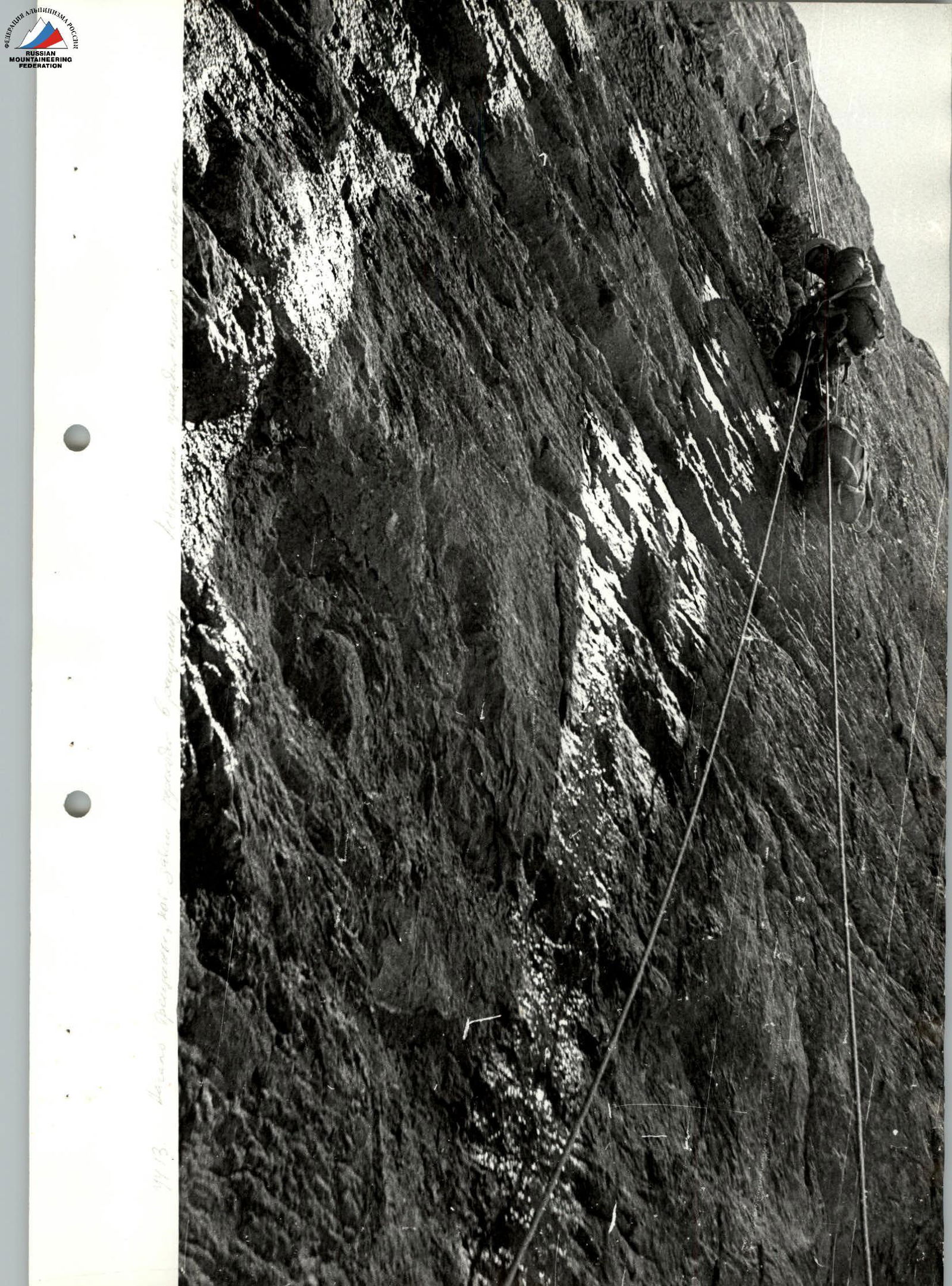
At 7:30 AM, the first team, Samoilin — Yefimov, started working towards a rock overhang resembling a 40-meter glove under the base of the "mirror". From the overnight stay, the route went along an inclined ledge with easy climbing under the wall (40 m, R8). Then up the wall 80 m (R9), with steep smooth walls of 15–20 m and a steepness of 80°, intersected by narrow ledges (complex climbing). Further, along an internal angle to the base of the "glove" 40 m, 80° (R10). Climbing of medium difficulty. Reaching the "glove" (R11) via an internal angle 30 m, 80°. We reached the "glove" at 10:40 AM. At 11:00 AM, Yefimov stepped onto the "mirror". A barely noticeable crack started 10 m from the top of the "glove" and went up for 40–50 m. This was the only feasible path. All around was smooth monolith. Above, 200 m away, the yellow rocks of the "minaret" were visible. A Bryksin measured the angle to the "minaret" from the edge of the "glove" — 85°. However, even during heavy rain, the yellow rocks under the "minaret" remained dry, meaning the entire crack leading from the "mirror" to the "minaret" smoothly overhangs. This was about 100 m.
The first climber, using wall irregularities and a skyhook, managed to reach the crack. After 1.5 hours of work, having climbed 20 m purely on chocks and ladders, Yefimov, completely wet, had to descend. Heavy rain with snow started. Until 6:00 PM, we waited out the bad weather under a polyethylene canopy. We had to spend the night there. From 6:00 PM to 8:00 PM, the team of Yefimov — Lebedikhin processed another 50 m of the "mirror" (R12). Collecting rainwater with a polyethylene sheet, we cooked dinner. We had water in flasks for the next day.
On June 22, we started at 7:30 AM. The first team to work was Lebedikhin — Yefimov. After passing the fixed ropes, Lebedikhin began working on the vertical part of the "mirror" (R13). The crack disappeared and reappeared. 50 m, 90°. Mostly ladder work. Further, the crack widened into a crevice (R14), which smoothly overhung. 40 m, 95°. The last 15 m (R15, reaching the "minaret") had an overhang of up to 100°. We passed this section purely on ladders (piton, chocks).
R16 (40 m, 80°) was the "sickle's" chimney, passed in a layback under a cork. The entry to the cork was via ladders. R17 led to a ledge via an internal angle (20 m, 85°). Complex climbing. While stretching hammocks and preparing dinner, Samoilin processed 40 m up the wall.
On June 23, the team of Lebedikhin — Samoilin went up from the overnight stay to the base of the internal angle "book" — R18. 80 m up the wall, 75–80°. Complex climbing. Small holds. The entry into this 100-meter "book" started with a 7-meter overhang (R19), 95°, very complex climbing (ladders were used). Samoilin, having quickly passed this section, fixed a rope and organized a belay on a small rock overhang. The rocks were strong, monolithic, with small holds. From above, the internal angle was closed by a roof. Under the roof, there was a small narrow ledge; to reach it, we had to extend the rope. The total length of this section (R20) was 90 m, 75–80°. Further, the path lay along the right wall of the angle, bypassing the "roof" on very weak relief (the wall was smooth, R21). Very complex climbing, 40 m of which led to a second, smaller internal angle. And again, the entry was an overhanging half-meter cornice. R22 was also passed in laybacks. The next very destroyed ledge served as a bivouac site. We laid out a platform, hung a polyethylene canopy, and just then, a thunderstorm started. Some time later, the team of Bryksin — Samoilin descended from above. The severe thunderstorm didn't allow them to process the second rope. The working day, including processing, totaled 8.5 hours.
June 24. 7:00 AM. The first team to go was Yefimov — Samoilin. The wet snow from yesterday's thunderstorm had turned to ice, thinly covering significant parts of the rock. Climbing became even more difficult. R23 from the ledge was a 60-meter wall, 75–78° in the upper part, ending with a 10-meter rock block. Climbing was difficult. Further, after a meter-wide icy ledge — a wall 20 m, 85° (R24). Very complex climbing. Ladders were used.
And after — along snowy ledges through small three-meter walls upwards on the wall (easy climbing). To the peak led a gentle snowy path. The descent to the halt took no more than an hour.
Table of Main Characteristics of the Ascent Route
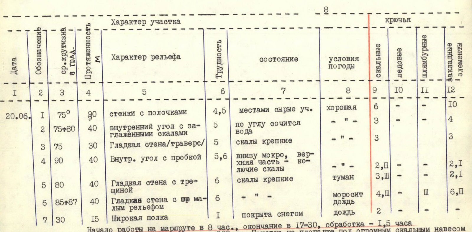
| Date | Notation | Avg. Steepness in ° | Length, m | Character of Section | Difficulty | State | Weather Conditions | Rock Pitons | Ice Pitons | Bolted Pitons | Chock Stones |
|---|---|---|---|---|---|---|---|---|---|---|---|
| 20.06. | 1 | 75 | 90 | Walls with ledges | 4.5 | Wet sections in places | Good | 6 | - | - | 10 |
| 2 | 75–80 | 40 | Internal angle with smoothed rocks | 5 | Water oozing along the angle | " | 3 | - | - | 4 | |
| 3 | 75 | 30 | Smooth wall/traverse/ | 5 | Rocks firm | " | 3 | - | - | 3 | |
| 4 | 90 | 40 | Internal angle with cork | 5,6 | Bottom wet, upper part spiky rocks | " | 2 (2 ITO) | - | - | 2 (1 ITO) | |
| 5 | 80 | 40 | Smooth wall with crack | 6 | Rocks firm | Fog | 3 (3 ITO) | - | - | 2 (1 ITO) | |
| 6 | 85–87 | 40 | Smooth wall with very weak relief | 6 | " | Light rain | 4 (3 ITO) | - | 3 (ITO) | 6 (2 ITO) | |
| 7 | 30 | 15 | Wide ledge | 1 | Covered with snow | Rain | 2 | - | - | - | |
| Start at 8:00 AM, finish at 5:30 PM, processing — 1.5 h. Climbing hours — 11 h. Height difference — 300 m. Overnight on a site under a huge rock awning. | |||||||||||
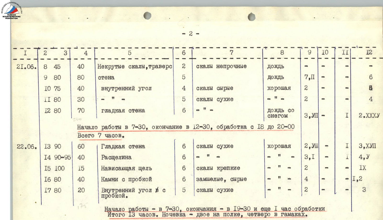
| 21.06. | 8 | 45 | 40 | Gentle rocks, traverse | 2 | Rocks unstable | Rain | - | - | - | - |
| 9 | 80 | 80 | Wall | 5 | " | Rain | 7 (2 ITO) | - | - | 6 | |
| 10 | 75 | 40 | Internal angle | 4 | Rocks wet | Good | 2 | - | - | 4 | |
| 11 | 80 | 30 | " | 5 | Rocks dry | " | 2 | - | - | 4 | |
| 12 | 80 | 70 | Smooth wall | 6 | " | Rain with snow | 3 (7 ITO) | - | 1 (ITO) | 2 (35 ITO) | |
| Start at 7:30 AM, finish at 12:30 PM, processing — from 6:00 PM to 8:00 PM. Total 7 h. | |||||||||||
| 22.06. | 13 | 90 | 60 | Smooth wall | 6 | Rocks dry | Good | 2 (8 ITO) | - | 1 (ITO) | 3 (17 ITO) |
| 14 | 90–95 | 40 | Crevice | 6 | " | " | 3 (1 ITO) | - | 1 (ITO) | 4 (5 ITO) | |
| 15 | 100 | 15 | Overhanging crevice | 6 | Rocks firm | " | 2 | - | - | 9 (ITO) | |
| 16 | 80 | 40 | Rocks with cork | 6 | Mossy, wet | " | 4 | - | - | 1 (ITO), 2 | |
| 17 | 80 | 20 | Internal angle with cork | 5 | Rocks dry | " | 2 | - | - | 3 | |
| Start at 7:30 AM, finish at 7:30 PM and another 1 h of processing. Total 13 h. Overnight: two on a ledge, four in hammocks. | |||||||||||
| 23.06. | 18 | 75–80 | 80 | Wall with small holds | 5,6 | Rocks firm, dry | Good | 8 | - | - | 7 |
| 19 | 95 | 7 | Cornice | 6 | " | " | - | - | - | 1 (ITO) | |
| 20 | 78–80 | 90 | Smooth internal angle | 6 | Water oozing along the angle | Good | 10 | - | - | 1 (ITO) | |
| 21 | 75 | 30 | Internal angle | 5 | Rocks destroyed | " | 3 | - | - | 2 | |
| Start at 8:30 AM, finish at 3:30 PM and another 1.5 h of processing. Total 8.5 h. Overnight on a ledge for six. | |||||||||||
| 24.06. | 23 | 75–78 | 60 | Wall of bastion | 5 | Rocks not firm | Sleet | 5 | - | - | 2 |
| 24 | 85 | 20 | Wall | 5 | Rocks icy | Cold, sun | 31 | - | - | 1 (ITO) | |
| 25 | 60 | 80 | Traverse along snowy ledges and short walls | 4 | Snow, ice | Good | 2 | - | - | - | |
| Start at 7:00 AM, finish at 10:30 AM, walked 1 h on snow. Total 4 h. |
Total climbing hours — 43.5 h.
Number of rock pitons — 112 (including 26 ITO).
Number of bolted pitons — 8 (including 6 ITO).
Number of chock stones — 142 (including 73 ITO).
Average steepness — 80°.
Height difference — 950 m.
Route length 1140 m.

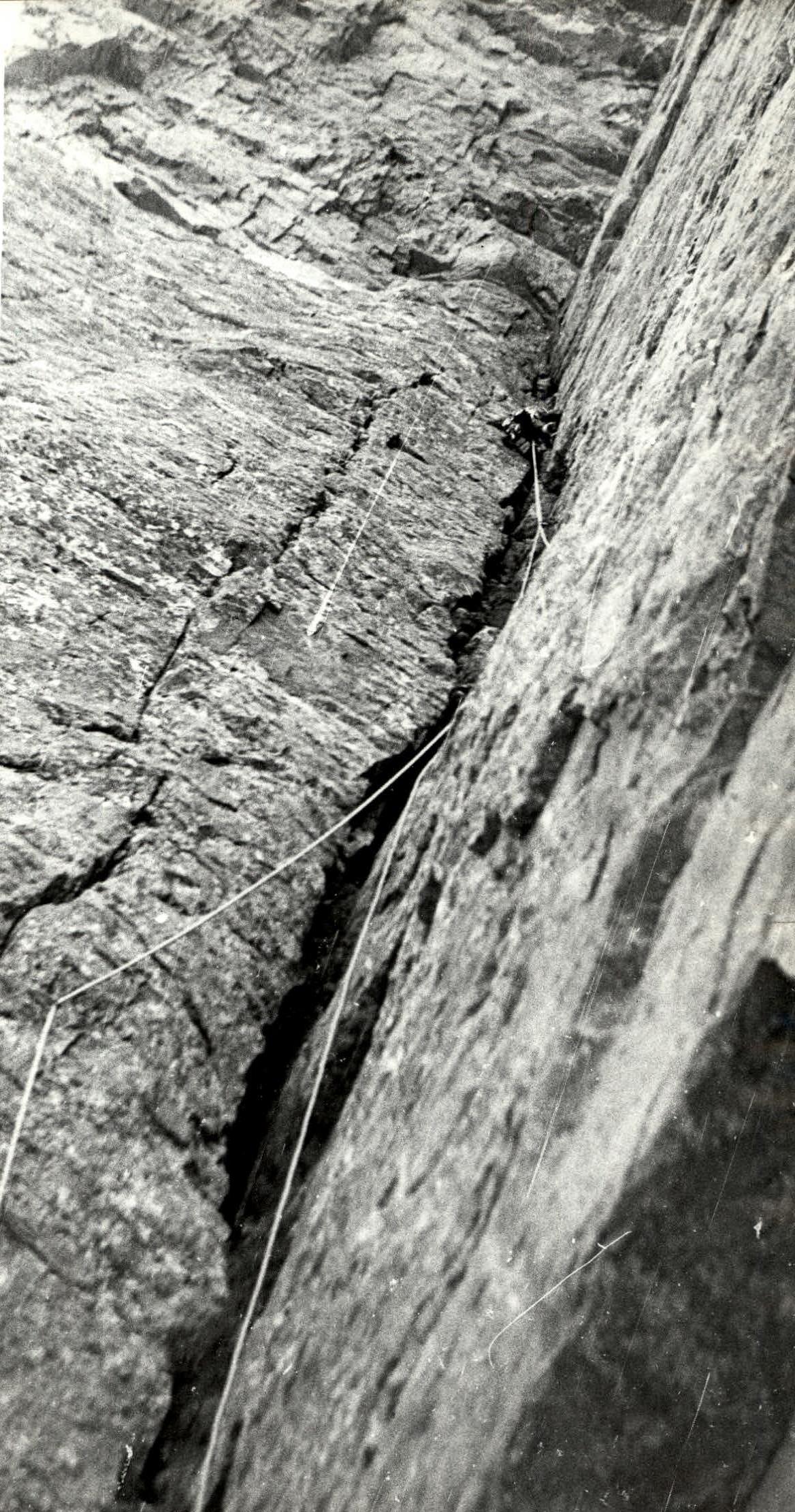
Start of the crack, which then turns into a crevice.
Lebedikhin is climbing on fixed ropes with a backpack.
R20. Upper part of the "book". Samoilin is exiting under the roof of the "book".