ASCENT DOCUMENT
- Class of winter ascents.
- Region 2.10 Mountains of Dagestan.
- Erydag, 3925 m, via the center of the bastion on the West wall, first ascent, rock route.
- Proposed — 5B category of difficulty.
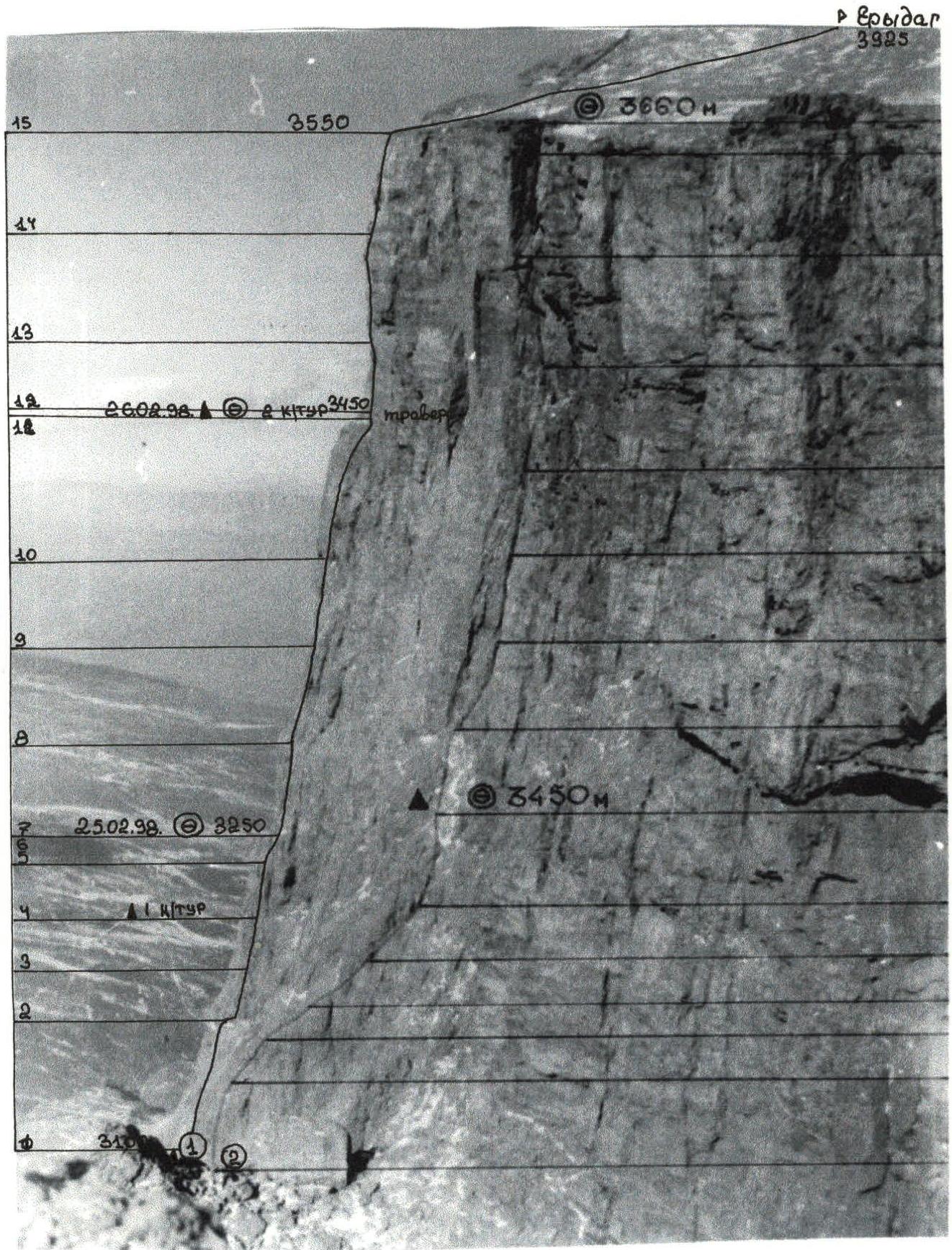
- Route characteristics: height difference of the wall section — 450 m, total — 825 m, length of the wall section — 640 m, total — 2140 m, length of sections with 5th category of difficulty — 325 m, 6th category of difficulty — 80 m, average steepness of the route — 70 degrees.
- Equipment used on the route:
- rock pitons: 88/15
- chocks: 40/10
- friends: 7/5
- bolt pitons: 13/9
- ice screws: 0/0 Left on the route:
- rock pitons: 2
- bolt pitons: 2
- Team's travel days — 4; hours — 32; including preliminary processing — 8.
- Overnights:
- first — in the assault camp below the route;
- second — on a rock shelf in a tent on a prepared platform;
- third — on a rock shelf in a tent on a prepared platform;
- Team members:
- Smotrov Sergey Ivanovich — Candidate Master of Sports
- Nurbagandov Gadzhimurad Musaevich — Candidate Master of Sports
- Coach: Murtazaliev Ziyabudin Murtazalievich.
- Departure from "Erydag" base camp: February 23, 1998. Summit: February 26, 1998. Return to "Erydag" base camp: February 26, 1998.
- Organization: Dagestan Republican Rescue Service of the Ministry of Emergency Situations of Russia.
GENERAL PHOTO OF THE SUMMIT
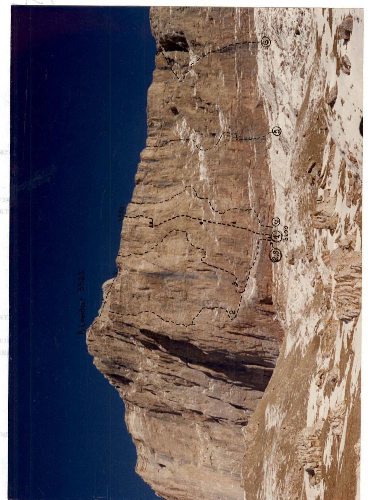
1 — Team's route
Δ — control point
• — overnight stays
2 — Polyakov's route, 80, via the left edge, 3rd category, 5B category of difficulty.
3 — Samoded's route, via the center of the 3rd category through "feathers", 5B category of difficulty.
4 — Novikov's route, 86, via the center of the left part of the 3rd category, 5B category of difficulty.
5 — Dubovikov's route, 81, left part of the NW wall, 5B category of difficulty.
6 — Nezamutdinov's route, 79, on the wall, 5A category of difficulty.
The photo was taken on February 23, 1998.
- The photo was scanned from Novikov's report, 86, via the center of the left part of the 3rd category, 5B category of difficulty.
TACTICAL ACTIONS OF THE TEAM
To participate in the Winter Championship of Russia in alpinism, it was decided to send a team of two. The decision was influenced by the team's mobility and the possibility of scoring the maximum number of master points.
For the ascent, the team chose a new route on Mt. Erydag via the bastion on the West wall, between the already known routes:
- Samoded's route through "feathers" on the left side;
- Nekrasov's route on the right.
Both routes are classified as 5B category of difficulty. The planned route was attractive due to its logic, steepness, and directness.
Previously, the team had completed:
- Kovtun's route on Mt. B. N Khar — 6B category of difficulty (rock class);
- Lukashvili's route on Mt. Kyukyurtlyu — 6B category of difficulty (technical class).
Before departing, the team underwent general physical training, rock climbing, snow, and ice training at the выездnye seminars of the Dagestan Republican Rescue Service.
Upon arrival in the village of Kurush, Dokuzparinsky district, Republic of Dagestan, on February 17, they set up camp at the "Erydag" training base of the Dagestan Republican Rescue Service.
After a training ascent on Mt. Sel'dy, they established an assault camp under the West wall, within a 15-minute walk from the route.
On February 23, the team of Nurbagandov G. and Smotrov S. began processing the route. The movement scheme was classic:
- The first climber moved on a double rope;
- one rope was imported and met UIAA standards;
- the second rope was Soviet-made and was attached after 40–50 meters as a fixed rope.
On that day, they fixed two ropes; on the next day, February 24, the team started the route, taking all necessary equipment for rock climbing and overnight stays.
The first climber wore rock shoes. Two fixed ropes were used, one of which was dropped after being passed. Communication with observers — Velikanov V.V., Master of Sports, Kurbanov K.M., 1st sports category, and the rescue team in the base camp — was maintained via a VHF radio station "Standard".
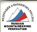
The tactical plan included the first overnight stay on a horizontal ledge after the first bastion. After working on three more difficult pitches of the 1st bastion, they reached a horizontal ledge — the site of the first overnight stay.
The bastion was very difficult to climb, with extensive use of artificial technical aids (IT). At the stations, they used bolt pitons (screw-in type). The remaining 1.5 hours of daylight were used to process the route — 40 m and set up a bivouac. The overnight stay was safe, under a rock overhang.
On February 25, they began moving along the fixed ropes — Smotrov — Nurbagandov. The rocks were fragile, requiring great caution. There was extensive use of pitons and chocks. After three pitches, they reached the site of the second planned overnight stay.
On February 26, after traversing 25 m to the right and then climbing three pitches on steep and complex rocks, they reached the plateau. Then, they followed a 1B category route to the summit of Mt. Erydag. They descended to the base camp together with the observers in the dark.
The tactical plan was executed.
The team completed the ascent with an overnight stay below the route and two overnight stays on the wall, after a day of processing. They extensively used rock pitons, chocks, and friends. At the stations, they tried to use screw-in bolt pitons. Communication with observers and the base was regular. The route was completed with two batteries for the "Standard" radio station.
The base camp housed a rescue team consisting of:
- two Candidate Masters of Sports in alpinism;
- four with 1st sports category.
Also present in the base camp were:
- PSS-1 team, participating in the XVI Russian Alpinism Championship in the winter class on Mt. Shalbuzdag;
- a ZIL-131 PPU vehicle with a HF radio station and communication with the base in Makhachkala;
- a doctor;
- a quartermaster.
The team completed the route with a reserve of physical and moral strength, as well as food supplies.
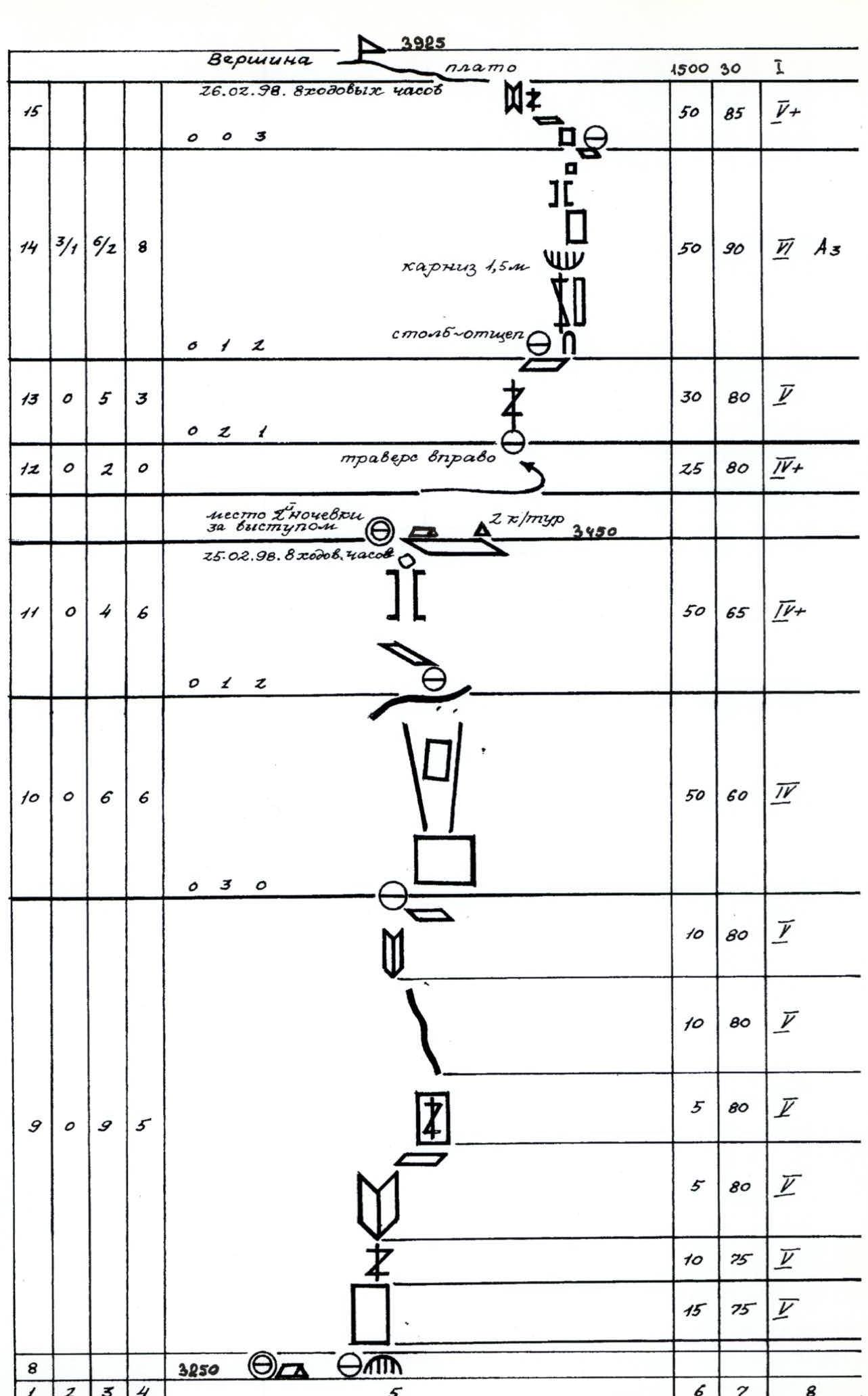
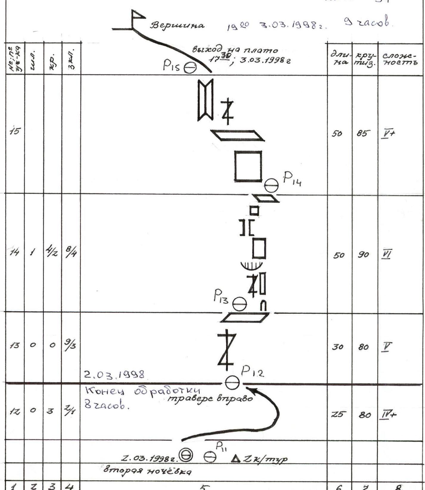
Route scheme in UIAA symbols. Scale 1:2000
| Section № | bolt pitons | chocks | ice screws | Used at stations: bolt pitons; pitons; chocks; | Length | Steepness | Difficulty |
|---|---|---|---|---|---|---|---|
| 8 | 0 | 8 | 4 | (site of 1st overnight stay, orientation point) | 40 | 80 | 1 |
| (February 24, 1998, 8 travel hours) | |||||||
| 7 | 0 | 1 | 2 | (0 3 0) | 40 | 50 | 3 |
| 6 | 0 | 0 | 3 | (0 2 1) | 35 | 50 | 3 |
| 5 | 0 | 8/4 | 4 | 10 | 85 | 4+ Az | |
| 12 | 75 | 5 | |||||
| 10 | 75 | 5 | |||||
| 12 | 75 | 5 | |||||
| (0 2 1) | 6 | 80 | 4+ Az | ||||
| 4 | 3 | 7 | 3 | (2 1 0) | 45 | 80 | 1 Az |
| 3 | 6 | 5/2 | 5/2 | (1 2 0) | 10 | 85 | 1 A1 |
| 30 | 85 | 1 A3 | |||||
| 30 | 85 | 4+ Az | |||||
| 2 | 3 | 5 | 5 | (0 3 0) | 30 | 85 | 4+ Az |
| 1 | 3 | 6 | 3 | 20 | 30 | 3 | |
| 5 | 75 | 5 | |||||
| 10 | 85 | 5 | |||||
| 0.5 | 90 | 4+ A1 | |||||
| 15 | 85 | 4+ Az | |||||
| 0 | 3100 control point |
DESCRIPTION OF THE ROUTE BY SECTIONS
Section R0–R1. The first rock belt. It is a 30-meter rock monolith with a 0.5-meter cornice at the top. Climbing is difficult, with smooth holds. Intermediate protection points are via bolt pitons. At the cornice, they used artificial technical aids (IT). Then, there is an exit to an inclined ledge through "ram's foreheads" under the bastion wall. Section R1–R5. The base of the 145–150-meter bastion on the West wall. A sheer wall with a system of cornices, horizontal ledges, and two convenient "balconies" for the team. Frequent use of IT. In the morning, climbing is impossible due to low temperatures. The first station is semi-pendant, using bolt pitons. In the upper part of the second pitch, after passing a very difficult section, there is a smooth transition to an outer corner. Movement is straight up to a horizontal ledge for two people. A convenient belay point. 1st control point. The movement is hindered by the organization of intermediate belay points due to the impossibility of releasing hands. From the "balcony", straight up, there is a 45-meter rock section with unobvious internal corners, ledges, and cracks. Climbing is difficult, with the use of IT. Some holds in the form of "flaps" break off under load. Exit to an unobvious inclined ledge — a station. Further, the relief becomes more gentle. The wall "releases". Through a 3-meter wall into an internal corner, ending in another wall — movement up through a system of internal corners via an 8-meter wall — exit to the bastion. From the bastion, slightly left-up, 30 meters on simple rocks, and 40 meters straight up to a horizontal, inclined, and scree-covered ledge. Here is an orientation point. A good place for an overnight stay. In general, the first bastion is a solid rock monolith with a small number of cracks for pitons and chocks. Overcoming the bastion in winter, in good weather, in good physical condition, without a backpack, and with free climbing is on the verge of a fall. Section R7–R9. The base of the second bastion. At the beginning, 40 meters up slightly destroyed but steep rocks straight up to a small depression. Caution, loose rocks! A station. Further along the wall, slightly to the right, into an internal corner with an exit to a horizontal ledge. Then, to the right along the wall with an exit to a cant. Steep. Up the cant, along an internal corner, to an inclined ledge; 50 meters of rope is not enough. From the station, 6 meters to the right — an entrance to a steep drop to a small shoulder — a station. Up along a steep slab — an entrance to a huge split in the rock wall with a plug at the top. From the plug — an exit to a horizontal ledge. A convenient place for an overnight stay. Second control point. From the overnight stay, there is 25 meters of traversing to the right and slightly up on destroyed but fairly steep rocks to the beginning of a vertical, not large crack. Here is a belay point. Uncomfortable. From the station, straight up, 30 meters (section R12–R13) to a convenient horizontal ledge; a station (section R13–R15). From the ledge — to a stone pillar-splitter, 8 meters; from its top — an entrance to a crack. Up the crack, straight under a 1.5-meter cornice. Climbing is difficult, with the use of IT. Through the cornice, along the crack — into an internal corner. Further, up the right side of the crack — an exit to an inclined ledge. A belay point. From the ledge, along a steep vertical wall, 12 meters — an exit to a ledge; then, along a crack and a system of internal corners — an exit to the plateau. From the last station, a 50-meter rope is enough to reach the top and secure the rope to a protrusion. From the plateau — to the right to the summit via a 1B category route, 1500 meters.
The team's travel days — 4 hours 34 minutes.
DESCRIPTION OF THE ROUTE BY SECTIONS
Section R0–R1. It is a 30-meter rock monolith with a 0.5-meter cornice at the top. Climbing is difficult, with smooth holds. Intermediate protection points are via bolt pitons. When passing the cornice, they used artificial technical aids (IT). Then, 15 meters:
- through "ram's foreheads";
- under the bastion wall.
Section R1–R5. A 150-meter sheer wall with a system of cornices, horizontal ledges, and two convenient "balconies". Due to the great steepness, they frequently used IT. And due to the low morning temperatures, they started working from 11:00. The first station is semi-pendant, using bolt pitons. The second station is convenient. A ledge ("balcony") for one team. Caution, loose rocks! A convenient belay point. 1st control point. Further movement is along a complex relief with great rock steepness. A 45-meter rock section with unobvious internal corners, ledges, and cracks. Climbing with the use of IT, some holds in the form of "flaps". Exit to an unobvious inclined ledge. Further, through a 3-meter wall into an internal corner, movement up through a system of internal corners via an 8-meter wall — exit to the bastion. From the bastion, left-up, 30 meters on simple, destroyed rocks, and 40 meters straight up to a horizontal, inclined, and scree-covered ledge. First overnight stay. There is also an orientation point. The first bastion is a rock monolith with a small number of cracks. Overcoming the bastion in winter:
- in good weather;
- in good physical condition;
- without a backpack;
- with free climbing is on the verge of a fall (hands freeze quickly).
Section R7–R9. The base of the second bastion. 40 meters up slightly destroyed but steep rocks straight up to a small depression. Caution, loose rocks! Further along the wall, slightly to the right, into an internal corner with an exit to a horizontal ledge. Then, along a steep wall with an exit to a cant. Up the cant, along an internal corner, to an inclined ledge. From the station:
- 6 meters to the right — an entrance to a steep drop to a small shoulder — a station;
- further up along a steep slab — an entrance to a huge split in the rock wall with a plug at the top, exit to a horizontal ledge. A convenient place for an overnight stay.
Second control point.
From the overnight stay, there is a not-good traverse to the right and slightly up on destroyed rocks to an internal corner. Here is an uncomfortable belay point. From the station, straight up, 30 meters to a convenient horizontal ledge; a station (section R13–R15). From the ledge:
- to a stone splitter, 8 meters;
- from its top — an entrance to a crack;
- up the crack, straight under a 1.5-meter cornice. Climbing is difficult, with the use of IT;
- through the cornice, along the crack — into an internal corner;
- further along the right side of the crack — an exit to an inclined ledge;
- from the ledge, along a steep vertical wall, 12 meters — an exit to a ledge;
- then, along a crack and a system of internal corners — an exit to the plateau.
From the plateau — to the right to the summit via a 1B category route, 1500 meters.
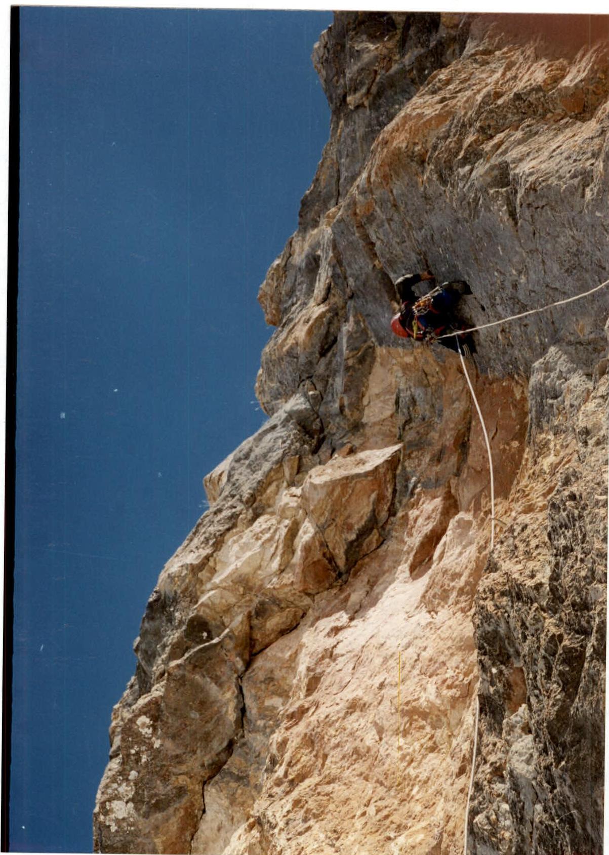
Photo 2. Section R0–R1. Start of the route. The photo was taken on February 23, 1998.