Ascent Passport
I. Class: Rock 2. Region: Eastern Caucasus 3. I-st Western Yarydag (4020 m) via the Western wall through the 2nd "well" and along the Southern ridge. 4. Difficulty category: 5B 5. Height difference: 1090 m, length of sections with 5-6 difficulty category - 270 m. Average steepness: wall - 75°, ridge - 45° 6. Pitons driven: rock - 51 For artificial climbing techniques - 4 Chocks - 16 Ice - (dash) Bolts - (dash) 7. Number of climbing hours - (dash) 8. Number of nights: one, water on the route, good bivouac site. 9. Andreev Vladimir Ivanovich, Candidate Master of Sports, team leader
- Polishchuk Vladimir Anatolyevich, Candidate Master of Sports
- Parshin Vladimir Semenovich, 1st sports category
- Trofimov Dmitry Alekseyevich, 1st sports category
- Departure to the route April 27, 1980 Return April 28, 1980
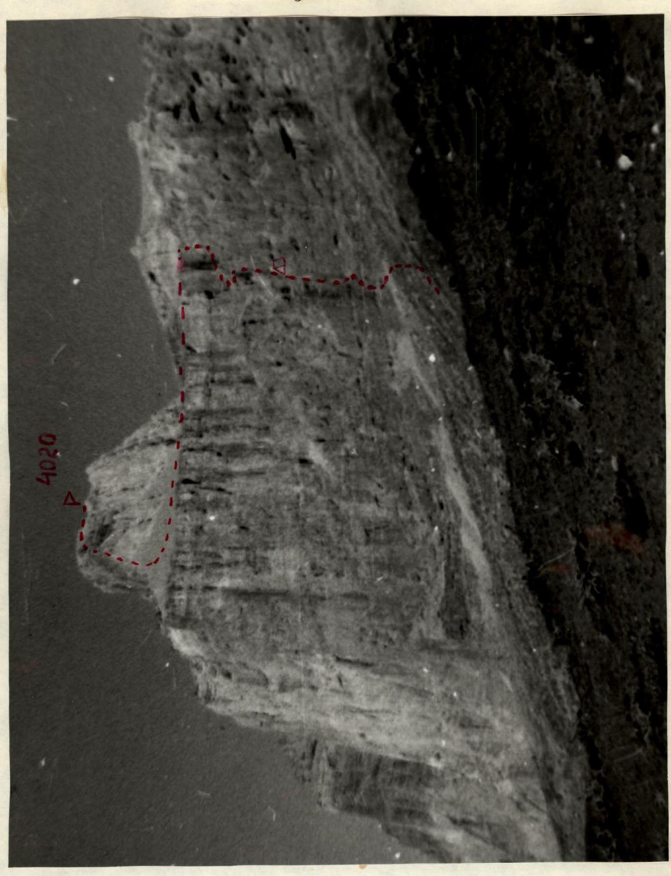
Ascent route to I-st Western Yarydag via the Western wall and Southern ridge through the 2nd "well".
The entrance to the "well" goes along stepped rocks straight up. The "well" is a large cirque. Along the talus covered with snow, we ascend under the inner wall of the "well". Here is a good place for a night's stay. From a wide shelf, the path goes to the right along a narrow long shelf towards a clearly visible frozen waterfall hanging like a giant icicle. The shelf leads to snow-covered and wet walls. Under the icicles along the shelf - into a deep canyon and along it - onto a wide talus plateau.
- The summit of I-st Western is to our left.
- The path to it along a snowy gentle slope leads us to the beginning of the southern ridge.
- The ascent begins along a talus couloir with snow.
- Along a smooth wall - to a sharp ridge crest.
- Along the ridge and large talus, we reach the summit.
The descent is from the cairn to the north, and then to the right, we descend to the plateau. From the plateau to the east - bypassing the rock step of the massif in the direction of the Kurush river.
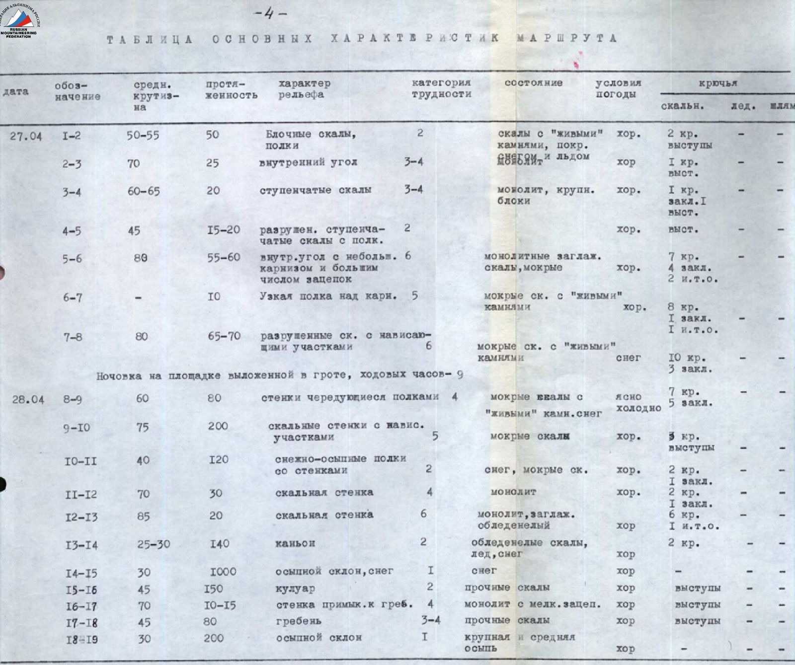
Table of main route characteristics
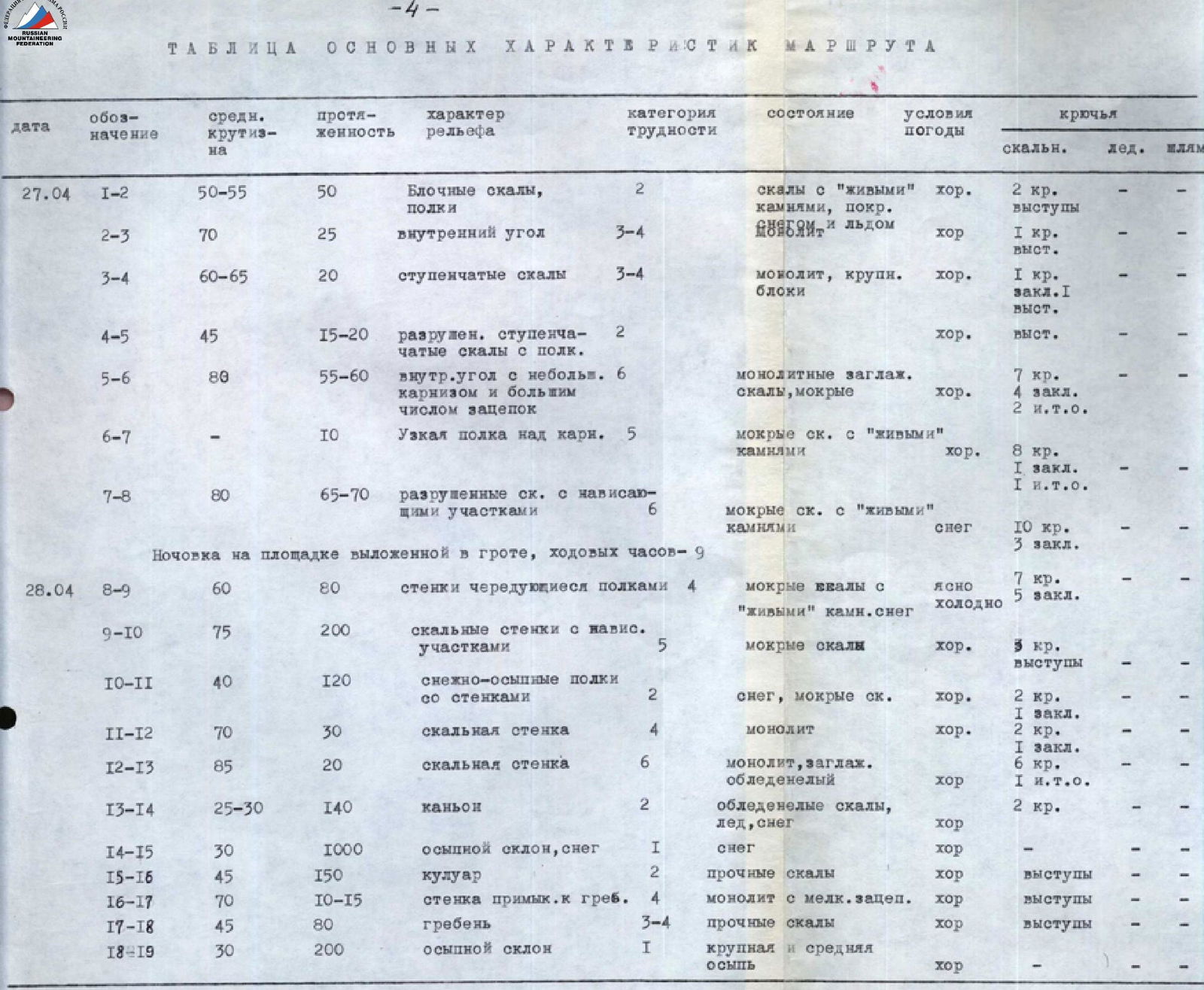
| Date | Designation | Average steepness | Length | Terrain characteristics | Difficulty category | Condition | Weather conditions | Pitons (rock/ice/bolts) |
|---|---|---|---|---|---|---|---|---|
| April 27 | R1–R2 | 50–55° | 50 m | Blocky rocks, shelves | 2 | Rocks with "live" stones, covered | Good | 2 pitons (outcrops) |
| R2–R3 | 70° | 25 m | Inner corner | 3–4 | (dash) | Good | 1 piton (outcrops) | |
| R3–R4 | 60–65° | 20 m | Stepped rocks | 3–4 | Monolith, large blocks | Good | 1 piton, 1 chock (outcrops) | |
| R4–R5 | 45° | 15–20 m | Destroyed stepped rocks with shelves | 2 | (dash) | Good | (outcrops) | |
| R5–R6 | 80° | 55–60 m | Inner corner with a small cornice and many holds | 6 | Monolithic, smoothed rocks, wet | Good | 7 pitons, 4 chocks, 2 artificial aids | |
| R6–R7 | (dash) | 10 m | Narrow shelf above the cornice | 5 | Wet rocks with "live" stones | Good | 8 pitons, 1 chock, 1 artificial aid | |
| R7–R8 | 80° | 65–70 m | Destroyed rocks with overhanging sections | 6 | Wet rocks with "live" stones | Snow | 10 pitons, 3 chocks | |
| Overnight stay on a platform laid out in a grotto. Climbing hours - 9 | ||||||||
| April 28 | R8–R9 | 60° | 80 m | Walls alternating with shelves | 4 | Wet rocks with "live" stones, snow | Clear, cold | 7 pitons, 5 chocks |
| R9–R10 | 75° | 200 m | Rock walls with overhanging sections | 5 | Wet rocks | Good | 3 pitons (outcrops) | |
| R10–R11 | 40° | 120 m | Snow-talus shelves with walls | 2 | Snow, wet rocks | Good | 2 pitons, 1 chock | |
| R11–R12 | 70° | 30 m | Rock wall | 4 | Monolith | Good | 2 pitons, 1 chock | |
| R12–R13 | 85° | 20 m | Rock wall | 6 | Monolith, smoothed, icy | Good | 6 pitons, 1 artificial aid | |
| R13–R14 | 25–30° | 140 m | Canyon | 2 | Icy rocks, ice, snow | Good | 2 pitons | |
| R14–R15 | 30° | 1000 m | Talus slope, snow | 1 | Snow | Good | (dash) | |
| R15–R16 | 45° | 150 m | Couloir | 2 | Strong rocks | Good | (outcrops) | |
| R16–R17 | 70° | 10–15 m | Wall adjacent to the ridge | 4 | Monolith with small holds | Good | (outcrops) | |
| R17–R18 | 45° | 80 m | Ridge | 3–4 | Strong rocks | Good | (outcrops) | |
| R18–R19 | 30° | 200 m | Talus slope | 1 | Large and medium talus | Good | (dash) |
Climbing hours - 8, return - 2 hours. 51 pitons, 16 chocks. Total climbing hours - 19.
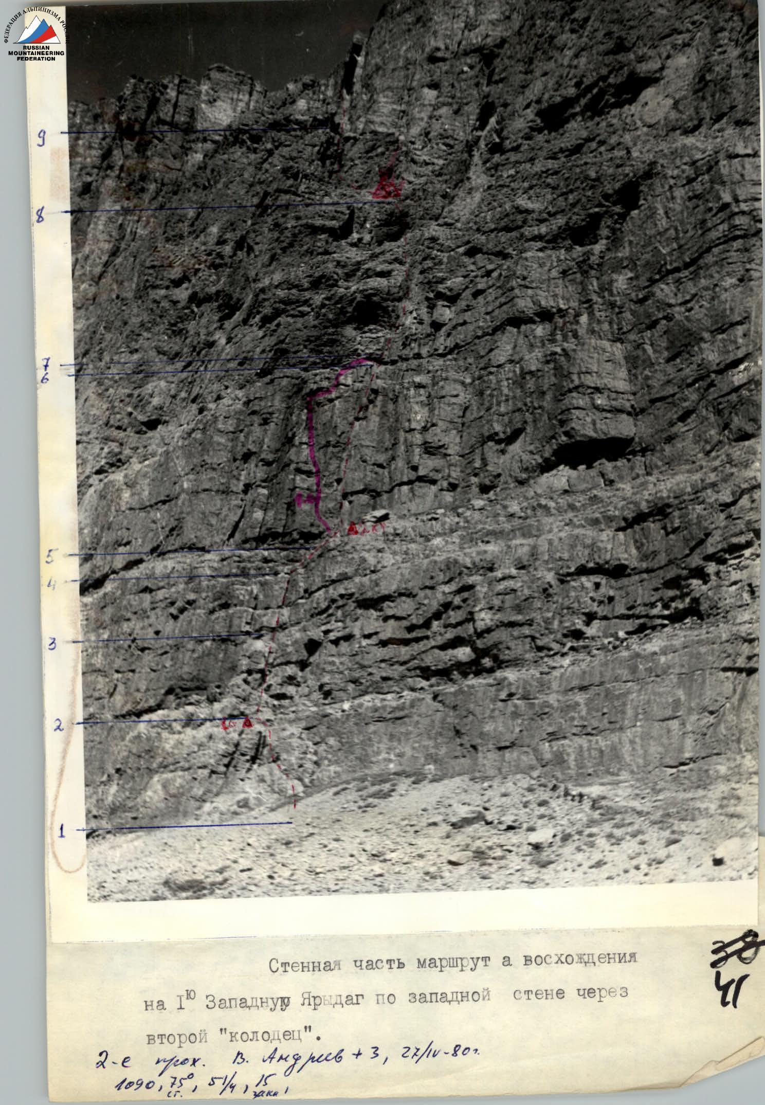
The wall section of the ascent route to I-st Western Yarydag via the Western wall through the second "well". 2nd ascent. V. Andreev +3. 27/11-80. 1090 m, 75°, 51 (pitons), 4 (artificial aids), 15 (chocks).
Explanations for the table of main route characteristics
The ascent route can be divided into two parts: wall and ridge. The wall height difference is 700 m, the height of the summit tower is 390 m.
April 27. We left the camp early, at 6:00, it was cold, but clear. The lower part of the wall is composed of monolithic metamorphosed limestones of red color, dissected by horizontal lines of fractures. Live stones on these rocks are found mainly only on shelves, there are few small cracks, and they are all filled with ice, the rock surface is smooth.
The route begins with a large talus approaching the wall. To the right of the black streak, the path goes to the left along simple rocks with shelves and ascends to the first belt of red rocks (section R1–R2). Here on the shelf is the 1st control cairn.
We bypass the "pillar" along narrow shelves from the outside, and behind it along the inner corner (section R2–R3), a cleft (R3–R4), and stepped rocks (R4–R5), we ascend to a shelf to the right of the cornices of the 2nd belt of red rocks. A good landmark is the waterfall to the left. Here is the 2nd control cairn. A good place for a night's stay.
From the shelf to the left, above the edge of the cornices, we move into a steep inner corner. Along the inner corner, we ascend under the upper cornice (R5–R6). Everything is covered with ice, with strong gusts of wind from the waterfall, droplets reach us. We have to use artificial aids.
After several steep walls (R8–R9) - exit to a niche (grotto). It started snowing. We had to stop for the night, laid out a platform in the grotto.
April 28. Directly from the overnight stay under the overhanging rocks, many live stones, along a cleft through a "belly" up to a shelf covered with snow.