Ascent Passport
-
Ascent class — rock climb
-
Ascent area according to KTMGV (Mountaineering and Trekking Classification of Mountain Routes)
Eastern Caucasus
-
Peak, its height, and ascent route
Dyultydag 4127 m via the northeast ridge
-
Proposed category of difficulty 2B cat. diff. ≈ 15 / 1–80
-
Route characteristics:
elevation gain 280 m, average steepness 45°, length of sections I — 150 m; II — 8 m; III — 180 m; IV — 50 m; V — 150 m; VI — 5 m; VII — 20 m.
-
Number of protection points drilled:
rock anchors — 10, ice anchors — , bolt anchors —
-
Number of climbing hours 4–5 hours.
-
Number of nights and their characteristics — none.
-
Surname, name, patronymic of the leader and participants, their sports qualification:
Sayapin Anatoly Konstantinovich — Candidate for Master of Sports Shabrukov Viktor Ivanovich — 1st sports category Gorin Vladimir Vasilievich — 2nd sports category Amirkhanov Abdusalam Magomedovich — 2nd sports category
-
Team coach — Sayapin Anatoly Konstantinovich — Candidate for Master of Sports.
-
Date of departure and return — February 7, 1979
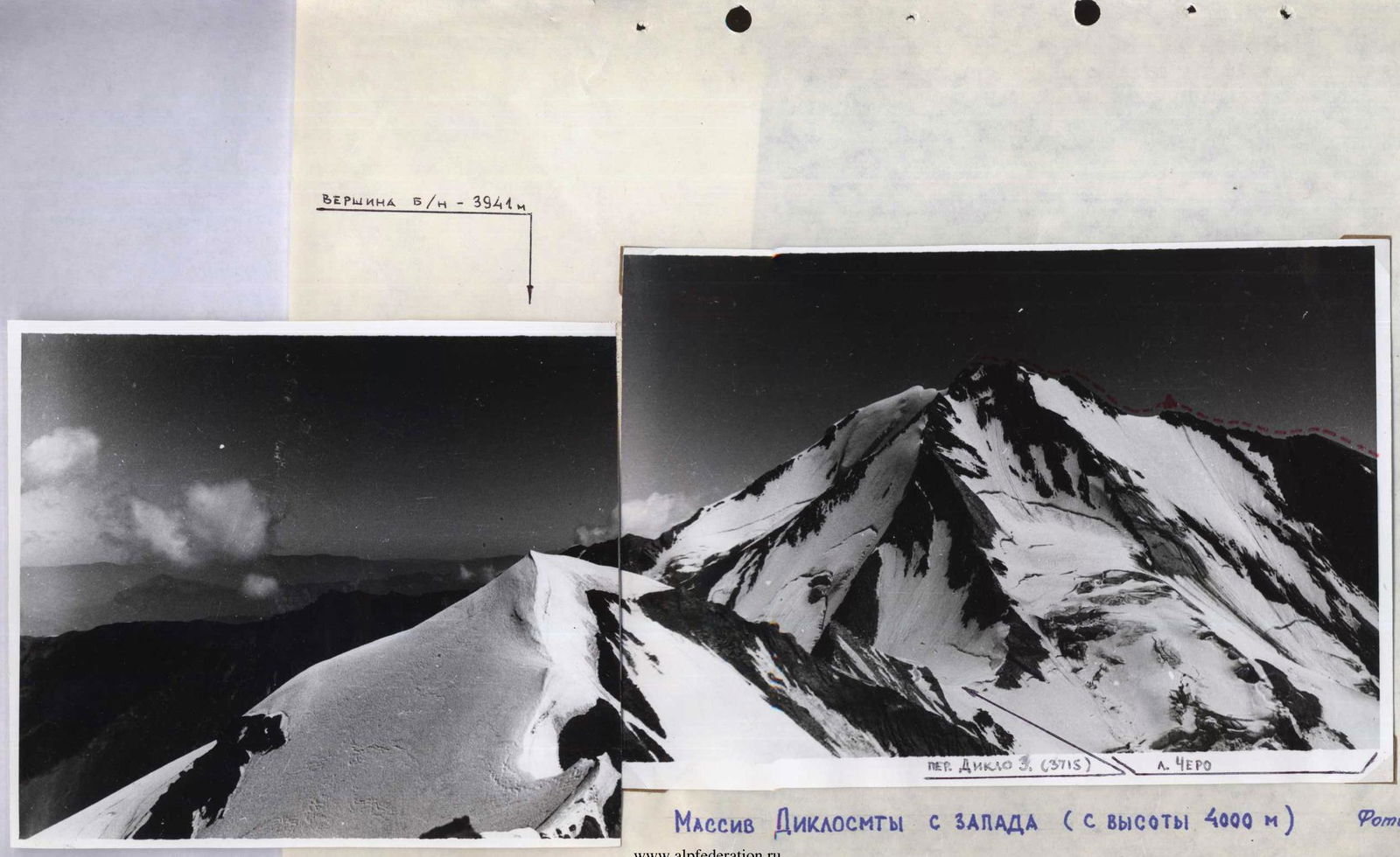
Diklosm massif from the west (from a height of 4000 m) Photo No. 9

ROUTE MAP TO THE SUMMIT OF DYULTYDAG (Via the northeast ridge)

LEGEND:
— Base camp
— summit
---..- ascent route of the climbing group
--- Descent route of the climbing group

Section characteristics of the route
To the summit of Dyultydag via the northeast ridge. Approximately 2B cat. diff.
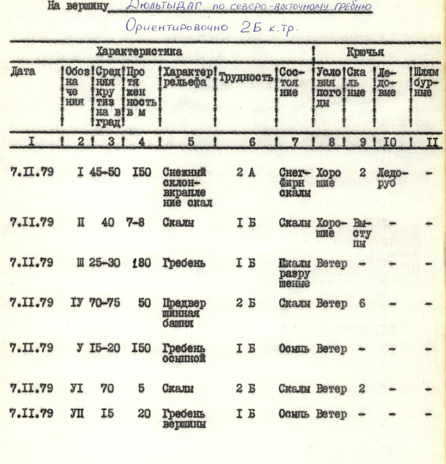
| Date | Section | Average steepness, degrees | Length in m | Terrain characteristics | Difficulty | Condition | Weather conditions | Rock anchors | Ice anchors | Bolt anchors |
|---|---|---|---|---|---|---|---|---|---|---|
| November 7, 1979 | I | 45–50° | 150 m | Snow slope with rock outcrops | 2A | Snow-firn, rocks | Good | 2 | 2 ice axes | - |
| November 7, 1979 | II | 40° | 7–8 m | Rocks | 1B | Rocks | Good ledges | - | - | - |
| November 7, 1979 | III | 25–30° | 180 m | Ridge | 1B | Rocks, broken | Wind | - | - | - |
| November 7, 1979 | IV | 70–75° | 50 m | Pre-summit tower | 2B | Rocks | Wind | 6 | - | - |
| November 7, 1979 | V | 15–20° | 150 m | Ridge with scree | 1B | Scree | Wind | - | - | - |
| November 7, 1979 | VI | 70° | 5 m | Rocks | 2B | Rocks | Wind | 2 | - | - |
| November 7, 1979 | VII | 15° | 20 m | Summit ridge | 1B | Scree | Wind | - | - | - |
Description
of the approach to the route to the summit of Dyultydag via the northeast ridge. Approximately 25 km on foot.
From Burshinsky bridge along the trail on the left bank of Kazikumukhskoye Koisu to the confluence of the Kukkur and Kazikumukhskoye Koisu rivers (4 hours).
100 m before the bridge over the Kukkur river — a convenient place for a base camp. Then from the bridge along the left bank of the Kukkur river to the confluence of the Bodonay river (3 hours).
From here, we cross the Bodonay river and move in the direction of the Dyultydag peak along a vaguely defined ridge to the southeast ridge of the peak (2.5–3 hours).
We cross the cirque in the direction of the ascent of the I-st rock belt of the northeast ridge and approach the route (30 minutes). From Burshinsky bridge to the start of the route — 9–10 hours.
Description
of the ascent route to the summit of Dyultydag via the northeast ridge. Approximately 25 km on foot.
The route begins with an ascent up a steep snowy slope in the direction of the rocks of the I-st rock belt, leading to the northeast ridge. After passing 7–8 m of simple rocks, we move along the broken ridge in the direction of the pre-summit tower. We overcome the tower "head-on", sticking to the right side of the rocks (Careful belay! Anchors!).
On the tower — a control cairn.
After the control cairn, we move along a simple scree ridge leading to a small pre-summit rock ascent, in the direction of the summit (Belay! Anchors!). After the ascent — along a simple broken ridge to the summit.
Descent via the ascent route.
- From the start of the route to the control cairn — 4 hours.
- From the control cairn to the summit — 1 hour.