
Climbing Passport
I. Route Type: COMBINED
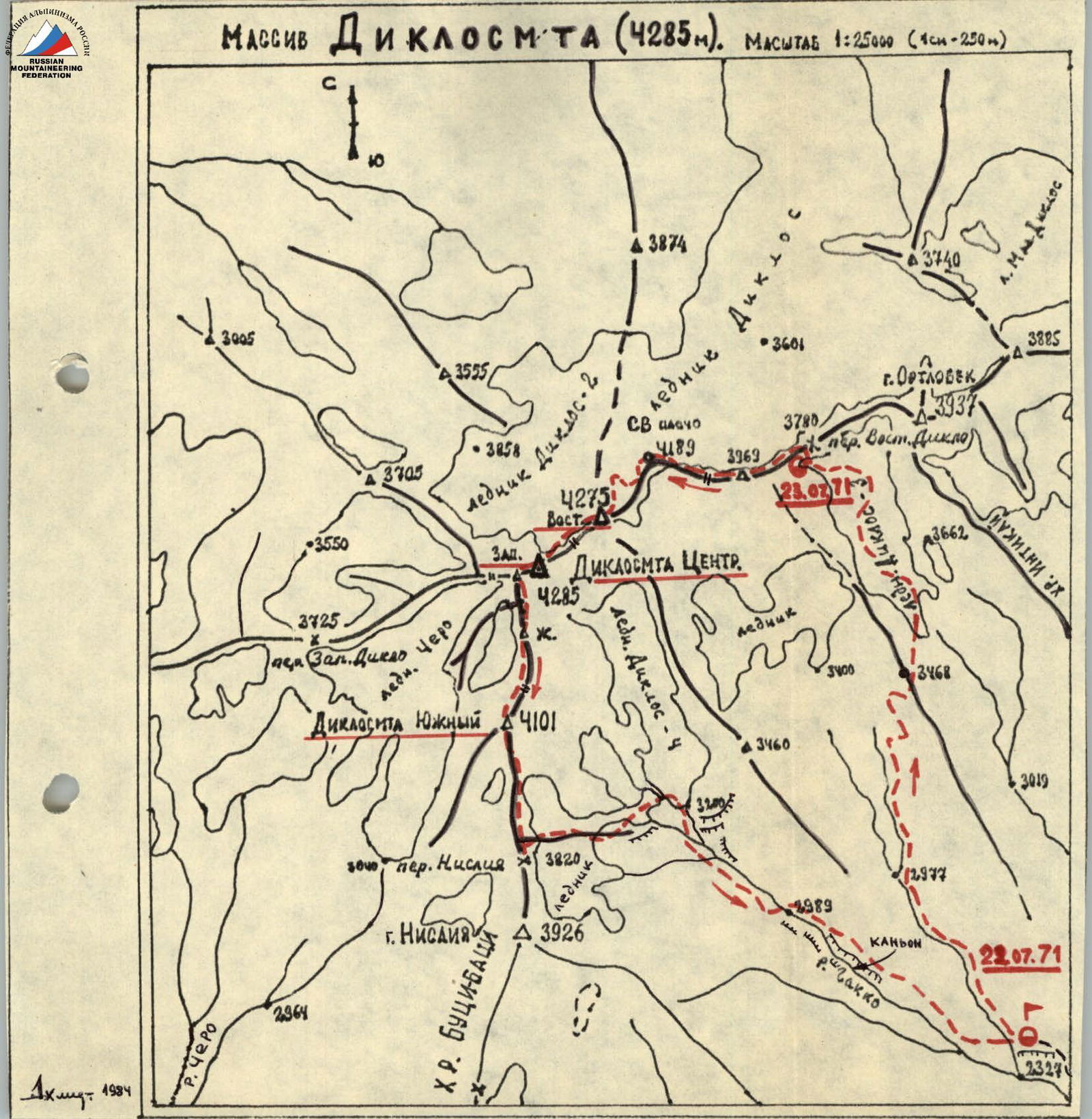
- Eastern Caucasus (Dagestan mountains)
- Traverse of the DIKLOSMTA massif (4275 m, 4285 m, 4240 m, 4101 m) from East to South
- Proposed difficulty category — 3B
- Route characteristics:
- total distance — 3200 m
- total elevation gain — 1740 m
- average steepness — traverse
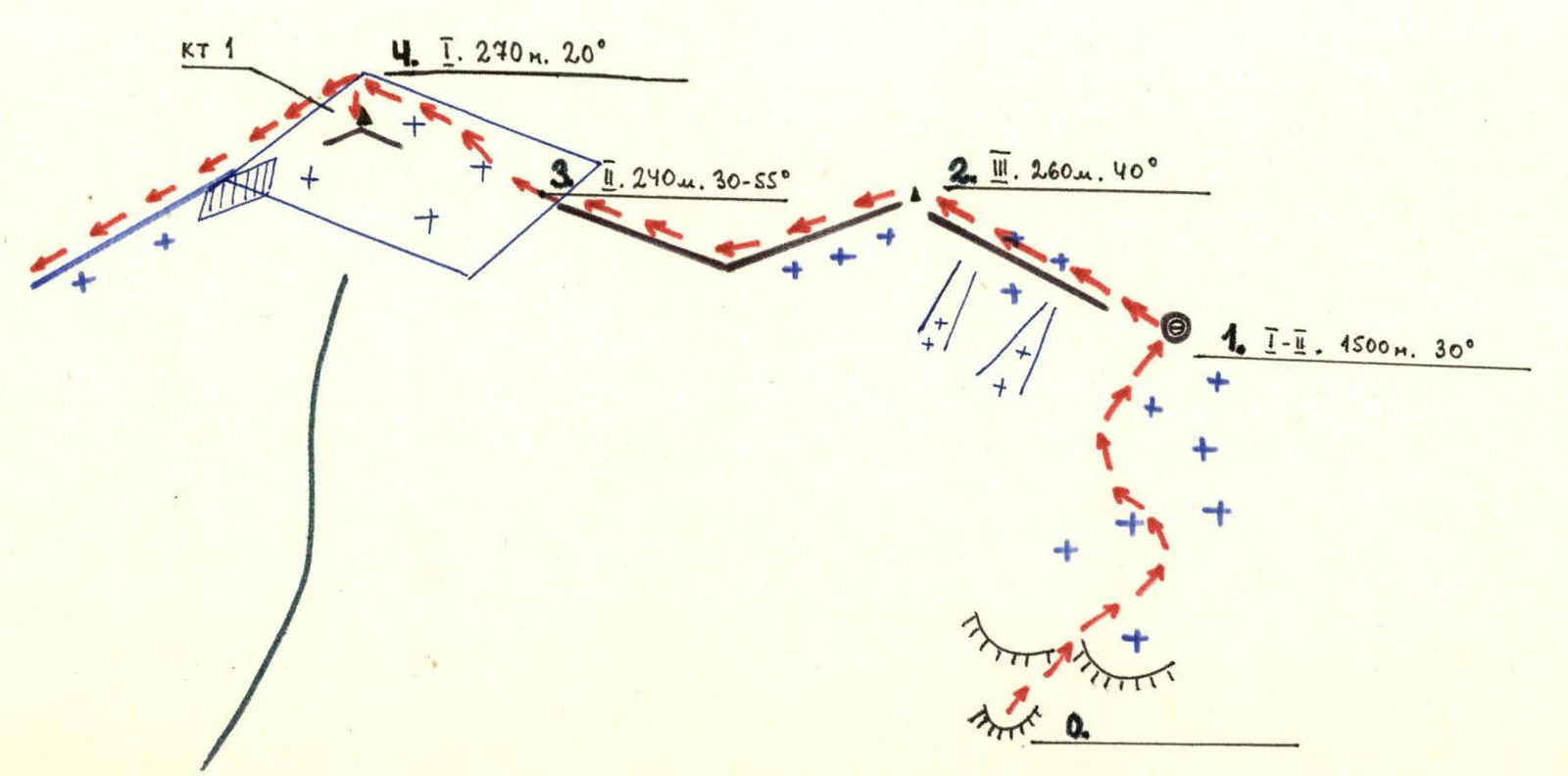
- section lengths: R1 — 1770 m R2 — 290 m R3 — 1030 m R4 — 110 m R5 — 50 m
- Pitons driven:
- for belaying:
- rock — 8
- ice — 3
- bolted —
- for creating I.T.O. — 1
- for belaying:
- Overnight stay on the Diklo East col. Platform.
- 2 hours 10 minutes
- Participants:
- Akhmedkhanov K.E. — 2nd sports category
- Pashchuk E.G. — 2nd sports category
- Osmanov M.G. — 3rd sports category
- Abdullaev T.G. — 3rd sports category
- Zelensky A.U. — 3rd sports category
- Kekalo P.D. — 3rd sports category
- Coach — Master of Sports of the USSR Timoshin M.E.
- Date of departure on the route — July 22, 1971, date of return — July 23, 1971
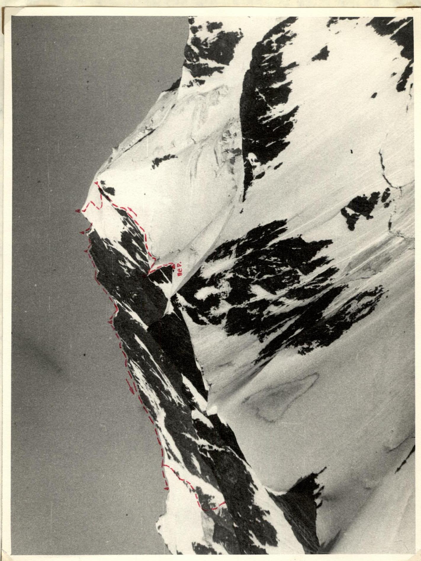
 Diklosmta (23.) with the saddle between E. and W.
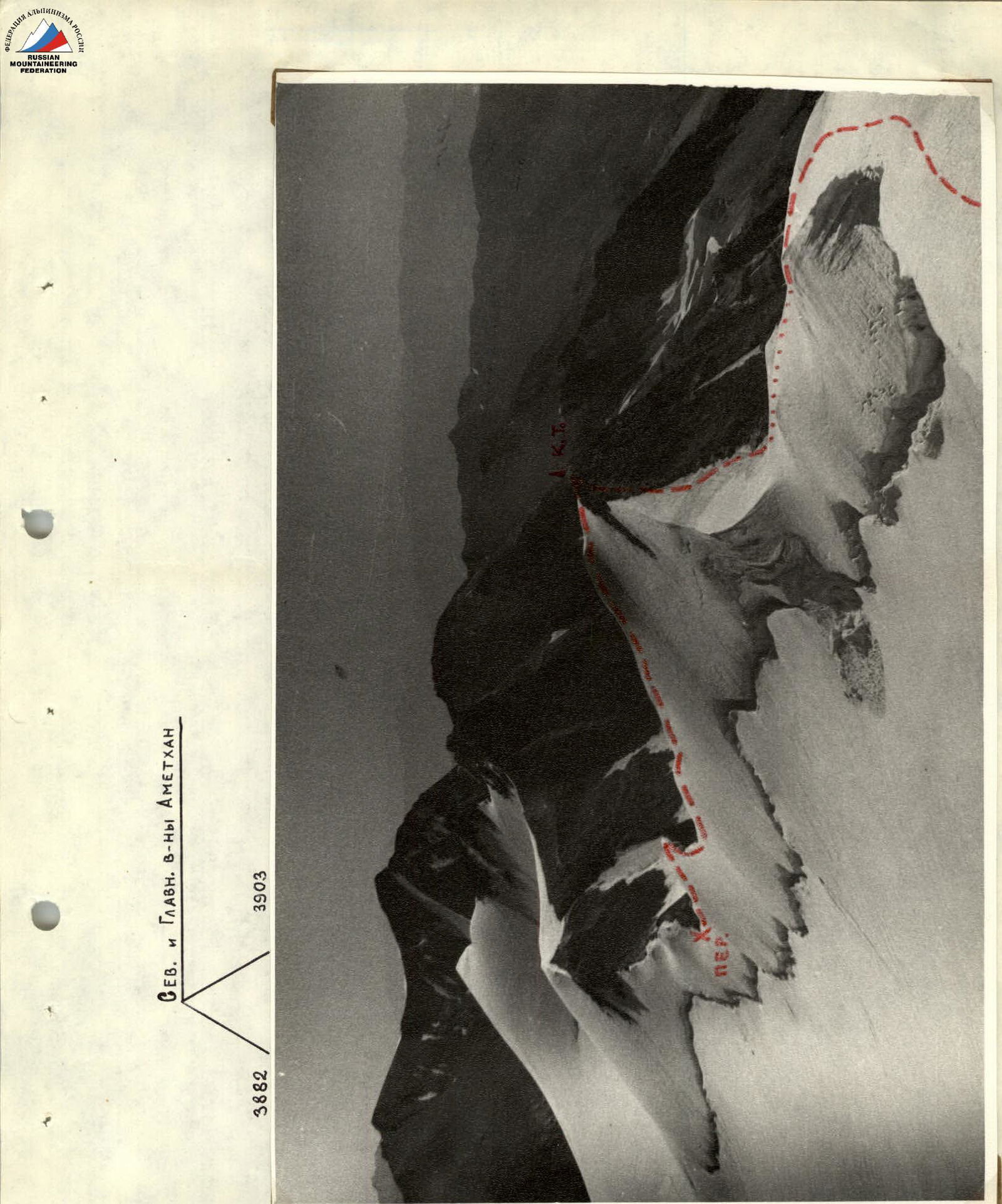
GENERAL VIEW OF THE DIKLOSMTA MASSIF. View from the east (from a height of 3903 m) photo №1

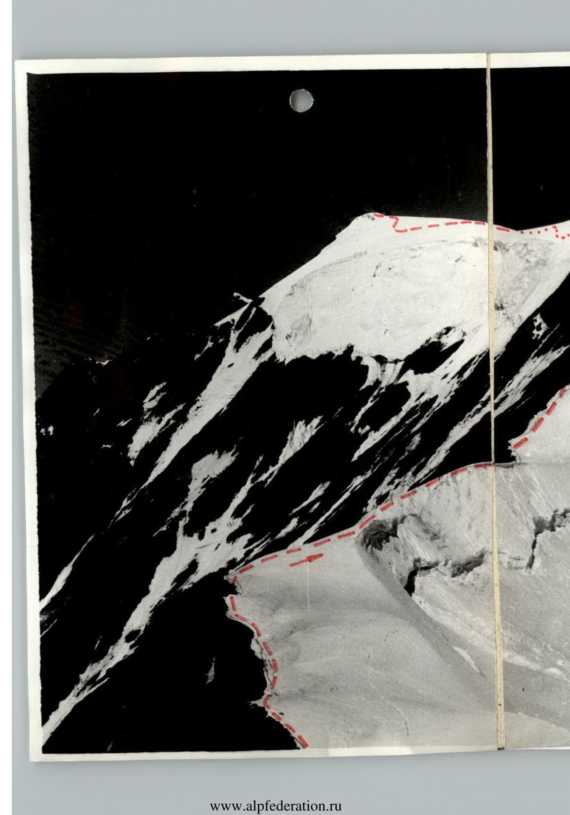
INITIAL SECTION OF THE TRAVERSE. Diklo East col (3780 m), unnamed peak 3969 m. The extreme right is the Ortloek saddle. Photo №2

BUCI-BACI RIDGE. From right to left: Central, West, and South peaks of Diklos. Photo №6
Brief characteristics of the massif
The Diklosmta massif consists of two main peaks — East (4275 m) and Central (Main) (4285 m) and two secondary peaks — West (4240 m) and South (4101 m). The first three peaks are located on the ridge of the Snowy Ridge, and the South peak is on the ridge of the Buci-Baci ridge, which connects to the Snowy Ridge at the Diklos West peak.
The nearest neighboring peaks are: to the west — G. Gala-vanas-cveri (also known as S. Japaridze peak) (4086 m), to the south — G. Nisliya (3926 m) and to the east — G. Ortloek (3937 m). The geological structure of the massif is homogeneous — black metamorphic schists and sandstones. On all sides, Diklosmta is surrounded by powerful glaciation.
Two routes have been laid to the peaks of the Diklosmta massif. To Diklosmta Central — a combined route from SE, 2B, and to Diklosmta East — a rock route along the East ridge, 1B category of difficulty. The MK Federation of Alpinism of Dagestan has no information about ascents to neighboring peaks.
Note: — the prefix "mta" from Georgian means "mountain". We consider it possible to omit this prefix if the word "mountain" or "peak" precedes the word Diklo.
Approach to the route
From the village of Agvali — the district center of the TsUMADINSKY district of the DASSR by a gravel road and then by trail to the village of Gakko. From it, along the left bank of the Gakko river to the confluence of the two sources of this river. On the bank of the left source — the base camp (2340 m). From a. Gakko 3 hours.
Along the grassy slopes at first and then rocky slopes, moving strictly north, in the direction of the Diklos-3 cirque glacier. Before the "sheep's rocks," descend from the slope to the stream.
Route description
Along the scree and simple rocks such as "sheep's foreheads" to the glacier. In rope teams across the closed glacier to the visible saddle of the V. Diklo col. Not reaching the pass 40–50 m (under the bergschrund) via broken rocks, exit to the ridge of the Snowy Ridge to the left (in the direction of travel) of the pass. Overnight stay (3780 m).
From the pass along rocks of medium difficulty to two consecutive ice couloirs (falling to the south, pitons!). To the "3969" peak along the snowy ridge of the edge of the Diklos glacier. Cairn. From the pass 50 minutes. Descent to the saddle along the rocks on the south side of the ridge. From the saddle to the peak of Diklos East, the route is described in the report "Diklosmta along the E ridge, 1B category of difficulty." Cairn on the peak of Diklos E. 20 m below its ice dome.
To Diklosmta Central along a narrow snow-ice ridge with cornices to the south. Descent to the saddle north of the ridge (cornices!). Behind the saddle, the character of the ridge remains the same until a sharp turn of the ridge to the northwest. The snow-rock ridge before the tower of Diklos Central is traversed simultaneously. Up a 12-meter two-tier wall (stones!) to the peak (from Diklos East — 1 hour 10 minutes).
Descent along a steep rocky rib with small walls, along shelves to a narrow gorge of the saddle (pitons). Above the saddle, to the right of the direction of travel, a narrow shelf. Further along the steep ridge (rockfall) to the foot of a destroyed wall along the wall (7 m) (pitons) to the peak of Diklos West. Cairn. From Diklosmta Central — 50 minutes (from the pass 4 hours). Traverse to the south from the peak by rappel (13 m). Through rocky spires to the "Double" gendarme. Bypassing is impossible. Through the peak of the gendarme (ascent along a steep ridge, descent by rappel) to the saddle. Along two rises of the ridge to the peak of the "Brick" gendarme. The peak is flat. Cairn. On the section Diklosmta West — "Brick" gendarme, called the "Diklos Saw", piton protection! (40 m).
From the "Brick" tower, initially along an 8-meter wall, and then along a rocky ridge of medium complexity (ice piton in destroyed rock!) to the saddle in the ridge. Ascent to the peak of the gendarme is traversed simultaneously. Along a narrow steep ridge (pitons!) to the saddle (cornice to the east!). A 65-meter destroyed ridge with a 7 m wall near the peak of Diklos South (protection!) leads to the highest point of the last peak of the massif. Cairn. From "Brick" 40 minutes).
Descent along a rocky ridge to the Nisliya pass (cornices to the east!). Along the eastern counterfort to the Diklos-4 glacier (possible ice on the rocks). Across the glacier to the source of the Gakko river and further along the canyon to the base camp. From Diklosmta South 1 hour 30 minutes.
Route sections table
| Date | Label | Average steepness in degrees | Length, m | Terrain type | Difficulty | Condition | Weather conditions | Rock pitons | Ice pitons | Outcrops |
|---|---|---|---|---|---|---|---|---|---|---|
| 07.71 | R0–R1 | 30 | 1500 | Grass, scree, glacier | 1 | "Sheep's foreheads", closed glacier | – | – | ||
| R1–R2 | 40 | 260 | Rocky ridge | 3 | Snow-covered, destroyed, ice formation | 1 | – | – | ||
| 23.07.71 | R2–R3 (descent) | 30 | 150 | – | 2 | Destroyed, ice formation | Sunny, slight cloudiness, strong wind | – | – | – |
| R2–R3 (ascent) | 55 | 90 | – | 3 | Destroyed with separate blocks | – | – | 10 | ||
| R3–R4 | 20 | 270 | Plateau and slope | 1 | Ice-snow | – | – | – | ||
| R4–R5 (descent) | 30 | 150 | Ridge | 3 | Snow-ice with cornices | – | – | – | ||
| R4–R5 (ascent) | 40 | 120 | Ridge, wall | 3 | Same, rocky destroyed | – | 1 | – | ||
| R5–R6 (descent) | 45 | 50 | – | 10–12 | Destroyed, walls, shelves | – | – | 2 | ||
| R5–R6 (ascent) | 45 | 50 | – | 3–4 | Same | 1 | – | – | ||
| R6–R7 | 55 | 100 | Ridge, walls, shelves | 10–12 | Sharp rocky with gendarmes and spires, "walls" | 3 | 1 | – | ||
| R7–R8 (descent) | 40 | 220 | Ridge, wall | 10–12 | Rocky with couloir and cornice | 1 | – | 8 | ||
| R7–R8 (ascent) | 45° | 80 | Ridge, wall | 8–11 | Rocky, firm, cornice | 1 | – | – |
Route scheme in UIAA symbols
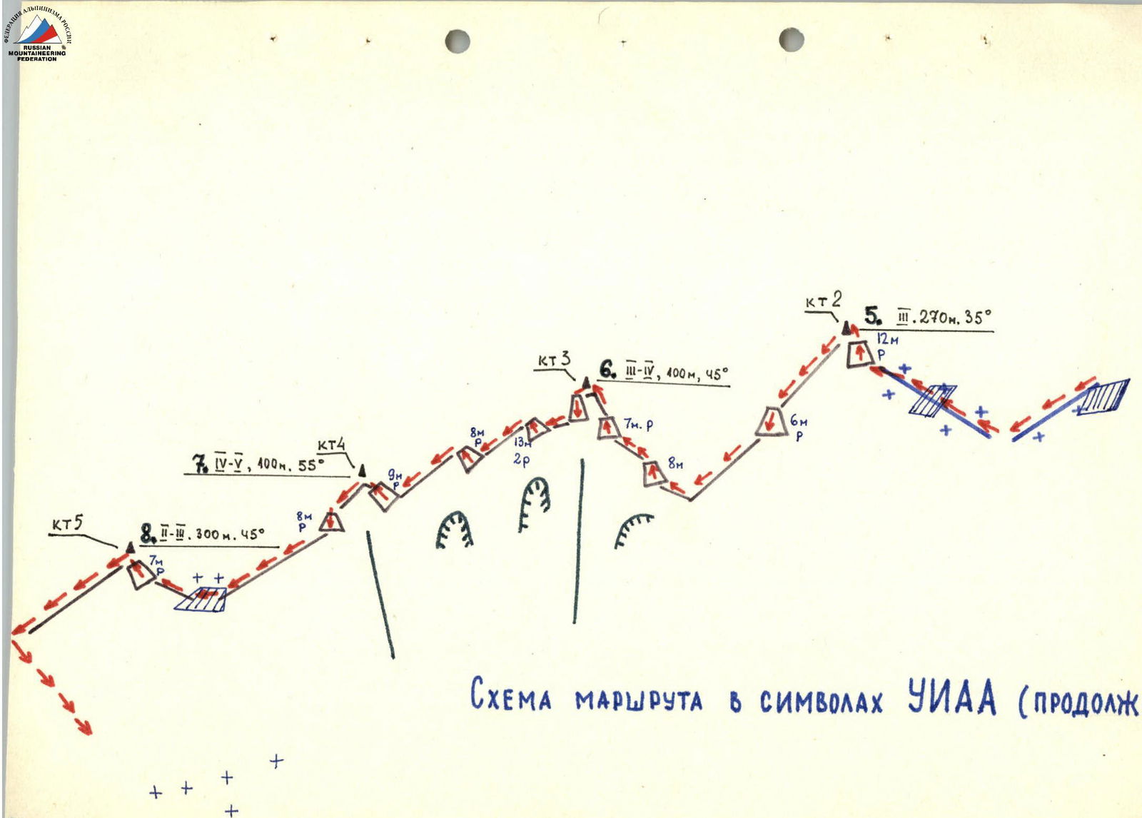
Route scheme in UIAA symbols (continued)
Section of the traverse, named by us "Diklos Saw"

Diklosmta — a key massif at the junction of Dagestan, Georgia, and Chechnya.
Comments
Sign in to leave a comment