
Ascent Passport
- Climbing type: rock climbing
- Climbing area: No. 2.9 (Eastern Caucasus)
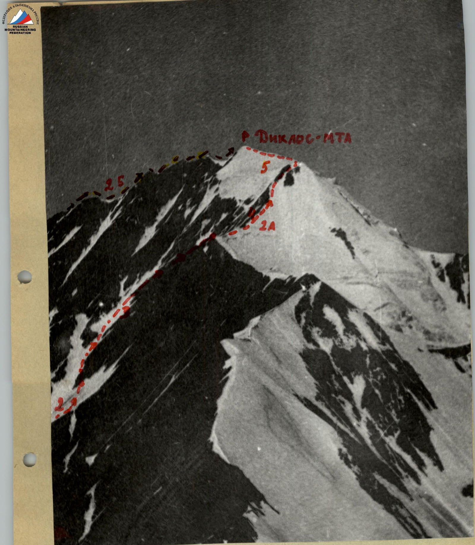
- Peak, its height, and ascent route: Diklos-mta 4285 m, via the eastern ridge
- Proposed difficulty category: approximately 2A category
- Route characteristics: elevation gain 600 m average slope 30° duration of sections R1–300 m, R2–850 m, R3–150 m for belaying, for creating, etc.
- Number of pitons driven: rock pitons – ice pitons – bolt pitons –
- Number of overnight stays and their characteristics: no overnight stays
- Number of climbing hours: 9–10
- Surname, name, patronymic of the leader and participants, their sports qualification:
- Kozorezov Evgeny Fedorovich – 1st sports category
- Leonov Petr Georgievich – 1st sports category
- Pashuk Evgeny Grigorievich – 1st sports category
- Kudryavtsev Anatoly Ivanovich – 1st sports category
- Team coach: MS Timoshin Mikhail Egorovich
- Date of departure and return: August 19, 1978
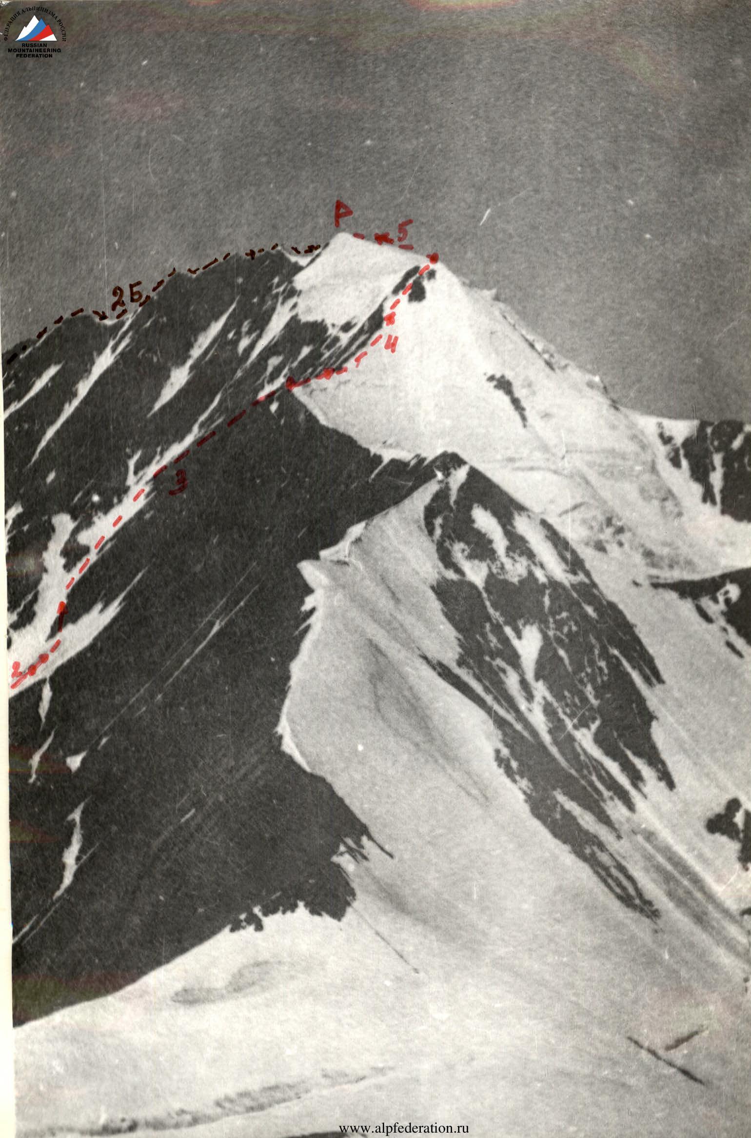
P — summit
– – ascent path
– – – 2B category route
View of the summit from the east
View of the summit from the south
Table
sections of the route to the summit of Diklos-mta (4285 m) via the eastern ridge, approximately 2A category
| Designation | Average slope in degrees | Length in meters | Terrain characteristics | Difficulty | Condition | Weather conditions | Rock Pitons | Ice Pitons | Bolt Pitons |
|---|---|---|---|---|---|---|---|---|---|
| R1 | 20 | 300 | dead glacier | 1 | wet snow, absence of crevasses | excellent | – | – | – |
| R2 | 40 | 200 | rantkluft, rocks, snowy couloir, scree | 2 | open rantkluft 8 m wide, easy broken rocks | – | belaying through outcrops | – | – |
| R3 | 40 | 350 | snowy couloir, scree slope | 2 | loose snow, rocks of smooth sandstone, medium scree | – | – | – | – |
| R4 | 60 | 150 | steep ascent of shale ridge | 3 | heavily broken shale rocks, many ledges and grips | – | belaying through large outcrops | – | – |
| R5 | 10 | 300 | ice dome | 2 | hidden glacier with a wide crevasse near the summit | – | – | belaying with an ice axe | – |
Description of the approach to the route.
From the district center Agvali by car to the village Echeda, then along the lower trail to the village Gakko (1 day), from there along the trail to the base camp (3–4 hours). From the base camp, located at the confluence of the Diklos and Nisliya rivers, go up along the shepherd's trail into the Diklos-mta cirque. The trail traverses a steep grassy slope and disappears on the scree. Go steeply up the scree, then turn left and exit to the koshu along the grassy slope. From it, ascend along the right snowy slope to the conical glacier. (From the base camp — 4 hours.)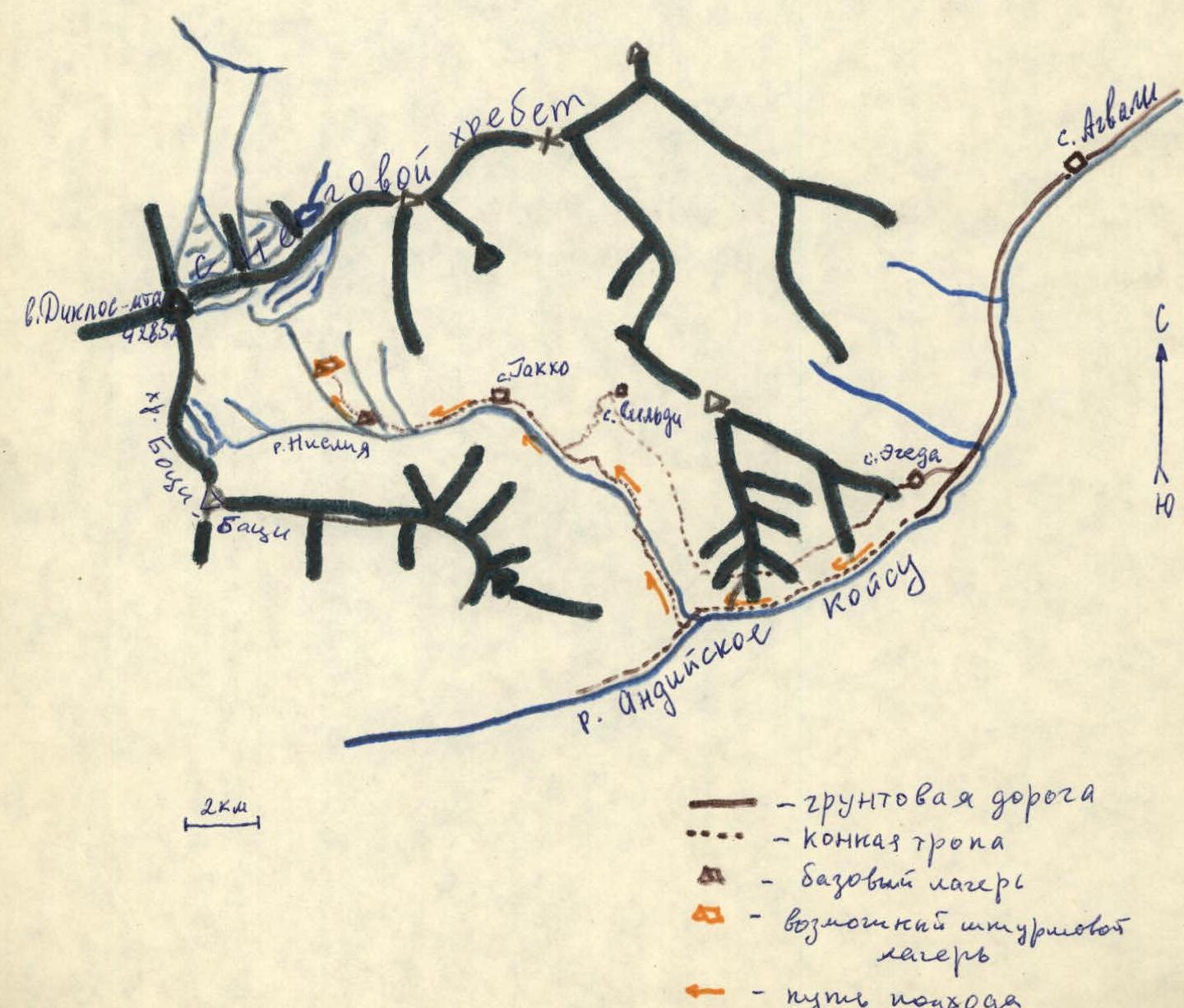
Route description.
- Approach the rantkluft along the glacier and cross it with belaying to easy rocks (10 m), then exit to a gentle scree ledge.
- Cross it and move 50 m up and to the right along the snowy couloir, overhung by a hanging glacier.
- Ascend 60 m along inclined slabs covered with rubble.
- Ascend along the snowy slope to the rocks (belaying!).
- Turn left along the rocks and in a serpentine manner exit to the saddle of the snowy ridge along the scree (3 hours from the glacier).
- Then, along the steep shale ascent of the ridge, belaying through bends and outcrops, exit to the eastern shoulder of Diklos-mta (40 min. – 1 hour from the saddle).
- Cross the ice dome and, organizing belaying through an ice axe near the crevasse, exit to the summit (from the shoulder – 30–40 min.).
Tur — on the rocky outcrop to the left and 20 m below the summit ridge. Descent via the ascent path.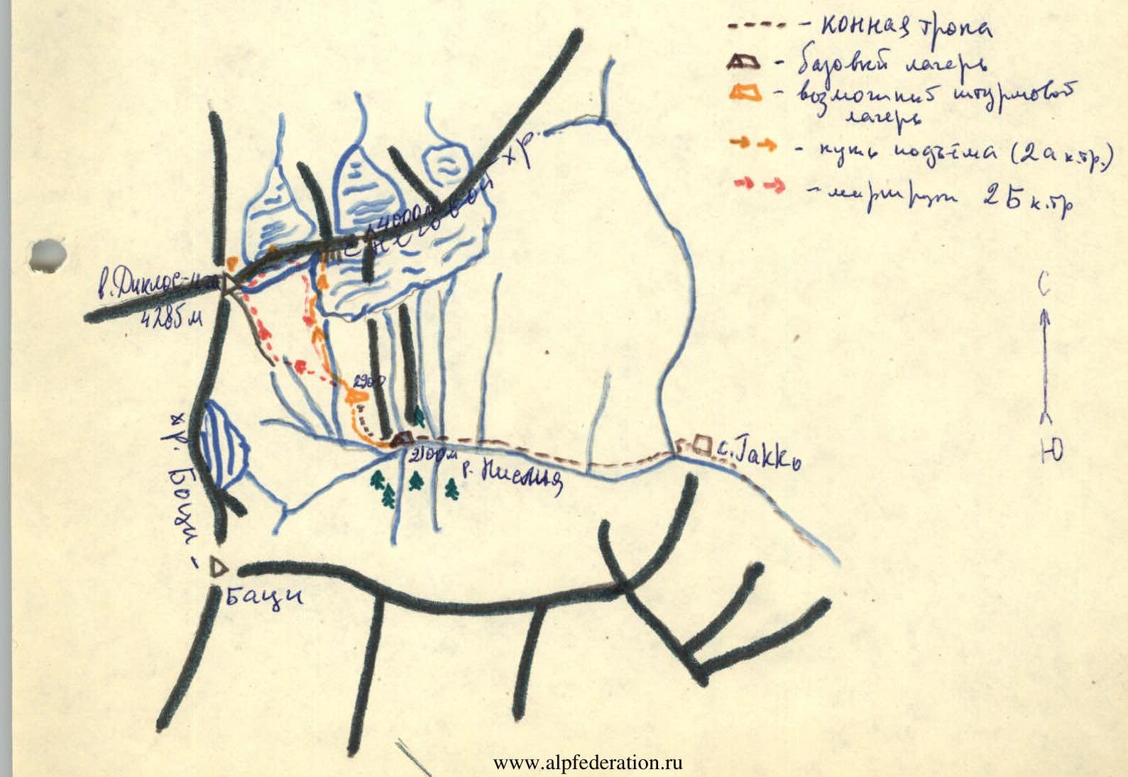
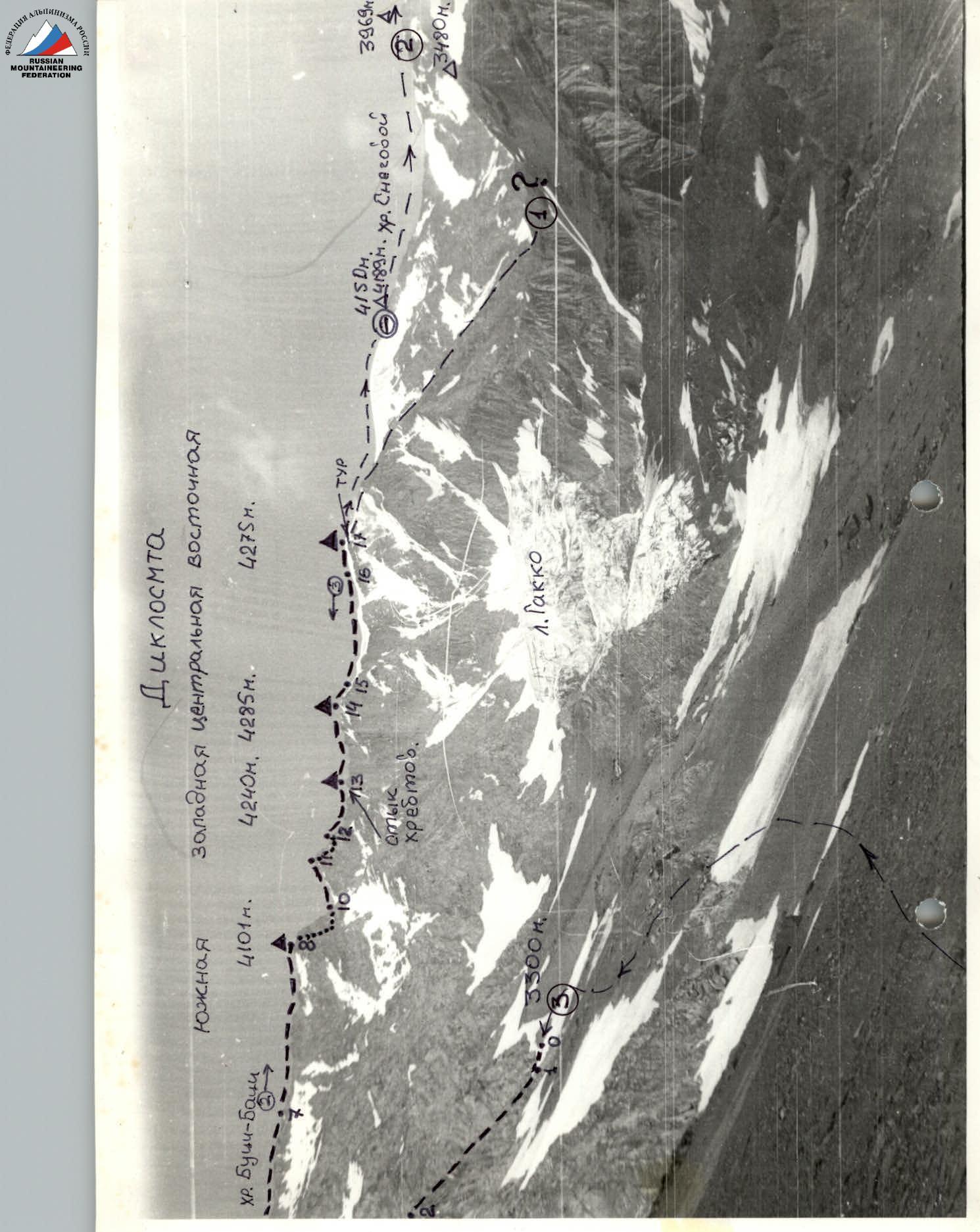
Photo — General view of the summit of Diklos-mta from the south.
- Route to Diklos-mta Central via the South ridge, 2B category. A. Gadzhiev, 1957.
- Route to Diklos-mta East via the East ridge, 2A category. E. Kozorezov, 1978.
- Traverse route Diklos-mta East–South. K. Akhmedkhanov, 1971.
- First ascent of the traverse Diklos-mta South–East, 3B category, combined, K.Doppo — 1992.
Photo from August 5, 1992, point "O"
Comments
Sign in to leave a comment