Ascent Passport.
- First ascent category.
- Region 2.10., Caucasus, Dagestan mountains, Shalib ridge.
- Bodonai 4049 m, via the Northeast wall, combined route.
- 4A category of difficulty, first ascent.
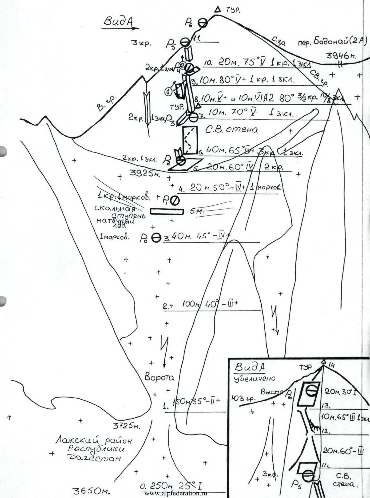
- Route characteristics: height difference 400 m, average steepness 50 °, length 730 m, by sections: 1 – 270 m, 2 – 150 m, 3 – 130 m, 4 – 120 m, 5 – 50 m, 6 – 10 m, of which climbing with aid: A2 – 10 m.
- Used: 21/8 chocks, 18/2 rock pitons, 3 "carrot" ice screws, 1 rock protrusion; 3 rock pitons left on the route (at points 6, 8 (control cairn), 10).
- Climbing hours: 5 hours.
- Overnight at the moraine pocket (3500 m) in the NE cirque, in the upper reaches of the Bodonai river.
- Dorro Konstantin Eduardovich — Candidate Master of Sports Voronin Sergey Valerievich — 1st sports category
- Departure, summit, return — July 6, 1995.
- Organization: Mountain club "EOS".
- Bodonai
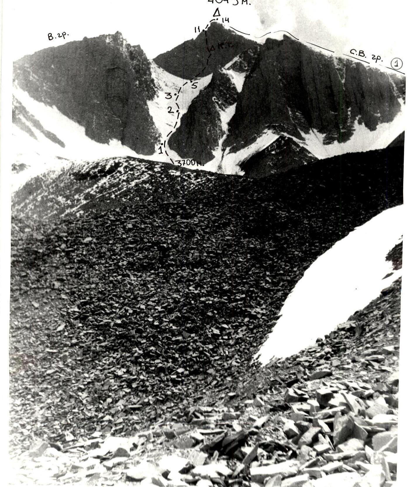
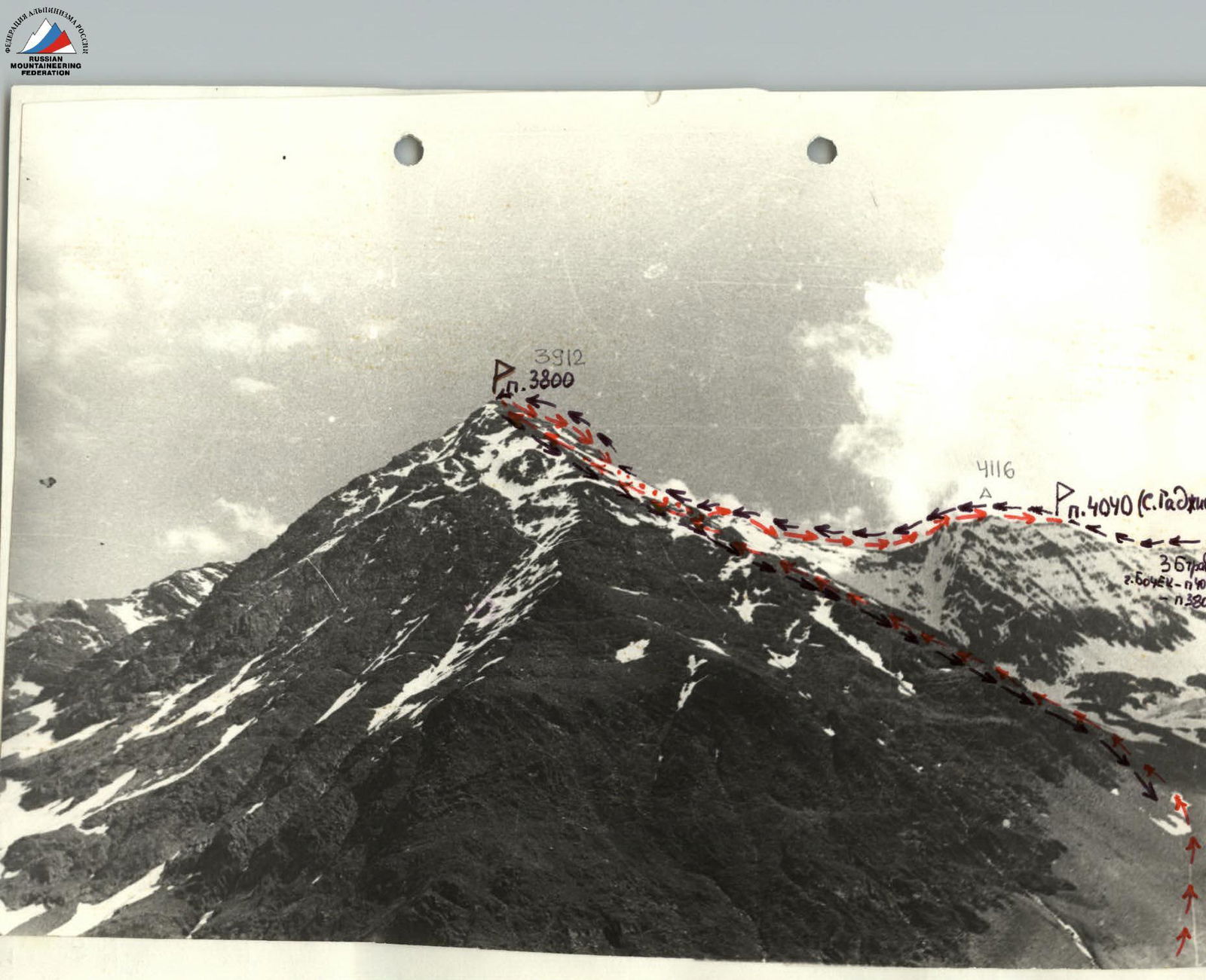
Photo: general view of Bodonai peak (4049 m) and the ascent route via the NE wall. Taken on July 4, 1995, 16:00. (1) Route via the NE ridge by E. Kozorezov – 78 (ridge NNE exposure).
Approach Description
From Khulisma village (1900 m), Laksky district, Republic of Dagestan, southward along a dirt road to the confluence of the Burshi and Kazikumukhskoe Koisu rivers (2080 m) — 2.5 hours. Just below the confluence is the "Burshinsky" bridge. From it, along a trail on either bank of the Kazikumukhskoe Koisu river (in winter, the trail is partially iced, crampons needed!).
After the major left tributary, Charinekh river (2150 m):
- the trail follows the floodplain for about 1.5 km,
- then climbs up the slope and then along a terrace,
- crosses three small left tributaries,
- leads to the confluence of the Nukkur river with Koisu on the left (2457 m, 4 hours), with a bridge at the confluence.
Further up the Nukkur river to a summer pasture at the confluence of the Bodonai river on the left (2700 m, 2 hours). Cross the Bodonai river and, along the right bank, on a trail with significant elevation gain, reach a high promontory, bypassing rocky outcrops and traversing a conglomerate slope into the hanging glacial valley of Bodonai, and along it northwestward toward the gradually opening NE wall of Mt. Bodonai.
Overnight can be conveniently done at a moraine pocket at 3500 m (6 hours) at the end of a characteristic gully. Then — to the moraine ridge bend and leftward eastward, along large-block talus and firn — to the beginning of the left couloir of the NE wall (3650 m, 1 hour). Start of the route.
In good weather, during summer, and in good physical condition, the approach to the route from Khulisma village is possible in a day.
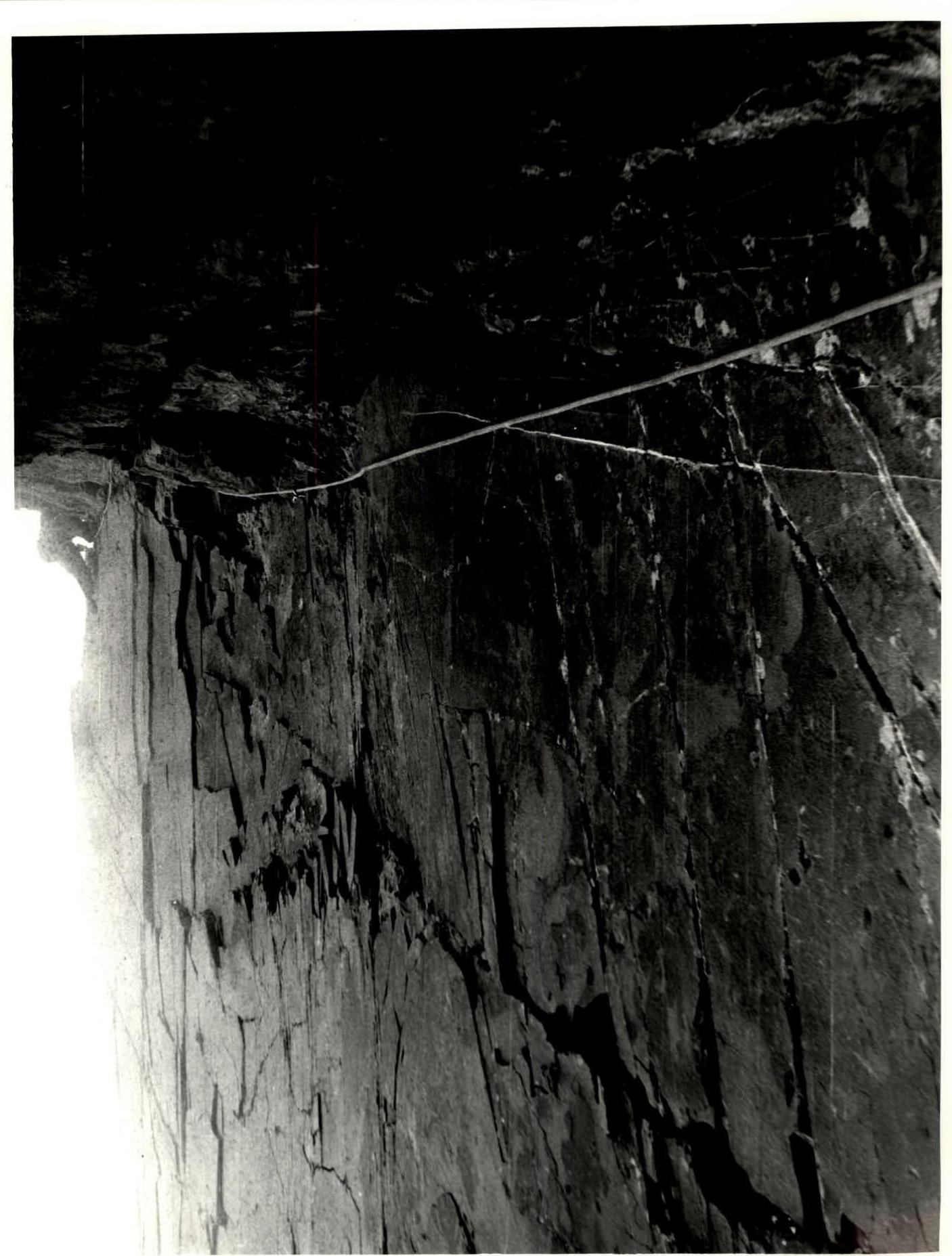
Photo 2: Passing the upper part of the inner angle, section 10–11. Taken from R4, at point 10. Dorro K.E. working.
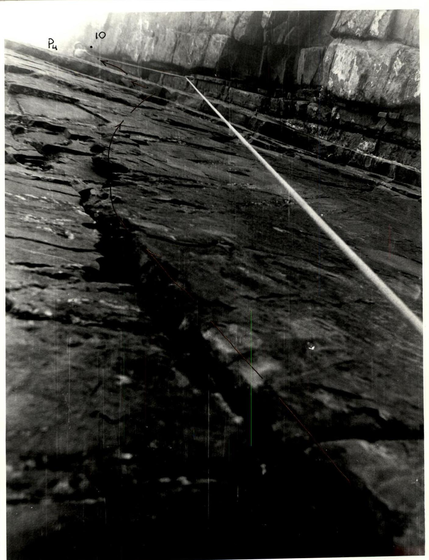
Photo 1: Inner angle, section 9–10. The location of the R4 belay station is visible. Taken from point 9, while passing the rope fixed points. The rock flakes that one hits after a pendulum swing are visible.
Route Description
From the Eastern cirque of Mt. Bodonai (3650 m), move toward the left couloir of the Northeast wall; the steepness gradually increases, hard firn (crampons, helmets!). At the entrance, an avalanche gully, possibly bare ice; it is advisable to pass quickly. Then straight up, depending on the couloir condition, possible sections of bare ice. Before the rock step in the upper part of the couloir R0, the ice is thin, and it's advisable to use an ice screw. Straight up to R1 and then slightly rightward to reach the rocks (crampons to R2) and along the slabs rightward up to the inner angle, behind it R2 (an ice screw is hammered in), then rightward up along the slabs and flakes to a convenient ledge (R3) 10 m below the start of the right inner angle (the left inner angle is shorter but much more difficult). The rocks are made of strong black sandstone with quartzite veins, narrow cracks, oblique flakes, and outward-facing holds.
From the belay station, leftward to a rock flake and then along it rightward into the inner angle; at its start, a piton and a control cairn on it. The slabs to the left of the angle are tile-like; the right wall of the angle slightly constricts; the cracks on it are in moss and slightly open outward. Work in the middle part on aid (friends, but rock stoppers and pitons also work); in the upper third of the angle, an unpleasant spot: on a chock, a 3 m pendulum leftward to a rock flake and along it rightward up, again into the angle to an oblique uncomfortable ledge, here R4. Then up the angle — the relief is more pronounced, climbing is mostly on jamming. Exit onto the SE ridge and on it — an oblique platform R5. Then along the couloir between two ridges and a chimney to the crest. The summit — a large cairn (4049 m), according to other data — 4053 m.
Descent: SW for about 100 m to a saddle, then along snow and firn, rightward and then northward to the Bodonai pass (3946 m, 2A tourist category), then rightward into the Bodonai valley, staying left of the NNE ridge (in reports, NE) along a snowy slope (steepness up to 45°).
Attention! In case of avalanche danger, descend along the ridge.
Further, slightly rightward and along the moraine to the [unspecified location] (1.5 hours).
This route was attempted by a group of the same composition on January 4, 1994, but due to heavy snow cover, frost, and route difficulties, and lack of insurance, they returned from point 6 (R2).
Map-Scheme
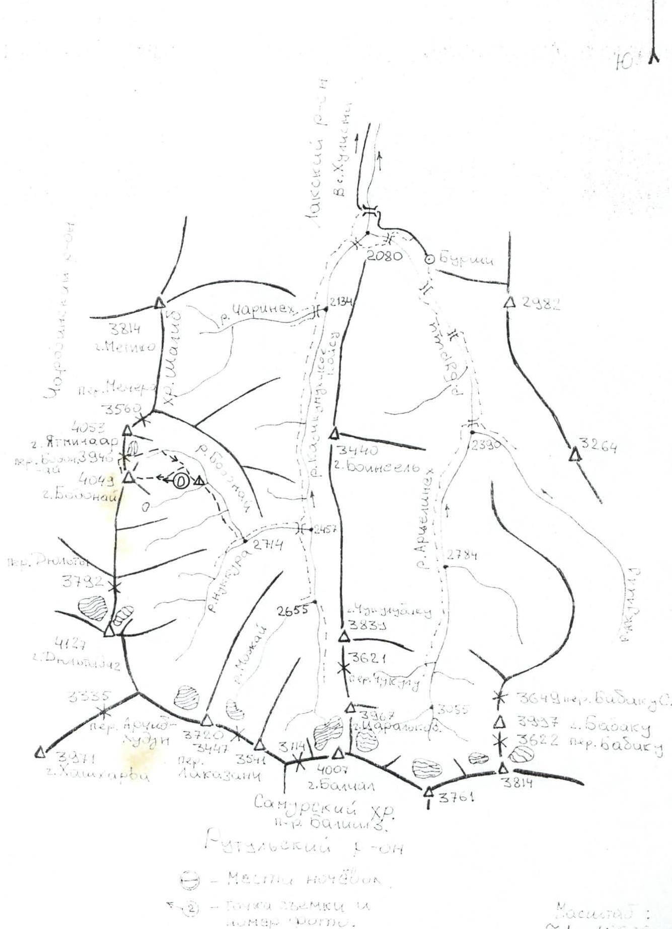
Mt. Bodonai 4049 m. via the Northeast wall, 4A category of difficulty. Region 2.10. Dagestan mountains, Shalib ridge.