
Ascent Passport
-
The route is combined
-
2.96 – Dagestan mountains (2.9 East Caucasus)
-
Ascent to Mt. Bali-al (4007 m) via the Eastern ridge, first ascent
-
Proposed category – 1B, reg. No 548, 4.7. 16/4–85
-
Route characteristics:
- length – 810 m
- total elevation gain – approx. 550 m
- average steepness – 35°
- length of categorized sections:
- 1st – 540 m
- 2nd – 270 m
- Pitons driven: for belay, for creating ITO:
- rock: 1
- ice: –
- No overnight stays on the route
- Total time on the move – 5 h 20 min
- Participants:
- Timoshin M.E. – Master of Sports
- Akhmedkhanov K.E. – 2nd sports category
- Zainulin E.G. – 2nd sports category
- Ibragimov R.M. – 2nd sports category
- Magomedov G.F. – 2nd sports category
- Ibragimov I.I. – 3rd sports category
- Arefiev B.A. – badge holder
- Churein B.S. – badge holder
- Coach – Master of Sports Timoshin M.E.
- Date of departure and return – October 7, 1965
Brief characteristics of the summit
The trapezoidal peak Bali-al (4007 m) is located on the Samur ridge. To the north of the summit, a high ridge Artse-lin-ekh (Chukul) branches off, and to the south, a short spur. On the northwestern slope lies a glacier of the same name as the peak, giving rise to the Kazikumukh Koisu River. The northeastern slopes feature large firn and snowfields, serving as the source of the Artse-lin-ekh River. To the east of Bali-al lies Mt. Babaku (3997 m), to the north Mt. Tsaralkov (3967 m), and to the west Mt. Dyulty-dag (4127 m). The southern slopes and ridges of the mountain descend to the Dyulty-chai River, while the northern rock walls drop into the vast cirques of the upper reaches of Kazikumukh Koisu and Artse-lin-ekh.
The nearest peak with established routes is Dyulty-dag (1B, via the Western slope and 2A, via the Northern ridge).
Description of the approach to the route
From the regional center, village Kumukh, by passing transport to the village Burshi (30 km). Beyond the village, cross to the left bank of the Burshi River. After 2 km, cross to the right bank and after another 2 km, again to the left bank. Follow it to the confluence of the Artse-lin-ekh River with Burshi. Without crossing Artse-lin-ekh, proceed up the gorge to the cirque. In the upper reaches of the river, on a plateau – camp (approx. 3100 m, 2 hours from v. Burshi).
From the camp:
- via scree
- and old, destroyed moraine
- to the firn field (approx. 3490 m) – 1.5 hours.
Route description
Up the firn slope, bypassing ice lenses, towards visible rock outcrops. To the left, a rocky northern spur begins on the Samur ridge. A steep rocky slope is traversed diagonally to the right and upwards. Rock steps are destroyed (rockfall, pitons). From the start of the route – 1 hour 20 minutes.
The rocky-snowy eastern ridge of the summit leads to a sub-summit (cornices, protrusions). From the sub-summit, the ridge changes direction to northeast. The ridge is:
- rocky,
- narrow,
- forming a wall to the north.
At the summit – a cairn. From the point of reaching the Eastern ridge – 2 hours 30 minutes.
Descent follows the ascent route. Total time spent on the ascent from the camp – 6 hours 20 minutes.
Table of route sections to Mt. Bali-al
| Date | Designation | Average steepness | Length m | Relief characteristics | Difficulty | Relief condition | Weather conditions | Category of difficulty | Pitons: rock | Pitons: ice | Protrusions |
|---|---|---|---|---|---|---|---|---|---|---|---|
| October 7, 1965 | R0–R1 | 30° | 250 m | firn | 1 | Closed firn field with ice layers | continuous cloud cover, snowfall | – | – | – | – |
| R1–R2 | 45° | 80 m | rocks | 2 | stepped rocky slope | fog, snow | 1 | 1 | – | 1 | |
| R2–R3 | 35°–40° | 380 m | ridge | 2–1 | snow-rock ridge | fog, snowfall, wind | – | – | – | 2 | |
| R3–R4 | 30° | 100 m | ridge | 1 | sharp rocky ridge | fog, strong wind | – | – | – | – | |
| R0–R4 | 35° | 810 m | 1 | 1 | – | 3 |
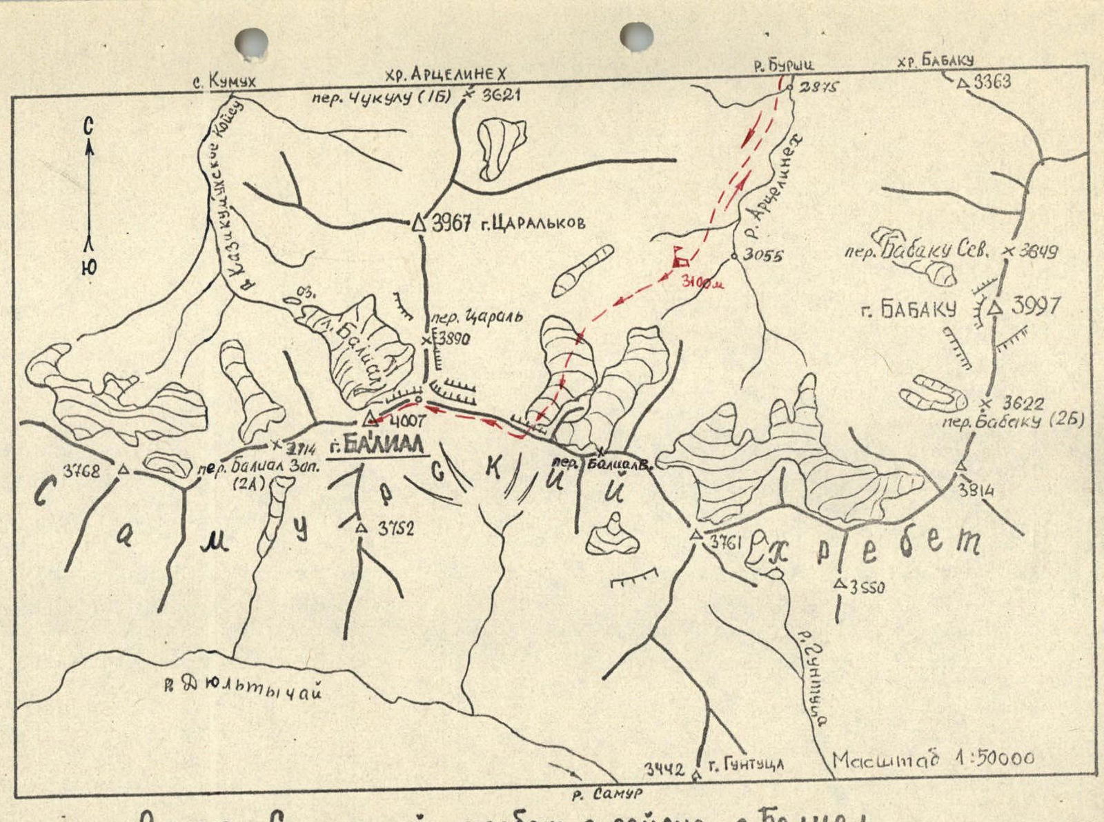
Diagram. Samur ridge in the area of Mt. Bali-al.

Route diagram in UIAA symbols
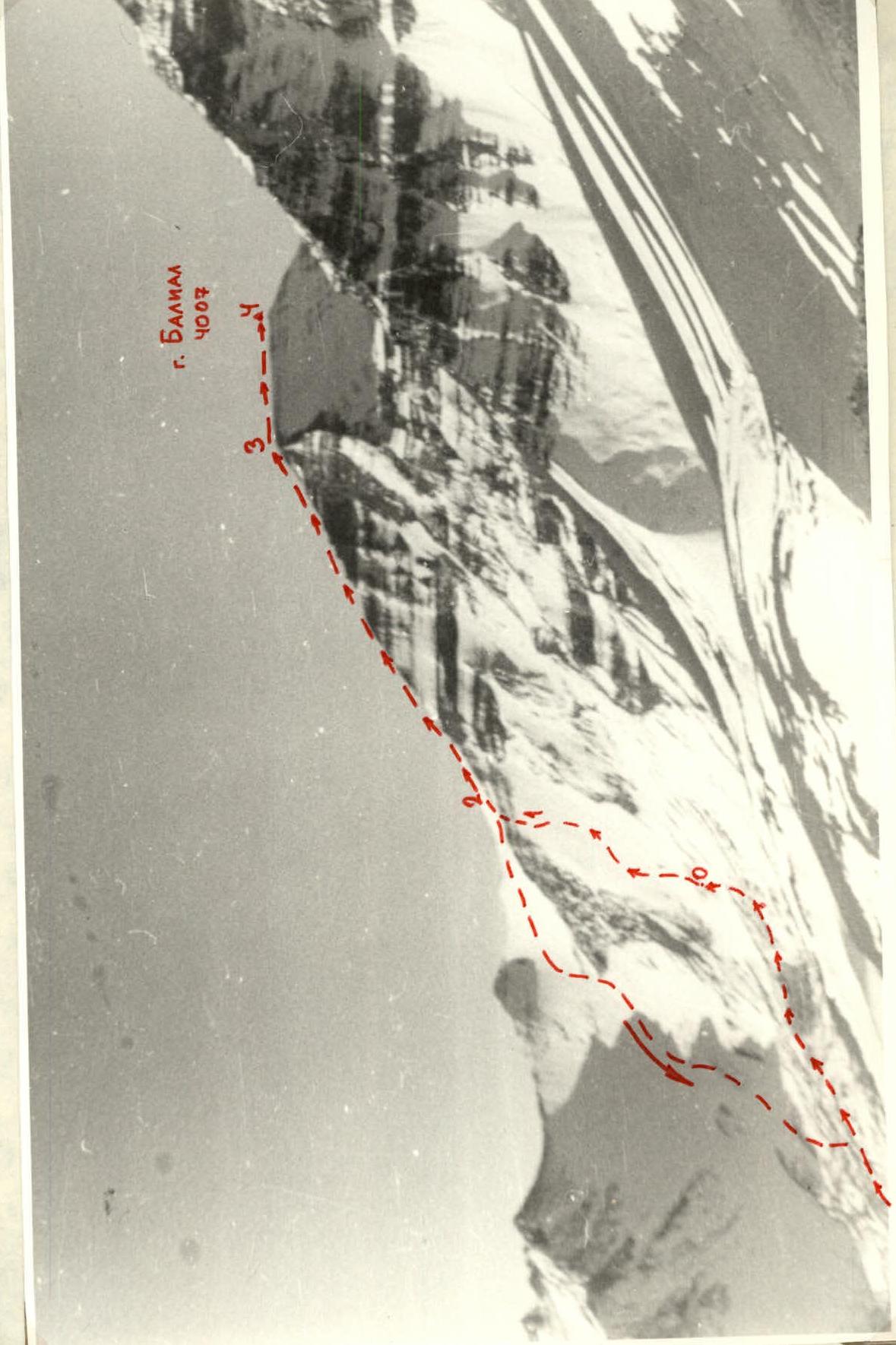
Ascent route to Mt. Bali-al. View from the north, from the spur of the Artse-lin-ekh ridge
Comments
Sign in to leave a comment