13
I. Climbing category — Combined 2. Climbing area — 2.9. Eastern Caucasus 3. Peak, its height and ascent route — Bazardyuzi (4466 m) via N ridge 4. Expected difficulty category — 2B cat. diff. 5. Route characteristics: height difference — 2338 m average steepness — 45° section lengths: I—2500 m, II—200 m, III—70 m, IV—40 m, V—200 m, VI—250 m, VII—40 m, VIII—350 m 6. Number of pitons driven: for belay for creating belay stations rock — 0 0 ice — 13 0 bolt — 0 0 7. Number of travel hours — 14 h 8. Number of nights and their characteristics — overnight stay in the base camp near Kurush village 9. Full name of the team leader and participants, their sports qualification Melnikov V.M. — Pr. — team leader Suldin Yu.A. — ShR. Volkotrub Yu.V. — ShR. Smirnov V.V. — ShR. 10. Team coaches — Dubov K.K., Nezametdinov A.B. 11. Date of departure and return — September 8, 1979

Route description
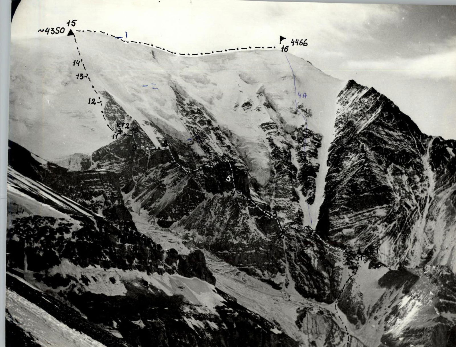
Move from Kurush village to the bridge over Chakhyrtchai River. After crossing the bridge, follow a grassy and then scree ridge, which is the beginning of the N ridge of Bazardyuzi peak, and continue to a rock outcrop. From Kurush village — 5 hours (section R0–R1).
Through moderately difficult rocks (200 m) — exit below the wall, belay is alternating via protrusions (section R1–R2).
The wall (70 m) is climbed via a central cleft, piton belay (section R2–R3).
Then follow a short (5–10 m) ridge to the next wall (40 m), which is also climbed via a cleft with piton belay (section R3–R4).
Then along the ridge with alternating, partly simultaneous belay, we reach a rock blade (200 m) (section R4–R5).
Along the rock blade with alternating belay via protrusions (250 m, section R5–R6), and then via easy rocks — exit below a snow-ice slope to a control cairn (40 m, section R6–R7).
Further along the snow-ice slope, belay via ice screws, exit to the summit (350 m, section R7–R8).
Descent from the summit along the W ridge to Vakchag pass, and then from the pass move rightwards towards Kurush village.
Additional information on the route. We do not recommend this route as a first 2B category route.
Excerpt from the protocol of the analysis of the first ascent to Bazardyuzi peak via the N ridge, approximately 2B category.
Conclusion of the reviewer: Korkin I.V.: "Ascent is confirmed and recommended to be submitted to the classification commission as a 2B category route."
Table
Brief overview of the climbing area
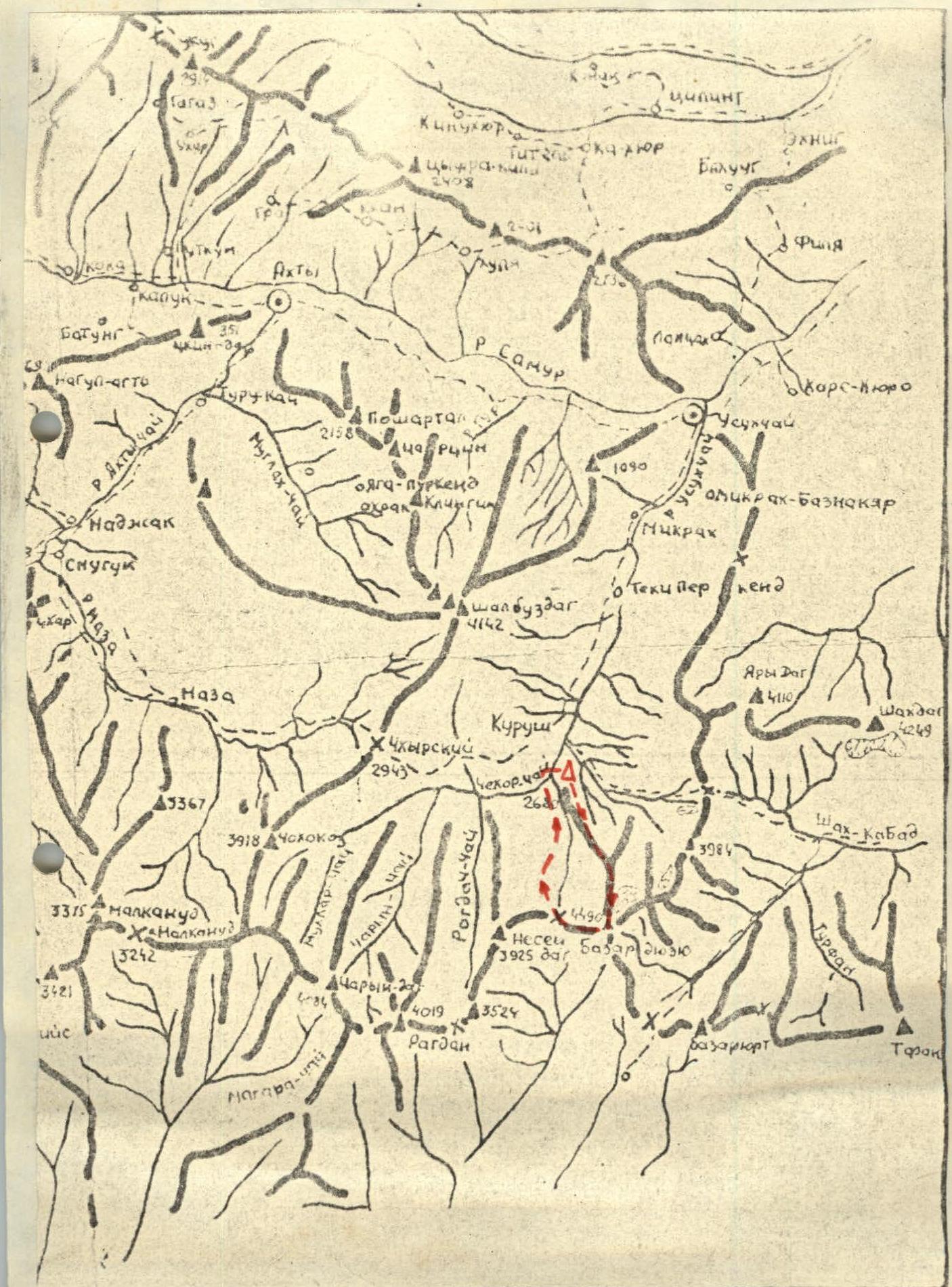
Bazardyuzi peak is the highest point in Dagestan and Azerbaijan. It is located in the Main Caucasian Range. The commonly accepted height is 4466 m, but some sources indicate a height of 4485 m. The peak is a nodal point. From here, the Main Caucasian Range sharply turns to SSE, and the Yarydag ridge branches off to NE. The mountain is composed mainly of shale with outcrops of sandstone and limestone. The northern cirque, formed by the NE ridge and N edge, contains two glaciers: Murkar and Tikhitsar. In the upper part, both glaciers merge, and starting from an altitude of 3800 m, they are separated by the Northern counterfort, along which the proposed route is laid.
Historical background:
- The first ascent to Bazardyuzi was made in 1873 by Russian topographer Alexandrov with Cossacks (from Kurush pass, 1B category).
- There are oral reports that a group of instructors from "Zvezdochka" alpine camp led by Anokhin G.I. ascended to the summit "via the northern ice slope" in 1952.
- Our group chose this route in 1978 and took photographs.
- In November 1981, a group led by Kudryavtsev A.I. reached point R1 and returned due to bad weather.
- In October 1982, a group led by V. Leonov was unable to ascend higher than the advance camp due to a hurricane.
Approach. From Kurush village, follow a trail towards Kurush pass for 1.5 hours. From a characteristic shale "gully", turn right along a small trail. From here, head towards the counterfort. Leaving a huge ice arch to the right, reach the base of the Northern counterfort. Camp under boulders shaped like parallelepipeds.
- From Kurush village: 3–4 hours
- Altitude: 3000 m
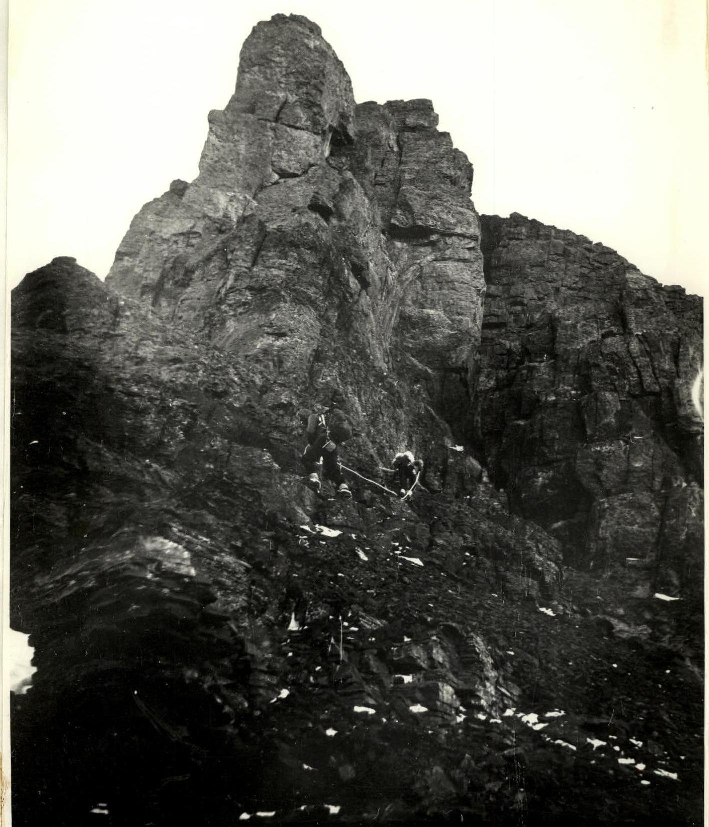
Photo 3. Upper part of section (R2–R3). Taken from a gendarme (point R2, photo 2), January 3, 1984, during the second ascent by S. Smotrov's group. Lens T-22, F = 75 mm. In the background, the wall R4–R6 is visible.

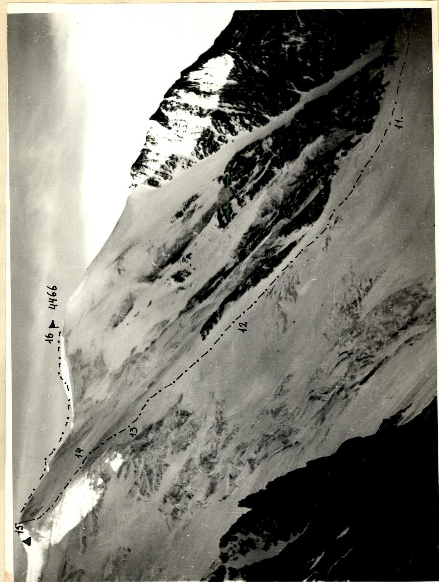
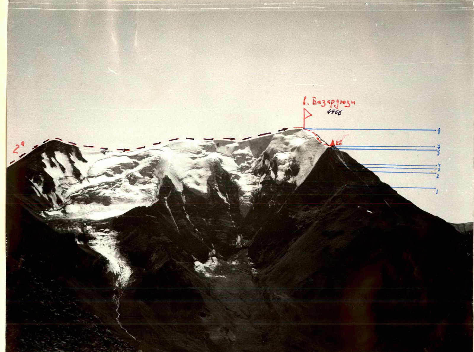
Photo 1. Profile of the upper part of the route from the left. January 1, 1984. Lens T-22, F = 75 mm. From the Eastern ridge of Bazardyuzi peak.
- Altitude: 3950 m
- Distance: ~1.5 km
Brief description of the route
Exit to the route in 4 hours. Movement along the ridge sections of the counterfort is mostly simultaneous. Difficult gendarmes (2–4 m) are climbed directly. Wall sections (R2–R3, R4–R6, R7–R8, R9–R10) are formed by outcrops of sandstone and limestone. Belay! The upper part of the R9–R10 wall is heavily damaged. The key section of the rock part is R4–R5. On the ice part of the route, section R13–R14 is bare ice, polished by winds blowing here all year round. Belay!
Bivouacs are possible:
- near control cairns
- on the Eastern ridge
Descent:
- along the Eastern ridge (4–5 hours)
- possible descent along the Western ridge (2–3 hours) via Vakchag pass.
When selecting gear, consider the continuous wind on the ridge, which often turns into a storm.
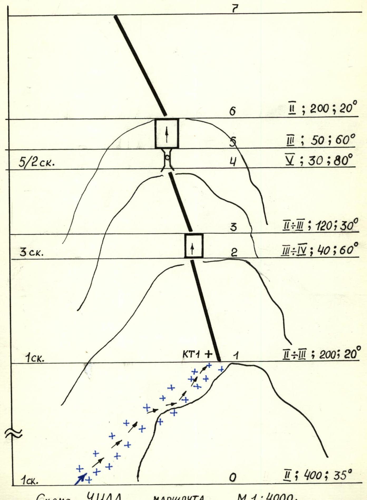
UIAA route diagram. Scale 1:4000.
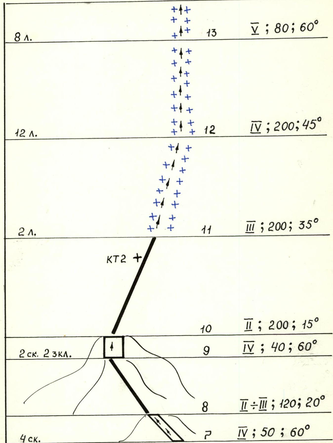
UIAA route diagram (continued). Scale 1:4000.
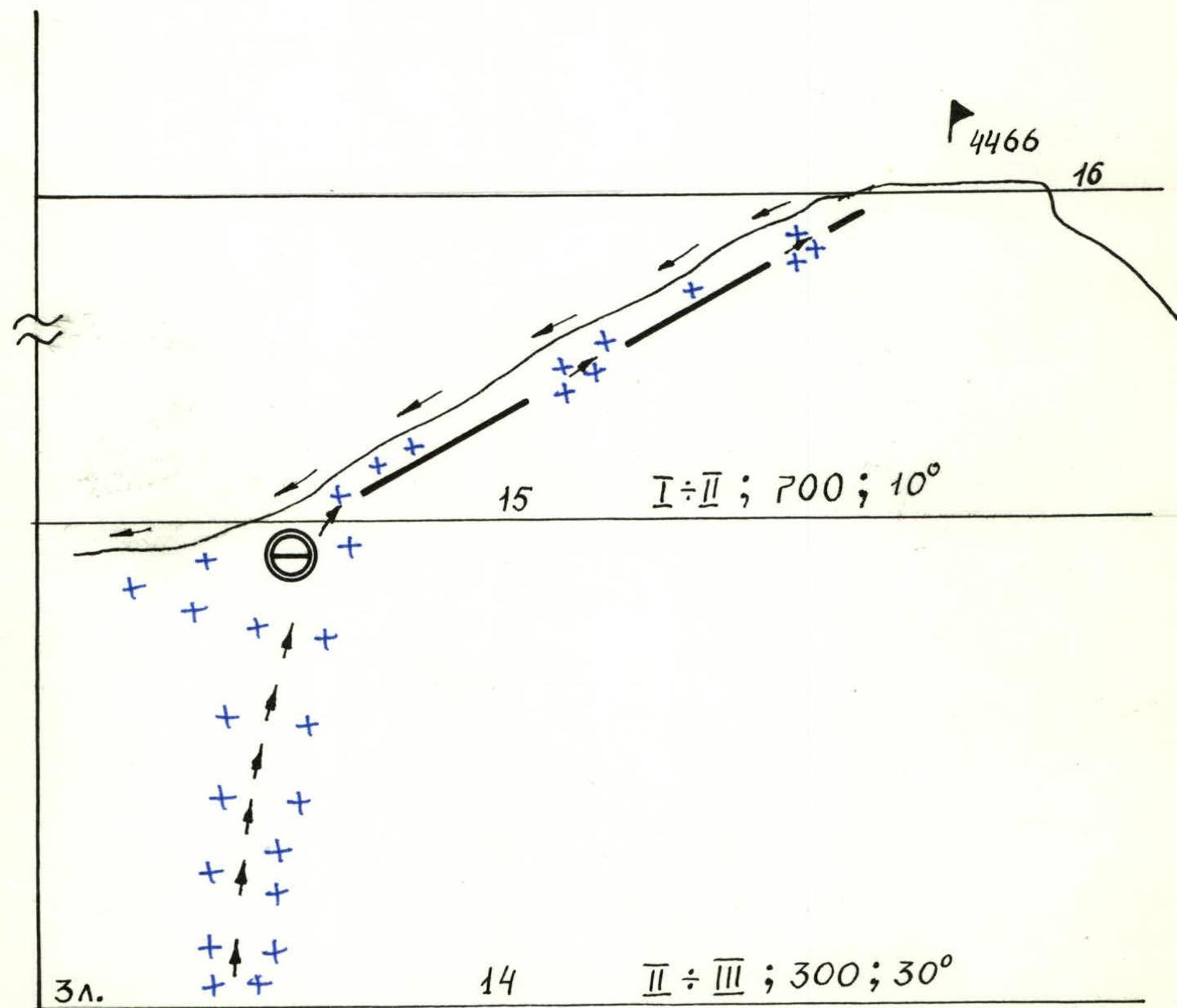
UIAA route diagram (continued). Scale 1:4000.
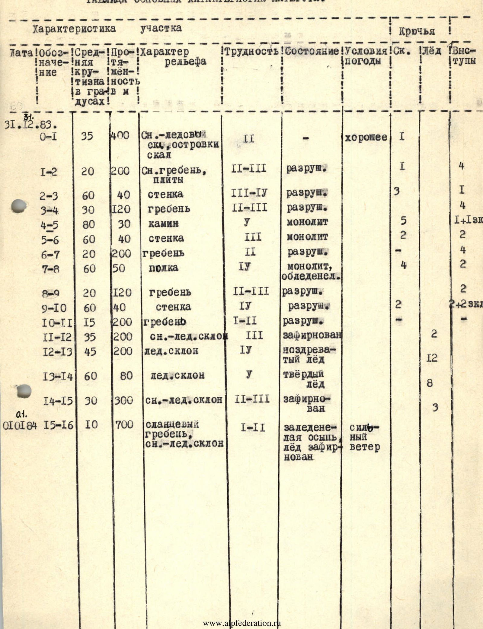
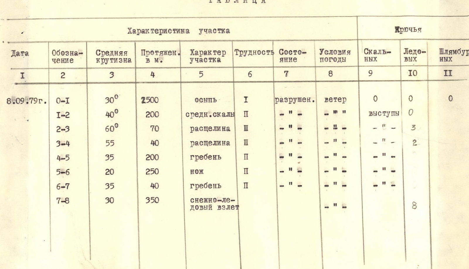
Table of main route characteristics
| Date | Section | Average steepness | Length in m | Terrain characteristics | Difficulty | Condition | Weather conditions | Rock pitons | Ice screws | Protrusions |
|---|---|---|---|---|---|---|---|---|---|---|
| September 8, 1979 | R0–R1 | 30° | 2500 | scree | I | destroyed | wind | 0 | 0 | 0 |
| R1–R2 | 40° | 200 | medium rocks | II | " | " | protrusions | 0 | ||
| R2–R3 | 60° | 70 | cleft | III | " | " | " | 3 | ||
| R3–R4 | 55° | 40 | cleft | III | " | " | " | 2 | ||
| R4–R5 | 35° | 200 | ridge | II | " | " | " | - | ||
| R5–R6 | 20° | 250 | blade | II | " | " | " | - | ||
| R6–R7 | 35° | 40 | ridge | II | " | " | " | - | ||
| R7–R8 | 30° | 350 | snow-ice slope | " | 8 | |||||
| December 31, 1983 | R0–R1 | 35° | 400 | Snow-ice slope, rock outcrops | II | - | good | I | ||
| R1–R2 | 20° | 200 | Snow ridge, slabs | II–III | destroyed | I | 4 | |||
| R2–R3 | 60° | 40 | wall | III–IV | destroyed | 3 | 1 | |||
| R3–R4 | 30° | 120 | ridge | II–III | destroyed | 4 | ||||
| R4–R5 | 80° | 30 | chimney | V | monolith | 5 | 1+1 stopper | |||
| R5–R6 | 60° | 40 | wall | III | monolith | 2 | 2 | |||
| R6–R7 | 20° | 200 | ridge | II | destroyed | - | 4 | |||
| R7–R8 | 60° | 50 | shelf | IV | monolith, icy | 4 | 2 | |||
| R8–R9 | 20° | 120 | ridge | II–III | destroyed | 2 | ||||
| R9–R10 | 60° | 40 | wall | IV | destroyed | 2 | 2+2 anchor pitons | |||
| R10–R11 | 15° | 200 | ridge | I–II | destroyed | - | ||||
| R11–R12 | 35° | 200 | snow-ice slope | III | icy | 2 | ||||
| R12–R13 | 45° | 200 | ice slope | IV | porous ice | 12 | ||||
| R13–R14 | 60° | 80 | ice slope | V | hard ice | 8 | ||||
| R14–R15 | 30° | 300 | snow-ice slope | II–III | icy | 3 | ||||
| January 1, 1984 | R15–R16 | 10° | 700 | shale ridge, snow-ice slope | I–II | icy scree, icy | strong wind |