
Ascent Passport. I. Route is combined (K)
- 2.96 mountains of Dagestan (East. Caucasus)
- Ascent to the peak Babaku, 3997 m via ridge 10
- Presumed category of difficulty — 1B
- Route characteristics: — length — 900 m — total elevation gain — 790 m — average steepness — 40°
- Pitons were not used
- The route was completed without intermediate bivouacs
- Total time in motion — 7 hours
- Full name of the leader and participants, their sports qualification:
- Osmanov M.G. — 2nd sports category
- Akhmedkhanov K.E. — 2nd sports category
- Pashuk E.G. — 3rd sports category
- Rassudishkin S. — 3rd sports category
- Kamayeva S.N. — badge holder
- Team coach — Akhmedkhanov K.E.
- Date of ascent — July 9, 1974
Brief characteristics of the summit. The sharp pyramid of Mount Babaku (3997 m) — translated from Lak as "needle mountain" — is located in the northern spur of the Samur ridge. To the north, the summit is bounded by the Babaku North pass., while the southern ridge descends to the Babaku pass (3622 m). On the southwestern slope, there is an unnamed glacier (conditionally Babaku-III), and on the southeastern slope, glacier No.20 (conditionally Babaku-II). The northern spur separates the valleys of the Arcelinekh and Akulalu rivers, which belong to the Kazikumukhskoe Koix-su basin. Mount Babaku is composed of strong clay-sand schist, the outcrops of which, in the form of five rock belts, give the summit a pyramidal shape. To the north of the mountain lies peak Bersenau, 3887 m, to the south — an unnamed peak 3904 m, to the west — peak Batial, 4007 m.
In the Babaku area, ascents were made to Batial (1B, is listed in the classification of the USSR Climbing Federation), to peak 3904" (n/k, led by G. Anokhin, 1972), to peak Caral'kov (n/k, 3967 m, led by G. Svinarev, 1981), and to peak Chukulubaku (n/k, 3839 m, led by K. Akhmedkhanov, 1974).
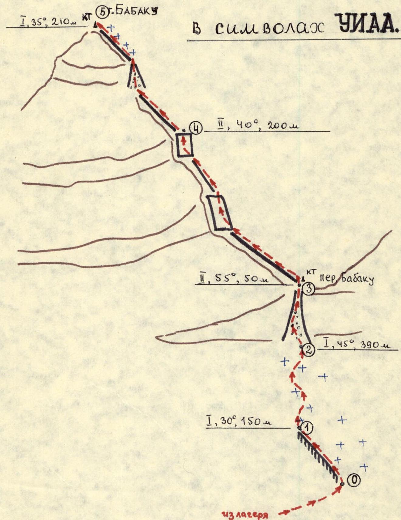
Description of the approach to the route. From the district center, village Kumukh, by passing transport to the village Burshi (30 km). From the village, follow the trail along the banks of the Burshi and Arcelinekh rivers to a huge cirque in the upper reaches of Arcelinekh. Here, at an altitude of 3055 m, on the right bank of the river, is the base camp. From Burshi, it takes 2 hours 30 minutes. From the camp:
- Across scree and ribbon snowfields
- To the base of the right-bank moraine of glacier No.17 (from the camp, 1 hour 30 minutes).
Route description. Along the moraine, exit onto glacier No.17. Until August, the glacier is snow-covered. Move along the axis of the glacier up to the base of the rock wall. Left (in the direction of travel) of the Babaku pass, in the wall, there is a snow-filled couloir (rockfall from the pass ridge!). Through the couloir, 12–14 m, exit onto the southern ridge of peak Babaku. From the start of the route, it takes 1 hour 40 minutes. On the pass, there is a control cairn. Along firm scree, reach the first rock belt. The belt is climbed directly (rockfall!). Then a steep snow slope leads to the second rock belt, which is climbed diagonally to the right and upwards. The rocks are firm, with many protrusions for belay. Along the snowy ridge, reach the base of the third belt.
- 30 m to the east of the ridge, in the belt, there is a couloir (17 m, firm scree), through which you exit onto the sub-summit.
- The ridge becomes gentler and leads to the summit.
- Control cairn.
- From the pass, it takes 2 hours 20 minutes.
Descent to the camp follows the ascent route (2 hours).
Table of main sections
| Date | Designation | Steepness (°) | Length (m) | Terrain character | Difficulty | Condition | Weather | Pitons | ||
|---|---|---|---|---|---|---|---|---|---|---|
| Rock | Ice | Protrusions | ||||||||
| July 9, 1974 | R0–R1 | 30° | 150 | Moraine | 1 | Frozen fine-grained | Clear | - | - | - |
| —"— | R1–R2 | 45° | 290 | Glacier | 1 | Snow-covered, with some ice outcrops | —"— | - | - | - |
| —"— | R2–R3 | 55° | 50 | Slope and couloir | 2 | Rocky-scree. Some ice patches | —"— | - | - | 1 |
| —"— | R3–R4 | 40° | 200 | Ridge | 2 | Scree with rock outcrops | —"— | - | - | 2 |
| —"— | R4–R5 | 35° | 210 | —"— | 1 | Rocky-scree | Wind | - | - | - |
| R0–R5 | 40° | 900 | - | 1–650n | - | - | - | - | 3 |
Route scheme
Comments
Sign in to leave a comment