ASCENT PASS
- Ascent class: rock
- Ascent area: №2.9 (East Caucasus, Bogossky Ridge)
- Peak, its height and route: Addala-Shukhgelmeэр East, 3970 m, via the northern counterfort
- Proposed difficulty category: 2B
- Route characteristics: height difference — 770 m, average steepness — 50°, section duration: R1–500 m, R2–250 m, R3–250 m, R4–220 m, R5–120 m
- Number of driven pitons:
- rock: 3
- ice: 1
- bolt: – for belay, for creation, etc.
- Number of overnight stays and their characteristics: no overnight stays
- Number of travel hours: 10–12
- Full name of the leader and participants, their sports qualification:
- Kozorezov Evgeny Fedorovich, 1st sports category
- Yakhyaev Ruslan Krymsoltanovich, 1st sports category
- Kudryavtsev Anatoly Ivanovich, 1st sports category
- Mirzaev Abdulla Magomedovich, 1st sports category
- Team coach: MS Timoshin M. E.
- Date of departure on the route and return: July 25, 1979

3 — section designation
- Summit
- Ascent route
- Descent route
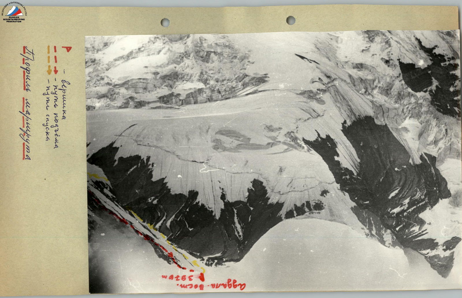
Table of route sections to the summit Addala-Shukhgelmeэр East (3970 m) via the northern counterfort 2B category of difficulty tentatively
| Date | Designation | Average steepness in ° | Length in m | Terrain character | Difficulty | Condition | Weather conditions | Rock | Ice | Bolt |
|---|---|---|---|---|---|---|---|---|---|---|
| December 25, 1979 | R1 | 40° | 500 m | glacier | 1 | Firm firn | normal | – | – | – |
| R2 | 45° | 250 m | talus, rocks | 1 | Average talus, heavily destroyed rocks | cold wind | – | – | – | |
| R3 | 50° | 250 m | firn slope | 1 | Firm firn | – " – | Simultaneous belay | |||
| R4 | 45° | 220 m | rocky counterfort | 2 | Easy and medium difficulty rocks, heavily destroyed | calm | 3, alternate belay via ledges | |||
| R5 | 50° | 180 m | snow-ice slope | 2 | Slightly snow-covered ice | – " – | 1, step cutting |
Base camp approach diagram
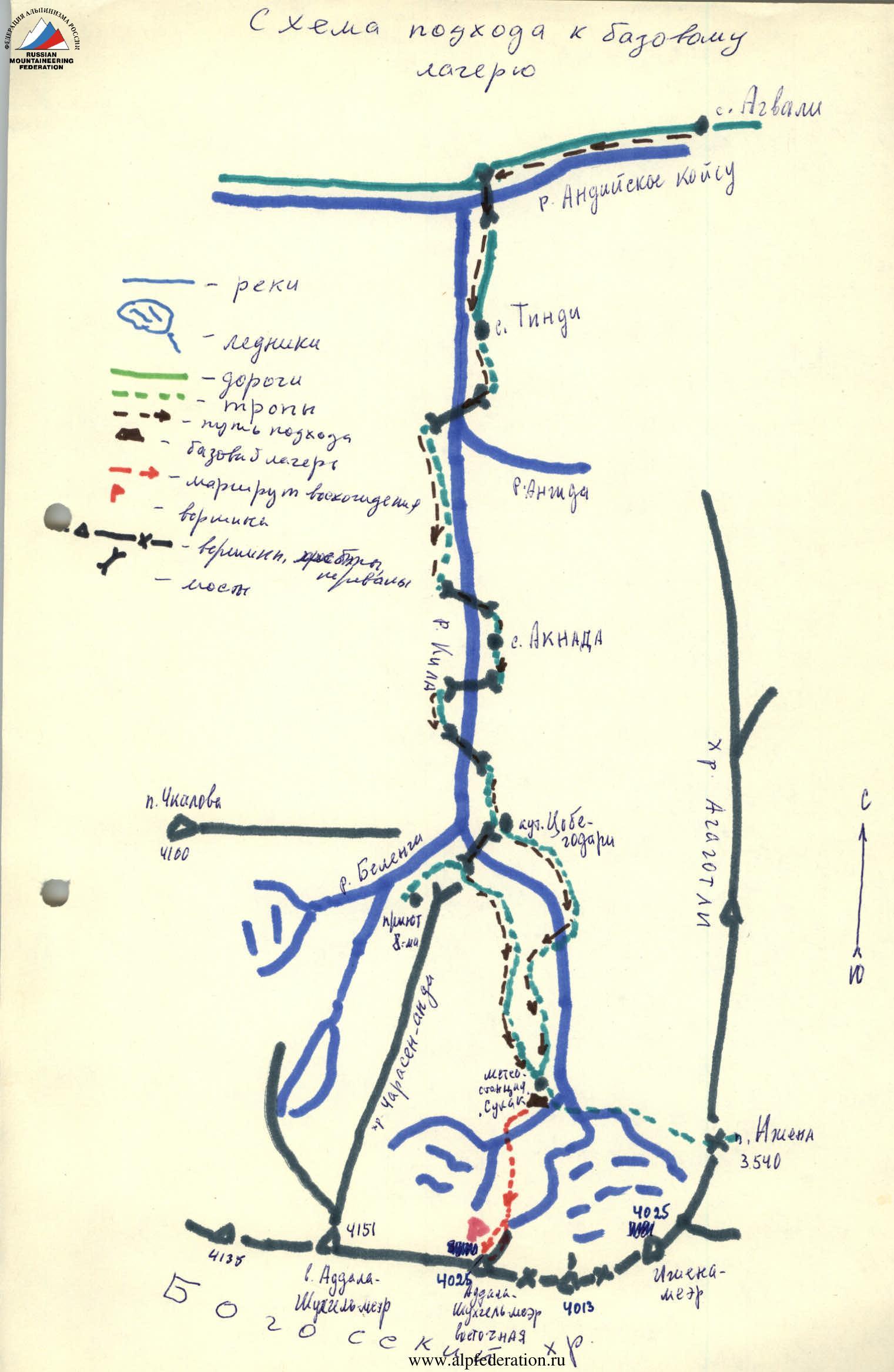
Description of the approach to the base camp
From the administrative center of the TsUMADINSKY district of the DASSR, the village of Agvali, to the village of Tindi — 15 km of automobile road. From the village of Tindi upstream along the Kila river valley leads a well-trodden trail, which goes along the right (orographic) bank of the river until the confluence of the Kila and Angida rivers (2 hours' walk from Tindi).
From the confluence:
- the trail crosses to the left bank;
- 400 m before the village of Aknada, it again crosses to the right bank via a suspension bridge.
On the path segment from the village of Aknada to the Cobe-godari kutan (2 hours from Aknada):
- the trail once crosses to the left bank (before a small talus).
From the Cobe-godari kutan, follow:
- having crossed the bridge;
- move along the serpentine trail onto the slope of the spur of the Addala-Shukhgelmeэр — Charasen-anda mountain;
- along which the trail, after 2–2.5 hours, traversing practically without losing height the alpine meadows, leads to the "Sulak-high-mountain" meteorological station.
The meteorological station is located at an altitude of about 2960 m on the edge of the lateral moraine of the South Addala glacier.
In winter and spring:
- one should go from Cobe-godari along the right (orographic) trail, traversing the slopes of the Agagotli ridge above the canyon. The trail is marked with stakes and cairns.
Route description
From the "Sulak-high-mountain" meteorological station, head southwest along the left-bank moraine and, 100 m before the icefall, cross the glacier in a southerly direction (1 hour from the meteorological station). Then ascend the firn cone to the talus (1 hour) and then move along it, crossing one-and-a-half to two-meter vertical rock walls. Having reached the firn slope, cross it from left to right upwards and approach the left edge of the rocks of the northeastern counterfort (flow ice).
Further:
- ascend the heavily destroyed easy and medium difficulty rocks of the counterfort (3 pitons, belay via ledges) to the snowy saddle. Here is a control cairn (3–4 hours from the glacier).
Then:
- simultaneously ascend the steep snowy slope;
- 40 m from the summit (depending on the snow cover condition) cut steps (1 ice piton, rope railing);
- climb onto the rocks;
- 10 m higher, a cairn is constructed.
The summit is a snowy-icy ridge (2.5–3 hours from the saddle).
Descent:
- along the eastern ridge. Three rappel pitches to rocky outcrops.
- then with alternate belay descend to the first pinnacle, from which descend leftwards along the rocks to the firn slope.
- then by glissade to the talus and then via the ascent route.
The entire route takes 10–12 hours for a group of 4–6 people.