
Brief Overview of Mt. Kuro Area
Mt. Kuro is located in the ridge separating the Hde gorge from the Darial gorge. The western slopes of the peak descend to the village of Kazbegi. From this side, two routes of category 2B difficulty lead to the summit.
The eastern ridge, together with Mt. Shino, forms a vast cirque filled with moraine formations. The cirque is separated from the Darial gorge by the southern ridge of Mt. Kuro, which connects to the northwestern ridge of Mt. Shino and has a depression down to 3500 m at the junction. A category 1B route follows this ridge, accessing it through the cirque between Kuro and Shino at the depression.
Several routes of 2nd and 3rd category difficulty have been climbed by various groups on the southern slopes of the eastern ridge in search of a route along the southern ridge.
At a pronounced elevation (often mistaken for the summit of Kuro), a distinct ridge with steep slopes, rocky and icy, branches off the eastern ridge to the east-northeast. Together with the slopes of the main summit, these form the northern facade of the massif.
Mt. Kuro also has a sloping talus cirque on its northern side, opening onto a large terrace in the Hde gorge. The cirque is bounded to the north by the slopes of an unnamed peak about 3900 m high, and to the west by the ridge separating the Hde gorge from the Darial gorge. To the south, the cirque adjoins the eastern ridge of Mt. Kuro. No ascent to Mt. Kuro has been made from this northern cirque to date.
Group Composition
The ascent was made on May 9, 1971, by a group of climbers from Tbilisi State University, consisting of:
- Sarjveladze N.I. — 2nd category
- Tarkhnishvili D.I. — 2nd category
- Tarkhnishvili G.I. — 2nd category
- Rybinsky V.F. — 2nd category — leader
Approach
From the large terrace in the Hde gorge, head right upwards along a steep, grass-covered moraine ridge directly into the northern cirque of Mt. Kuro. It is best to organize a bivouac on the upper part of the large terrace, as there is no water in the cirque itself, and there is no safe place for belays under the route. It takes about two hours to walk from the terrace to the start of the route. There is also a bivouac site in the northern part of the cirque under the slopes of the unnamed peak.
General Characteristics of the Route
There are four feasible options for ascending Mt. Kuro from the north.
- Along the east-northeast ridge.
- Along the northern rocky-icy slope of this ridge, exiting into the area where it joins the eastern ridge.
- Along the northern edge of Mt. Kuro.
- To the col left of the large triangular gendarme and then along the north-northeast ridge to the summit.
The group chose the route along the northern edge of Mt. Kuro as the most logical. This edge drops away to the east with a sheer wall along its entire length. The western slope is steep (up to 70°) and gradually becomes less steep towards the bottom. The edge transitions into a firn dome in its upper part. It has an average steepness of 45° and a height difference of 1050 m; the total length of the edge is 1450 m (30 ropes of 50 m). The edge, which is purely rocky in its lower half, has a wall-like character; then it transitions into rocks interspersed with snowy ridges, turning into a 180-meter dome at the top.
On both sides, the edge is flanked by icy drop-offs. During our ascent, both drop-offs were "active". Therefore, caution is necessary when approaching the start of the edge. The edge itself is completely safe in its lower part, and the only danger in the upper part comes from "live" rocks.
Route Description
Cross the cirque towards a rocky outcrop a hundred meters below the start of the edge. From the outcrop, head straight up through firn to the lowest point of the edge. Then ascend 50 m along steep, complex rocks. Another rope-length of less steep rocks (Sections 1 and 2).
Reach a 15-meter gentle ridge covered in snow (Section 3).
Descend to a col and ascend one rope-length of complex rocks to reach a gentle snowy ridge with a large boulder suitable for belay (Section 4).
70 meters along the ridge (Section 5), then 50 meters of moderately difficult rocks (Section 6) lead to a triangular wall that appears to block the edge.
A 10-meter snowy ascent directly abuts almost vertical quadrilateral slabs forming the lower part of the wall. Transitioning from snow to slabs required using two channel hooks and a ladder as artificial holds. 15 meters rightwards along the slabs and upwards, then a horizontal traverse rightwards and exit onto the right face of the wall; then 50 meters straight up along steep rocks with ice and then along steep firn to a horizontal ridge (Section 7).
One rope-length along a heavily damaged rocky ridge (Section 8).
Descend to a col and ascend a complex 10-meter wall (Section 9).
Further, the edge widens, becoming a rocky slope with a significant amount of snow. Three rope-lengths along the left edge of the slope and one slightly rightwards lead to a large light-colored rocky outcrop (Section 10).
Then ascend rightwards and upwards along a steep, damaged rocky slope to exit onto a rocky ridge (Section 11).
150 meters along a wide rocky ridge with snow (Section 12), then leftwards and upwards along steep rocks and snow to a small snowy col (Section 13).
Then straight up along a steep 30-meter wall to a snowy col and another 10 meters of steep rocks.
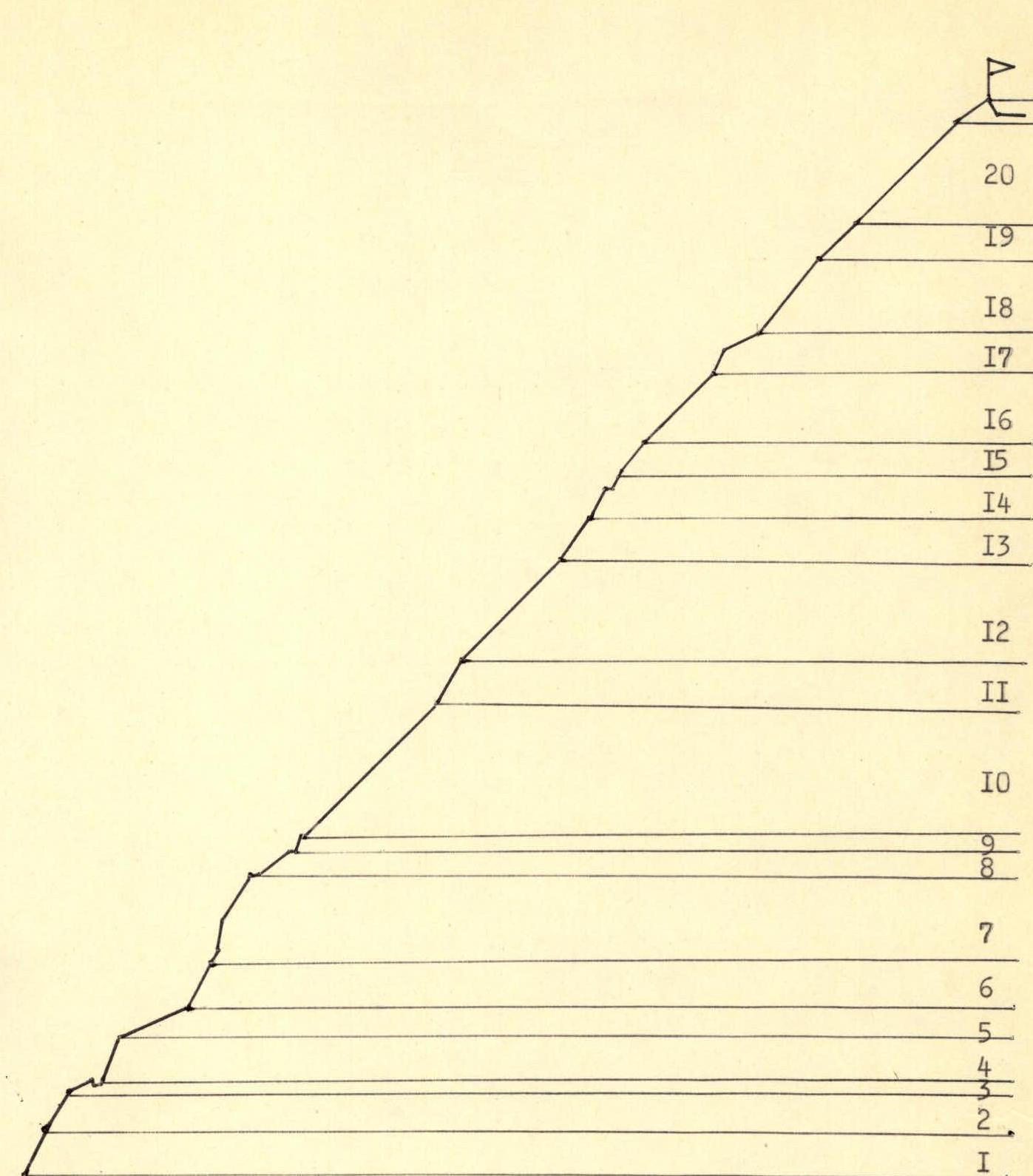
Profile diagram of the route along the northern edge of Mt. Kuro
lead to the summit of a rocky tower (Section 14).
One rope-length along steep snow and rocks leads to vertically standing boulders suitable for belay (Section 15).
100 meters along the left edge of the ridge (Section 16) lead to a rocky step with a snowy cap on top, which is ascended rightwards and upwards (Section 17).
Then again along snow and rocks on the left edge of the ridge to a large rectangular boulder overhanging the wall where the edge drops away to the east (Section 18).
From this point, the edge transitions into a dome.
- 60 meters along a steep, snow-covered slope consisting of alternating ice and rocks (Section 19).
- Four rope-lengths of very hard firn lead to the summit ridge (Section 20).
- Several rope-lengths along an almost horizontal snowy ridge with rocky outcrops in a westerly direction lead to the summit.
The route is unambiguously defined at all sections, completely eliminating any confusion in choosing the ascent path.
Descent
The descent follows the category 1B route:
- From the summit, straight down to the south to the depression in the southern ridge;
- then eastwards through the cirque between Kuro and Shino to a bivouac under Kuro.
Descent time is 1.5–2 hours.
General Remarks
Having compared the completed route with previously climbed routes of category 4B on peaks such as Ukyu, Krumkol, the traverse of Rustavi—Dzneladze, and category 5A on peaks like Ural, Tsalgmil, the group considers this route more challenging than all the above-mentioned routes. Since the route also has a high average steepness and a significant height difference, the group rates it as category 4B complexity.
Recommendations
- In summer and autumn, there will likely be ice on many sections of the route. Therefore, it is recommended to have:
- crampons for all participants;
- ice screws for belays on the dome.
- There are opportunities for good bivouacs on sections 5 and 7, as well as on the summit ridge.
- It is useful for the group to have a long (10 m) rope loop for organizing belays through large rocky outcrops frequently encountered on the route, as well as several channel hooks.
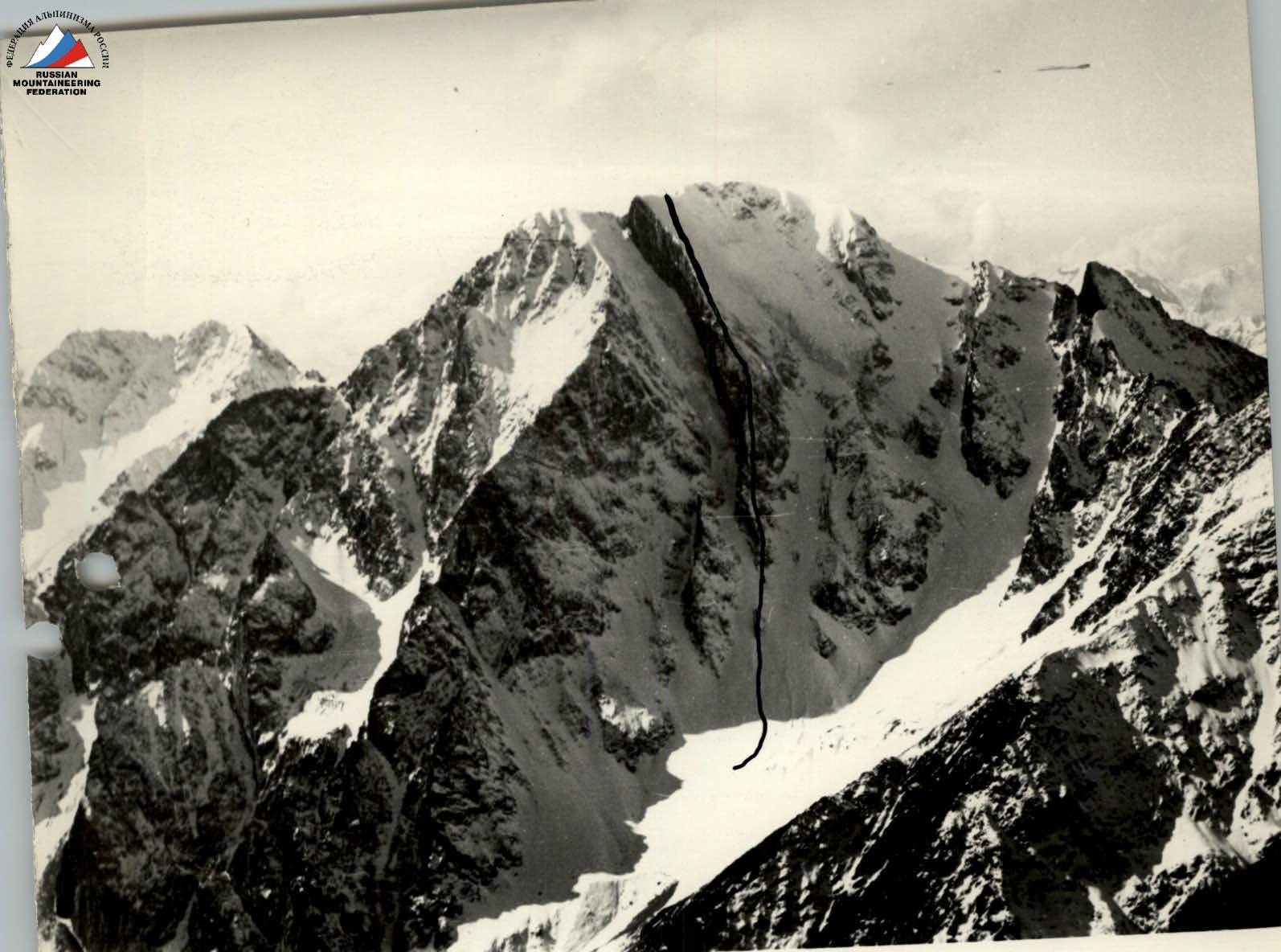
Northern slope of Mt. Kuro. View from Mt. Gori. The group's route.
The group's bivouac. In the background, section 6 and the triangular wall of section 7.
Main Characteristics of the Route by Sections
| Section # | Length, m | Average Steepness, ° | Character of Section | Difficulty | Belay | Time, h:min | Notes |
|---|---|---|---|---|---|---|---|
| 1. | 50 | 65 | monolithic rocks | difficult | pitons | 0:30 | |
| 2. | 50 | 60 | « - - - - » | « - - » | « - - » | 0:30 | |
| 3. | 15 | 30 | rocky ridge, snow-covered | easy | « - - » | ||
| 4. | 50 | 70 | monolithic rocks | difficult | « - - » | 2:00 | |
| 5. | 70 | 20 | snowy ridge | easy | loop | group's bivouac | |
| 6. | 50 | 60 | rocky ascent | difficult | pitons | 1:00 | |
| 7.a | 10 | 60 | snowy ascent | outcrop | 0:15 | ||
| 7.b | 15 | 80 | rocky slabs | difficult | pitons, loop | 0:25 | ladder |
| 7.c | 50 | 60 | rocks with ice, snow | « - - » | « - - » | 1:30 | |
| 8. | 50 | 40 | damaged rocky ridge | moderately difficult | outcrops | 0:30 | |
| 9. | 10 | 70 | rocky wall | difficult | « - - » | 0:30 | |
| 10. | 200 | 45 | damaged rocks and snow | moderately difficult | « - - » | 2:00 | |
| 11. | 50 | 60 | damaged rocks | moderately difficult | « - - » | 0:30 | |
| 12. | 150 | 45 | damaged rocks, snow | easy | « - - » | 2:00 | |
| 13. | 50 | 50 | « - - - » | moderately difficult | « - - » | 0:30 | |
| 14. | 50 | 60 | rocky tower | difficult | pitons | 1:00 | |
| 15. | 40 | 55 | snow, rocky wall | moderately difficult | outcrops | 0:30 | |
| 16. | 100 | 45 | snowy ridge, rocks | « - - » | « - - » | 1:00 | |
| 17.a | 20 | 60 | rocky step | « - - » | « - - » | 0:30 | |
| 17.b | 30 | 30 | snowy ridge | « - - » | « - - » | 0:10 | |
| 18. | 100 | 50 | rocky slope, snow | « - - » | « - - » | 1:00 | |
| 19. | 60 | 45 | ice with rocky outcrop | « - - » | « - - » | 1:00 | |
| 20. | 180 | 45 | very hard firn | « - - » | ice screw | 2:00 |
Comments
Sign in to leave a comment