- The type of ascent is combined.
- The region of ascent is Eastern Caucasus, Shavano ridge, Shandon river gorge, ChIASSR.
- Peak, its height, ascent route — peak 60 years of ChIASSR (4071 m) via the right couloir of the NE wall, first ascent.
- Assumed difficulty category — 3B.
- Route characteristics: a) height difference — 1250 m. b) average steepness — 40°. c) extent of sections: * 1st diff. cat. — 760 m. * 2nd diff. cat. — 320 m. * 3rd diff. cat. — 880 m.
- Pitons hammered for belay (for creating ITO): rock — 6, ice — 24.
- Number of travel hours on the route — 18.
- Number of overnight stays and their characteristics: one, on the southern scree slope of the pre-summit ridge, conditions are good.
- Full name of the leader, participants, and their qualifications:
- Kurochkin A. G., CMS.
- Sidenko F. F., 1st sports category.
- Khazov V. A., CMS.
- Vasilenko A. A., CMS.
- Team coach — Kurochkin A. G.
- Date of departure on the route and return to the base camp: a) departure on the route — October 8, 1984. b) reaching the summit — October 9, 1984. c) return to the camp — October 9, 1984.
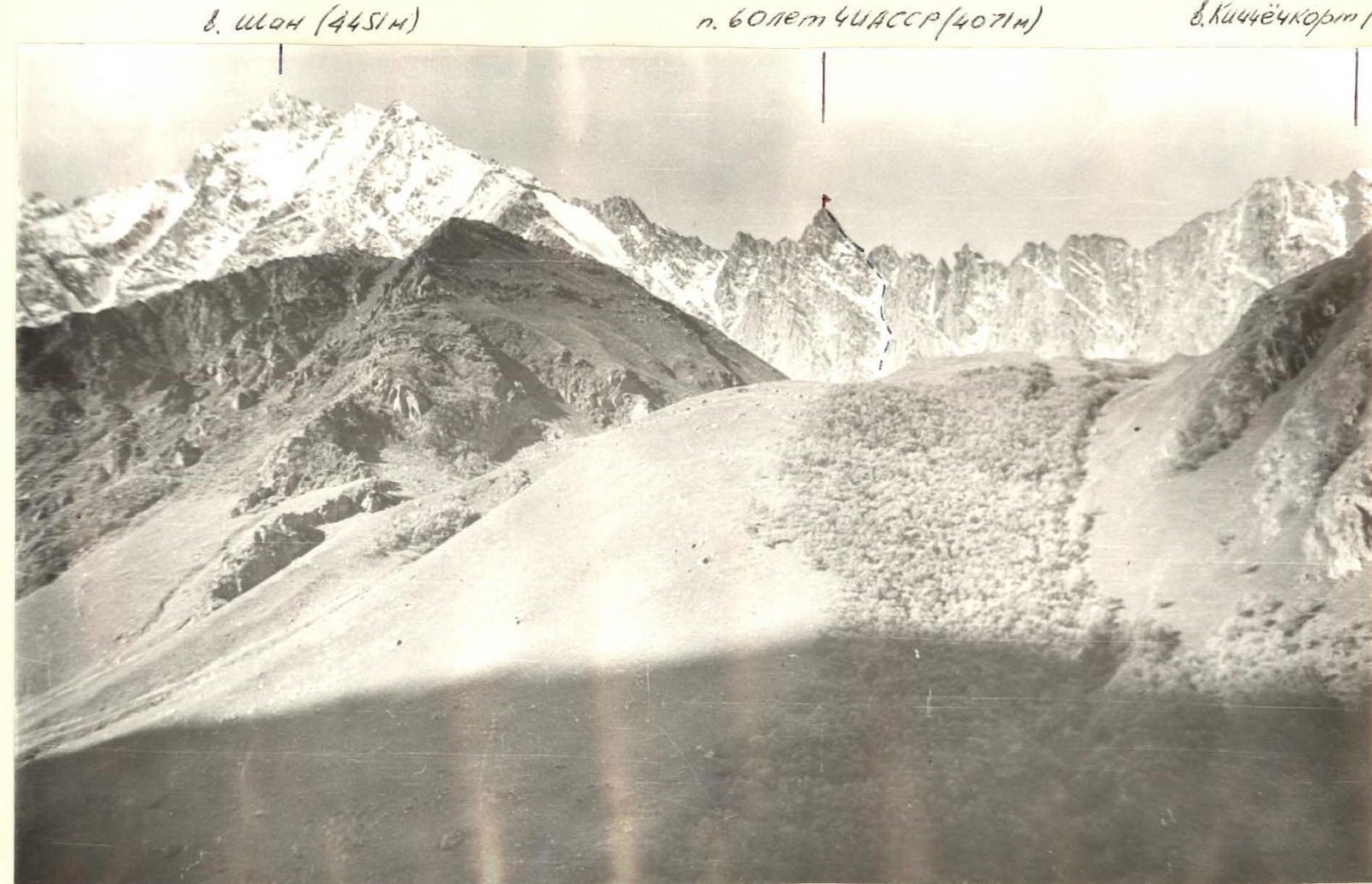
PHOTO PANORAMA OF THE ASCENT REGION
Description of the Ascent Region
The object of ascent — peak 60th anniversary of ChIASSR (peak 4071 m) — is located in the Eastern Caucasus, in the southern part of the Chechen-Ingush ASSR, in the Shavano ridge, on the border with the Georgian SSR.
Peak 60 years of ChIASSR is located in the center of the Shavano ridge, which separates the gorges of the Kistinka and Armkhi rivers. This ridge includes peaks:
- Shan (4451 m),
- Dzeneladze (4400 m),
- Rustavi (4350 m),
- Kichchochcort (4133 m),
- and others.
The peaks of this ridge have routes of 1st to 4th difficulty categories on the southern side, from Georgia. No ascents had been made from the ChIASSR side before.
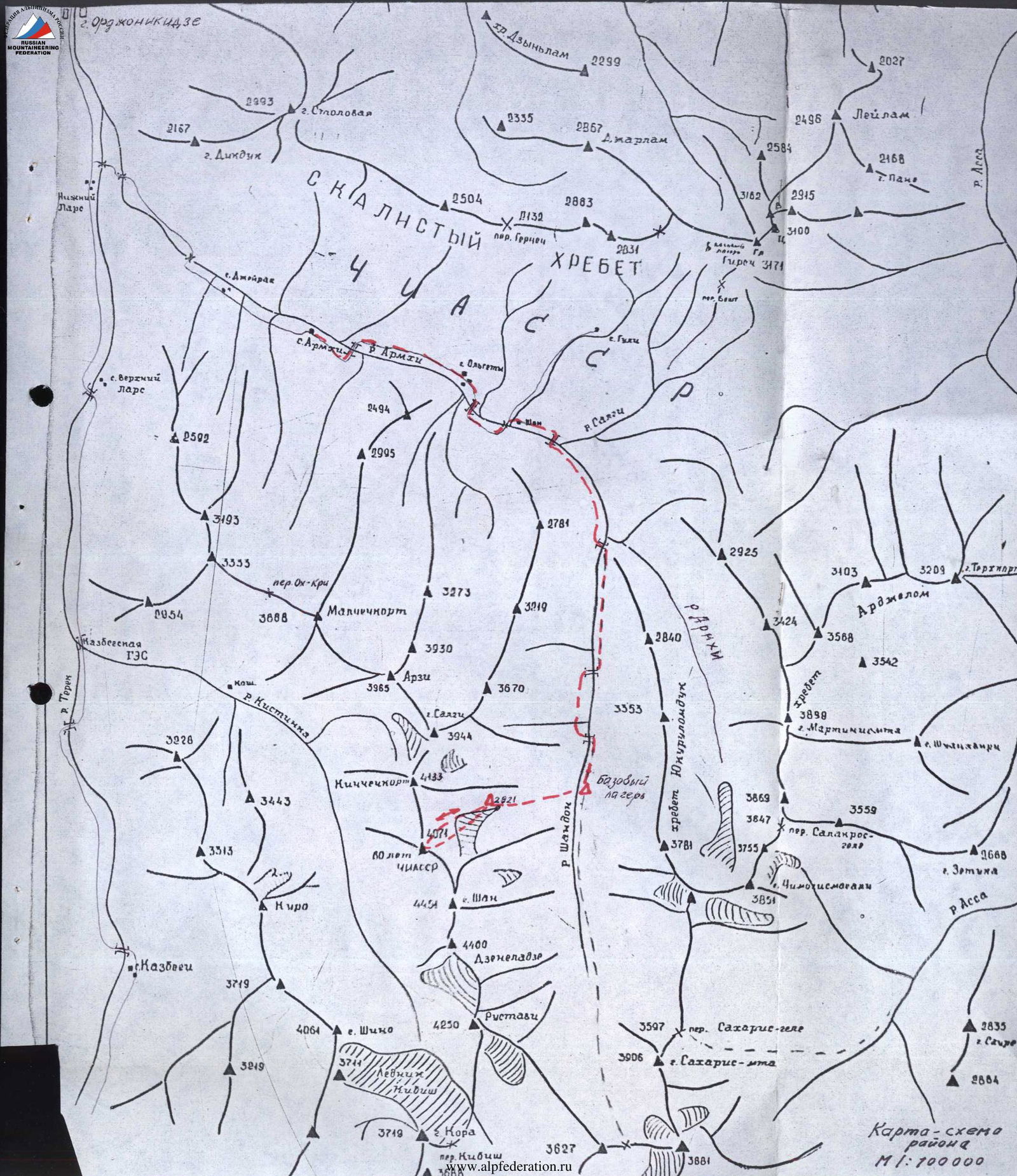
At the 21st km of the Military Georgian Road, the river Terek is joined by its left tributary, the Armkhi river. The road leads to the "Armkhi" sanatorium (12 km), which is accessible by regular buses from Ordzhonikidze.
From the "Armkhi" sanatorium, one can drive along the road to the turn into the Guli river gorge. Then, crossing the bridge over the Armkhi river, follow a good pack trail to the left tributary of the Armkhi river — the Shandon river (height 1800 m). The Shandon river flows strictly north and originates at a height of about 3000 m from under the scree on the northern slope of the Samtrekhlogosgele pass (about 3300 m, 1B category), through which one can reach the Chaucha massif.
The Shandon river gorge is rocky and grassy in its upper half, and below 2400 m is covered with forest.
Climb up the Shandon river gorge above the forest zone and set up a base camp near moraine lakes. It takes 5–6 hours to walk from the "Armkhi" sanatorium to the base camp.
From the base camp, cross the Shandon river and move west, up a steep slope with birch trees in the lower part and alpine meadows, to a moraine under peak 60 years of ChIASSR, where to set up a bivouac by a lake at a height of 2821 m.
Description of the ascent to peak 60 years of ChIASSR (peak 4071 m) via the right couloir of the NE wall — 3B category.
From the bivouac by the lake, the ascent route takes 50 minutes. There are places for overnight stays 20–25 minutes from the bivouac. Ascend via a wide scree couloir with a steepness of 25–35° to "red" stones in the couloir (20–25 minutes). Then, continue up the scree with large "red" stones to a 30-degree snowfield. Rope up! The couloir is prone to rockfall!
Stay on the right side of the couloir above the snowfield, on easy (20–30°) rocks, then on small scree, ascend 160 m up to where the couloir divides. Take the left couloir, which is up to 15 m wide (crampons, 120 m up, pitons) to a large stone. The stone has a control cairn. Bypass the stone on the right and ascend a 45–50° snow-ice slope (belay using ice pitons and ice axe) 160 m up to where the couloir divides again. Turn left and ascend a 45–50° snow-ice slope (belay!) 200 m up to a subtle right turn in the couloir. Continue in the left main couloir, on its right side (pitons), ascending 240 m to a ridge. From the ridge, ascend 160 m along moderately difficult, destroyed rocks and a ridge with a steepness of 24–35° left to a rocky bastion. Ascend the rocky bastion with a steepness of 35–45° (pitons!, belay!) to the summit — 60 years of ChIASSR.
From the bivouac by the lake to the summit — 10–12 hours. Descent from the summit via the ascent route — 5–6 hours.
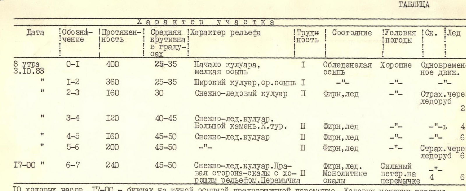
| Date | Section | Length | Average steepness | Terrain characteristics | Diff. cat. | Condition | Weather conditions | Rock | Ice |
|---|---|---|---|---|---|---|---|---|---|
| October 8, 1984 (8:00) | R0–R1 | 400 m | 25–35° | Beginning of couloir, small scree | 1 | Icy scree | Good | ||
| R1–R2 | 360 m | 25–35° | Wide couloir, medium scree | 1 | |||||
| R2–R3 | 160 m | 30° | Snow-ice couloir | 2 | Firn, ice | 2 | |||
| R3–R4 | 120 m | 40–45° | Snow-ice couloir. Large stone. Control cairn. | 3 | Firn, ice | 4 | |||
| R4–R5 | 160 m | 45–50° | Snow-ice couloir | 3 | Firn, ice | 6 | |||
| R5–R6 | 200 m | 45–50° | Snow-ice couloir | 3 | Firn, ice | 6 | |||
| October 8, 1984 (17:00) | R6–R7 | 240 m | 45–50° | Snow-ice couloir. Right side — rocks with good relief. Ridge | 3 | Firn, ice. Monolithic rocks | Strong wind on the ridge | 4 | 6 |
| Note: 10 travel hours. 17:00 — bivouac on the southern scree pre-summit ridge. Overnight stay conditions are good. | |||||||||
| October 9, 1984 (7:00) | R7–R8 | 160 m | 25–30° | Wide scree ridge with outcrops of moderately difficult rocks | 2 | Destroyed rocks | Strong wind | ||
| R8–R9 | 160 m | 35–45° | Pre-summit bastion. Rocks of moderate difficulty | 3 | Destroyed rocks | 2 | |||
| Note: Total travel hours to the summit — 12 hours. Descent via the ascent route 6 hours. |
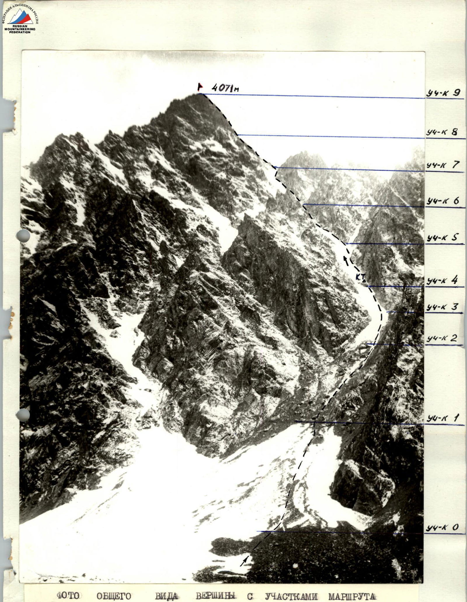
PHOTO OF THE SUMMIT WITH ROUTE SECTIONS