
Ministry of Sports of Krasnoyarsk Krai
KRASNOYARSK KRAI ALPINISM FEDERATION
Remote Championship of Russia in Alpinism
2018
Snow and Ice Class
Report
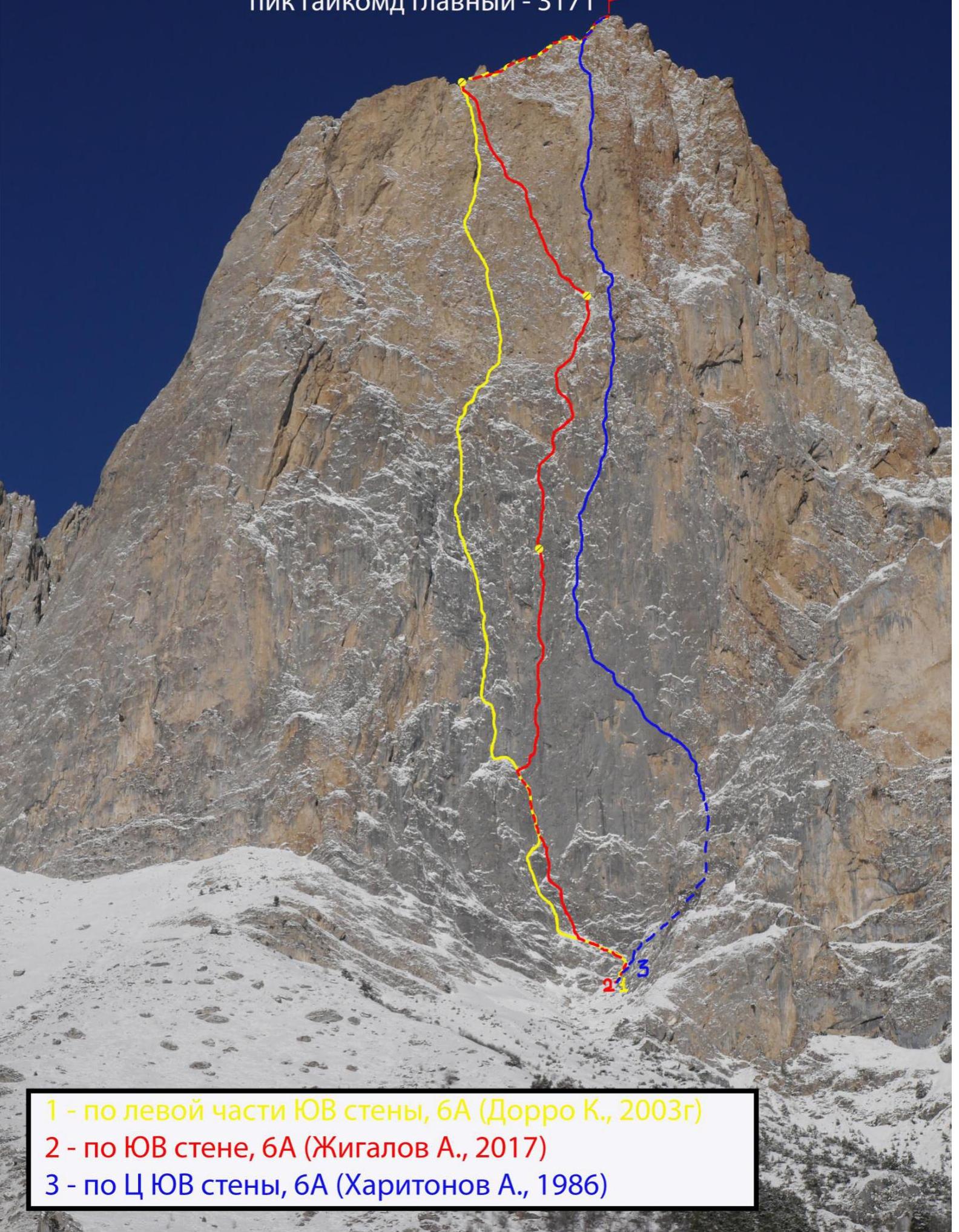
On the second ascent of the Krasnoyarsk Krai team - 3 to the peak Gaikomd Glavny, 3171 m, via the SE wall on Zhigalov's route, 6A category of complexity.
Team Leader: Evgeny S. Korulin
Participants:
- Alexander V. Verbitsky
- Stanislav Yu. Katanaev
Coaches:
- Nikolai N. Zakharov
- Valery V. Balezin
Ascent Passport
- Region – from Krestovy Pass to Shaviklde peak, p. 2.9
- Peak – Gaikomd Glavny, 3171 m, via SE wall
- Zhigalov's route, 6A category of complexity
- Route characteristic – rock
- Route description:
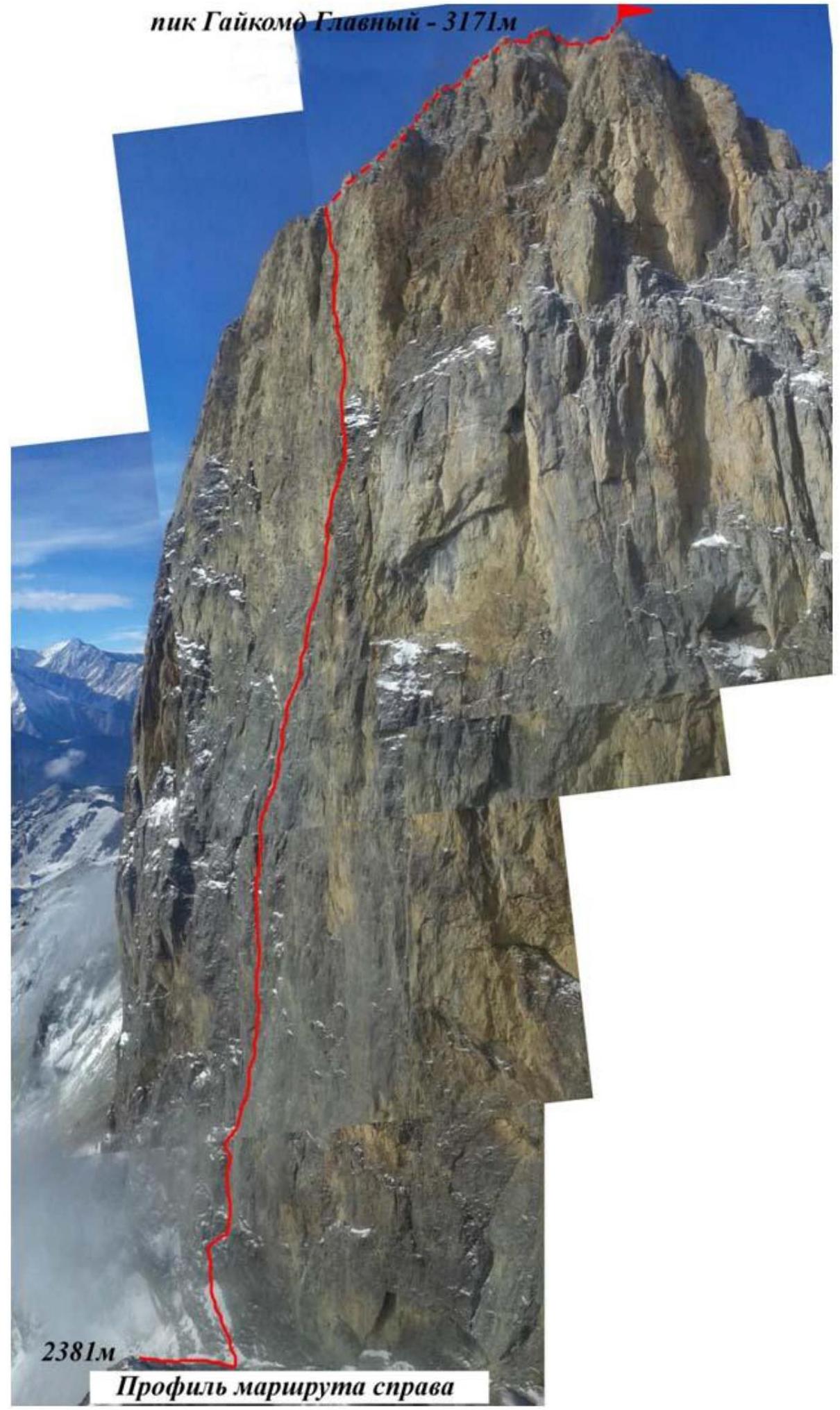
Height difference – 790 m, total route length – 1260 m. Wall section height difference – 680 m, wall section length – 865 m. Section lengths:
- 5 cat. of complexity – 365 m
- 6 cat. of complexity – 500 m
- A2 – 180 m
- A3 – 170 m
- A4 – 40 m
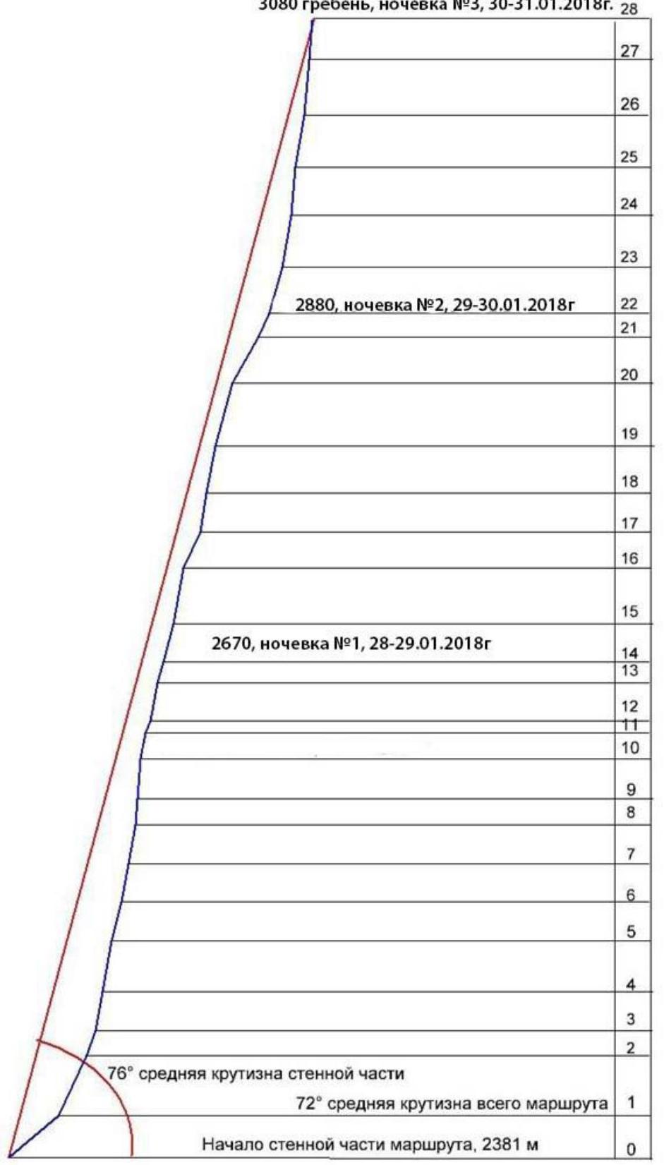
Average steepness of the wall section – 76°.
- Equipment used on the route: anchor pins – 150/92, camalots – 117/67, over 100 protection points on "fifths", 3 protection points on skyhooks, 8 drill-in bolts. Of these, 1 piece as a belay point, 4 pieces on stations with poor relief, 3 pieces on stations for platform installation.
- Total climbing time – 30 h 21 min, days – 4. Descent took 3 h via a route of 2A category of complexity.
Number of bivouacs – 3, all on platforms: 2 on the wall, one on the ridge.
- Team Leader: Evgeny S. Korulin, Candidate Master of Sports
Participants:
- Alexander V. Verbitsky, Master of Sports
- Stanislav Yu. Katanaev, Candidate Master of Sports
- Team Coaches:
- Valery V. Balezin, Master of Sports of International Class, Honored Coach of Russia
- Nikolai N. Zakharov, Master of Sports of International Class, Honored Coach of Russia
- Departure date:
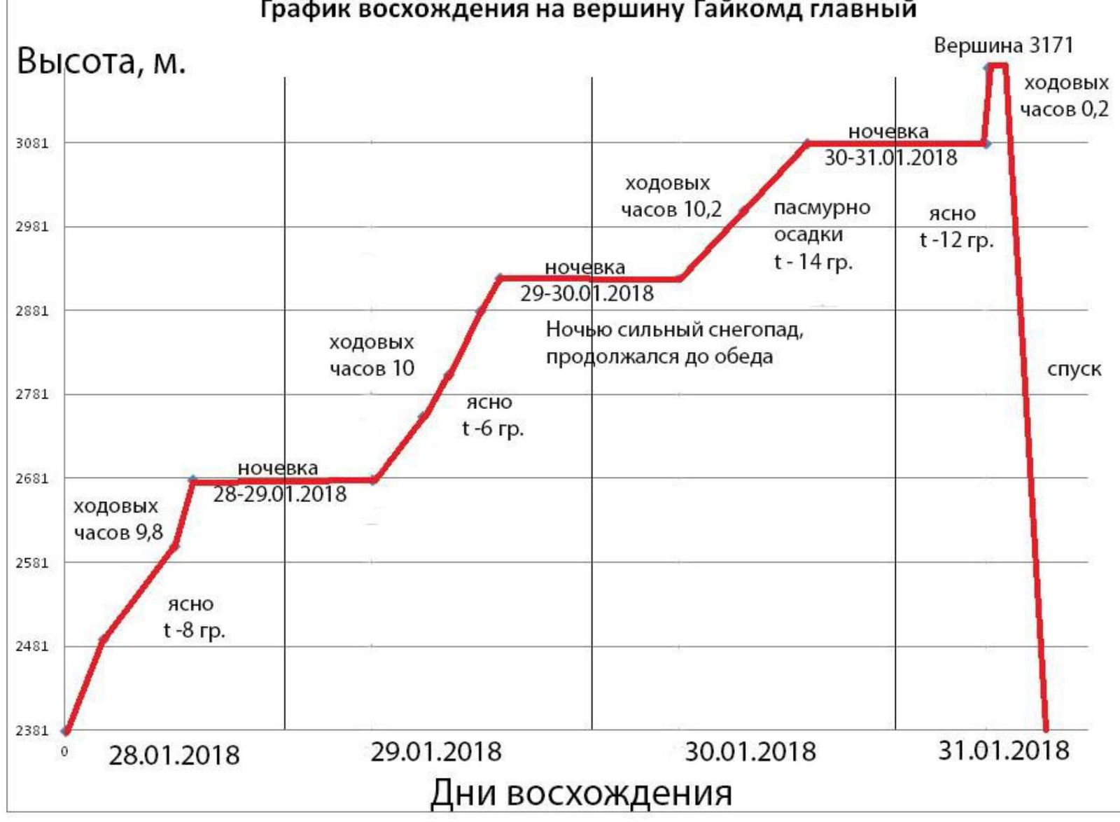
On the route – at 7:18 on January 28, 2018. On the summit – at 7:10 on January 31, 2018. Return to Base Camp – at 16:30 on January 31, 2018.
- Person responsible for the report: Evgeny S. Korulin, phone: 8 923 367-25-42
Email: Turitas34@mail.ru
- Ascent organized by – Ministry of Sports of Krasnoyarsk Krai.
Gaikomd Glavny peak – 3171 m.
 2381 m. Gaikomd Glavny peak 3171 m. January 31, 2018 at 7:10, 3080 m ridge, bivouac #3, January 30–31, 2018.
 Profile of the route.
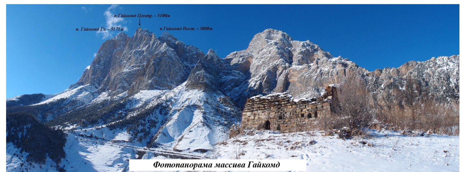 Panorama of the area.
Overview of the Ascent Area
The Gaikomd peak massif is located in the Skalisty Range of the Greater Caucasus, in the section of the range between the Terek River (to the west) and the Assa River (to the east). Gaikomd Glavny peak is the highest peak in the massif, towering above the Central and Eastern peaks. Previously, the peak was known as "Girech" in the classifier. The administrative border between the Republic of Ingushetia and North Ossetia – Alania runs along the crest of the Skalisty Range to Gaikomd peak, then it goes north. The ascent route and approaches are located on the territory of the Dzheyrakhsky district of the Republic of Ingushetia.
No border permits are required for the Gaikomd peaks area, but it is necessary to notify the outpost of your presence in the area.
The approach to the route takes about 1 hour. Move in the direction of the southern walls of Gaikomd Glavny peak along the grassy ridge, 300 meters before the wall, on the flattening of the ridge, above the forest level, turn right and approach the beginning of the couloir between Gaikomd Glavny and Gaikomd Central peaks. Up the couloir about 50 m, here is the start of the route:
- to the left is a small wall with an exit to a ledge.
Tactical Actions of the Team
In January 2018, the Krasnoyarsk Krai team, as part of the Russian Championship in the ice-snow class, made a second ascent of Zhigalov's route on Gaikomd Glavny peak via the SE wall, 6A category of complexity. The line runs between the routes:
- 6A category of complexity, Dorro K., 2003
- 6A category of complexity, Kharitonov A., 1986
On January 28, 2018, the Krasnoyarsk-3 team, consisting of Korulin E.S., Verbitsky A.V., Katanaev S.Yu., left the base camp. At 6:00, they approached the start of the route, packed their bags with gear, food, gas, and 10 liters of water, and one bag with a rolled-up platform. At 7:18, they began work on the route. At 10:00, they reached the "Oгурец" (Cucumber), station R5. At 15:30, the first climber passed the R10 section, the site of the first bivouac of the first ascenders. At 17:00, the leader processed 10 m from the R14 ledge, above which they organized a bivouac on a platform.
On January 29, 2018, at 7:00, the first climber started work on the route. At 11:00, they reached station R17. At 13:00, they passed the R19–R20 section. At 15:30, they climbed to the ledge at station R22. They left gear for a bivouac and continued processing until R23. The second bivouac coincided with that of the first ascenders.
On the night of January 30, 2018, the weather deteriorated, and heavy snowfall began, continuing until the afternoon of the next day. The key sections of the route, described as A4, became very difficult due to the large amount of precipitation, creating a high risk of falling with a deep drop. The pace slowed down three times from the expected. The wall became steeper and more destroyed. It was only at 17:12 that they managed to reach the ridge, where they organized a third (unplanned) bivouac.
On January 31, at 7:10, the team reached the summit of Gaikomd Glavny – 3171 m. The descent took about 3 hours via a route of 2A category of complexity. After the snowfall, the descent was characterized by increased avalanche danger.
The route was climbed without prior processing, in alpine style. All bivouacs were organized on the wall, suspended, using a collapsible platform. Each day, the platform was moved to the next bivouac site. During the ascent, a partially simultaneous movement scheme was used, significantly increasing the speed of the ascent.
The route proved to be quite complex and labor-intensive. The overall angle of the wall is very high, about 76°. There are many sections of difficult climbing, both psychologically and physically:
- VI climbing – 500 m
- V climbing – 365 m
- A4 – 60 m
- A3 – 170 m
Many belay points were unreliable: anchor pins driven into blind cracks or into earthy, grassy tufts. It was necessary to spend a lot of time and effort cleaning the relief to organize reliable belay points and to pass through it. The upper part features AID climbing on crumbling cornices and "singing" slabs.
Ascent graph to Gaikomd Glavny peak.
Technical profile of the route.
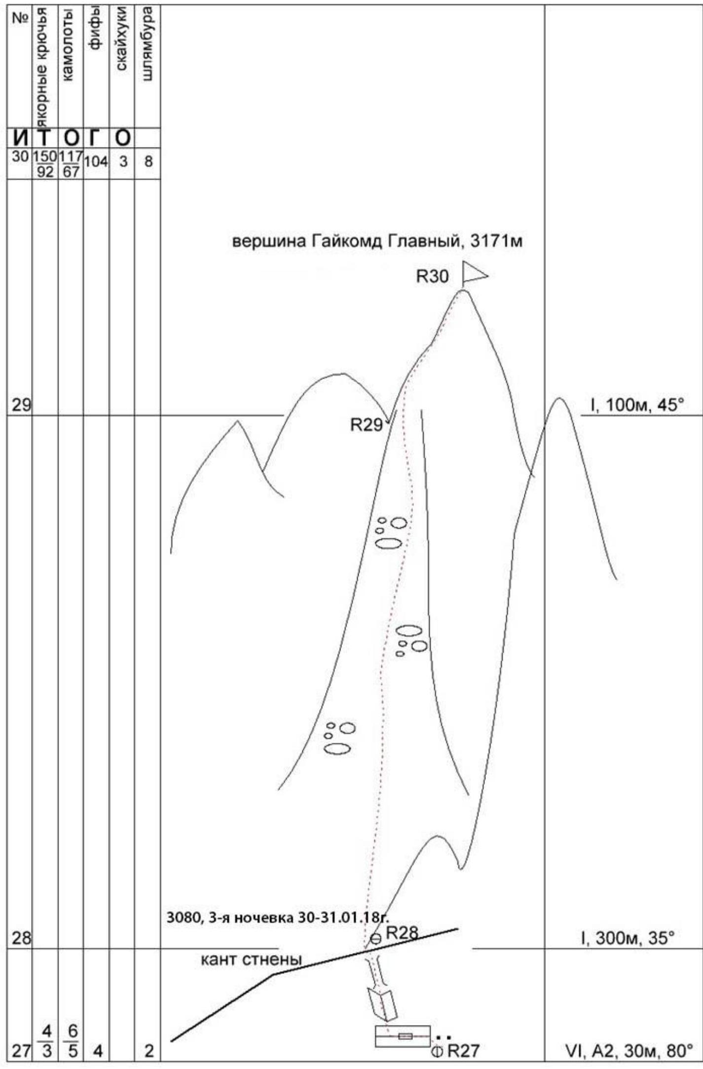 R28 – 3080 m, third bivouac January 30–31, 2018.
Section-by-Section Description
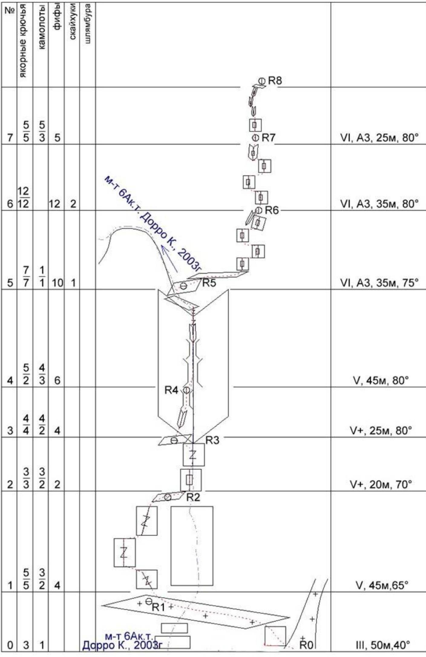
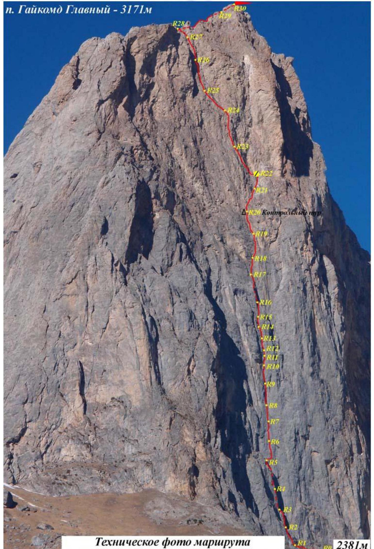
R0–R1. Start of the route from the snow couloir. 50 m, 40 min, III.
- Up left, a wall about 7 m, exit to a large ledge with snow.
- Traverse left along the ledge about 40 m.
- Station on the right on the wall on anchors. There is one drill-in bolt (driven during the descent from Dorro's route – 2003).
R1–R2. 50 m, 50', V. From the station, up left along the wall with cracks and grass. First, left into a vaguely expressed inner corner, then straight up, then right along an inclined ledge with cracks. Here the route joins Dorro's route, 6A category of complexity – 2003, and continues for about 80 m. Station on a small ledge, shared, several pins blocked with a piece of rope.
R2–R3. 20 m, 70' V+. Up along the steep wall with rich relief, many cracks and fissures. Exit to a flattening, station on a ledge at the base of a huge inner corner with a chimney inside.
R3–R4. 25 m, 80' V+. Up along the left wall of the inner corner, then along the expanding chimney. Exit to another rappel station. Station is hanging, in the chimney on rock pins and channels, blocked with a piece of rope.
R4–R5. 45 m, 80' V+. Up the chimney, then the chimney turns into an inner corner, the relief flattens. Further, through a series of small walls and ledges, exit to a ledge, not reaching about 10 m to the top of the bastion (to station R4 on Dor-Rescue), organize a station on the right on the wall, near a short ledge, turning right for 5 m.
R5–R6. From this point, the routes diverge. 35 m, 75' VI, A3. Start of the first crux. To the right of the station along a narrow short ledge about 5 m. Then up, slightly right, along a smooth, vertical wall. On cavities, shells, and small cracks on "fifths" and skyhooks. Insurance only on anchors, sometimes driven in with just the tip, sometimes in horizontal cracks. One step on a "hole" skyhook D=6 mm. Station is hanging in a short inner corner.
R6–R7. 35 m, 80' VI, A3. Further up, the guideline is grass tufts at the top, to the left of a large black streak. The angle of the wall increases, there is less relief. You have to move left and right and back in search of shells and cracks. Also on "fifths", anchors, and skyhooks.
- Sometimes "fifths" are placed on the relief.
- 2 steps on "hole" skyhooks.
Station is hanging on anchors.
R7–R8. 25 m, 80° VI, A3.
- Up along the smooth wall.
- Further along the crack.
- Then a wall bend – the beginning of an inner corner with a crack.
- Up the corner.
- Exit to a small grassy ledge.
- Hanging station on anchors.
R8–R9. 20 m, 85' VI, A3. Up the logical corner through a crack. Station is hanging.
R9–R10. 30 m, 85' VI, A3. Up the wall, entry into an inner corner. Along the corner, slightly up right, exit to a grassy tuft on the wall. Station on anchors, relief is rich. To the right of the tuft is a bolt without an eye, used by the first ascenders to install a platform.
R10–R11. 15 m, 80' VI, A3. From the station up right along the wall, bypassing the overhanging part of the large corner on the right. Through a vertical chimney in the inner corner, exit to small tufts in the corner. Semi-hanging station.
R11–R12. 10 m, 65' V+, A2. Small flattening, along the wall up left, entry into a small chimney. From the chimney, exit into an inner corner with a wide right wall. Station on own points and on a bolt.
R12–R13. 30 m, 80' VI, A2. From the station up along logical wide fissures overgrown with grass tufts. Exit to a small convenient ledge. Semi-hanging station.
R13–R14. 15 m, 75' VI, A2. From the ledge up along a narrow chimney, then through a wall, exit to a good ledge. If necessary, a sitting bivouac for 3–4 people can be organized on the ledge. Station is convenient, on the ledge. Bivouac on a platform.
R14–R15. 30 m, 75' VI, A2. From the ledge up right along cracks and fissures in the direction of the rib on the right. Exit beyond the rib, hanging station on the border of the bend.
R15–R16. 45 m, 80' VI, A2. From the rib straight up into a large inner corner, inside which, along fissures and chimneys, a logical exit up left onto a bastion. Semi-hanging station at the top of the bastion ("Cucumber").
R16–R17. 30 m, 65', V. From the bastion up right, "coil climbing" on friction through "ram's foreheads", then along cracks, exit to a ledge. Convenient station.
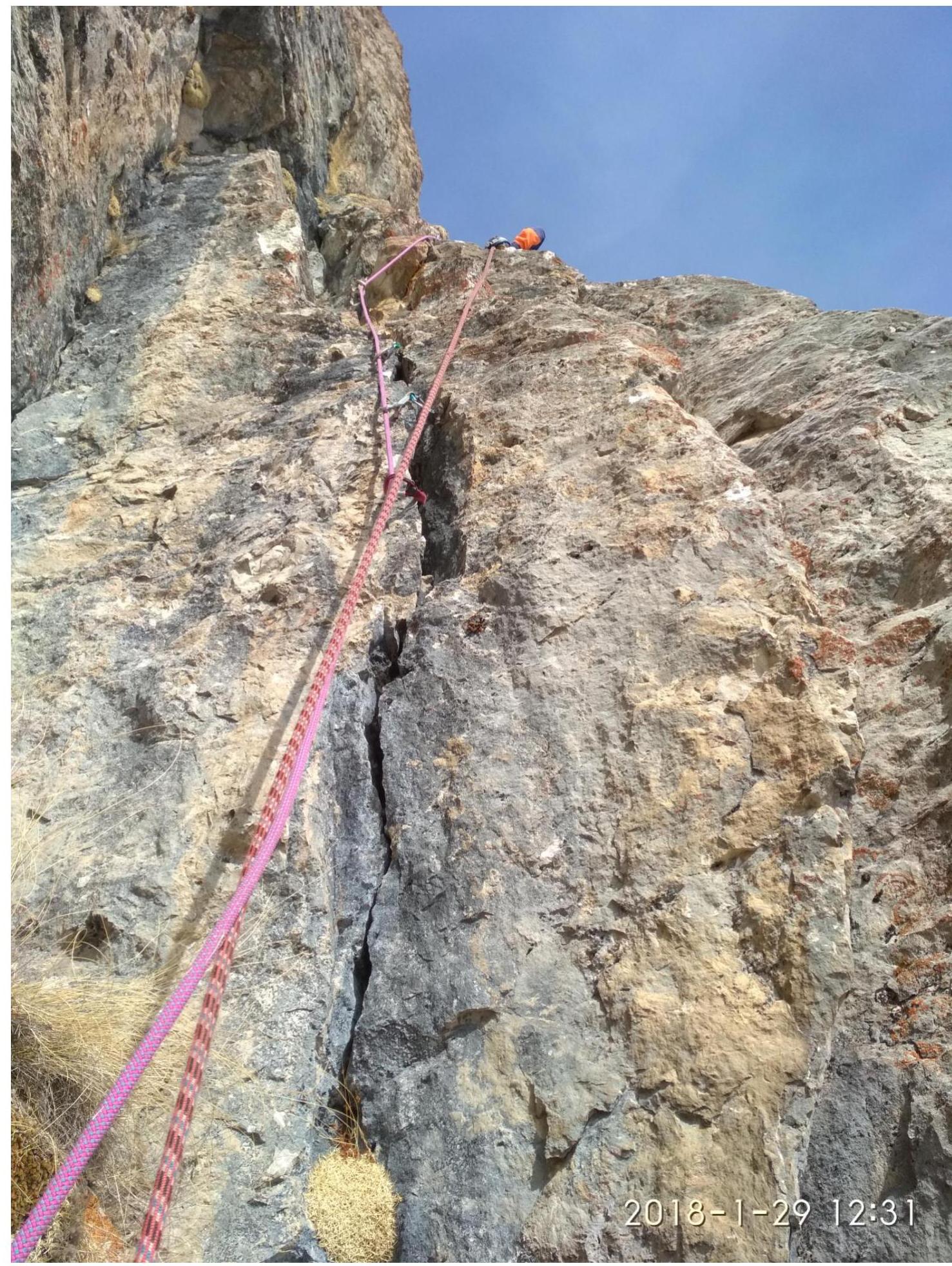
R17–R18. 30 m, 80' VI, A2. Along the ledge, traverse right to a vertical wall. Up the wall. Sometimes the relief is very destroyed, everything falls down on the belayer. Exit to a small ledge, convenient station.
R18–R19. 35 m, 80' VI, A2. From the ledge, slightly more to the right, up along a vertical wall with two parallel cracks. Exit to a flattening, along:
- grassy ridges
- scree Exit to a good ledge under a rusty overhanging wall. Convenient station on the ledge.
R19–R20. 50 m, 75' V+, A2. From the station along the rusty wall:
- first left up,
- then straight and then right up along very destroyed relief, traversing right up,
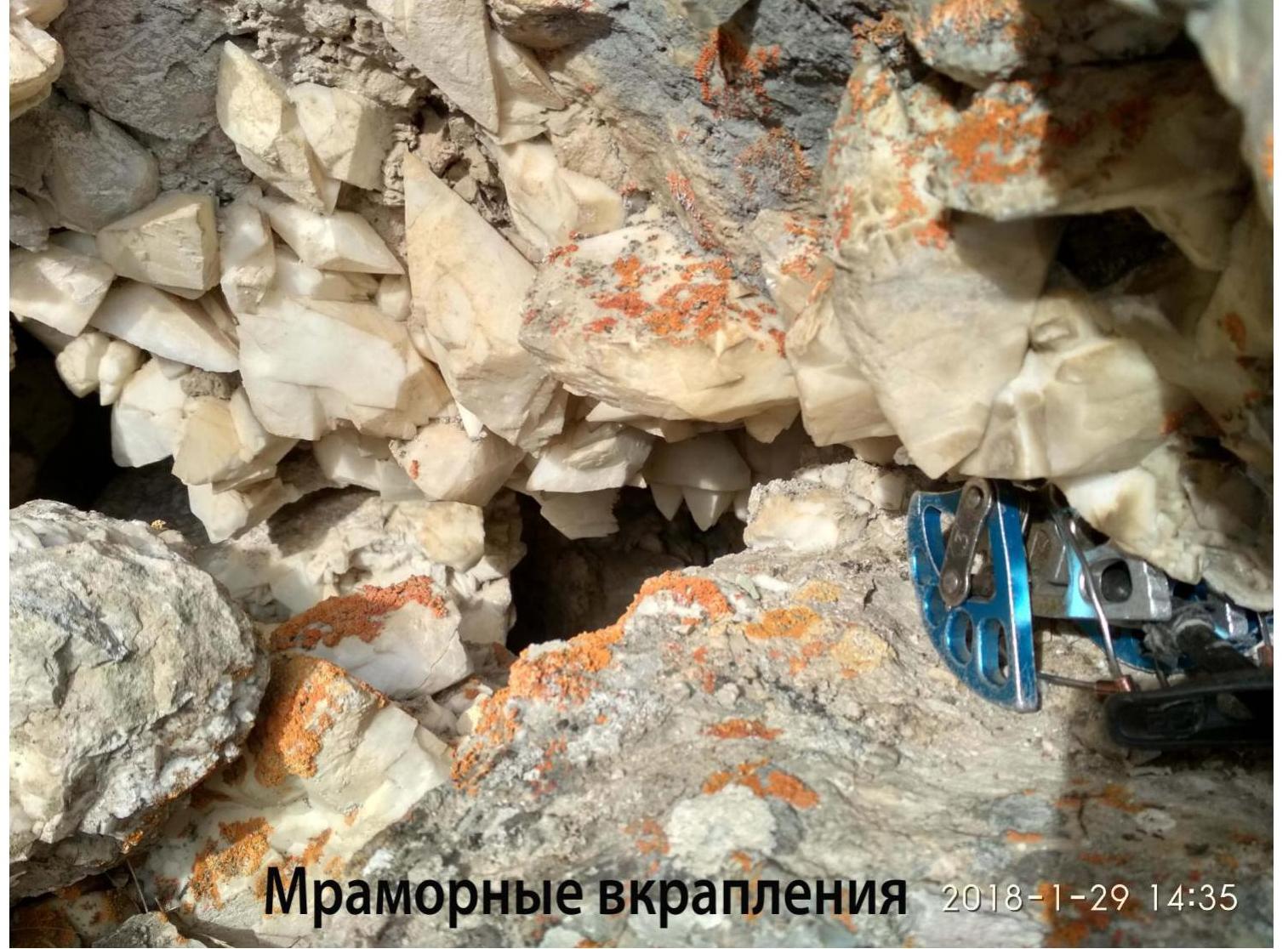
- exit to a ledge to a large accumulation of marble boulders of bizarre shapes, with large crystalline inclusions. Convenient station on the ledge. There is also a control cairn made of a plastic bottle in a grotto.
R20–R21. 40 m, 60' V+. From the station up, to the left of the marble accumulation, climbing along cracks and fissures to an inner corner, then along the corner, exit to a small ledge. Convenient station.
R21–R22. 20 m, 65' V. Up right along the wall, entry into a scree couloir with "ram's foreheads", exit from the couloir through a small wall left, exit to a large sloping ledge. Along the ledge, a bit left. Station near a grotto. Above left of the grotto, two bolts are driven for hanging a platform, with an eye twisted off on the right. This was the site of the second bivouac.
R22–R23. 35 m, 75' VI+, A3. Along the ledge, traverse left to the wall. Up left along the wall – difficult climbing and AID. Exit to a small ledge, semi-hanging station.
R23–R24. 40 m, 80' VI+, A3. From this point begins the 2nd crux section, and ends only on the ridge. From the station up, then traverse left around the rib. Along the rib straight up through a small wall to the station. The entire rock is conglomerate, making it difficult to organize reliable belay points. Station is hanging on a bolt and anchors.
R24–R25. 35 m, 85° VI, A3. From the station, traverse left about 5 m, then up along the wall, exit beyond the bend. Tense climbing, unreliable belay points. Beyond the bend, traverse left to a ledge. Station is convenient.
R25–R26. 40 m, 80' VI+, A4. From the ledge, slightly left and up along a vertical wall, through an inner corner turning into a chimney. Exit to a small ledge, traverse along the ledge left to a semi-hanging station. Unreliable rock, everything crumbles and falls down.
R26–R27. 45 m, 85' VI+, A4. From the station:
- up right,
- then left,
- then again up right along white, very destroyed rocks. Very tense climbing, extremely unreliable belay points. A bolt is driven in the gap for insurance. From the bolt, slightly left up to a hanging station on own points and two bolts.
R27–R28. 30 m, 85' VI, A3. From the station:
- traverse left to an inner corner,
- up the corner and through a chimney, exit to the ridge. Convenient station on the ridge on the right wall.
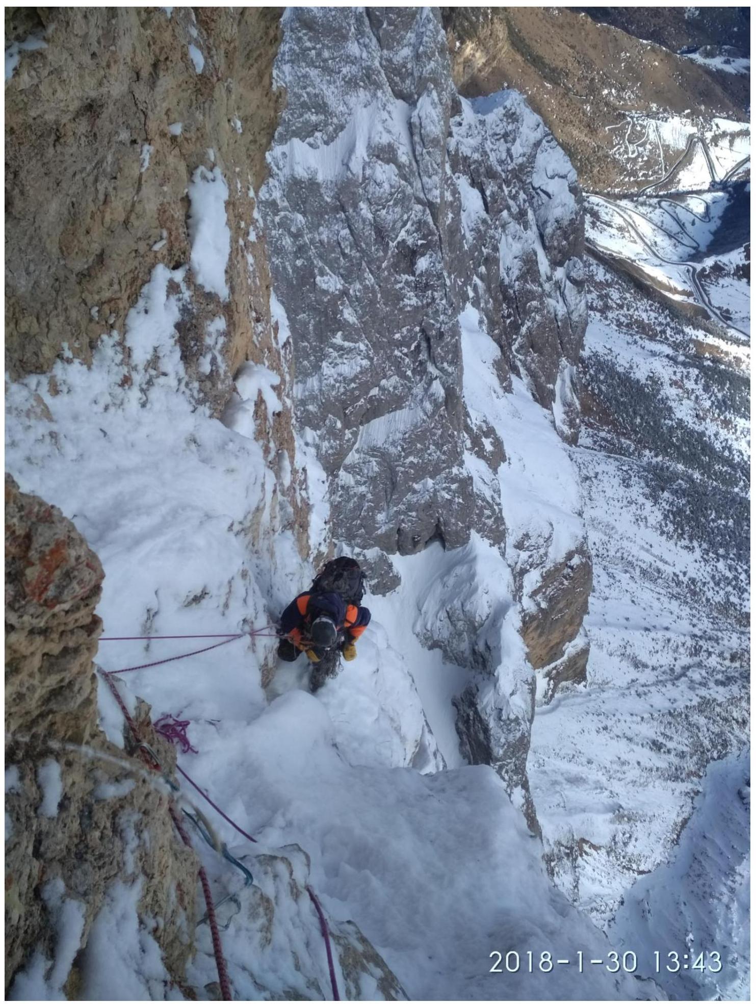
R28–R29. 300 m, 30' I. Up right through a rock step, then up along a simple scree slope in the direction of the summit.
R29–R30. 100 m, 45' I. Through accumulations of large stones, exit to the summit of Gaikomd Glavny – 3171 m.
Technical photo of the route.
We do not have a note from the summit. Since the ascent was made during the technical class Russian Championship, we handed over the note to the Championship Committee.
R18 section, Verbitsky A. is working.
Marble inclusions. R20 section.
Second bivouac R22.
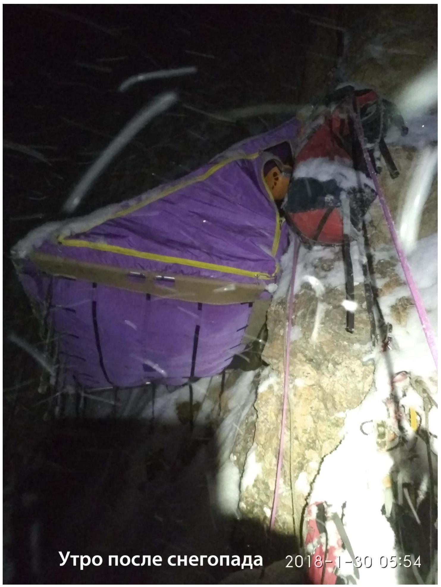
R25 section after a night snowfall.
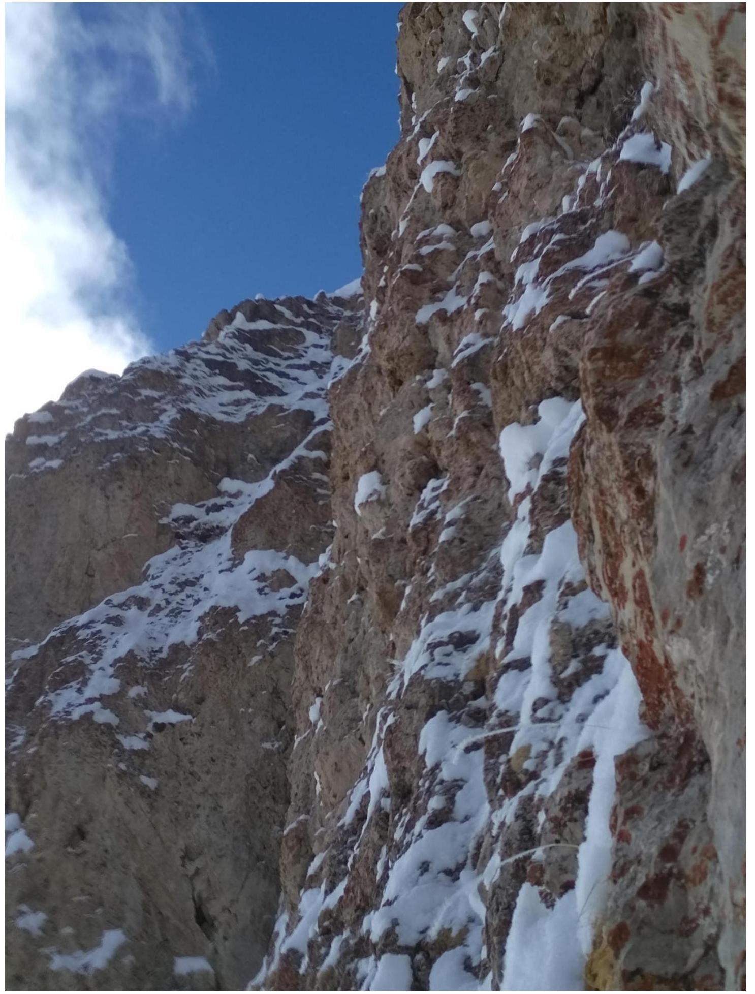
R26 section.
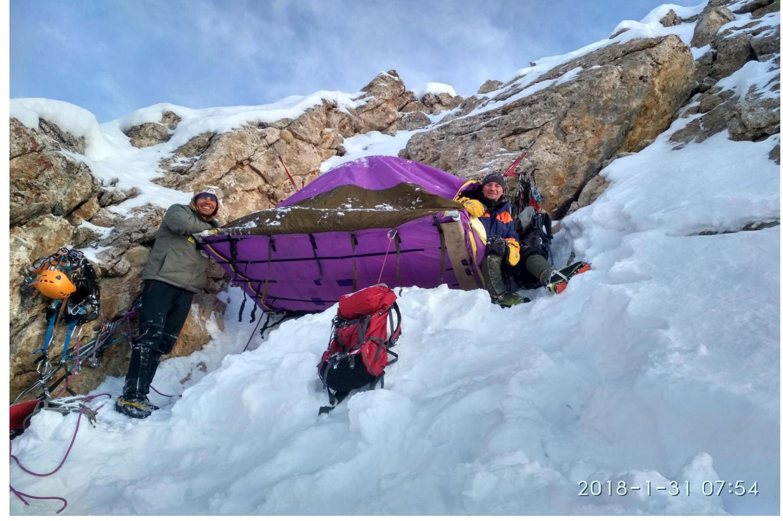
Third bivouac on the ridge.
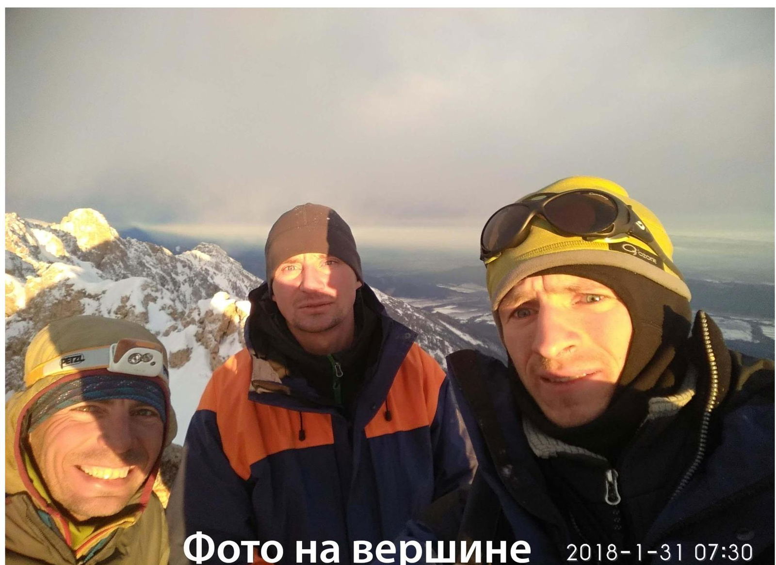
Summit Photos
January 31, 2018, 7:30.
Comments
Sign in to leave a comment