
Russian Championship in Alpinism
2017
Technical Class
Report
On the first ascent of the team from Krasnoyarsk Krai–1 to the summit of Gaikomd, 3171 m, via the SE wall. First ascent, approximately 6A category.
Team Leader: Zhigalov Alexander Vladimirovich
Team Members:
- Loginov Igor Alexandrovich
- Krivosheev Maxim Leonidovich
Coaches:
- Zakharov Nikolai Nikolaevich
- Balezine Valery Viktorovich
Report Contact: Zhigalov A.V., 0jog@bk.ru, +7-983-574-84-88
Ascent Details
-
Region — from Krestoviy Pass to Shaviklde peak, p.2.9
-
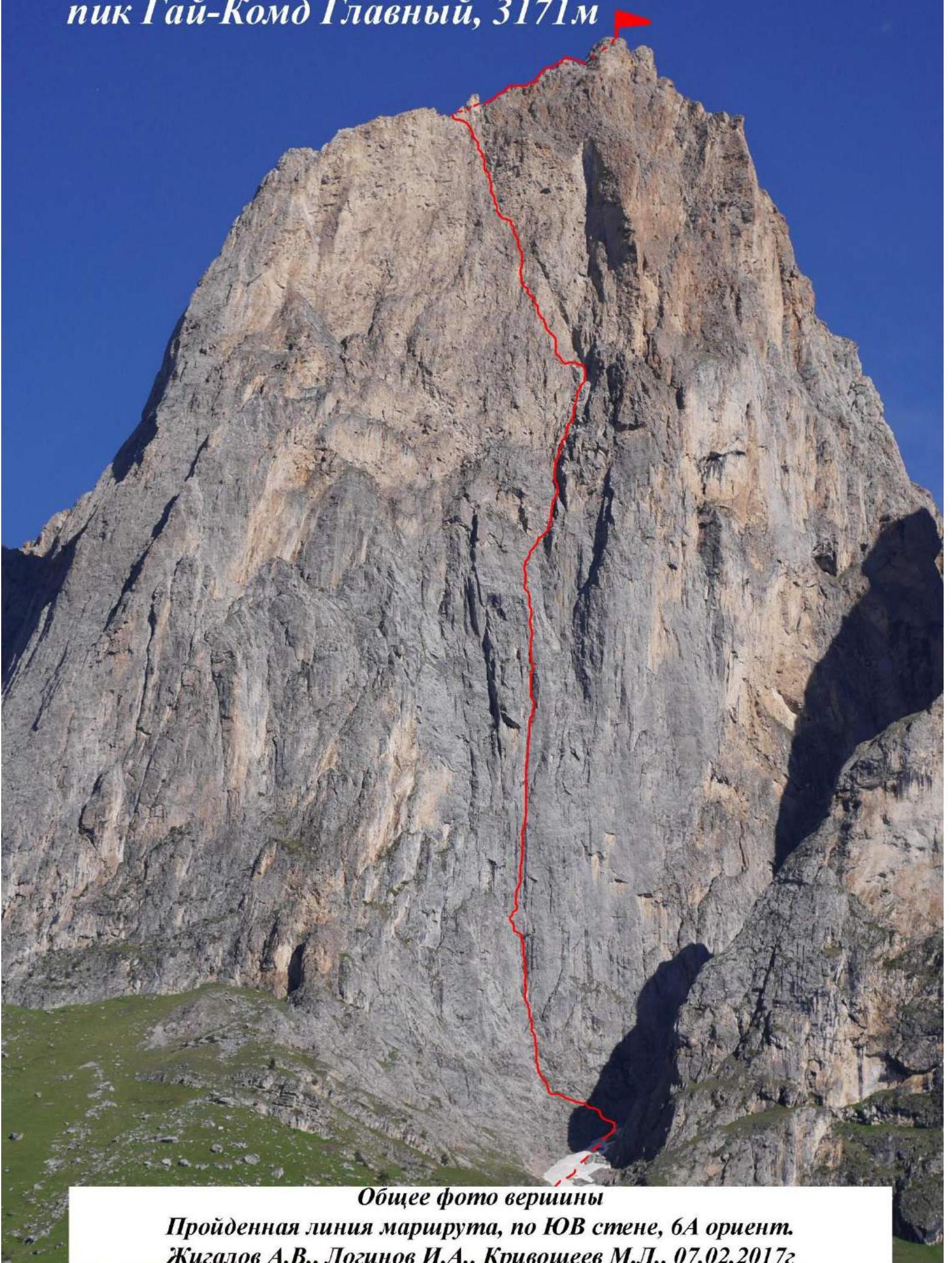
Summit — Gaikomd Main, 3171 m, via SE wall
-
Expected — 6A category — first ascent
-
Route Type — Rock climbing
-
Route Characteristics:
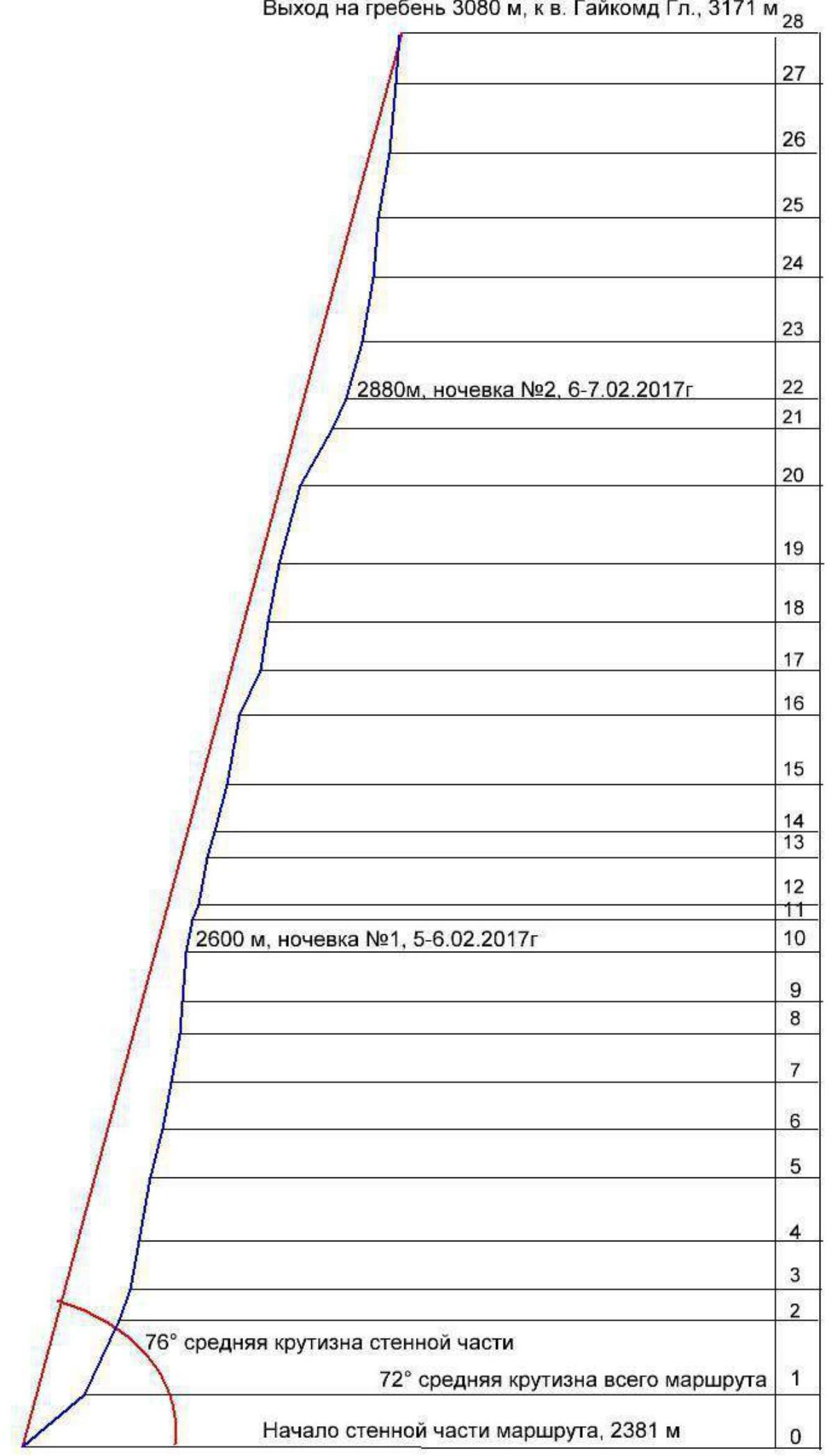
Route elevation gain — 790 m, total route length — 1305 m. Wall section elevation gain — 680 m, wall section length — 855 m. Section lengths:
- 5 category — 285 m,
- 6 category — 570 m, including:
- A2 ITO — 245 m,
- A3 ITO — 300 m,
- A4 ITO — 85 m. Average steepness of the entire route — 73°, wall section — 76°.
-
Equipment used on the route: anchor pitons — 150/92, camalots — 109/75, about 120 ITO on "fifis", 3 ITO steps on skyhooks, 8 bolt hangers hammered and left (1 as a belay point, 4 on stations with poor relief, 3 on stations for platform setup).
-
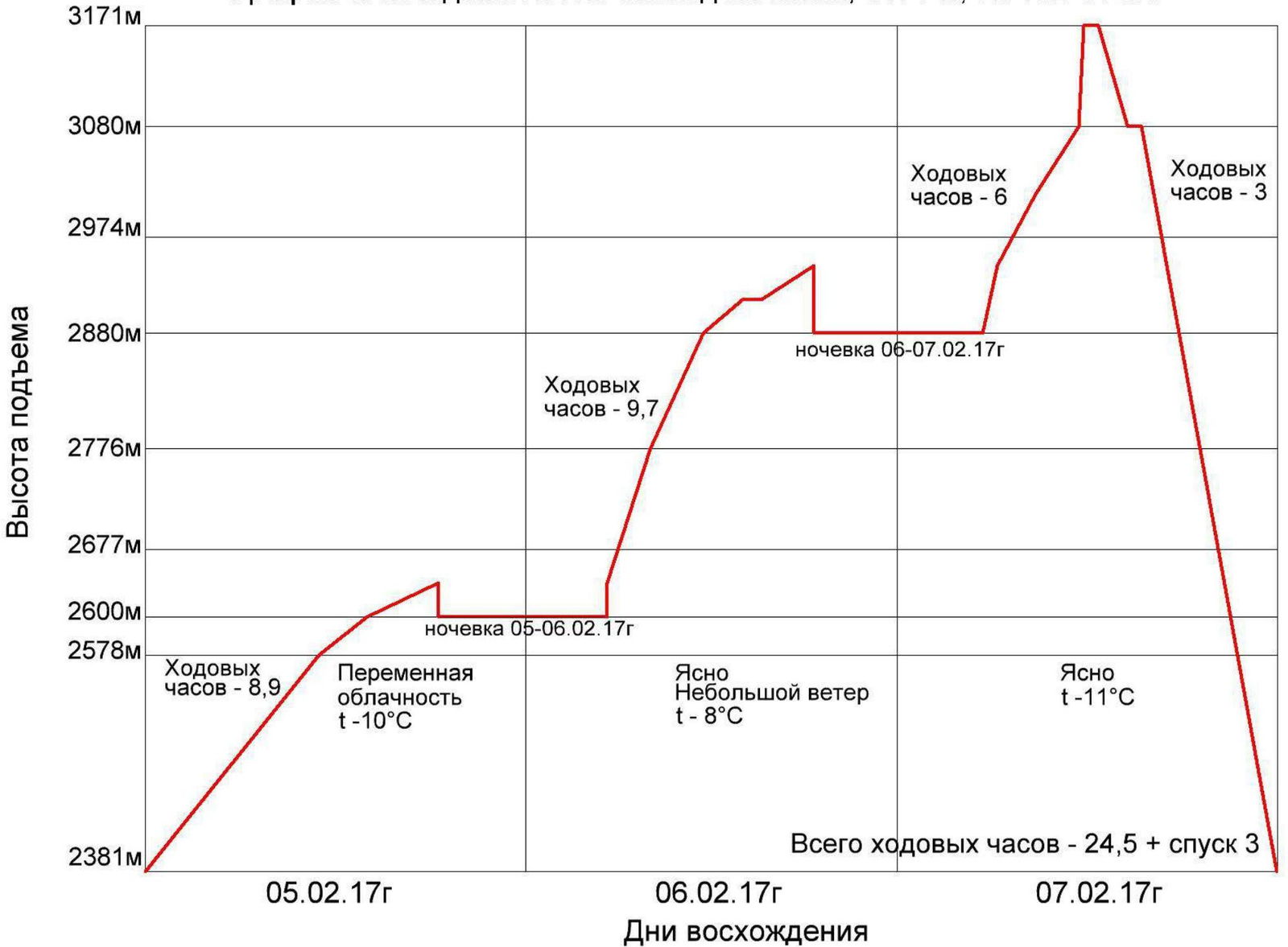
Climbing time — 24.5 hours, duration — 3 days. Descent via classical route, 1B category, took 3 hours.
Number of bivouacs — 2, both on platforms on the wall.
-
Team Leader: Zhigalov Alexander Vladimirovich, Master of Sports Team Members: Loginov Igor Alexandrovich, Master of Sports; Krivosheev Maxim Leonidovich, Master of Sports
-
Team Coaches:
Balezine Valery Viktorovich, Master of Sports International Class, Honored Coach Zakharov Nikolai Nikolaevich, Master of Sports International Class, Honored Coach
-
Departure Date:
On route — at 8:01, February 5, 2017 On summit — at 13:13, February 7, 2017 Return to Base Camp — at 16:30, February 7, 2017
-
Report Contact: Zhigalov Alexander Vladimirovich, phone: 8-983-574-84-88. Email: 0jog@bk.ru
-
Ascent organized by — Ministry of Sports of Krasnoyarsk Krai
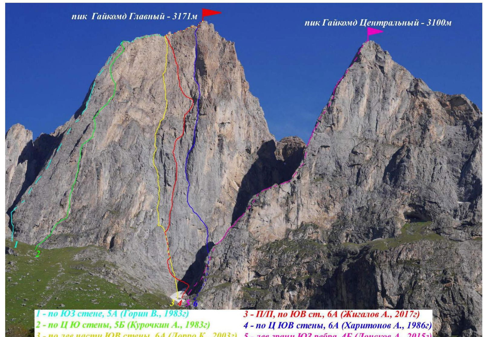
- 3 — First Ascent, SE wall, 6A (Zhigalov A., 2017)
- 4 — Central SE wall, 6A (Kharitonov A., 1986)
- 5 — Left edge of SW rib, 4B (Donskov A., 2015)
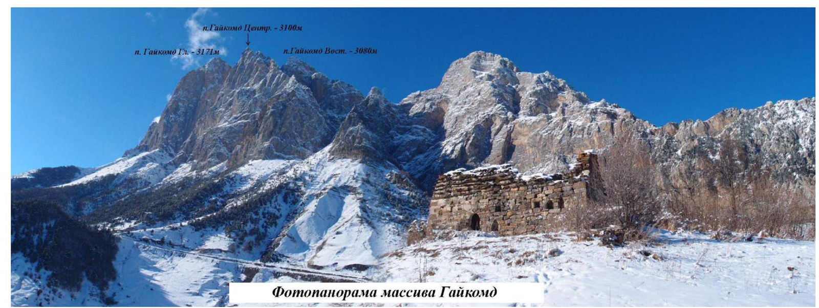
Gaikomd Main Peak, 3171 m
Gaikomd Main Peak — 3171 m
February 7, 2017
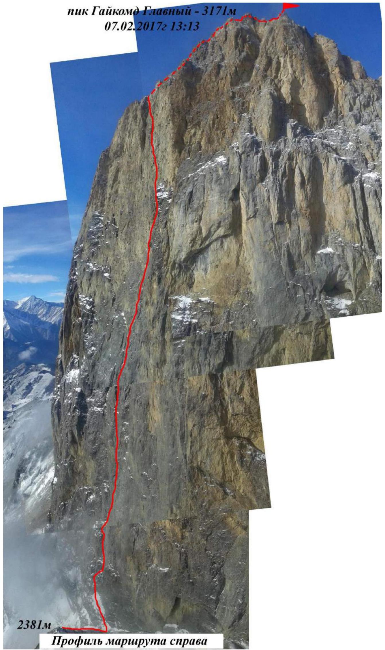
Reached the ridge at 3080 m, summit of Gaikomd Main, 3171 m, on February 7, 2017 at 13:13.
Area Photopanorama
Climbing Area Overview
The Gaikomd peak massif is located in the Skalisty Range of the Greater Caucasus, between the Terek River (to the west) and the Assa River (to the east). Gaikomd Main is the highest peak in the massif, rising above the Central and Eastern peaks. Previously, the peak was listed in the classifier under the name "Girech". The administrative border between the Republic of Ingushetia and North Ossetia–Alania runs along the ridge to Gaikomd peak and then heads north. The ascent route and approaches are located within the Dzheyrakhsky District of the Republic of Ingushetia.
It's advisable to set up the base camp near Besht Pass, 100 m before the turn to the "Besht" border post, on a clearing to the left of the road. Water is available year-round at the water intake. Other convenient options include:
- About 2 km along the road from the border post
- "Legends of the Mountains" hotel
- Base jumper camp
Border permits are not required for the Gaikomd peaks, but it's necessary to inform the border post of your presence.
Cell phone coverage is available through "Beeline" and "Megafon" networks, and "MTS" on the wall and at higher elevations, with mobile internet. Weather in the area is relatively stable, with snowfall periods lasting 2-3 days, and snow melts quickly on the routes. This should be considered for prolonged wall ascents. In winter, after heavy snowfalls, be cautious of couloirs and windward slopes due to potential avalanches.
The approach to the route takes about 1 hour. Follow the grassy ridge towards the southern walls of Gaikomd Main, then turn right onto a flattening ridge above the forest level and approach the start of the couloir between Gaikomd Main and Gaikomd Center. The route begins at a small wall with a ledge about 50 m up the couloir.
The Gaikomd ridge is composed of sedimentary limestone, partly metamorphosed. The first two-thirds of the wall:
- Is relatively monolithic, with a grey hue.
- Features various cracks, crevices, and cavities, similar to Crimean walls like Morcheka, Forosskiy Kant, and Sokol.
- Much of the relief is filled with earth, grass, and tufts, requiring time to clean for reliable anchor points, and fine grass dust can be a nuisance.
The upper third of the wall:
- Is steeper and more crumbling, with a white or yellow hue, reminiscent of Ak-Kaya and Kara-Kaya in Bezengi.
- The rock is fragile, with sections of soft chalk inclusions.
- Organizing reliable belay points is particularly challenging.
Special attention should be given to the reliability and placement of anchors.
Team Tactics
In February 2017, the Krasnoyarsk Krai–1 team completed a new route on Gaikomd Main peak via the SE wall as part of the Russian Championship in Alpinism, Technical Class. The line runs between the 6A category routes by Dorro K. (2003) and Kharitonov A. (1986).
On February 5, 2017, the Krasnoyarsk–1 team, consisting of Zhigalov A.V., Loginov I.A., and Krivosheev M.L., departed from the "Legends of the Mountains" hotel base camp at 5:10. They reached the start of the intended route at 6:30, set up their equipment, and began climbing at 8:01. By 11:00, they had climbed about 4 ropes to the "Ogurets" station (R5). By 14:00, they had completed about 3 key ropes on the smooth vertical wall to R8. At 17:00, the lead climber completed the R11–R12 section while the second and third climbers set up a platform on R10. Throughout the day, Zhigalov A.V. led, Loginov I.A. followed with a haul bag, and Krivosheev M.L. trailed, hauling the second bag and platform.
On February 6, 2017, they followed the fixed ropes to R12. The lead climber started at 7:10. By 11:00, they reached R17, and by 13:00, they completed the R19–R20 section. At R20, they left a water bottle cache and continued. By 15:00, they reached a ledge at R22. After a brief rest, they continued to R23. Loginov I.A. led throughout, followed by Zhigalov A.V., while Krivosheev M.L. set up a platform at R22. They left 2 liters of water in a bottle for subsequent groups.
On February 7, 2017, around 5:00, the team began their final push in the dark. By 7:05, the lead climber resumed climbing. The wall became steeper and more crumbling, slowing their progress. At 12:40, Loginov I.A. reached the ridge, and by 13:00, the entire team was on the ridge. They quickly reached the summit, fixing their achievement via radio and visual confirmation from the base camp. At 13:13, the team stood on Gaikomd Main's summit. They took photos and videos, replaced the summit register, and began their descent.
The descent via the 1B category route took about 3 hours.
The route was completed without prior reconnaissance, in alpine style. All bivouacs were on the wall, using a suspended collapsible platform. The team partially used a simultaneous movement scheme to stay in motion and avoid cold.
The route proved challenging and labor-intensive despite the high speed of completion. The overall wall angle is very steep, around 76°. The team noted numerous sections of complex climbing, both psychologically and physically: 215 m of A4 ITO and 155 m of A3 ITO. Many belay points were unreliable, requiring significant time to clean the relief for secure anchors. Camalots frequently popped out of wet chalk crevices. The upper section featured ITO and challenging free climbing on crumbling cornices and "singing" slabs. Eight bolt hangers were placed on the route. The team spent 3 days and 24.5 climbing hours on the route, which is considered to correspond to the 6A category of difficulty.
Ascent Graph to Gaikomd Main, 3171 m, via SE wall
| № | Anchor Pitons | Camalots | Fifis | Skyhooks | Bolts |
|---|---|---|---|---|---|
| 30 | 150/92 | 109/75 | 120 | 3 | 8 |
| 29 | |||||
| 28 | |||||
| 27 | 4 | 6 | 4 | 2 | 2 |
Gaikomd Main Peak, 3171 m, February 7, 2017, 13:13
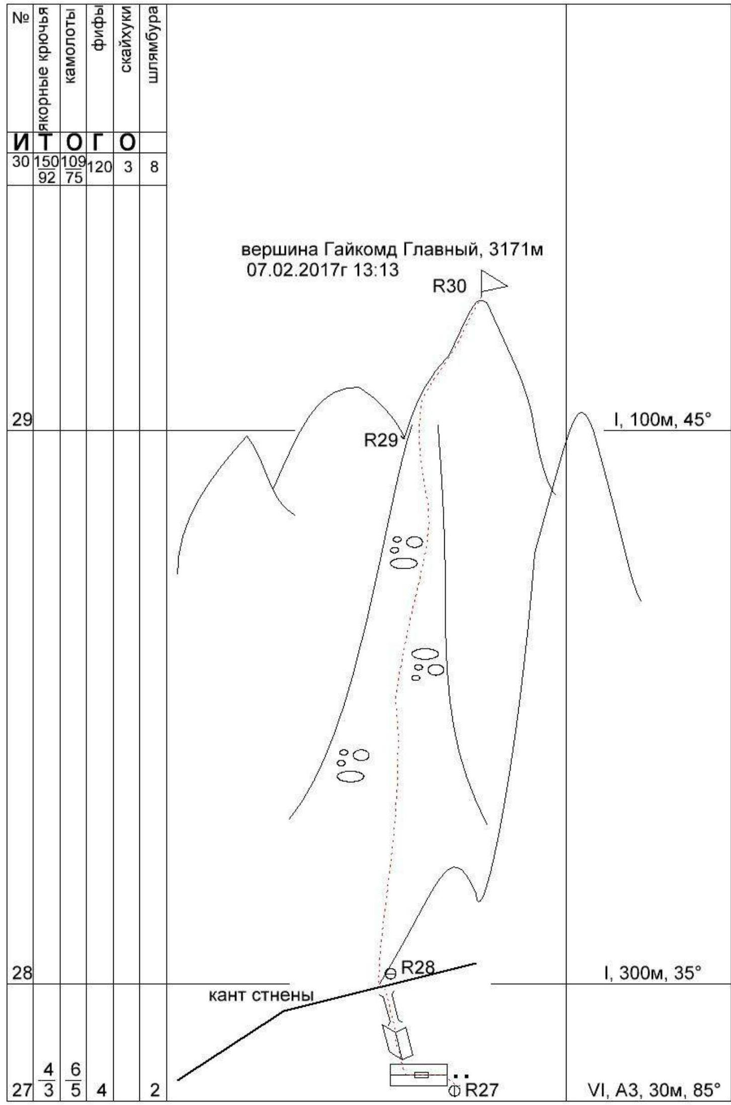
| № | Anchor Pitons | Camalots | Fifis | Skyhooks | Bolts | Category | Length, m | Steepness |
|---|---|---|---|---|---|---|---|---|
| 30 | I | 100 | 45° | |||||
| 29 | I | 300 | 35° | |||||
| 28 | VI | А3, 30 | 85° |
Section Descriptions
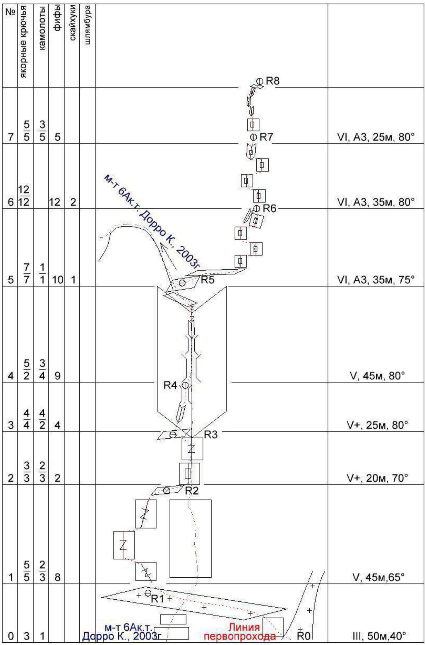
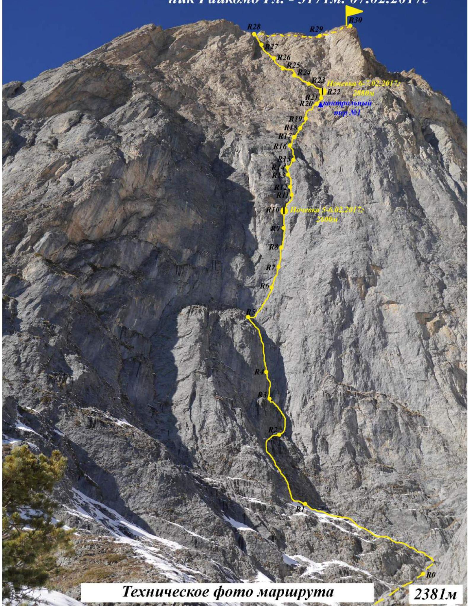
R0–R1. Start from the snowy couloir. 50 m, 40 min, III. Left and up — a small wall about 7 m, exit onto a large ledge with snow. Traverse left about 40 m. Station on the wall to the right on anchors. One bolt hanger is present (placed during the descent from Dorro's route — 2003).
R1–R2. 50 m, 50 min, V. From the station, left and up the wall with cracks and grass. Initially, left into a vaguely defined internal corner, then straight up, and right along an inclined ledge with cracks. Here, the route converges with Dorro's 6A route (2003) for about 80 m. Station on a ledge, shared, on several pitons linked by a rope.
R2–R3. 20 m, 70 min, V+. Up a steep wall with rich relief, numerous cracks and fissures. Exit onto a flattening, station on a ledge at the base of a large internal corner with a chimney.
R3–R4. 25 m, 80 min, V+. Up the left wall of the internal corner, then through an expanding chimney. Exit to another rappel station. Station is hanging, in the chimney on rock pitons and channels, linked by a rope.
R4–R5. 45 m, 80 min, V+. Up the chimney, then into an internal corner, relief becomes more gentle. Through a series of small walls and ledges — exit onto a ledge, short of about 10 m from the top of the bastion (short of R4 on Dorro's route). Organize a station to the right on the wall, near a short ledge that extends right for 5 m.
R5–R6. From this point, the routes diverge. 35 m, 75 min, VI, A3. Start of the first key section.
- Right from the station along a narrow short ledge about 5 m.
- Then up and slightly right on a smooth, vertical wall, using cavities, shells, and small cracks on fifis and skyhooks.
- Protection only on anchors, sometimes placed very tenuously, in horizontal cracks.
- One step on a "hole" skyhook with a diameter of 6 mm.
- Station is hanging in a short internal corner.
R6–R7. 35 m, 80 min, VI, A3. Up, with the orienting feature being grass tufts at the top, left of a large black streak. The wall angle increases, with less relief. Requires transitioning left and right in search of shells and cracks, also using fifis, anchors, and skyhooks. Two steps on "hole" skyhooks. Station is hanging on natural relief.
R7–R8. 25 m, 80 min, VI, A3. Up the smooth wall, then through a crack, followed by a wall flexure — start of an internal corner with a crack. Up the corner — exit onto a small grassy ledge. Hanging station on personal anchors.
R8–R9. 20 m, 85 min, VI, A3. Up the logical corner, through a crack. Hanging station.
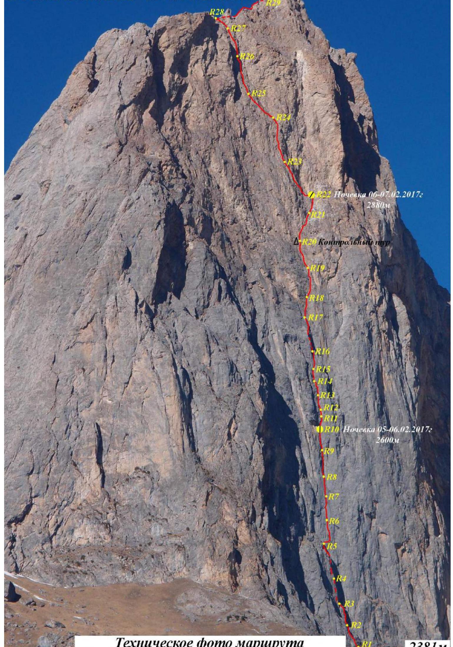
R9–R10. 30 m, 85 min, VI, A3. Up the wall, into an internal corner. Along the corner, slightly right and up, exit onto a grass tuft on the wall. Station on personal anchors, with rich relief. To the right of the tuft, a bolt hanger is placed without an eye for platform setup. First bivouac was organized here.
R10–R11. 15 m, 80 min, VI, A3. From the station, up and right on the wall, avoiding an overhanging part of a large corner to the right. Through a vertical chimney in the internal corner — exit onto small tufts in the corner. Semi-hanging station.
R11–R12. 10 m, 65 min, V+, A2. Slight flattening, left and up on the wall, into a small chimney. From the chimney, exit into an internal corner with a wide right wall. Station on personal anchors and a bolt hanger.
R12–R13. 30 m, 80°, VI, A2. From the station, up through logical wide fissures overgrown with grass tufts. Exit onto a small comfortable ledge. Semi-hanging station on personal anchors.
R13–R14. 15 m, 75 min, VI, A2. From the ledge, up through a narrow chimney, then through a wall — exit onto a good ledge. The ledge can accommodate a sitting bivouac for 3-4 people. Station is comfortable, on the ledge.
R14–R15. 30 m, 75 min, VI, A2. From the ledge, right and up through cracks and fissures towards the rib to the right. Exit beyond the rib, hanging station on the boundary of a flexure.
R15–R16. 45 m, 80 min, VI, A2. From the rib, straight up into a large internal corner, through fissures and chimneys — logical ascent left and up onto a bastion. Semi-hanging station at the top of the bastion ("ogurets").
R16–R17. 30 m, 65 min, V. From the bastion, right and up, "coil climbing" on friction through "ram's foreheads", then through cracks — exit onto a ledge. Comfortable station.
R17–R18. 30 m, 80 min, VI, A2. Along the ledge, traverse right to a vertical wall. Up the wall. Relief is very crumbling, with debris falling on the belayer. Exit onto a ledge, comfortable station.
R18–R19. 35 m, 80 min, VI, A2. From the ledge, slightly right, up a vertical wall with two parallel cracks. Exit onto a flattening, through grassy ridges and scree — onto a good ledge under a rusty overhanging wall. Comfortable station on the ledge.
R19–R20. 50 m, 75 min, V+, A2. From the station, initially left and up on the rusty wall, then straight and right and up through very crumbling relief, traversing right and up — exit onto a ledge with a large accumulation of marble boulders of peculiar shapes, with large crystalline inclusions. Comfortable station on the ledge. A control cairn made from a plastic bottle is located in a nearby grotto, with 4 bottles of 1.5 liters of water left for subsequent groups.
R20–R21. 40 m, 60 min, V+. From the station, up, left of the marble accumulation, climbing through cracks and fissures to an internal corner, then up the corner — exit onto a ledge. Comfortable station.
R21–R22. 20 m, 65 min, V. Up and right on the wall, into an osypnoy couloir with "ram's foreheads", exit from the couloir left through a small wall — onto a large sloping ledge. Along the ledge, slightly left.
- Station on personal anchors near a grotto.
- Two bolt hangers are hammered above and to the left of the grotto for platform setup, with an eye screwed off to the right.
- Second bivouac was here.
- 2 liters of water in a bottle were left in the grotto for subsequent groups.
R22–R23. 35 m, 75 min, VI+, A3. Along the ledge, traverse left to the wall. Up and left on the wall — challenging climbing and ITO. Exit onto a small ledge, semi-hanging station on personal anchors.
R23–R24. 40 m, 80 min, VI+, A3. From this point, the second key section begins and continues to the ridge. From the station, up, then traverse left beyond the rib. Along the rib, straight up through a small wall to a station. The entire rock is conglomerate, making it difficult to organize reliable anchors. Station is hanging on a bolt hanger and personal anchors.
R24–R25. 35 m, 85 min, VI, A3. From the station, traverse left about 5 m, then up the wall — exit beyond a flexure. Strenuous climbing with unreliable anchors. Beyond the flexure, traverse left onto a ledge. Station is comfortable, on personal anchors.
R25–R26. 40 m, 80 min, VI+, A4. From the ledge, slightly left and up a vertical wall, through an internal corner transitioning into a chimney. Exit onto a ledge, traverse along the ledge left to a semi-hanging station on personal anchors. Unreliable rock, everything crumbles and falls.
R26–R27. 45 m, 85 min, VI+, A4. From the station, up and right, then left, and again right and up on white, very crumbling rocks. Very strenuous climbing with extremely unreliable anchors. A bolt hanger is placed in the gap for protection. From the bolt hanger, slightly left and up to a hanging station on personal anchors and two bolt hangers.
R27–R28. 30 m, 85°, VI, A3. From the station, traverse left to an internal corner. Up the corner and through a chimney — exit onto the ridge. Comfortable station on the ridge on the right wall.
R28–R29. 300 m, 30 min, I. Right and up through a rock step, then up a simple scree slope towards the summit.
R29–R30. 100 m, 45 min, I. Through accumulations of large stones — onto the summit of Gaikomd Main 3171 m.
Descent via 1B category route.
Gaikomd Main Peak — 3171 m, February 7, 2017
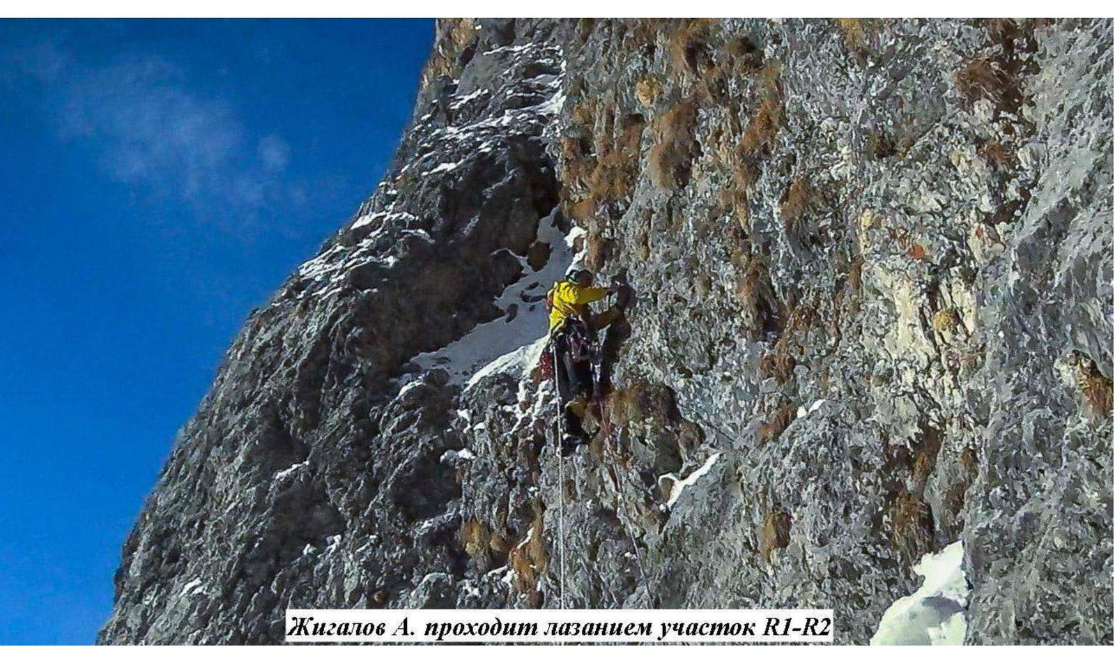
Zhigalov A. climbing the R1–R2 section
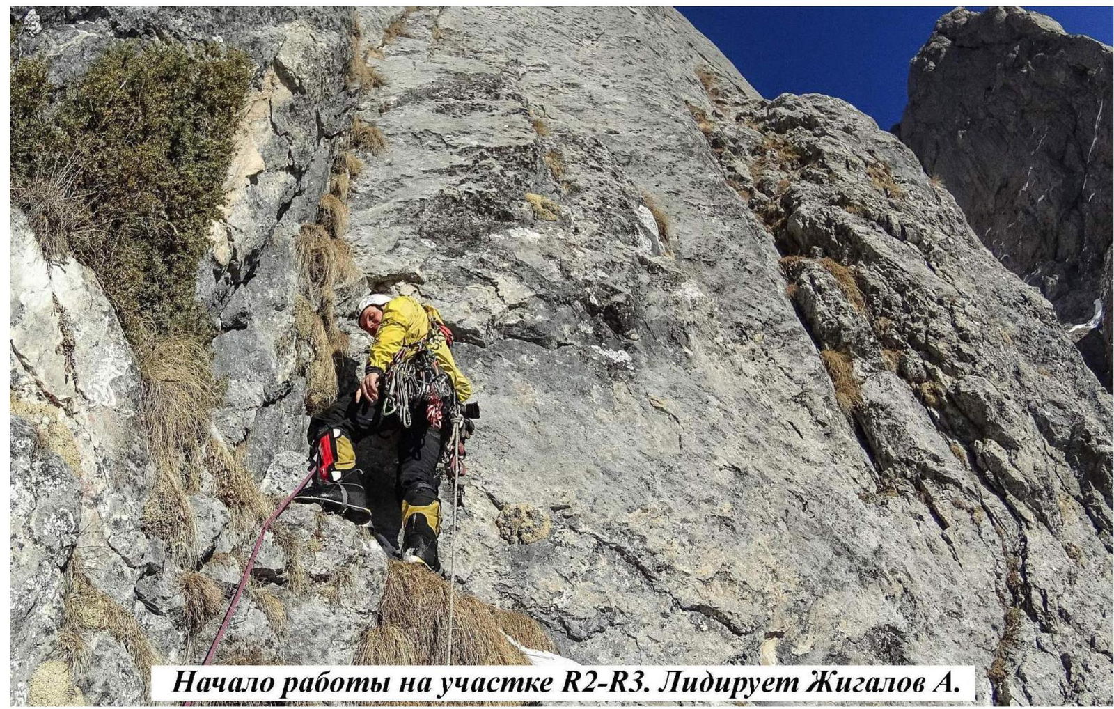
Start of work on R2–R3 section. Zhigalov A. leading.
Zhigalov A. on ITO, R5–R6 section
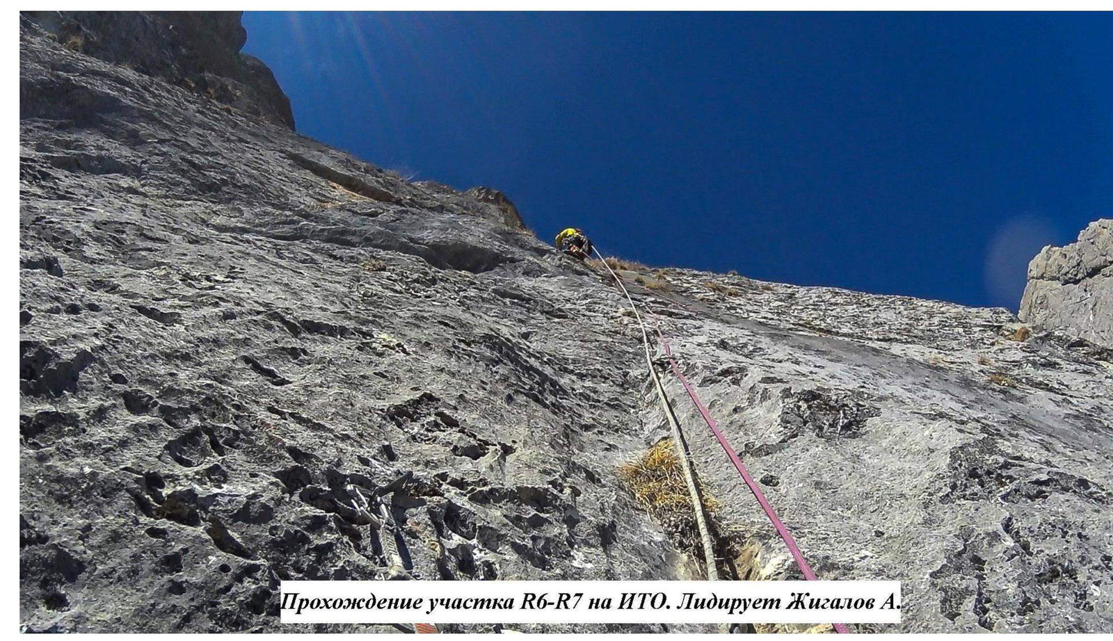
Climbing R6–R7 on ITO. Zhigalov A. leading.
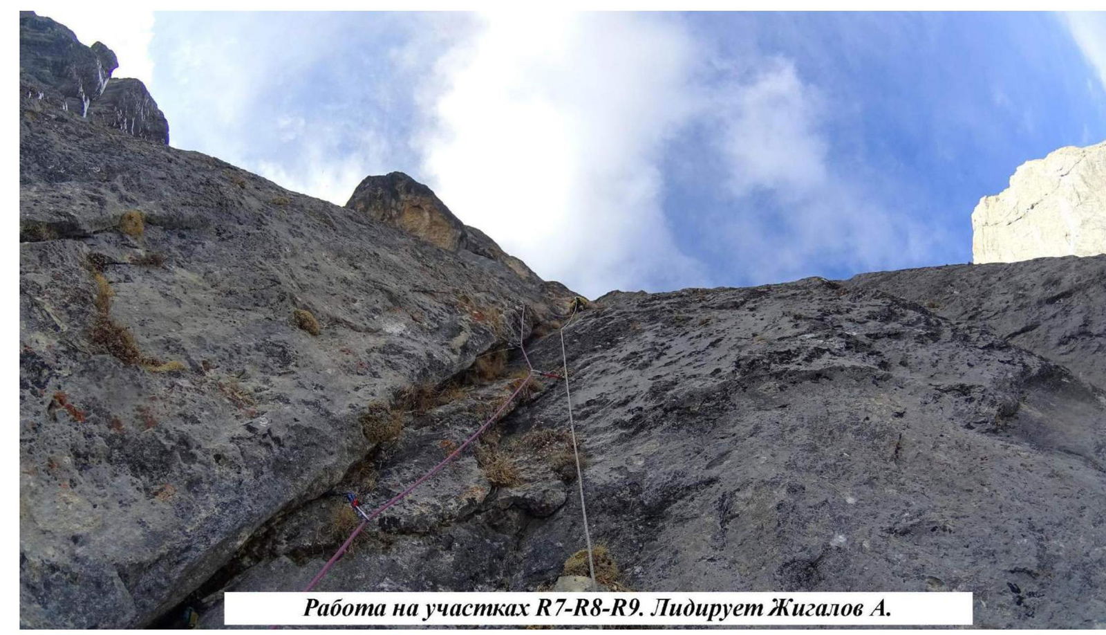
Work on R7–R8–R9 sections. Zhigalov A. leading.
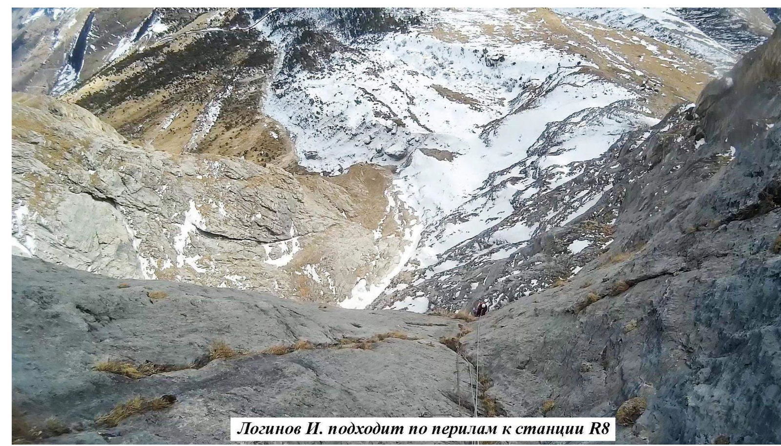
Loginov I. approaching R8 station via fixed ropes
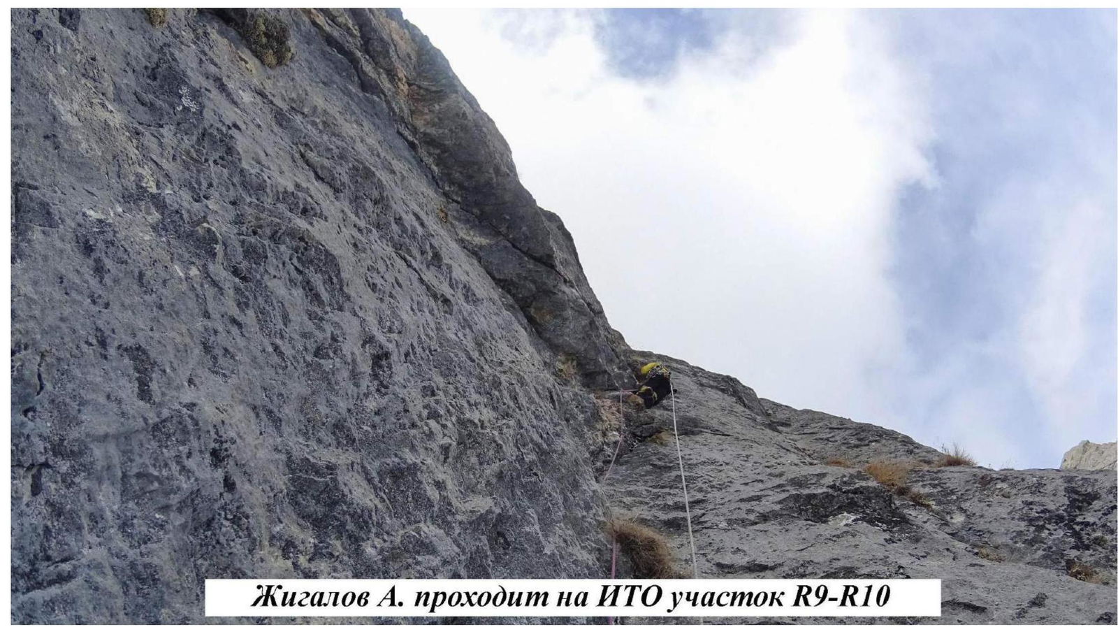
Zhigalov A. on ITO, R9–R10 section
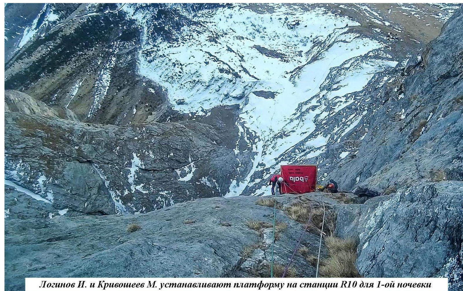
Loginov I. and Krivosheev M. setting up a platform on R10 station for the first bivouac.

Loginov I. climbing R12–R13
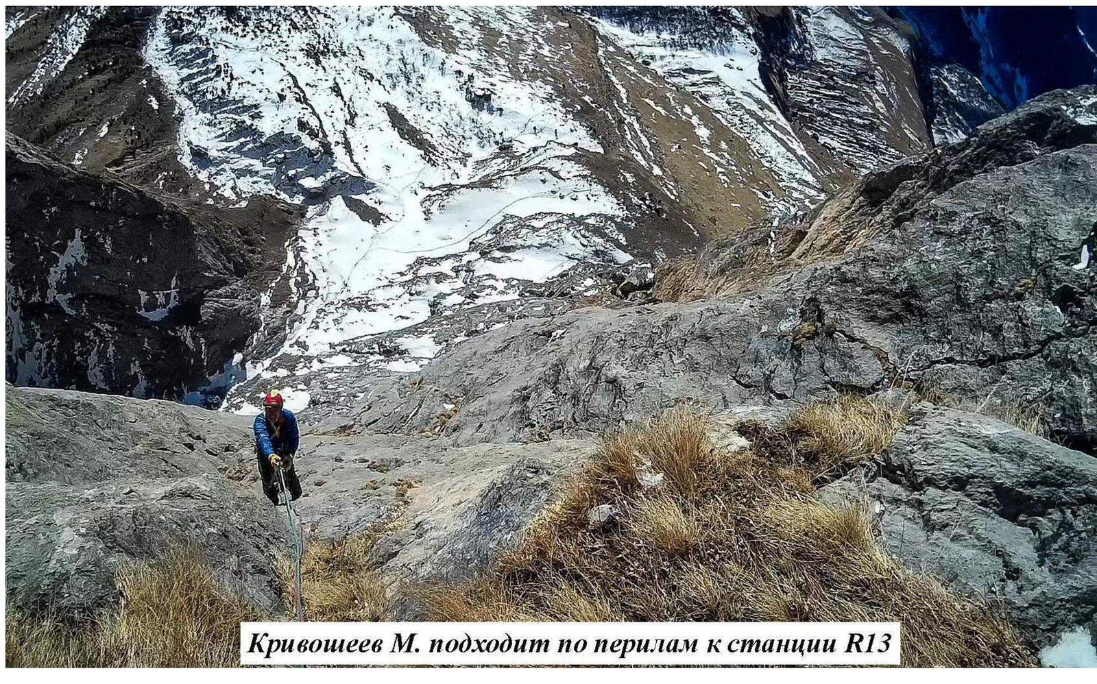
Krivosheev M. approaching R13 station via fixed ropes
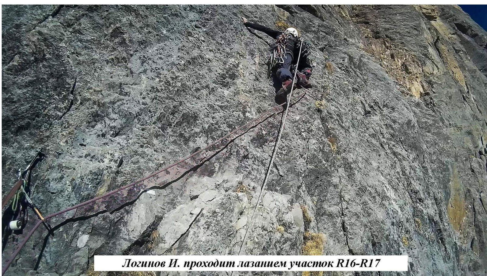
Loginov I. climbing R16–R17

Climbing R22–R23. Loginov I. leading. Photo taken from R22 station (2nd bivouac).

Loginov I. on R22–R23 section
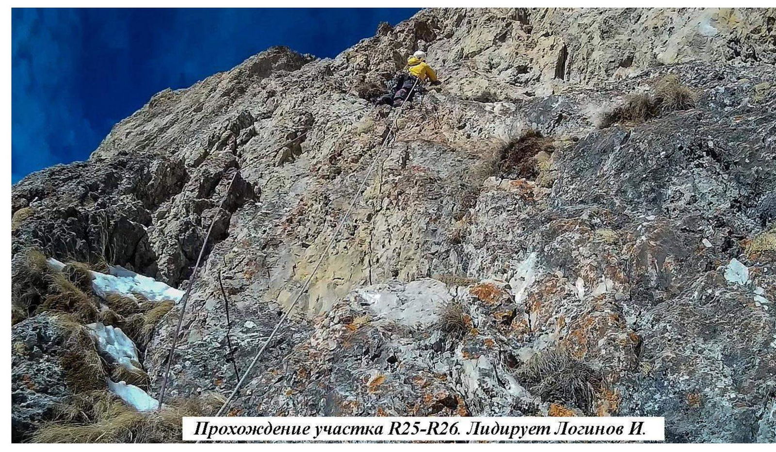
Climbing R25–R26. Loginov I. leading.
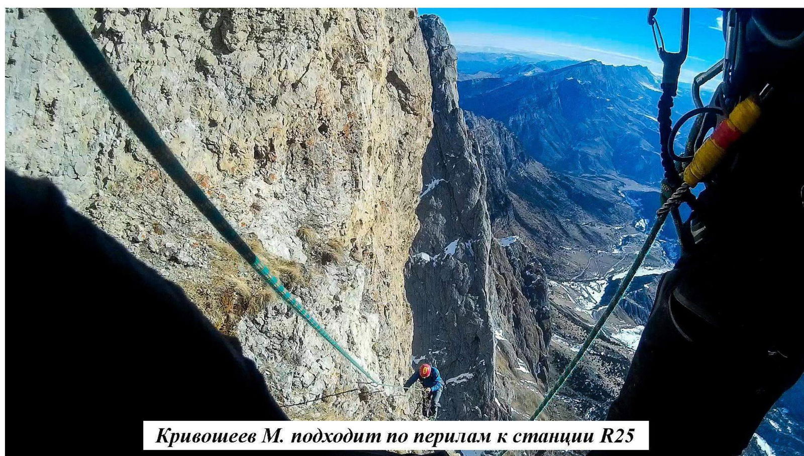
Krivosheev M. approaching R25 station via fixed ropes
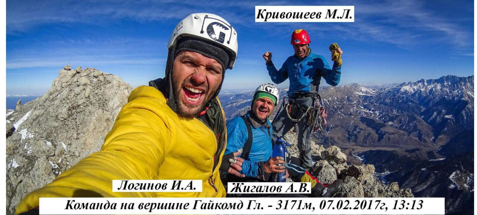
Team on Gaikomd Main summit — 3171 m, February 7, 2017, 13:13
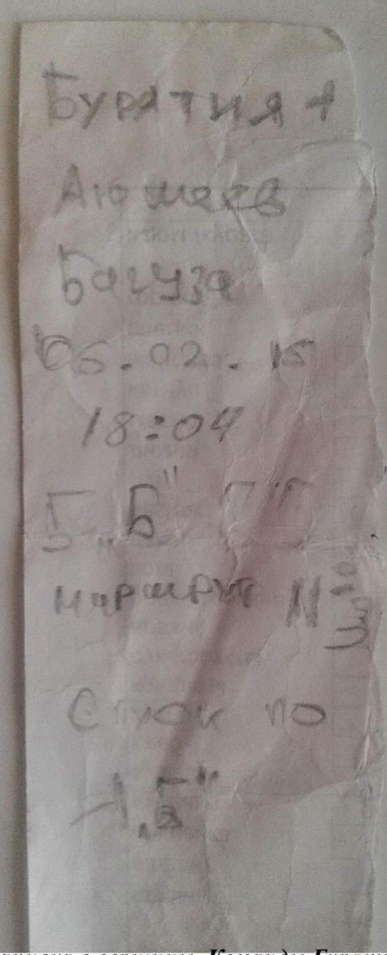
Summit register. Team Buryatia–1. Ayusheev D. — Baguza A. from February 6, 2017. Retrieved on February 7, 2017 at 13:13.
Comments
Sign in to leave a comment