
REGIONAL PUBLIC ORGANIZATION "FEDERATION OF ALPINISM OF MOSCOW REGION"
Russian Championship in Alpinism
2024 year
High-Altitude Technical Class
Report
on the ascent made by the team of GK UAL Moscow Region – Perm Krai to the summit of Tsey-Loam (Kyazi), 3171 m via the left part of the SE wall (K. Dorro's route), 6A category of complexity, from 04.06.2024 to 04.06.2024
Cherepovets 2024
ASCENT DOCUMENT
| 1.1 | Full name, sports rank of the team leader | Chikin Artem Borisovich (CMS) |
|---|---|---|
| 1.2 | Full name, sports rank of the participants | Goryaev Yuri Nikolaevich (1st sports rank) |
| 1.3 | Full name of the coach | Yakovenko Alexander Nikolaevich (MS) |
| 1.4 | Organization | Federation of Alpinism of Moscow Region |
| 2. Characteristics of the ascent object | ||
| 2.1 | Region | 2.9. From the Krepostnoy Pass to the Shaviklde peak |
| 2.2 | Valley | |
| 2.3 | Number of the section according to the 2013 classification table | 61 |
| 2.4 | Name and height of the peak | Tsey-Loam (Kyazi) 3171 m |
| 2.5 | Geographical coordinates of the peak (latitude/longitude), GPS coordinates | 42°46′40″ N 44°58′47″ E |
| 3. Characteristics of the route | ||
| 3.1 | Name of the route | via the left part of the SE wall |
| 3.2 | Category of complexity | 6A |
| 3.3 | Degree of route development | |
| 3.4 | Relief characteristics of the route | Rock |
| 3.5 | Height difference of the route (data from altimeter or GPS) | 792 m |
| 3.6 | Length of the route (in meters) | 1180 m |
| 3.7 | Technical elements of the route (total length of sections of various complexity categories with indication of relief characteristics (ice-snow, rock)) | Length of sections 6 cat. diff. – 175 m, 5 cat. diff. – 415 m |
| 3.8 | Average steepness of the route, (°) | |
| 3.9 | Average steepness of the main part of the route, (°) | 75° |
| 3.10 | Descent from the peak | Via route 1B cat. diff. |
| 3.11 | Additional characteristics of the route | Lack of water |
| 4. Characteristics of the team's actions | ||
| 4.1 | Time of movement (team's walking hours, in hours and days) | 9 h 40 min on June 4, 2024 from 3:00 to 13:40 |
| 4.2 | Overnight stays | |
| 4.3 | Time of route development | 0 h, 0 days |
| 4.4 | Exit to the route | 4:00 on 04.06.2024 |
| 4.5 | Exit to the peak | 13:40 on 04.06.2024 |
| 4.6 | Return to the base camp | 15:40 on 04.06.2024 |
| 5. Characteristics of weather conditions | ||
| 5.1 | Temperature, °C | June 4, 2024, during the day 20–25 °C |
| 5.2 | Wind force, m/s | Up to 1–2 m/s |
| 5.3 | Precipitation | June 4, 2024, during the day 0 |
| 5.4 | Visibility, m | Excellent |
| 6. Person responsible for the report | ||
| 6.1 | Full name, e-mail | Goryaev Yu. N. yugoryaev@yandex.ru mob. 89526566184 |
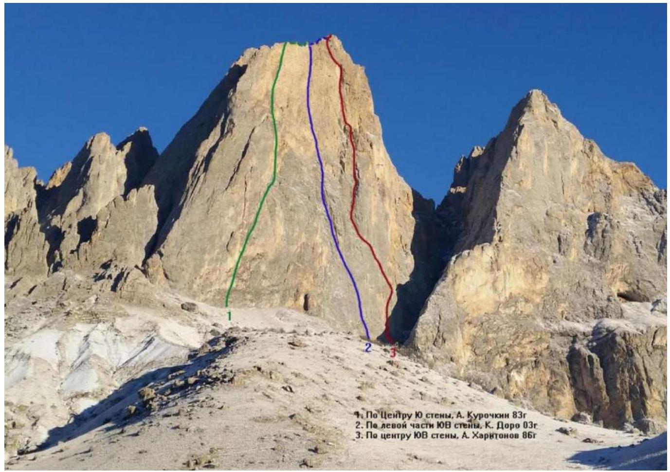
Attached photo of the peak with indication of nearby routes
Blue: Route via the left part of the SE wall (Dorro, 2003) 6A cat. diff.
3. Technical description of the route
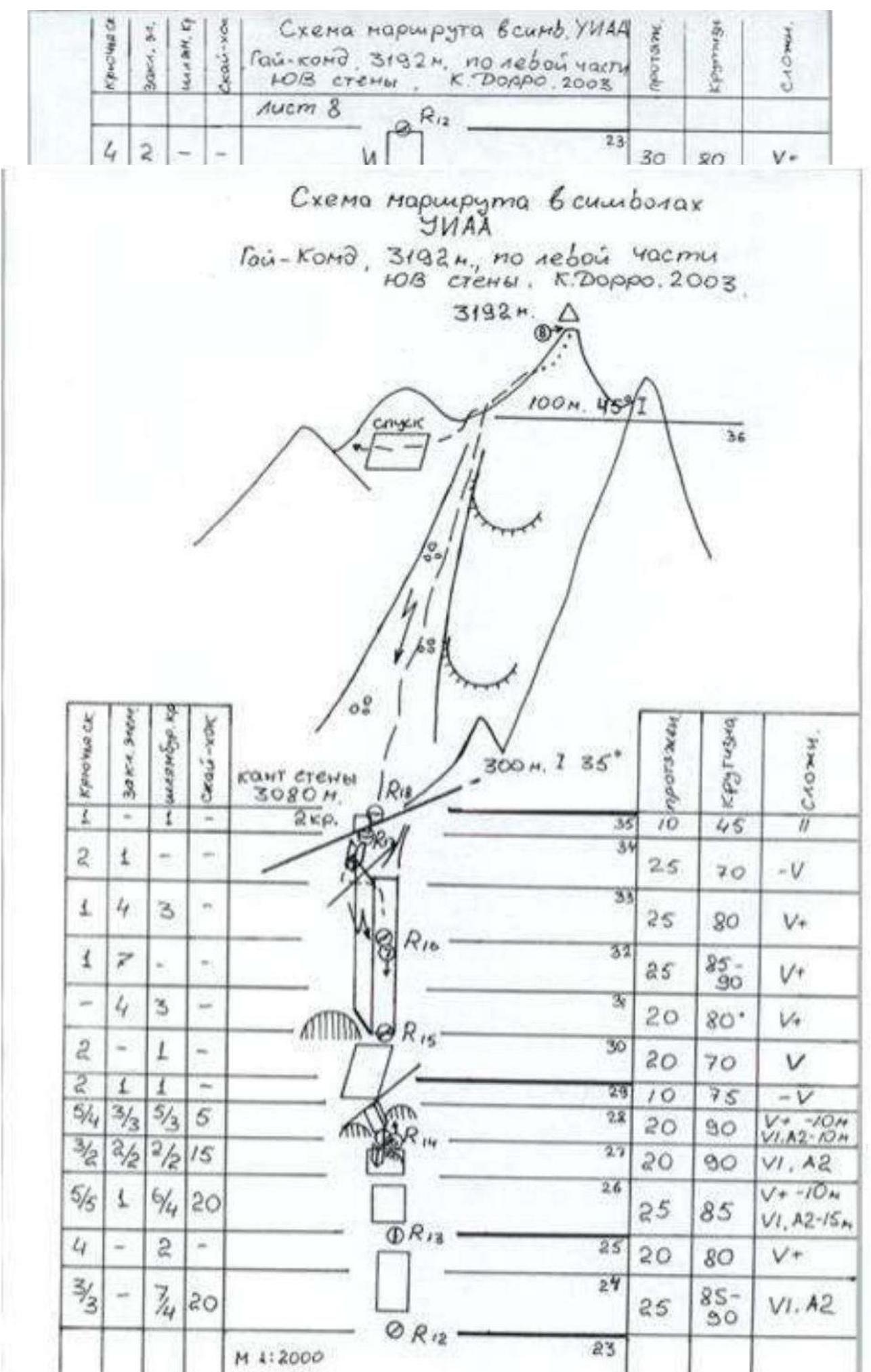
UIAA scheme taken from the description of the first ascenders:
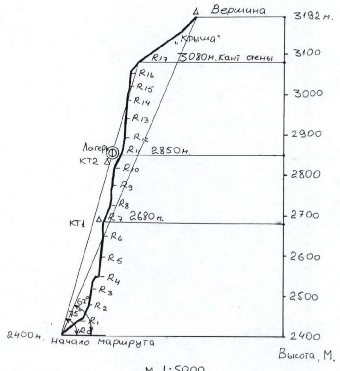
This route profile:
Tactical actions of the team
On June 4, 2024, we left the base camp at 2:00 am. The approach to the route took 1 h 30 min, we started working at 4:00 am. We took 2 l of water for one day's work on the route. We chose a simultaneous movement scheme. We reached the peak at 13:40.
The total time of movement on the route was 9 h 40 min. Descent was via 2A, marked with flags.
Description of the route by sections
R0–R1: Exit to a ledge via easy rocks. Station on a belay bolt.
R1–R2: From the station, move left along an internal corner overgrown with grass, and then right up to a convenient ledge. Station on pitons.
R2–R3: Then begins a system of steep internal corners, with earth and rocks partially destroyed in the corners.
R3–R4: Up the internal corner, the corner lies left, exit to a grassy ledge. Convenient station on a large ledge on belay bolts.
R4–R5: From the station, move left along the ledge for 6 m (bypass the outer corner) and then move up along a vertical internal corner. For belaying on this rope, mainly pitons are used. Station is hanging.
R5–R6: Further up along the same internal corner. Climbing is relatively easy. However, the cracks are filled with earth and dust. Especially unpleasant are the tufts with dry grass, from which dust pours out when touched.
R6–R7: Along the corner, bypassing a cornice on the right, exit to a slab. Along it, left up. Enter an internal corner. Station.
R7–R8: Further along the internal corner, with grass and tufts in places. The rope is not difficult. Possible overnight stay location.
R8–R9: Then move right up along the corner with sounding slabs through a small overhang. Climbing is not difficult; before exiting the overhanging corner on the right, there is a belay bolt. Station on a gentle slope on the right on a belay bolt and piton.
R9–R10: From the station, 1 m left, and then move up. Steepness increases. Used ITO on a wall with corners and cracks. For belaying, anchors are used. Further left up, bypassing the overhang on a gentle slope.
R10–R11: Then along a gentle slab right up to a ledge and a niche. Climbing is easy. Station on two belay bolts. There is a ledge about 1 m wide for a lying overnight stay. However, there is little space for a tent.
R11–R12: From this rope begins the second half of the route. The rock is fragile, crumbly. Much destruction. From the station, 3 m right, and then left. Climbing is not difficult. Belaying is sparse.
R12–R13: From the station, first slightly left, then slightly right. Climbing is a bit more difficult through cavities, shells, uneven holes, and depressions in the rock. The relief seems unreliable. Belaying is sparse. Station is hanging.
R13–R14: From the station, left up, orienting on trampled grassy tufts, then up slightly to the right along a not clearly defined outer corner (climbing is difficult, relief is unreliable, problems with setting points, loading points is undesirable), then exit right up under overhanging blocks. Station under overhanging blocks on one new belay bolt and piton. There is a second belay bolt for setting a platform. However, the overhanging huge blocks cause great concern, which are held by a hair's breadth and will immediately destroy both the platform and the station itself in case of a fall.
R14–R15: From the station up, carefully bypassing overhanging blocks, then left up exit to an outer corner (climbing becomes easier), then move right up along easy relief. Station at the base of a large internal corner to the right of it (pass along a small ledge to the right from the base of the internal corner). Station on two belay bolts.
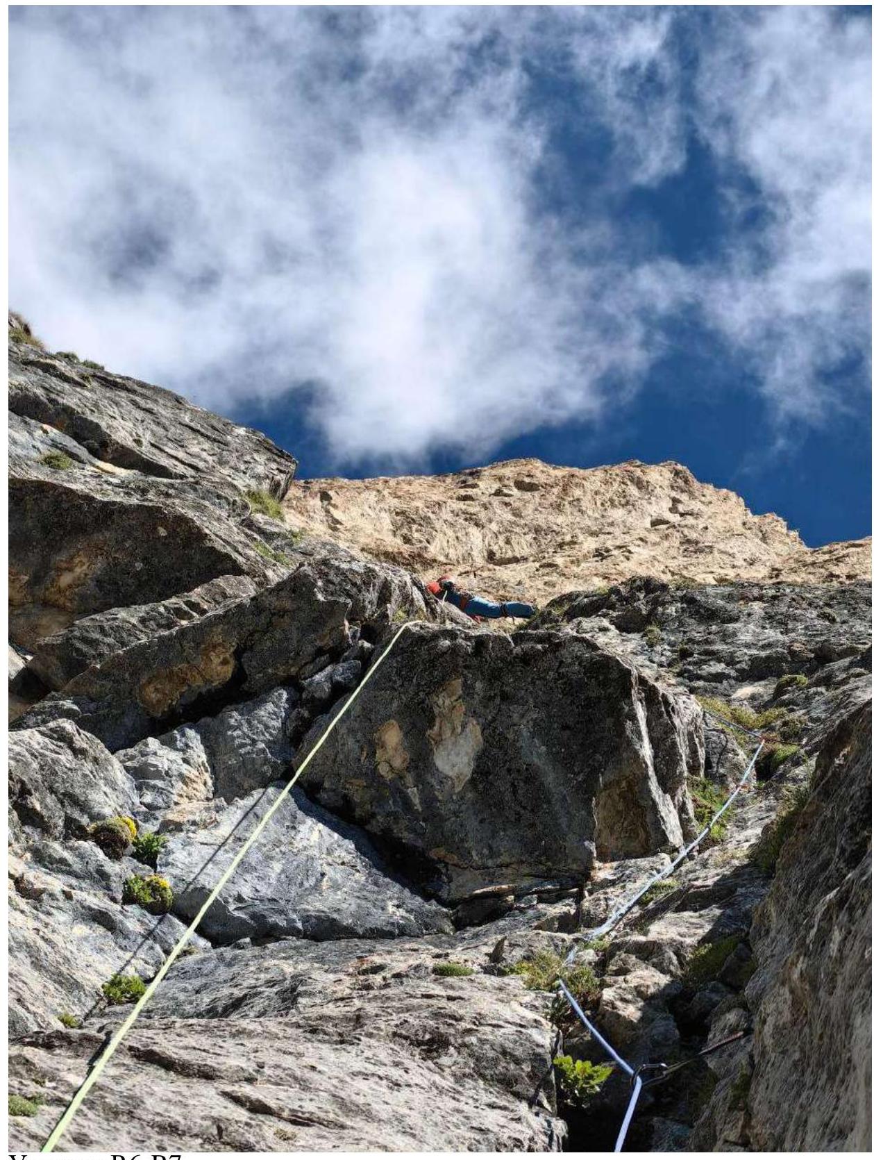
R15–R16: From the station, left into a large internal corner and move up along it. In our opinion, this is the most dangerous section of the route due to the destruction of the relief. It pours down heavily. Climbing is not difficult, but most handholds break off. Moreover, stones fly straight at the belayer. Therefore, it is necessary to climb very carefully. Belaying with friends inside the corner.
R16–R17: Continue moving up along the internal corner. Climbing becomes easier. Station on a large boulder on the ridge. Length of the section is 60 m.
R17–R18: Then to the right. Rocks are easy. Move on foot along crumbly rocks to the peak.
R18–Peak
Photo report of the route passage
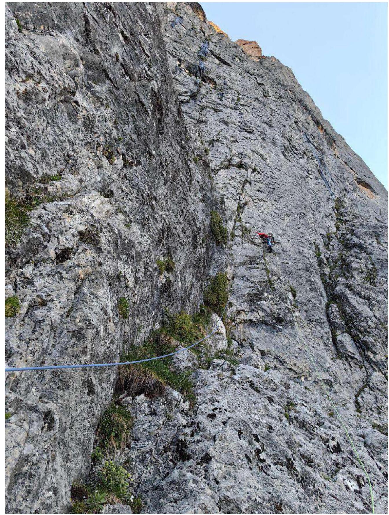
Section R2–R3
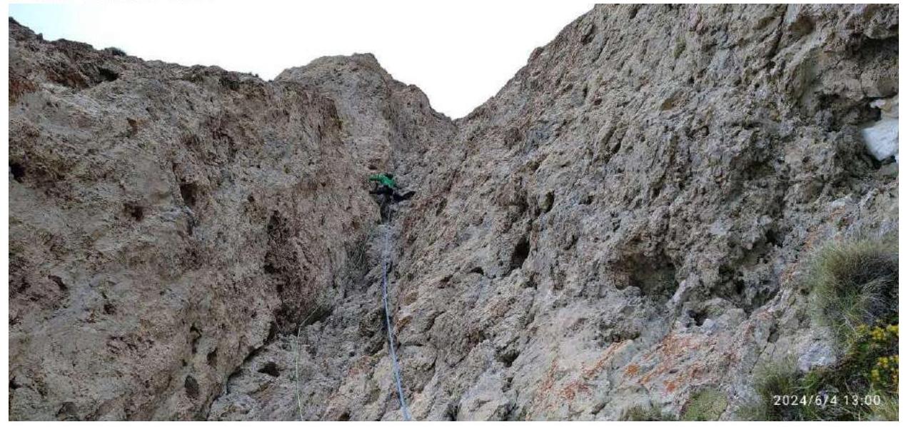
Section R6–R7

Section R11–R12
Section R15–R16
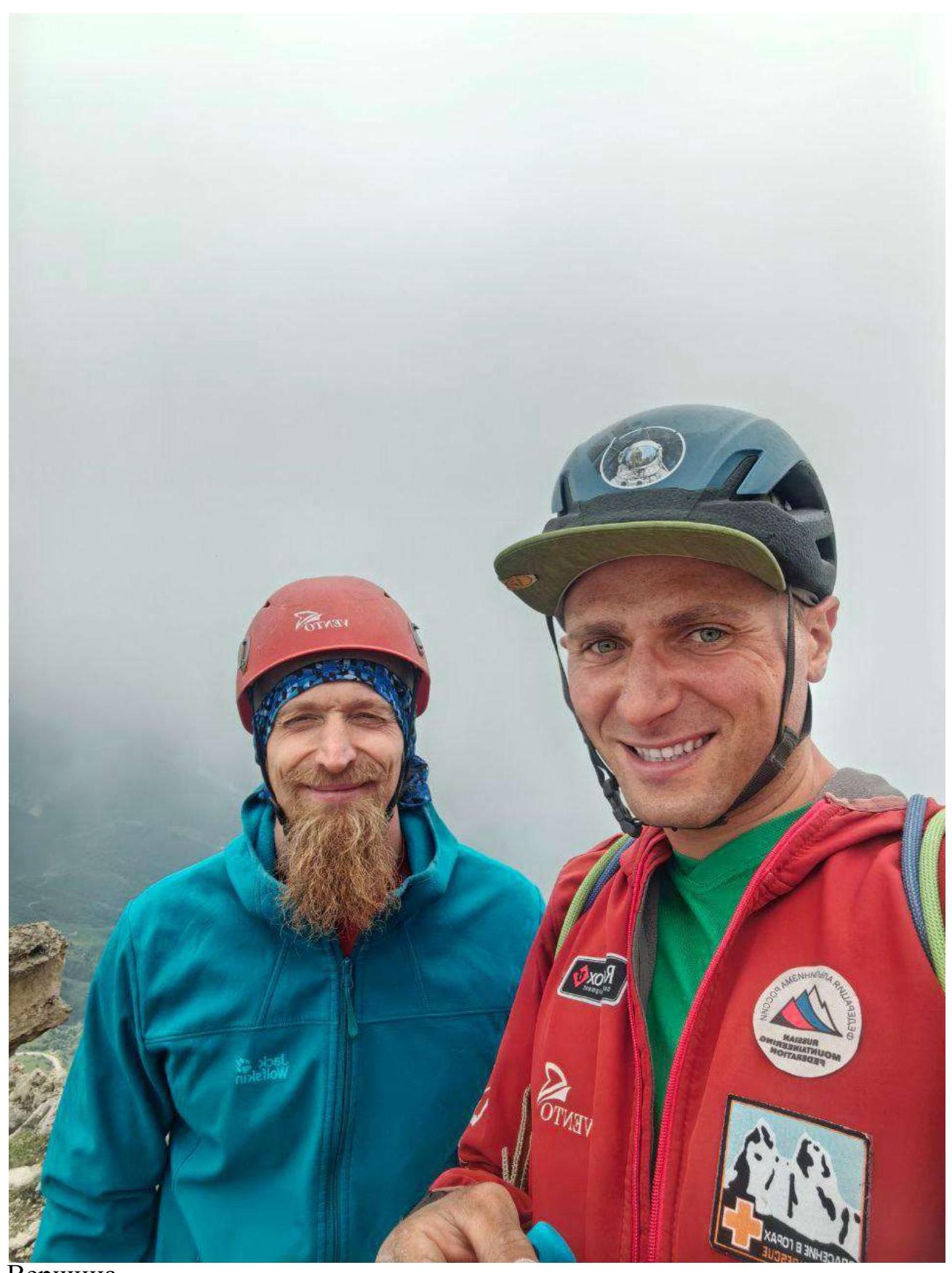
Peak
Comments
Sign in to leave a comment