Ministry of Sports of Krasnoyarsk Krai
Krasnoyarsk Regional Alpine Federation
Russian Mountaineering Championship
2018
Snow and Ice Class
Report
On the first ascent by the Krasnoyarsk Krai team – 1 to the summit of Gaikomd (Kyazi) Main, 3171 m, via the central left part of the SE wall, named "Nebo yanvarya" (January Sky). The first ascent is approximately category 6A difficulty. Krasnoyarsk 2018
Team Leader:
Zhigalov Alexander Vladimirovich
Team Members:
- Loginov Igor Alexandrovich
- Krivosheev Maxim Leonidovich
Coaches:
Zakharov Nikolai Nikolaevich Balezin Valery Viktorovich
Report Contact:
Zhigalov A.V., 0jog@bk.ru, +7–983–574–84–88
Ascent Details
- Region – from Krestovyi pass to Shaviklde peak, p. 2.9
- Summit – Gaikomd (Kyazi, Girech, Tsey-Loam) Main, 3171 m, via the center of the left part of the SE wall, named "Nebo yanvarya" (January Sky)
- Proposed category – 6A, first ascent
- Route type – rock climb
5. Route Characteristics:
Height difference – 730 m, total route length – 1315 m, wall section height difference – 629 m, wall section length – 795 m, length of sections with category 5 difficulty – 270 m, category 6 – 365 m, A1 – 115 m, A2 – 190 m, A3 – 50 m, average steepness of the wall section – 74°.
- Equipment used on the route: anchor pitons – 90/63, camalots – 81/50, about 89 placements on "fifths", 5 placements on skyhooks, 3 drilled pitons left behind, 2 as belay points, 1 on a station with poor relief, 1 anchor piton left on a pendulum.
- Climbing time – 19.5 hours, 2 days. Descent took 3 hours via a category 2A route.
One bivouac on a ledge on the wall.
- Team Leader: Zhigalov Alexander Vladimirovich, Master of Sports Team Members: Loginov Igor Alexandrovich, Master of Sports; Krivosheev Maxim Leonidovich, Master of Sports
- Coaches: Balezin Valery Viktorovich, Master of Sports of International Class, Honored Coach Zakharov Nikolai Nikolaevich, Master of Master Sports of International Class, Honored Coach
- Departure date: To the route – 7:00 AM, January 28, 2018 To the summit – 4:19 PM, January 29, 2018 Return to Base Camp – 8:00 PM, January 29, 2018
- Report Contact: Zhigalov Alexander Vladimirovich, phone: 8–983–574–84–88 Email: 0jog@bk.ru
- Ascent organized by – Ministry of Sports of Krasnoyarsk Krai 2018
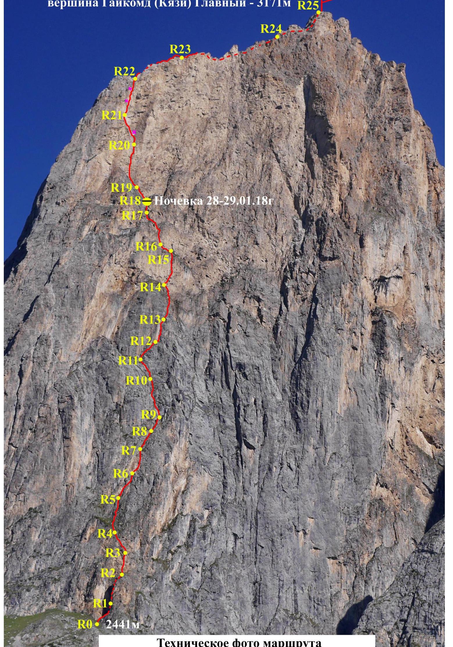
Gaikomd (Kyazi) Main Peak – 3171 m


General photo of the summit. The "Nebo yanvarya" (January Sky) route by the Krasnoyarsk Krai team – 1 (Zhigalov A.V., Loginov I.A., Krivosheev M.L.)
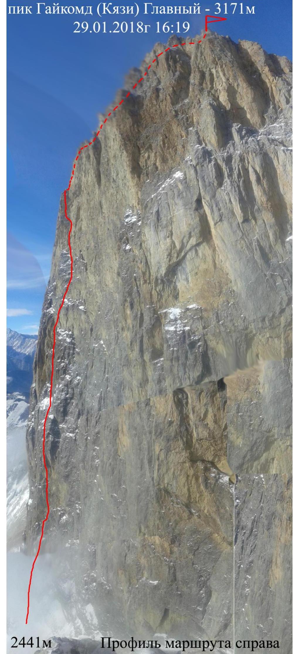
2441 m
Route profile from the right
Summit on January 29, 2018, at 4:19 PM
Approaching the 3070 m ridge, Gaikomd Main, 3171 m


Area photopanorama
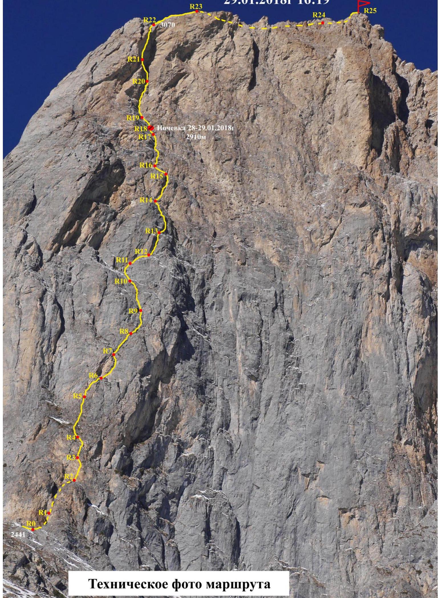
Climbing Area Overview
The Gaikomd massif is located in the Skalisty Range of the Greater Caucasus, between the Terek River (to the west) and the Assa River (to the east). Gaikomd Main is the highest peak in the massif, towering above the Central and Eastern peaks. Previously known as "Girech", it is now referred to as "Tsey-Loam" in the classifier, and also called "Kyazi". The administrative border between Ingushetia and North Ossetia-Alania runs along the ridge to Gaikomd Main and then heads north. The ascent route and approaches are located in the Dzheyrakhsky district of Ingushetia.
The base camp is on a large clearing, 200 m from the border post. Construction of the "Kyazi" alpine camp is set to begin this year, which will operate year-round. The most comfortable accommodations are about 2 km along the road from the border post, at the "Legends of the Mountains" hotel and the Basejumpers' base.
No border permits are required to visit the Gaikomd peaks, but it is necessary to notify the border post of your presence.
Mobile coverage is available through Beeline and Megafon networks, and MTC on the wall and at higher elevations. Internet is also available. Weather in the area is relatively stable, with snowfall periods lasting 2-3 days, and snow melts quickly on the routes. This should be considered when planning lengthy wall ascents. In winter, after heavy snowfalls, be cautious of couloirs and windward slopes due to potential avalanches.
The approach to the route takes about 1 hour. Move towards the southern walls of Gaikomd Main along a grassy ridge, left of a large couloir between Gaikomd Main and Gaikomd Central. The start of the route is a large crack to the left.
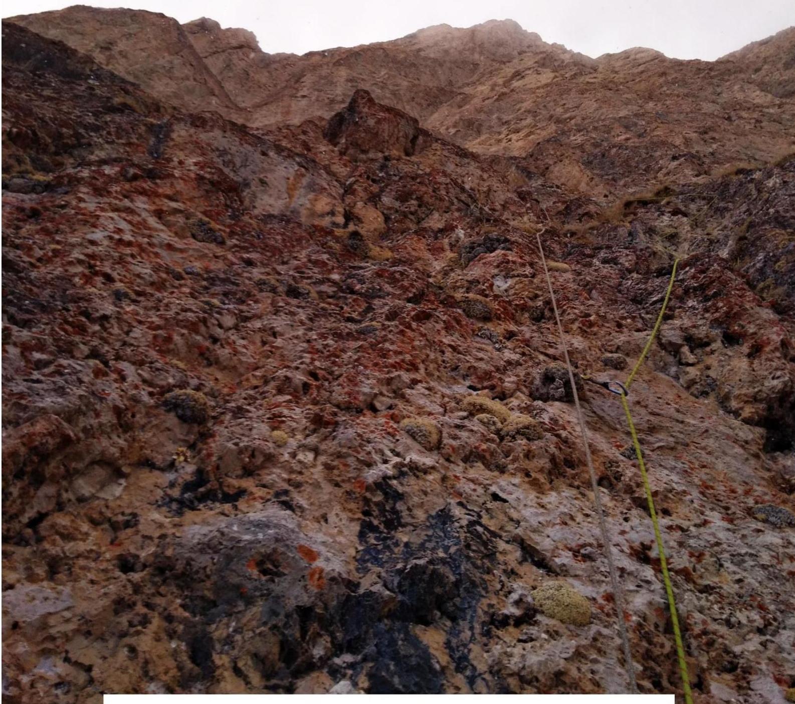
The Gaikomd ridge is composed of sedimentary rocks – limestone, partially metamorphosed. The wall alternates between rocky sections with a yellow-white hue and more monolithic gray rocks. The area is rich in various cracks, fissures, and cavities, resembling Crimean walls like Morcheka, Forossky Kant, and Sokol. Much of the relief is filled with earth, grass, and tufts, requiring careful cleaning before placing reliable protection, and the fine grass dust can be a nuisance. The upper part of the wall is quite steep and crumbling, similar to Ak-Kaya and Kara-Kaya in Bezengi, and Erydag in Dagestan. The rock is fragile, with sections of soft chalk inclusions. Fissures often contain fragments of broken rock and "live" stone, complicating the placement of reliable protection. Particular attention should be paid to the reliability and placement of stations.
Team Tactics
In February 2018, the Krasnoyarsk Krai team – 1 completed two ascents on Gaikomd Main as part of the Russian Mountaineering Championship in the technical class. They ascended via route #12 by the St. Petersburg team – 2, and route #10 by Syyshikov A. in 2017. Additionally, as part of the snow and ice class in the Russian Mountaineering Championship, the team completed a new route on Gaikomd Main via the center of the left part of the SE wall. They named the route "Nebo yanvarya" (January Sky). The line runs between the category 5B route by Ayusheev in 2017 and the category 6A route by Dorro K. in 2003. On January 28, 2018, the Krasnoyarsk team – 1, consisting of Zhigalov A.V., Loginov I.A., and Krivosheev M.L., left the base camp at 4:30 AM. They reached the start of the planned route by 6:00 AM, gathered, and packed two backpacks with a tent, gear, food, and gas for the anticipated bivouac. They took 1.5 liters of water and began the ascent at 7:06 AM, establishing radio contact with the judge and chief judge. They moved at a quick pace, navigating the wall using photographs. By 1:00 PM, a wind brought dense clouds onto the wall. By 5:00 PM, the leader reached R18. The team made a ledge, placed a tent, and bivouacked for the night. The entire day was led by Loginov I.A., with Zhigalov A.V. second, and Krivosheev M.L. third. On January 29, 2018, at 7:00 AM, the first climber began the ascent. Zhigalov A.V. led, and by midday, they reached R20. They decided to change the leader to Loginov I.A. The key section, R21-R22, proved unexpectedly challenging – a hanging wall with a crack. The crack was wide with crumbling walls, requiring careful placement of protection on the side walls. They used skyhooks on the overhang and drilled two pitons for intermediate protection. By 3:40 PM, the leader reached the ridge. At 4:19 PM, the entire team stood on Gaikomd Main, 3171 m. They made several photos and video recordings and replaced the note in the control tower. The descent took about 3 hours via a category 2A route. The route was climbed without prior processing, in an alpine light style, fast-and-light. They bivouacked on the wall in a tent on a constructed ledge. The team used a simultaneous movement scheme to keep all members in motion and avoid freezing while hanging on stations. The leader wore insulated rock shoes, allowing for "free" climbing on difficult sections. The route proved challenging, labor-intensive, and lengthy, despite the high speed of ascent. The overall angle of the wall is very high, about 74°. Many sections required complex climbing, both physically and psychologically. These sections necessitate "free" climbing with a high level of preparation, as ITO is often impossible due to the crumbling rock. Particular attention must be paid to protection points. Anchor pitons were hammered into deep cracks or placed in cavities horizontally. Camalots occasionally slipped out of calcite cracks. In some areas, relief had to be cleaned for a long time to place reliable protection. The upper part features complex ITO with elements of climbing on crumbling blocks on the overhang, where two pitons were drilled. The new route is more challenging than Dorro K.'s 6A route in 2003, and significantly more difficult than route #12 by the St. Petersburg team – 2, which they completed in 10.5 hours. Syyshikov A.'s 2017 route, category 5B, was completed in 12.5 hours. The new route took 19.5 hours to complete. Based on the above, the team believes the route corresponds to category 6A complexity. This opinion is shared by all team members: Zhigalov A.V., Loginov I.A., and Krivosheev M.L. The team, in this composition, has completed category 6A ascents in winter: 2016:
- Peak Svobodnoi Korei – 6A, Bezubkin V.'s route, in 29 hours;
- Peak Svobodnoi Korei – 6A, first ascent (route "Krasnoyarsky").
2017:
- Gaikomd Main – 6A, first ascent (via the SE wall) in 24.5 hours.
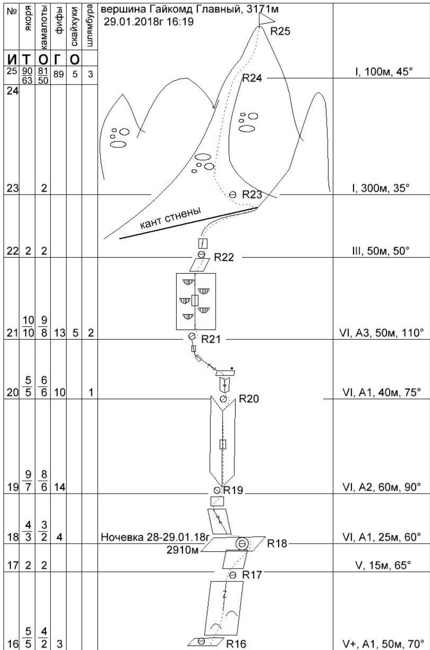
Ascent graph for Gaikomd (Kyazi) Main, 3171 m, via the central left part of the SE wall, "Nebo yanvarya" (January Sky) route

| Section # | Anchors | Camalots | Fifths | Skyhooks | Pitons | Section Description |
|---|---|---|---|---|---|---|
| R0 | II, 50 m, 40° | |||||
| R1 | 3 | 3 | V, 40 m, 60° | |||
| R2 | 3 | 3 | 5 | VI, A2, 20 m, 75° | ||
| R3 | 4 | 3 | 3 | VI, 35 m, 70° | ||
| R4 | 4 | 1 | 2 | III, 40 m, 50° | ||
| R5 | 3 | 3 | 4 | VI, 25 m, 60° | ||
| R6 | 3 | 2 | 6 | VI, A2, 30 m, 85° | ||
| R7 | 2 | 2 | 1 | VI, 30 m, 60° | ||
| R8 | 1 | 2 | 3 | VI, 30 m, 65° | ||
| R9 | 4 | 3 | 4 | V, 50 m, 50° | ||
| R10 | 3 | 4 | V, 30 m, 60° | |||
| R11 | 5 | 1 | 3 | V+, 25 m, 70° | ||
| R12 | 4 | 3 | 4 | VI, A2, 30 m, 90° | ||
| R13 | 3 | 3 | IV, 50 m, 65° | |||
| R14 | 5 | 3 | 10 | VI, A2, 50 m, 80° | ||
| R15 | 3 | 1 | III, 20 m, 50° | |||
| R16 | 5 | 2 | 3 | V+, A1, 50 m, 70° | ||
| R17 | 2 | 2 | V, 15 m, 65° | |||
| R18 | 3 | 2 | 4 | VI, A1, 25 m, 60° | ||
| R19 | 7 | 6 | 14 | VI, A2, 60 m, 90° | ||
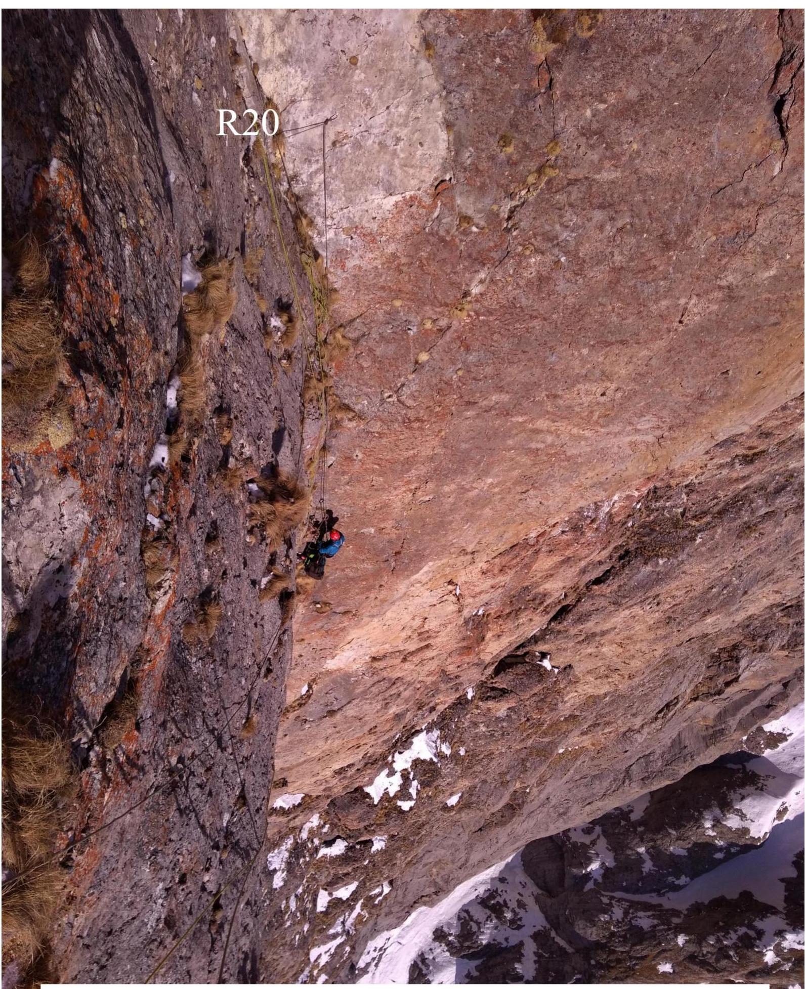
| R20 | 5 | 6 | 10 | 1 | VI, A1, 40 m, 75° | |
| R21 | 10 | 8 | 13 | 5 | 2 | VI, A3, 50 m, 110° |
| R22 | 2 | 2 | III, 50 m, 50° | |||
| R23 | 2 | I, 300 m, 35° | ||||
| R24 | I, 100 m, 45° | |||||
| Total | 90 | 81 | 89 | 5 | 3 |
Section Descriptions
The start of the route is 50 m to the right of Ayusheev D.'s 2017 route. A good landmark is a large "glove" slab detached from the wall. Begin up a couloir and then a chimney to the left of it.
R0–R1. 50 m, 40°, II. Up a steep snowy couloir under an overhang. Station on a ledge between two chimneys.
R1–R2. 40 m, 60°, V. From the station, right up the right chimney, climbing in a wide stance. Exit onto a ledge with bushes between the "glove" and the wall. Station on the ledge with anchors.
R2–R3. 20 m, 75°, VI, A2. Up a yellow steep wall with cracks:
- initially slightly right;
- then bearing left. Exit to a small tree, hanging station.
R3–R4. 35 m, 70°, VI. Up left into a wall with good relief over a ledge. Exit to gentle rocks with grassy tufts. Station on a ledge.
R4–R5. 40 m, 50°, III. Up simple rocks towards a hanging rusty corner. Alternating "ram's foreheads" and grassy tufts. Semi-hanging station in a short internal corner.
R5–R6. 25 m, 60°, VI. Up the corner, transition right. Exit onto an inclined ledge. Station on the ledge in an internal corner under a rusty overhang. A small grotto is on the left.
R6–R7. 30 m, 85°, VI, A2. Up right along a thin crack under the rusty overhang on fifths and anchors. Fifths are sometimes placed on relief. The crack is sometimes blind, ending. Transition through the overhang into the base of a chimney. Station over a ledge on natural relief and anchors.
R7–R8. 30 m, 60°, V. Right up a logical inclined chimney inside a large internal corner over the wall's ledge. Uncomfortable station on personal points.
R8–R9. 30 m, 65°, V. Up an inclined wall with grassy tufts. Alternating "ram's foreheads" with ridges. Station on a ledge.
R9–R10. 50 m, 50°, V. Up a short internal corner, then right along "ram's foreheads" onto a small ledge. Station on personal points with rich relief.
R10–R11. 30 m, 60°, V. Up a wall with a crack left towards a small ledge under a vertical wall.
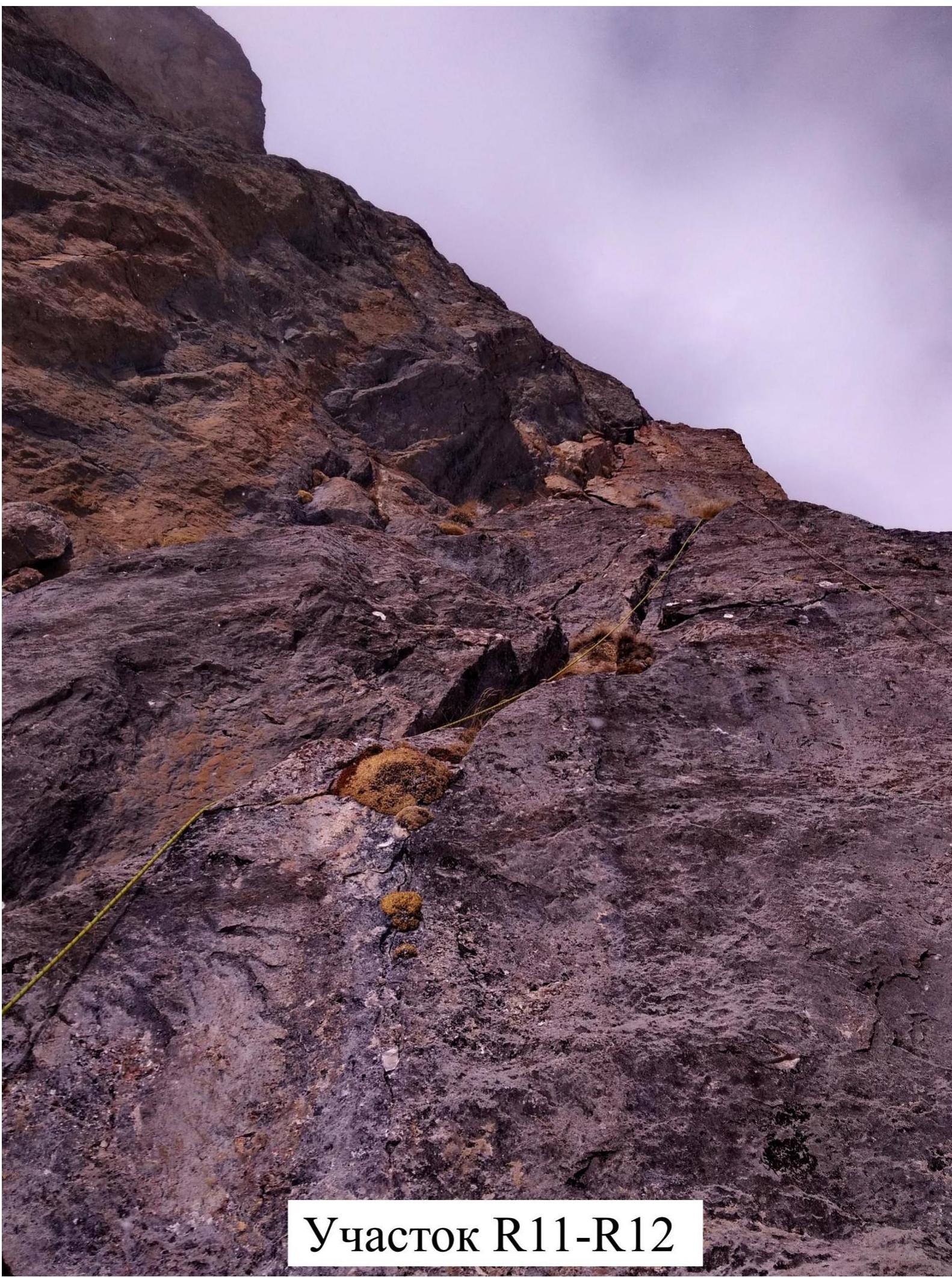
R11–R12. 25 m, 70°, V+. Up a steep wall with a crack right into the base of a large rock "finger". Along inclined shelves right into an internal corner. Station on a shelf under the corner on personal points.
R12–R13. 30 m, 90°, VI, A2. A large vertical internal corner with a left wall overhanging. Formed by a large faceted rock "finger" on the general photo. Up slightly right. Exit onto a small ledge.
R13–R14. 50 m, 65°, IV. Right traverse along a ledge, then up an internal corner, alternating walls and ledges with grass. Exit onto a bastion via a hanging rusty-white wall. Station on an inclined ledge with relief.
R14–R15. 50 m, 80°, VI, A2. Up a steep crumbling wall on ITO, over a ledge left into a crack, exit onto a snow-filled ledge. Station on the ledge under the wall.
R15–R16. 20 m, 50°, III. Traverse left along a snowy ledge around the corner for about 20 m. Station on the ledge at the base of a white wall with a black spot.
R16–R17. 50 m, 70°, V+, A1. From the ledge up the wall, initially right, then bearing left. Sometimes moss and grass tufts complicate climbing and protection. Convenient station. Station on a rib to the left.
R17–R18. 15 m, 65°, V. Left around the rib onto a ledge. Up an internal corner to a niche, R18 station on a ledge under an overhang. Team bivouac in a tent.
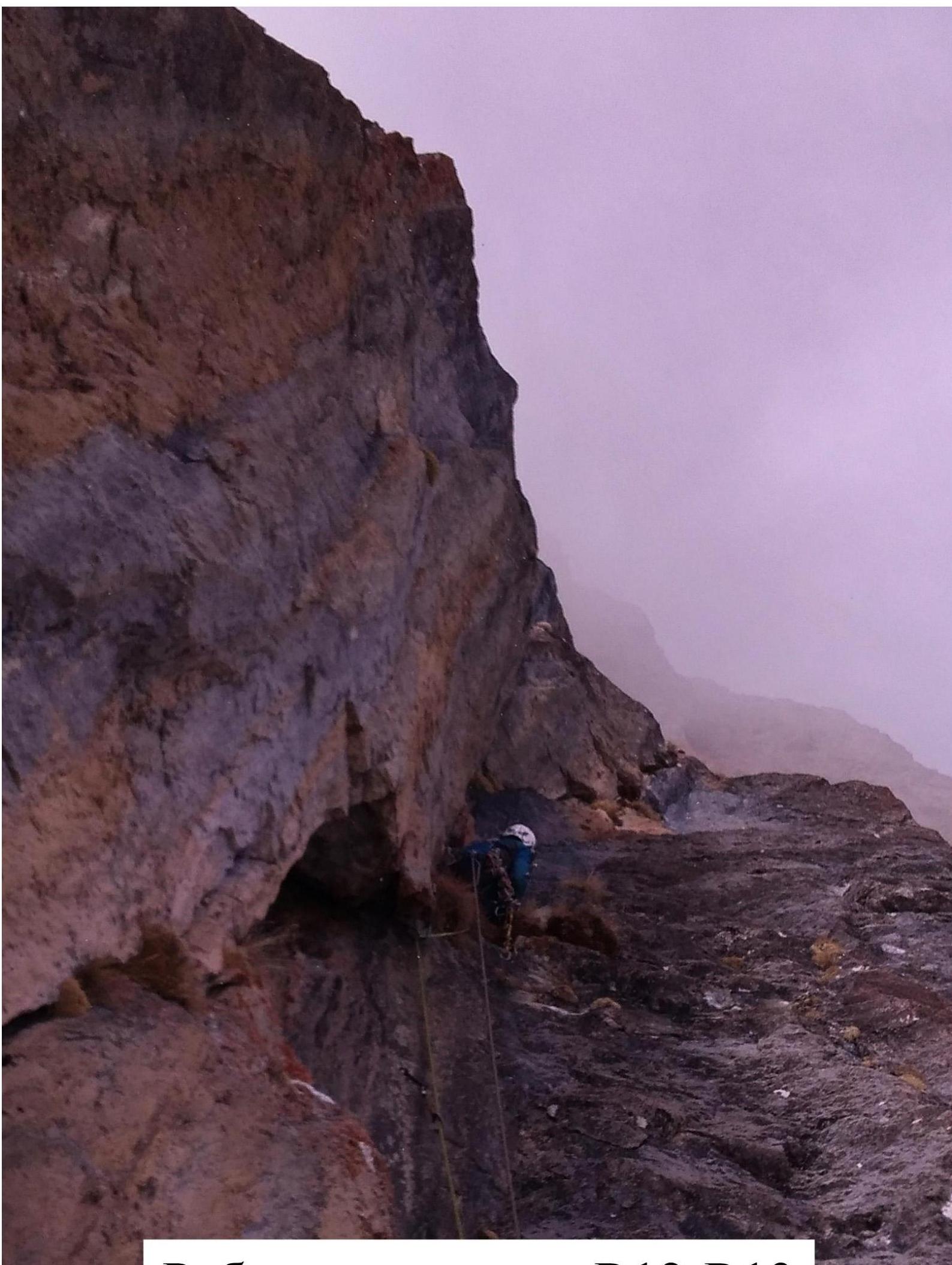
R18–R19. 25 m, 60°, VI, A1. Traverse left along a ledge and up a crack for about 10 m. Through an overhang up into the base of a large yellow internal corner. Semi-hanging station.
R19–R20. 60 m, 90°, VI, A2. A large vertical internal corner, sometimes overhanging, with thin cracks and fissures. Many "live" stones. Passage requires attention as falling debris can hit other team members.
R20–R21. 40 m, 75°, VI, A1. From the station up continue along the corner to a white patch on the right wall, where a piton with a loop is hammered to dampen a pendulum. Intermediate station possible. Traverse left along a crack with grass tufts and up into the base of a hanging yellow-white wall with a central crack. Hanging station. An anchor piton with a carabiner is left for pendulum damping.
R21–R22. 50 m, 110°, VI, A3. KEY SECTION. Up the crack in the hanging wall on ITO. Crack walls are crumbling, so thin drawn cracks are used alongside the main crack. The strong overhang makes this section slow and laborious. Midway, due to poor relief:
- 2 pitons were drilled for protection (ears twisted);
- several steps were made on holey skyhooks on the overhang. Exit over a ledge to a rib on the wall. Station on the ledge. The third participant, leaving R21, swung 15 m from the wall.
R22–R23. 50 m, 50°, III. Up a small wall onto a rib. Along the rib up through a series of inclined walls onto a ledge, near the exit of Dorro K.'s 6A route. Then a small pendulum down left about 10 m, into a snow couloir.
R23–R24. 370 m, 35°, I. Up a simple scree slope towards the summit.
R24–R25. 100 m, 45°, I. Through large boulders onto Gaikomd (Kyazi) Main, 3171 m.
Descent via a category 2A route.
Gaikomd (Kyazi) Main Peak – 3171 m
January 29, 2018, 4:19 PM
Gaikomd (Kyazi) Main summit, 3171 m, R25
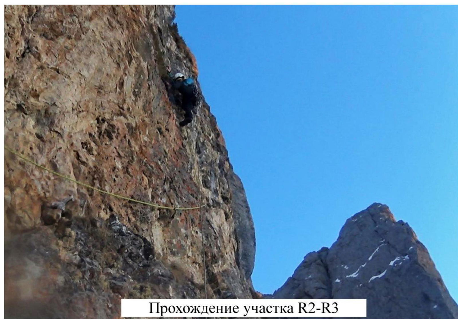
Passage of R2–R3 Section
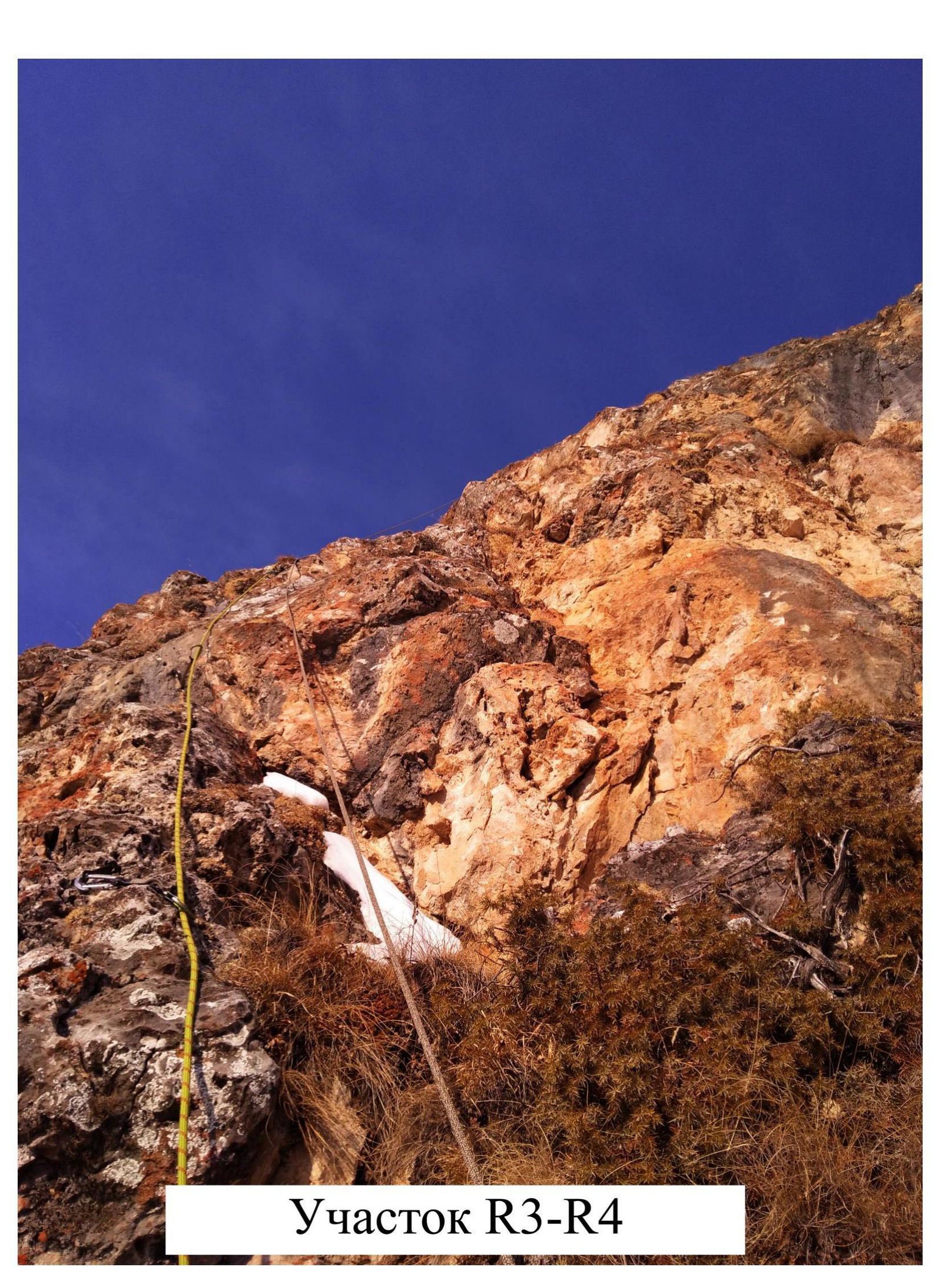
R3–R4 Section
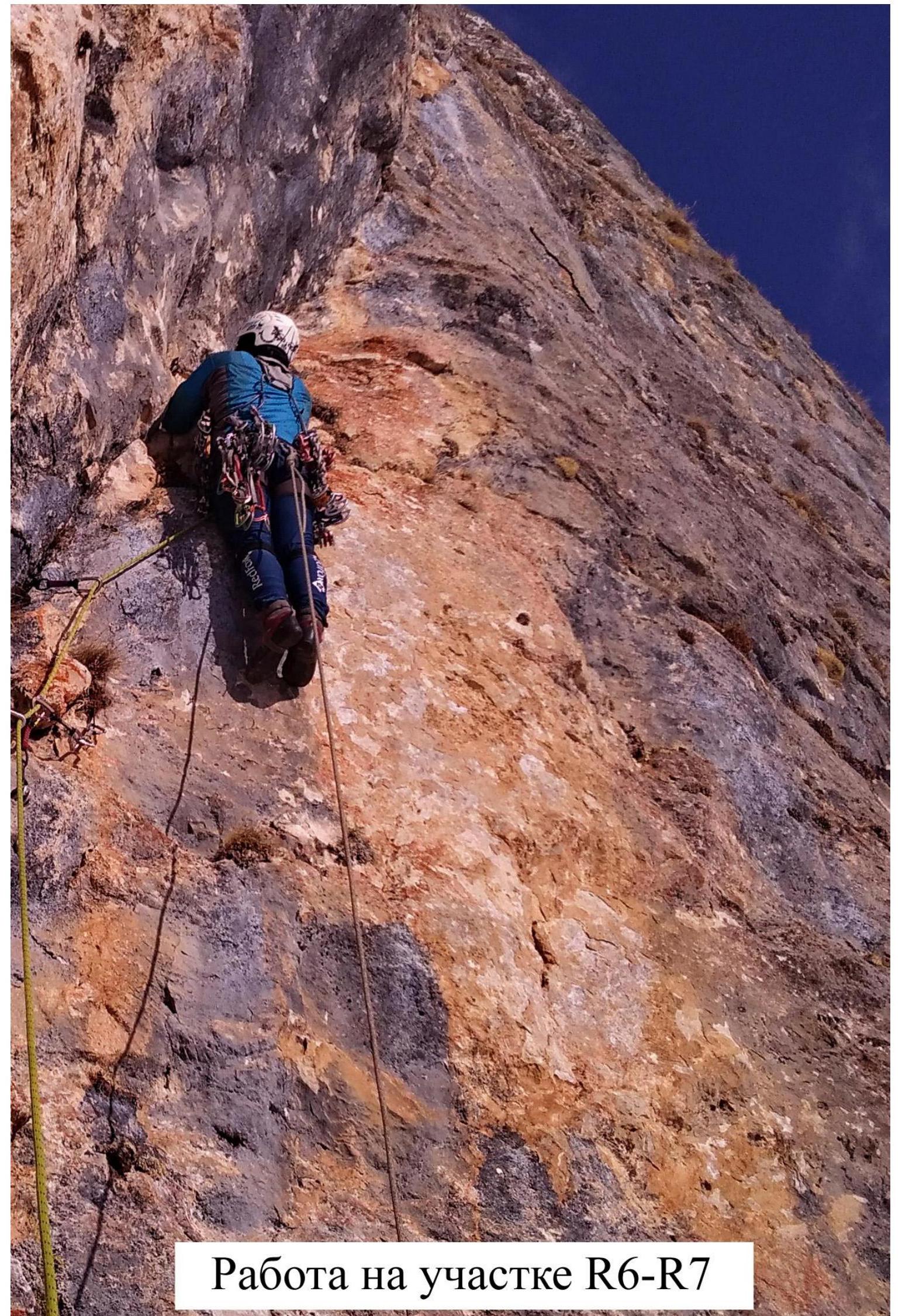
Work on R6–R7 Section
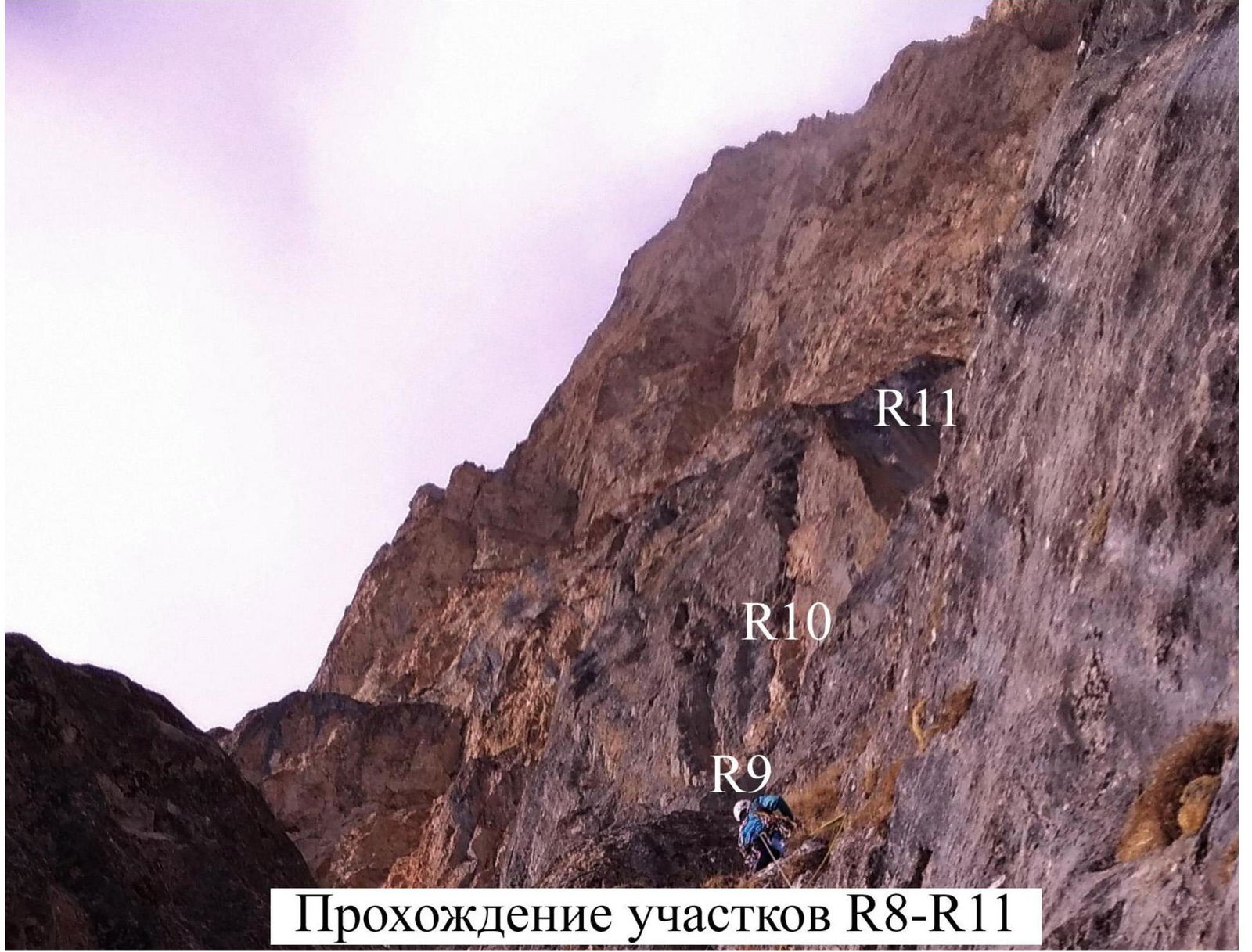
Passage of R8–R11 Sections
R11–R12 Section
Work on R12–R13 Section
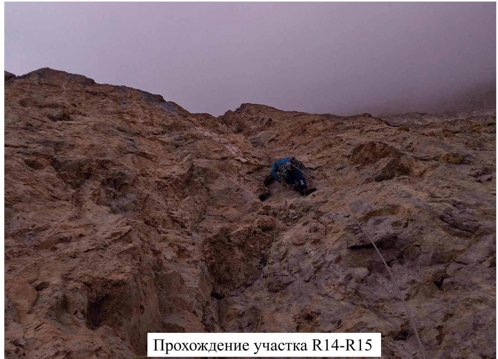
Passage of R14–R15 Section
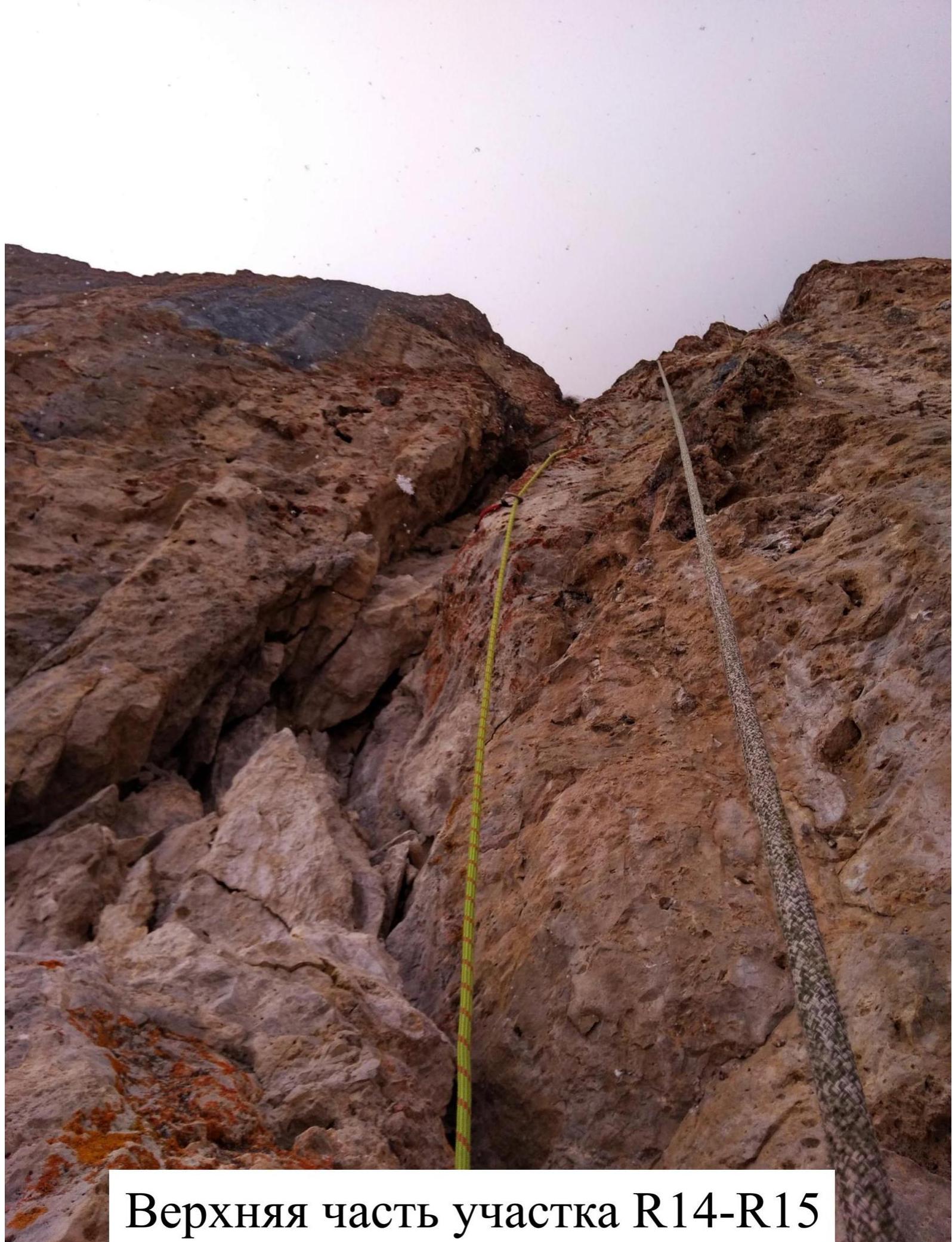
Upper part of R14–R15 Section
Passage of R16–R17 Section
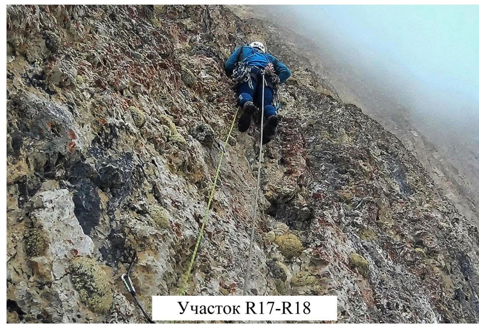
R17–R18 Section

Leveling the ledge for bivouac on R18. Bivouac in a tent on January 28–29, 2018.
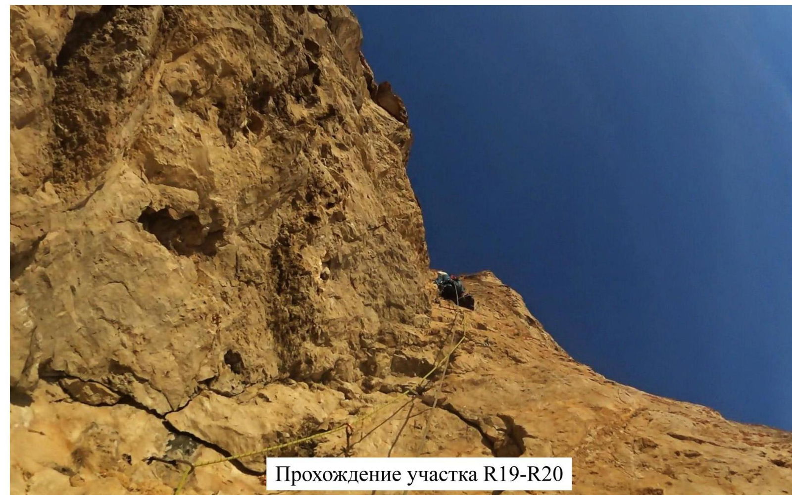
Passage of R19–R20 Section
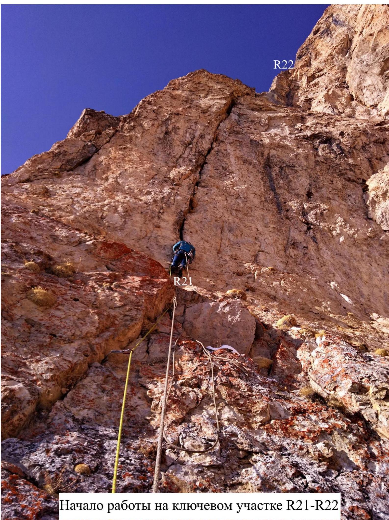
Start of work on key R21–R22 Section
R19–R21 Sections. View from above, with a rope.
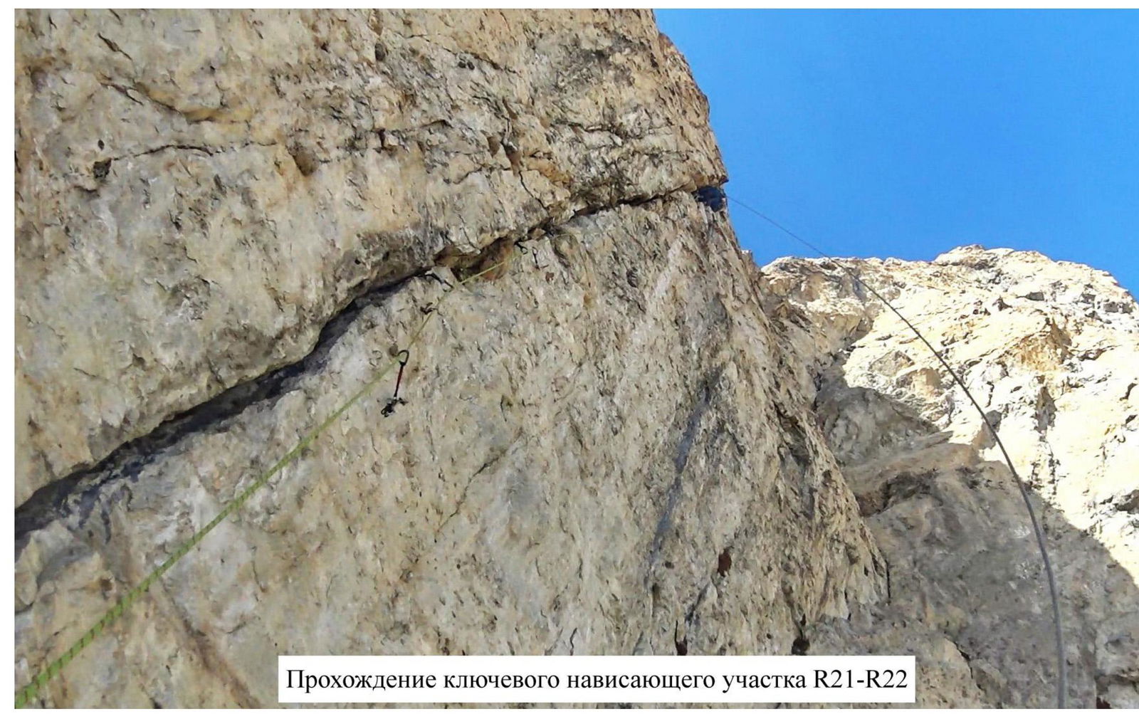
Passage of key overhanging R21–R22 Section
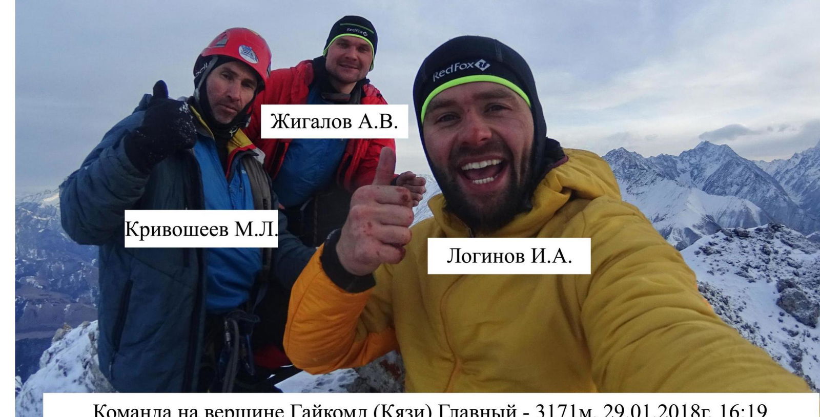
Team on Gaikomd (Kyazi) Main summit, 3171 m, January 29, 2018, 4:19 PM
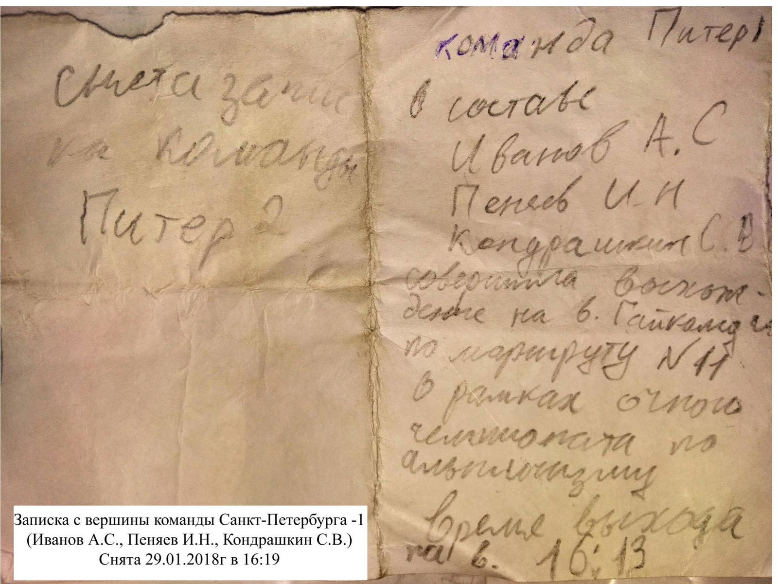
Note from St. Petersburg team – 1 (Ivanov A.S., Penyaev I.N., Kondrashkin S.V.). Taken on January 29, 2018, at 4:19 PM.