
PASSPORT
-
Class — rock
-
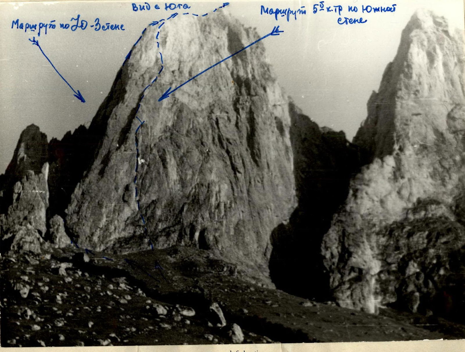
Eastern Caucasus, Skalisty Ridge, Armkhi gorge, ChIASSR
-
Giphyroch Glavnaya peak 3171 m, via the southwestern wall (see appendix 2)
-
Proposed 5B category of complexity, first ascent
-
Height difference: ≈ 500 m ≈ 510 m Length: 555 m – 565 m Length of sections with 5–6 category of complexity: 390 m – 400 m Average steepness of main sections: 50–60° (485 m) Of which 6 category of complexity — 85 m (85°)
-
Pitons driven: Rock: 127 Bolt: 11 Chocks: 6 Ice: none
-
Team's travel time: 21 hours (not including descent) and 3 days
-
Overnight stays: 1 — on an inclined rock shelf 2 — on the summit
-
Leader: Vladimir V. Gorin, Candidate Master of Sports of the USSR Participants: Alexander V. Rasskazov, Master of Sports of the USSR Alexey P. Negodyaev, 1st sports category Abduslam M. Amirkhanov, 1st sports category
-
Coach: Yuri I. Porokhnya, Honored Master of Sports of the USSR
-
Start of the route: July 10, 1983 Summit: July 11, 1983 Return: July 12, 1983
Different editions of maps give the following names for the object of ascent: "Gaikomd" (1943 edition) "Gir-choch" (1965) "Giroch" (1965), but the transcription of the local name corresponds more to the name "Giroch" (toponymic dictionary, vol. 2, "Grozny Worker" publishing house, 1980)
In connection with this, the team adopted the name "Giroch" for the peak.
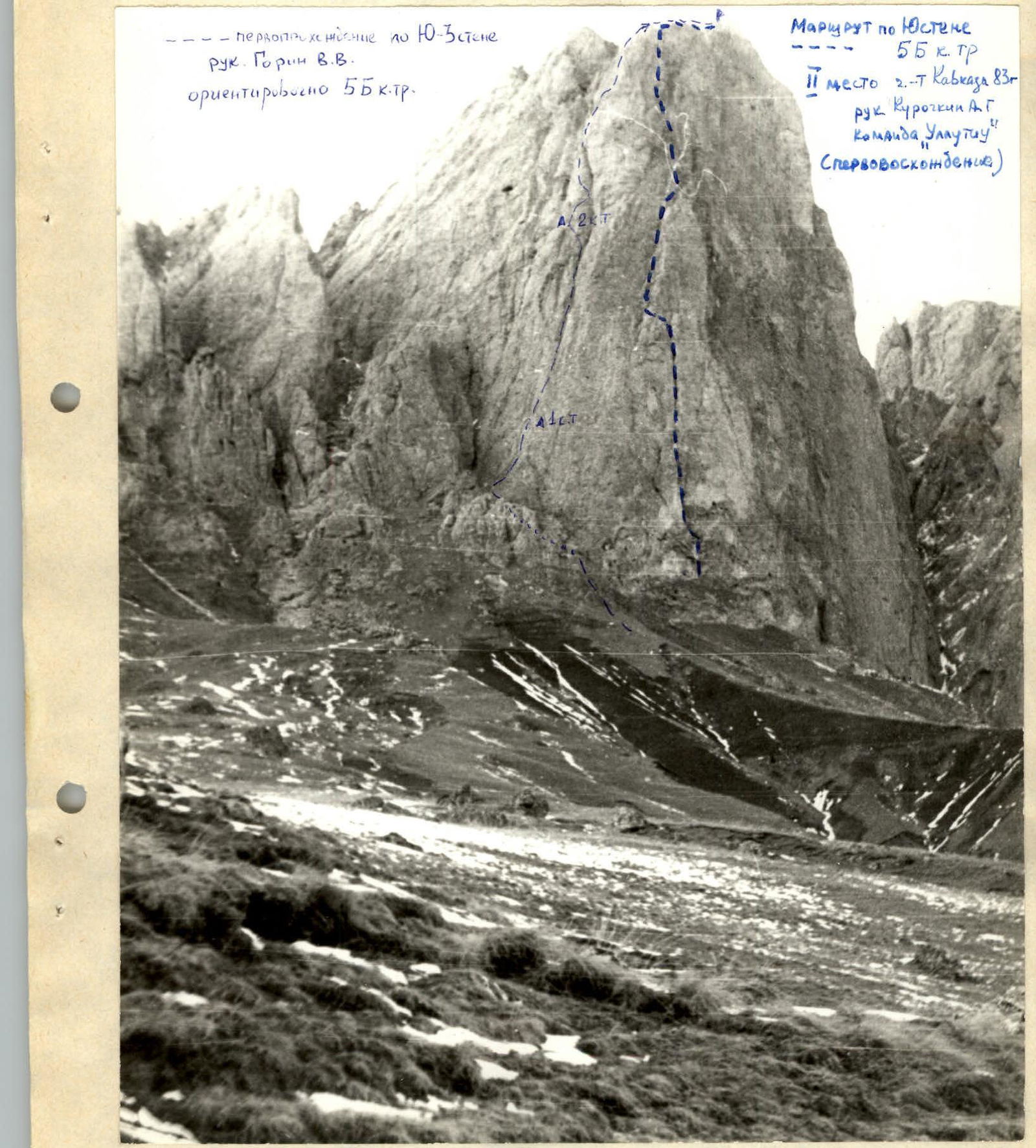
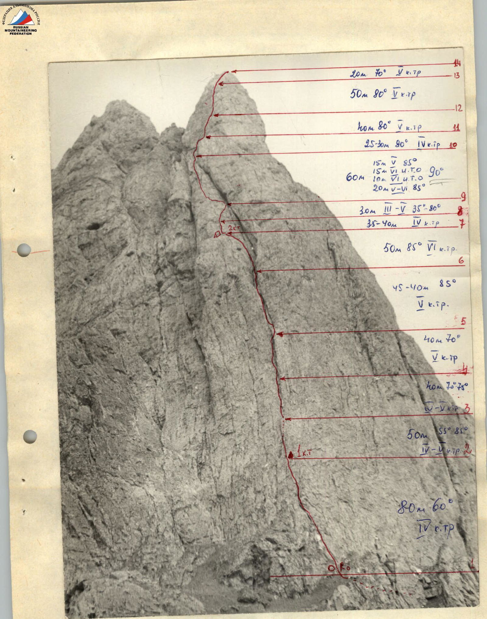

Route diagram in UIAA symbolism, scale 1:2500
Tactical actions of the team.
July 10, 1983
At 6:00, the team left the bivouac under the start of the route, and the Rasskazov—Negodyaev pair began work on the lower part of the route. They covered 50 m of easy rock with grassy ledges, then attached another rope and climbed another 30 m to organize a fixed rope anchor point (control cairn). The path then followed a chimney, which they climbed for 4 pitches (160 m), with Rasskazov leading and organizing fixed ropes for the rest of the team to follow. At section R6–R7, the team exited the chimney, ascending its left, sheer, reddish wall to a large inclined ledge, where they spent the night (exit time — 16:30) and built a 2nd control cairn. They hung another rope upwards.
July 11, 1983
At 9:00, the Rasskazov—Gorin pair began work on the route, climbing the rope hung the previous day and then another 30 m to the right and upwards to an inclined ledge. From there, Rasskazov, belayed by Gorin, began to climb a 50-meter wall (R9–R10), initially with few cracks and holds, then monolithic (bolted), and at the top, transitioning into a sheer wall with a poorly defined crack. After that, an internal corner (R10–R12) led to a large, wide ledge, where the entire group assembled. Climbing another 3 pitches (R11–R14), the group reached the pre-summit tower, from which they moved towards the summit along the left, scree-covered part of the ridge, reaching the summit at 19:00. Continuing along the ridge, on a scree-covered shoulder, the group spent the night.
July 12, 1983
At 9:00, the group began moving down the ridge and then descended via a category 1 route, followed by grassy slopes towards the trail leading to the corral, which they reached at 13:00, returning to the base camp.
Description of the route by sections.
From the initial bivouac in the base camp near the upper corral, it takes about 1 hour to ascend a steep, grassy slope under the southern wall. Traversing the slope under the wall to the left towards a large rock couloir, with a large gendarme on the left, and ascending via the couloir (rocks resembling "ram's foreheads") to 150 m below the base of the 10-3 wall. The route on the wall is bounded by two enormous chimneys converging at the top, and in the lower part, it follows the right-hand chimney. At the start of the route in the couloir, a cairn is built as a landmark.
From the cairn, ascend directly up the wall for 80 m (R1–R2) via category 4 rocks with grassy ledges and walls with "loose" rocks (5 rock pitons) to a small ledge accommodating 2–3 people, where a 1st control cairn is suspended on a bolt.
From the ledge, ascend the wall about 17 m, category 4 rocks, 50–55°, to a small shoulder. From the left part of the shoulder, a chimney (about 25 m) with sheer walls of category 5 complexity (piton belay — 3 rock pitons and 1 chock) leads upwards, ending in a small scree-covered shoulder, above which lies a stepped wall of category 4, 80°. After climbing another 8–10 m, one can establish a belay (section R2–R3).
From the end of the belay, another 8 m along the stepped wall, bypassing a small ridge on the right where it approaches the wall, transition into the start of the R1,3–R4 chimney. Ascend this (category 5 rocks), with the chimney floor inclined at 70–75° and walls at 80–85°, to the end of the rope. Then continue up the chimney for 40 m (R4–R5) to its overhanging section. Ascend the left, and occasionally right, part of the chimney, with sheer walls and few holds. From the final point of the section (R4–R2, a large niche in the chimney), ascend 5 m up the left, sheer wall of the chimney and then continue up the chimney (R5–R6) to its upper part (wet rocks) with a large overhanging stone. Bypass this on the right, leaving it on the left, and exit onto a scree-covered ledge ("loose" rocks), from which the chimney continues upwards (60 m), 8–10 m wide.
From the ledge, ascend left and upwards (R6–R7) via the left, sheer wall of the chimney (reddish rocks with few holds) for 50 m (R8–R9 pitons) to a large rock ledge, where a 2nd control cairn is built. The ledge can accommodate an overnight stay; it is a large, monolithic, slightly inclined slab. From the ledge upwards lies the upper, triangular part of the wall, bounded by two converging chimneys.
Ascend from the 2nd control cairn 40 m upwards (R7–R8) (3 pitons) via rocks resembling a destroyed internal corner, category 4, with "loose" rocks, to a small ledge accommodating 2–3 people under the base of a slab-like wall section. From here, ascend via the right part of the wall (R8–R9), along slabs (category 5, 80°) for 25 m to an inclined ledge (30°, category 3), leading into the upper part of the right-hand chimney under an overhang. From the middle of the ledge, ascend 20 m via slabs with very few holds (difficult climbing, category 6, 70–75°) to a smooth part of the wall ("mirror"), and then another 6 m with artificial aids (5 bolt pitons, ladders) to the base of a sheer crack (8–9 m), which is climbed using ladders (3 rock pitons, 1 bolt) and leads into a destroyed internal corner (15 m, 60°, category 5), where a belay can be established. This section (R9–R10) is the key section of the route.
Then, ascend via the internal corner, consisting of blocks with many "loose" rocks (section R10–R11, 25 m, 80°, category 4), to a long, wide ledge where an overnight stay can be organized. From the ledge, ascend directly to the pre-summit tower via 2 pitches (40 m and 50 m), category 5 rocks, 80°, with piton belays. Continue via an internal corner (20 m, 70°, category 5) of smooth slabs to the top of the pre-summit, marked by a large stone (section R11–R14). At this point, the wall section of the route ends. Continue simultaneously, staying on the left, scree-covered part of the ridge towards the summit.
From the summit, descend via scree, moving northwards, crossing 3 scree-filled couloirs in the upper part, and then follow a distinct descent trail, initially scree-covered and then grassy, down to the trail leading to the corrals, and then to the base camp.