Ascent Passport
- Ascent category — ROCKY
- Ascent region — East Caucasus, Shavana ridge
- Peak, its height, route — Salgi peak, 3961 m — via S ridge.
- Route characteristics: a) height difference — 700 m. b) route length — 1900 m. c) average steepness of the route — 40°
- Pitons hammered in for belaying (I.T.O.): rock — 10/2 ice — – bolt — –
- Number of travel hours on the route: to the summit — 7 hours.
- Number of nights and their characteristics: NONE
- Proposed category difficulty — 2A
- Full name of the leader, participants, their qualifications:
- Pyltsin V.N. — CMS.
- Ivashkin V.V. — CMS.
- Logovskoy V.I. — CMS.
- Nedyuzhev E.I. — 1st sports category.
- Team coach: Vasilenko A.A.
- Dates of departure for the route and return to the base camp: a) departure on the route — October 3, 1984. b) reaching the summit — October 3, 1984. c) return to the base camp — October 3, 1984.
Description of the Ascent Region
The ascent object is located in the Eastern Caucasus, in the southern part of the ChIASSR, in the Shavana ridge.
The ascent object is located in the center of the Shavana ridge, which separates the gorges of the Kistinka and Shan-don rivers.
This ridge contains the peaks:
- Shan (4451 m)
- Dzeneladze (4400 m)
- Rustavi (4350 m)
- Kichchechkort (4133 m)
- and others.
Routes have been laid to the peaks of this ridge (from the Kistinka gorge side) from 1 to 4B category difficulty.
No ascents have been made from the Shan-don river gorge side.
At the 21st km of the Military Georgian Road, the Terek river is joined by its left tributary — the Armkhi river. The road leads to the village of Armkhi (12 km) — there are regular buses from the city of Ordzhonikidze.
From the village of Armkhi upstream along the Armkhi river to the confluence with the Shan-don river (about 2 hours walk).
Further upstream along the Shan-don river (direction — to the South). The gorge is covered with forest, good trail.
At the forest boundary near the lakes (2071 m) — base camp; from the village of Armkhi — 6–7 hours.
From the base camp to the eastern cirque of the Kiggeg-kort — Salgi peaks:
- Path along the wide couloir-slope of the left bank of the Shan-don river.
- Ascend to the East Kig glacier.
- The glacier is covered with moraine.
- Overnight stay under the East ridge of the Kichchechkort peak near a large "reddish" rock (3200 m).
- Water in a glacier crevice.
From the base camp to the overnight stay — 5–6 hours.
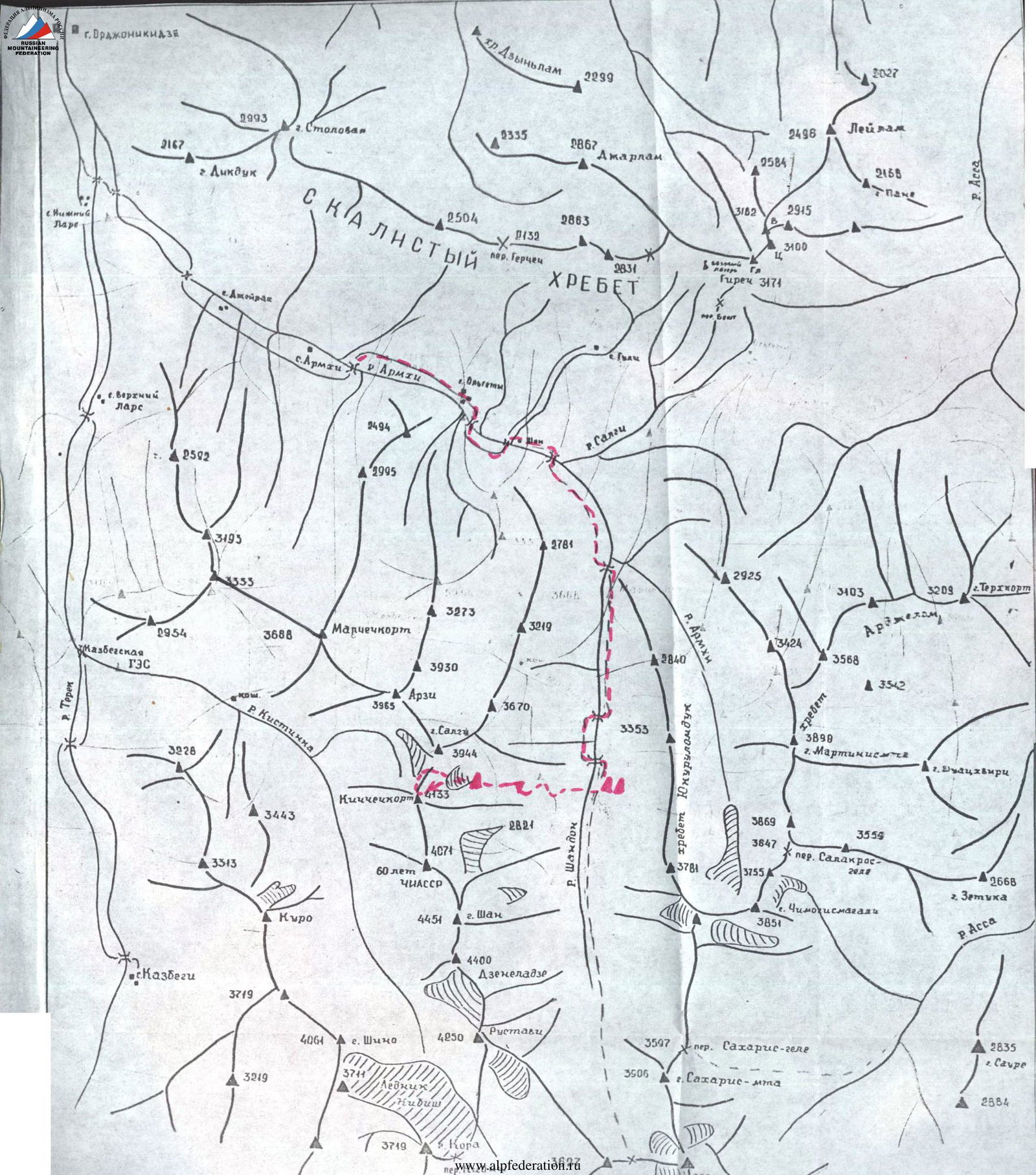 Photo 1. General view of Salgi peak
Table of Route Participants
| Grid section designation | Average steepness | Section length (m) | Relief characteristics | Difficulty | State | Rock pitons | Ice pitons | Bolt pitons |
|---|---|---|---|---|---|---|---|---|
| 1 | 25° | 800 m | Snow-ice slope | I | Ice covered with snow | – | – | – |
| 2 | 40° | 500 m | Scree couloir | I | Small frozen scree | – | – | – |
| 3 | 65° | 150 m | Scree couloir | II | Couloir with rock outcrops, snowy "plug" at the pass | 1 | – | – |
| 4 | 80° | 35 m | Rocky ridge wall | III | Monolithic rocks of the Gendarme | 4 | – | – |
| 5 | 90° | 10 m | Rocky wall | IV | Monolithic rock wall 3/2 (I.T.O.) | – | – | – |
| 6 | 45°–50° | 100 m | Rocky ridge | II | Monolithic rocks of the ridge (snow-covered) | – | – | – |
| 7 | 70° | 8 m | Bypassing the Gendarme on the left along the ice slope | III | Flow ice on an inclined rocky shelf | 2 | – | – |
| 8 | 50° | 400 m | Rocky ridge | I–II | Destruction of the rocks of the pre-summit ridge | – | – | – |
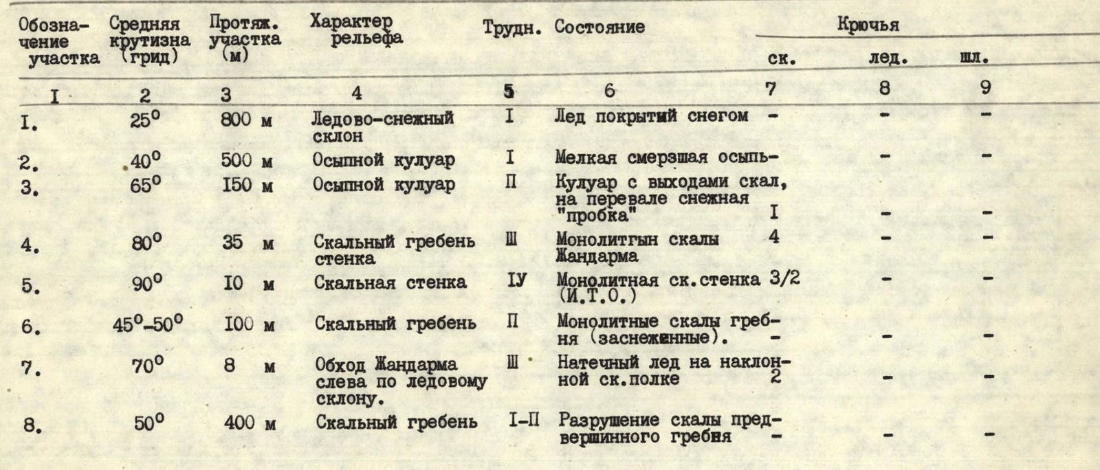
Travel hours to the summit — 7 hours.
Descent via the NE ridge.
 Photo 2. Technical photo of the route.