Ascent Passport
I. Ascent class — Combined 2. Ascent area — East Caucasus, Shavana ridge 3. Peak, its height, route — p. Kichchechkort, 4133 m, via North-Eastern buttress of Eastern ridge. 4. Route characteristics: a) height difference — 900 m. b) route length — 1500 m. c) average steepness of the route — 50° 5. Pitons hammered for belay (I.T.O.): — rock — 14 — ice — — bolt — 6. Number of walking hours on the route: — to the summit — 10 h 7. Number of overnight stays and their characteristics: none 8. Proposed category of difficulty — 2B cat. diff. 9. Full name of the leader, participants, their qualification:
- Pyltsin V.N. — CMS
- Vdovychenko V.I. — 1st sports category
- Govorov S.S. — 1st sports category
- Mintuev Kh.Ts. — 1st sports category
Team coach: Vasilenko A.A. II. Date of departure on the route and return to the base camp: a) departure on the route — October 5, 1984 b) reaching the summit — October 5, 1984 c) return to base camp — October 5, 1984

General view of p. Kichchechkort (4133 m)
Route Description
on p. Kichchechkort via North-Eastern ridge, 2B cat. diff.
From overnight stays near the large "reddish" rock, up the East Kichchechkort glacier in the direction of steep smoothed rocks of the indistinct NE buttress of the Eastern ridge. Bypass the smoothed rocks on the right along the glacier, overcome the bergschrund and exit onto the rocks of the buttress from the right side (section 1).
Further, 40 m up-left along steep destroyed shale rocks and exit onto the talus ridge of the buttress (section 2) (alternate belay).
Along a gentle talus ridge, overcome small rock walls head-on (cautiously, "live rocks"), move 200 m in the direction of rock gates formed by two reddish characteristic rock gendarmes (section 3).
Then up the rocks of medium difficulty, smoothed and icy, with an exit from the right side to the top of the left rock of the rock gates.
Control turn. From here up 20 cm along the ice-snow slope on the right side of the ridge to white-colored rock slabs (section 5). Steep rock slabs (10 m) — the key section, are overcome along the central crack (pitons belay) with an exit to a convenient ledge in the upper part (section 6).
Further along the right side of the ridge of the buttress, along alternating steep rock sections and talus ledges, exit onto a narrow isthmus of the buttress (section 7). From here, along the snow slope on the right side of the buttress, and then along the Eastern ridge, bypassing gendarmes on the right, exit onto the pre-summit isthmus of the Eastern ridge (section 8).
Then along the wide snow ridge, exit onto simple rocks and along them to the summit (section 9). Descent along the Northern ridge to the pass and descent down to the glacier to the overnight stay site.
Route Sections Table
| Section designation | Average steepness (degrees) | Section length (m) | Relief character | Difficulty | State | Rock pitons | ice | bolt |
|---|---|---|---|---|---|---|---|---|
| 1. | 30° | 200 m | Ice-snow slope | I | Thin layer of snow on ice | - | - | - |
| 2. | 75° | 90 m | Rock wall | III | Destroyed rocks | 6 | - | - |
| 3. | 40° | 200 m | Rock ridge of buttress with small walls | II | Destroyed rocks | 1 | - | - |
| 4. | 65° | 30 m | Inner corner | II | Smoothed icy rocks | 2 | - | - |
| 5. | 45° | 20 m | Snow slope | I | Hard firn | - | - | - |
| 6. | 80° | 10 m | Rock wall | III | Slab with an oblique crack in the middle | 3 | - | - |
| 7. | 70° | 80 m | Rock wall with talus ledges | II | Destroyed rocks with talus inclined ledges | 2 | - | - |
| 8. | 55° | 260 m | Snow slope | II | Hard firn | - | - | - |
| 9. | 60° | 660 m | Snow ridge in the upper part rocks | I | Hard firn | - | - | - |
Walking hours to the summit — 10 h. Descent along the Northern ridge.
Description of the Ascent Area
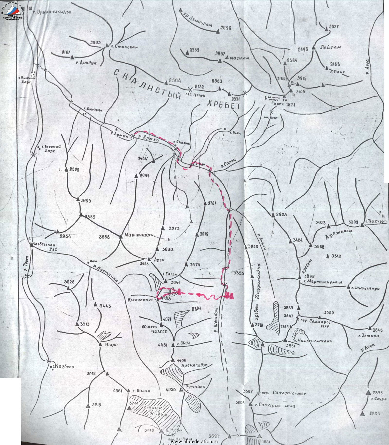
The ascent object is located in the Eastern Caucasus, in the southern part of the ChIASSR, in the Shavana ridge.
The ascent object is located in the center of the Shavana ridge, dividing the gorges of the Kristinka and Shan-don rivers. In this ridge are located peaks Shan (4451 m), Dzeneladze (4400 m), Rustavi (4350 m), Kichchechkort (4133 m), and others. Routes have been laid to the peaks of this ridge (from the Kristinka gorge side) from 1 to 4B cat. diff. From the Shan-don river gorge side, ascents had not been made before.
At the 21st km of the Military Georgian Road in the settlement of Terek, its left tributary — the Armkhi river — flows into it. The highway leads to the village of Armkhi (12 km). There are regular buses from the city of Ordzhonikidze.
From the village of Armkhi upstream along the Armkhi river to the confluence with the Shan-don river (about 2 hours walk).
Further upstream along the Shan-don river (direction — south), the gorge is covered with forest, good trail.
At the forest boundary near the lake (2071 m) — base camp. From the village of Armkhi to the base camp — 6–7 hours.
From the base camp to the eastern cirque of the Kichchechkort–Salgi peaks, the path along the wide couloir-slope of the left bank of the Shan-don river rises to the East Kichchechkort glacier. The glacier is covered with moraine.
Overnight stay under the Eastern ridge of p. Kichchechkort near the large "reddish" rock (3200 m). Water in a glacier crevasse.
The path from the base camp to the overnight stay — 5–6 hours.
6. Kuzerzopt (4183 m)

Photo 2. Technical photo of the route.