
Ascent Passport
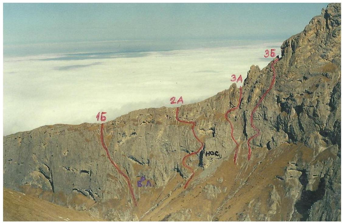
- Caucasus; Rocky Range; Classification section number - 2.8.
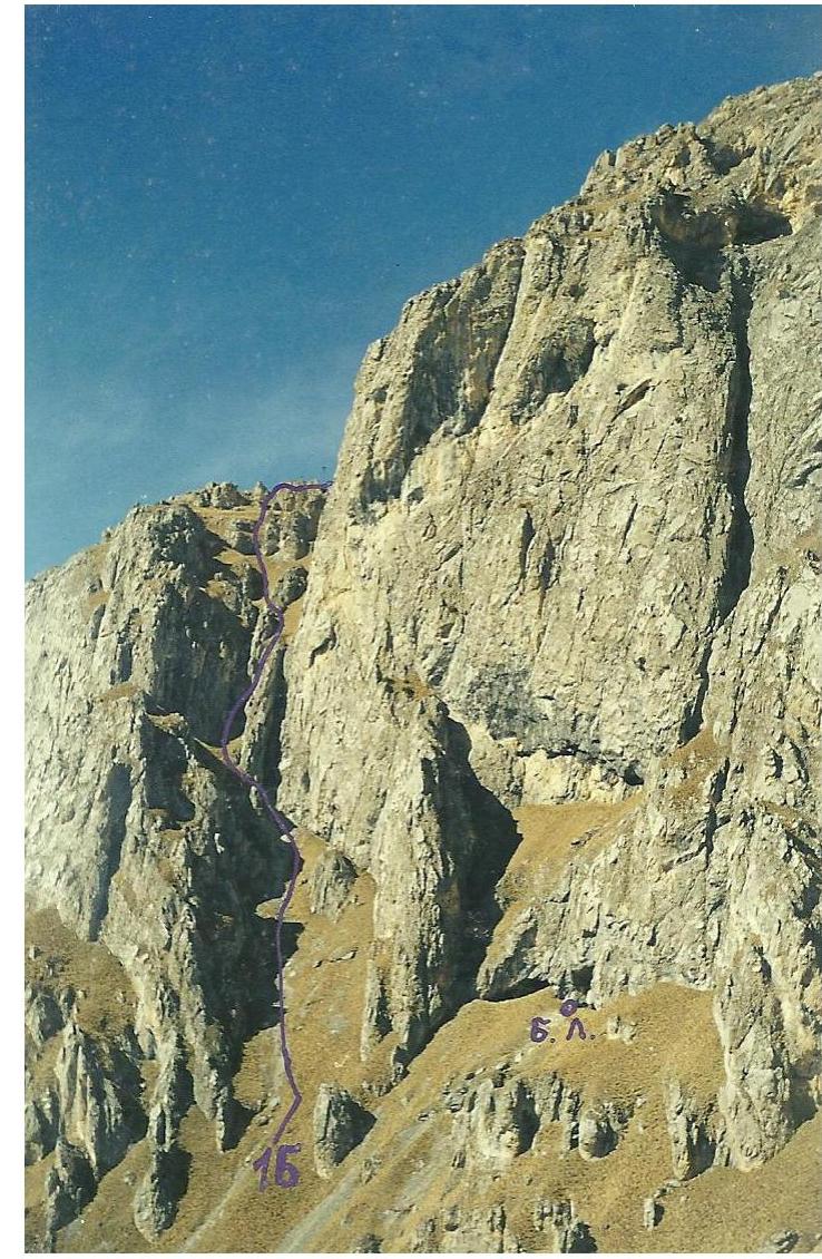
- Tbau (C-3) – 2980 m; from the south along the North-West ridge.
- 1B category of difficulty; first ascent.
- Nature of the route – rocky.
- Route elevation gain – 700 m.
The length is about 2200 m. The elevation gain of the wall part of the route is 200 m. The steepness of the key sections of the route is up to 60°. The average steepness of the entire route is 30°.
- Pitons left on the route – none.
- Team's walking hours – 5 hours, days – 1.
- Leader: Egorin Sergey Vladimirovich – Master of Sports Participant: Gagiev William Taymurazovich – 3rd sports category
- Coach: Egorin S.V. – Master of Sports
- Departure to the route: April 14, 2001 Summit: April 14, 2001 Return to base camp: April 14, 2001
Brief Overview of the Climbing Area
The climbing area is located in the Republic of North Ossetia – Alania, between the Fiagdon River to the west and the Gizeldon River to the east. The Tbau massif is situated in the Rocky Range and stretches for more than three kilometers from west to east.
The rocks forming the Tbau peak are of sedimentary origin – limestones, dolomites, and locally marble. Like most peaks of the Rocky Range, Tbau is a typical escarpment, i.e., it has relatively gentle northern slopes and steep, walled southern slopes.
Previously, this peak was only accessed from the south and southeast from the villages of Kakadur and Fazikau via a non-categorized route. Sport climbing in the massif began only 7 years ago. In particular, the Southwest wall of Northwest Tbau was explored. Categorized routes on Tbau East are possible in the future.
Among the Ossetians of the Dargavs gorge, the Tbau peak is considered sacred; according to legend, it is the abode of Tbau-Uats-Ila (St. Elijah of Tbau mountain). To this day, every June, the villagers of Dargavs celebrate a festival in his honor.
Approach to the Route Description
From Vladikavkaz, take a bus to Kharisdzhin, through the Kurtatinsky gorge to the "Metallurg" pioneer camp. Cross the Fiagdon River by bridge and ascend via a dirt road from the water pumping station. Passing through a forest and two clearings, you enter the beginning of the gorge (onto its right slope as you proceed), which leads under the Southwest walls of Tbau. Ascend via an old abandoned road through a beech forest. Continue on a trail that transitions to the left slope. It takes about 1.5 hours from the water pumping station.
After a steep ascent, exit the forest and continue up the gorge along grassy slopes. It's easier to walk above the forest under the rocky walls on the left. When the gorge narrows, descend to its bottom. Approach a narrow rocky canyon and navigate its bottom. Bypass a wall across the canyon on the right via moss-covered rocks (category 2-3 difficulty).
Continue along the canyon bottom, passing small walls, to reach the only spot in the gorge where water may be found during favorable conditions, especially in the off-season (a spring). Above and below this spot, the water disappears. Proceeding further along the canyon, exit onto its right slope as the gorge widens. Continue straight up the gorge to its fork. Turn left here and ascend via scree and a couloir towards the visible Southwest wall of Tbau (C-3). When the couloir transitions into a broad grassy slope with rock outcrops, turn left and ascend along the southern walls of the Northwest ridge of Tbau (C-3) peak. Pass a couloir that leads to the Northwest ridge (remaining on the left), and proceed straight up under the southern walls. Camping is possible in grottos here without tents. The elevation is 2300 m. The height gain from the water pumping station is 1300 m, and it takes 5-6 hours of walking. There's no water near the grottos; snow may be present from November to May.
Route Description
From the campsite, return to the base of the grassy couloir leading to the Northwest ridge. This couloir is the most pronounced passage in the southern walls of the Northwest ridge of Tbau (C-3) peak.
R0–R1: Ascend the couloir straight up to the first rocky step. About 200 m.
R1–R2: Overcome the first rocky step via a somewhat indistinct chimney, 5-6 m long, category 3-4.
R2–R3: After the chimney, approach the second rocky step via a 50 m traverse on a grassy-scree slope. Pass it straight up via ledges and small walls between them. About 20 m, category 2-3.
R3–R4: After the second rocky step, exit onto a grassy slope with rock outcrops and, in 200 m, ascend to the Northwest ridge.
R4–R5: Along the Northwest ridge, on its left side, approach the "Palezy" gendarme at the base of the right part of the northern slope of Tbau (C-3) peak. About 400 m.
R5–R6: Bypass the "Palezy" gendarme from below on the left, then ascend left-upwards via scree (or snow) slopes between rocky walls. The path follows scree terraces, ledges, or small couloirs. Proceed left-upwards to a small ridge, from which steep walls are visible further left. Turn right here. The entire path is category 1-2. In winter, there might be a significant amount of snow. The entire section is about 800 m.
R6–R7: Turn right and approach rocky slabs, possibly snow-covered, category 2-3. Ascend the slabs straight up, with ledges between them. Higher up, exit onto scree slopes. The length is about 100 m.
R7–R8: Continue moving left-upwards via scree or snow under the summit tower, bypass it on the left under the walls (small grottos, camping is possible), and exit under the Eastern slope of the peak. Category 1, about 300 m.
R8–R9: Ascend to the summit of Tbau (C-3) – 2980 m via the Eastern slope. First, follow a somewhat indistinct inner corner, then slabs. Category 1-2, about 100 m to the summit cairn.
From the campsite to the summit, it takes 5-6 hours. The descent via the ascent route takes 1.5-2 hours.
Conclusions and Recommendations for the Route
The route is logical and safe at any time of the year, with little snow on the northern slopes. It's recommended for training and sports groups. In terms of sports, it corresponds to its category of difficulty. With a proper tactical plan, the ascent can be completed in two days. It's crucial to follow the description exactly, both on the approach and on the route. Otherwise, one might encounter very difficult sections. On all sections of category 2 and above, use protection via rock features, as well as pitons and chocks.
Comments
Sign in to leave a comment