
Report on the Traverse of Peaks: Suatissi — p. Geologov — Jimaray — Shau-khok — Druzhba — Zaygelan
Team of the Central Council of the DSO "Krasnoye Znamya"
Coach NARKEVICH F.V. Captain PRAZDNIKOV V.A.
Minsk 1965

Scheme of the traverse of peaks "Suatissi — peak 4392 — Jimaray — Shau-khok — peak Druzhba — Zaygelan". Team of the Central Council of the DSO "Krasnoye Znamya", Minsk. Legend: visible path, invisible path, bivouac locations, route sections.
"It's better to quarrel with Kazbek than to drink tea with Jimaray" Ossetian proverb
"The Forgotten Mountains" is what they call the peaks of the Midrograbin glacier cirque. And this is true. Once popular peaks have been rarely seen with an alpinist's figure on their slopes over the last decade.
- Formidable Jimaray-khokh
- Beautiful Suatissi — the Caucasian Khan-Tengri
These peaks do not appear in reports of mountaineering groups and expeditions.
We find it difficult to determine the reasons for such unpopularity, but we can confidently say that the beauty and uniqueness of these mountains will remain in our memory for a long time.
Brief Geographical Description of the Climbing Area
The Midrograbin glacier area, surrounded by peaks, is located in the Lateral Range. The highest point is Jimaray-khokh (4776 m). Nearby stands the snowy head of the long-extinct volcano Kazbek (5047 m), and to the west stretch the pointed peaks:
- Tsyrbarzonda
- Teple-khokh
- Uilpaty-Tau
The virtually enclosed cirque of the Midrograbin glacier is oval-shaped, stretching from west to east. Almost in the center of the glacier rises the two-headed peak Khitsan-khokh, dividing the glacier into two parts: western and eastern. In the western part are located:
- Tsiti-khokh
- peak Gaponenko
- p. Resi
- p. Dinamo
- p. Pirogova
- Khirkhaten-khokh
- p. Donchenty
The eastern part of the cirque contains higher and more complex peaks:
- Tepli-khokh
- Midrograbin-khokh
- Suatissi
- Jimaray-khokh
- Shau-khokh
- p. Druzhba
- Zaygelan
In the western part of the cirque, there are passes:
- Resi (2A category of difficulty) — leads to the Terek river valley
- Jimarashka (1B) — through which one can reach the upper reaches of Fiag-don
The pronounced depressions in the ridge in the eastern part of the glacier are:
- Ten pass (2B) — leading to the Terek river valley
- depression in the ridge between v. Jimaray-khokh and Shau-khokh (Mininsky pass — 3A) — passing through which one reaches the source of the Genaldon river.
The area is characterized by powerful glaciation. Rock outcrops mainly consist of heavily destroyed dark shales, on which young volcanic lavas from andesites and dark basalts are often found. An exception is v. Tepli-khokh, composed of monolithic granite, its northern wall reaching 800 m. The glacier is generally characterized by a calm flow, but in the upper reaches, there are powerful crevasses covered with a thin layer of snow.
The traverse undertaken includes a group of peaks in the eastern "horseshoe" of Midrograbin:
- Suatissi (4473 m)
- p. Geologov (4392 m)
- Jimaray-khokh (4776 m)
- Shau-khokh (4680 m)
- p. Druzhba
- Zaygelan (4200 m)
The first part of the route (Suatissi — Jimaray-khokh) is characterized by powerful glaciation, while in the second half, heavily destroyed rocky relief prevails.
Climbing Conditions in the Area
The compact arrangement of peaks with the possibility of organizing a camp on the glacier plateau presents an excellent object for sports ascents for alpinists of 2nd and 3rd categories. The routes are mainly combined, with a predominance of ice and snow relief. However, the strong destruction of rocks requires increased vigilance and special training from participants. In addition to ascents from the glacier cirque, routes are possible from the Shtri-don river gorge and the Terek river gorge, although the approaches in these cases will be longer.
The weather in the Midrograbin area is highly unstable, as the high Kazbek-Jimaray massif serves as a significant obstacle to the penetration of subtropical air masses to the north and is a kind of moisture condenser, which often falls in the form of wet snow.
According to the Karmadon meteorological station:
- The driest and clearest weather is observed from October to March.
- The most rainy months are May, June, and July.
- The amount of annual precipitation exceeds 1000 mm.
Sometimes (5–15 times a year), rapid southern winds-fens occur. They sharply raise the air temperature, contributing to rapid snowmelt and avalanches. Fens act for several hours, but sometimes for one or two days. Often, fens end with significant cooling and precipitation. The strength of fens sometimes reaches more than 30 m per second.
The glacier plateau is often covered with dense fog, which comes through the gorge between the peaks Zaygelan and Donchenty from the Shtri-don river valley. During fog, visibility is reduced to 5–7 m.
The path to the climbing area begins from the city of Ordzhonikidze. The highway goes west to the village of Gizel, then turns south and enters a wide picturesque gorge carved by the Gizeldon river in the forested and pasture ridges. At the 18th km, the road branches: to the southeast — the Genaldon gorge, to the southwest — the Koban gorge. A simpler path goes along the Genaldon gorge through the Karmadon resort. However, we could not use it, as heavy rains in the mountains washed away the bridge across the Genaldon river, and we had to turn towards the village of Koban.
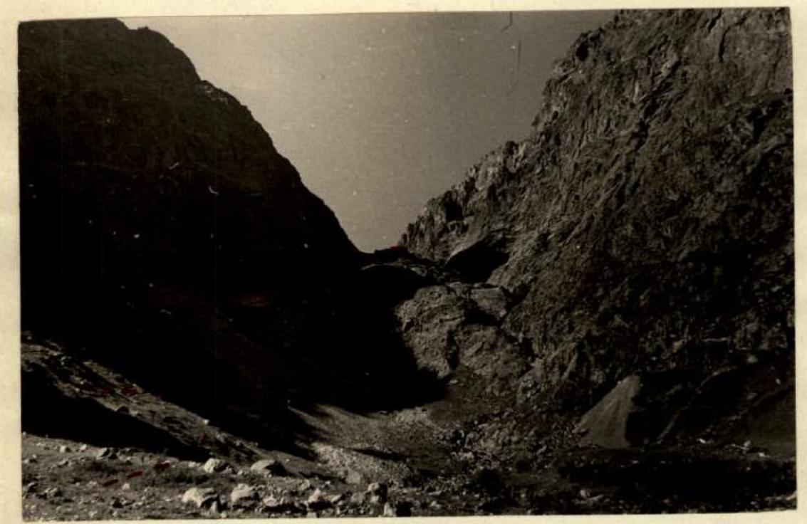 Gorge of the Midrograbin glacier. (----- path of movement).
Along this gorge, the car reaches the Gizeldon hydroelectric power station. There is no road further. We lift our equipment and supplies by cargo funicular to the top of the Dargavsky threshold. With great difficulty, we find a random car. The path then goes along the Gizeldon river through the villages of Dargavs and Jimara. Then along the right bank of the Shtri-don river, where there is practically no road, and only thanks to the driver's virtuoso driving skills do we reach the former G RP-81 (geological exploration party) settlement. From s. Jimara to G RP-81 is about 10 km. Here, the first base camp was organized.
The ascent to the Midrograbin glacier takes 4 hours. We go along the right bank next to the northern wall of v. Zaygelan. Sometimes an old trail is encountered. Then, overcoming a series of "ram's foreheads," we exit into the gorge of the Midrograbin glacier.
At the end of the glacier:
- We cross a steep snow bridge
- We move to the left edge of the glacier tongue
- Insurance is required in this section
Further:
- Partially between "ram's foreheads" and the glacier
- Partially along "ram's foreheads"
- We exit onto the glacier plateau
The main base camp is organized on the eastern slopes of the peak Khitsan-khokh.
Practically, the Midrograbin glacier area has not been visited for over 10 years. Approximately in 1950, a group of North Ossetian alpinists attempted to traverse the most difficult section of the eastern "horseshoe." But one of the main sections of the route was not completed by them (the ridge from Shau-khokh to p. Druzhba).
In subsequent years, individual ascents along simple routes were made by:
- Alpinists from Ordzhonikidze;
- Individual groups of geologists.
We did not find any literary materials on this area in the available literature. Significant consultative assistance in familiarizing ourselves with the area and individual routes was provided to the group by:
- The head of the CSP of the Tsey region, E. Grekov;
- The chairman of the alpinism federation of the SO ASSR, V. Kotov;
- Master of Sports in alpinism, Yu. Polyakov.
The cartographic materials available at present are far from perfect and require significant уточнения.
Organizational and Tactical Plans for the Ascent
The idea of organizing ascents for Belarusian alpinists in the Midrograbin glacier area arose in the winter of 1964. However, the lack of cartographic and reference materials required a significant period. Therefore, preparation was divided into several stages.
1st stage — reconnaissance and processing of cartographic materials.
In the summer of 1964, a group of mountain tourists, after completing the norms of the III sports category in alpinism at the "Torpedo" alpinist camp, was directed from Tsey through a series of passes to the Midrograbin glacier. Having reached the Resi pass, they managed to capture a panorama of the peaks, clarify the available scarce schemes of ridges and passes.
Through correspondence and personal contacts, descriptions and sketches of some peaks in the area were obtained. After processing, all materials on the area were systematized and replicated.
COMPOSITION OF THE MAIN GROUP (According to the application)
| № п/п | Surname, Name, Patronymic | Year of birth | Sports category | Alpinism experience | Place of work, position | Home address |
|---|---|---|---|---|---|---|
| 1. | PRAZDNICOV Vladimir Alekseevich | 1928 | MS | 1957 | Auto-building technical school — teacher | ul. Michurina, 12–7 |
| 2. | GRAKOVICH Valentin Fedorovich | 1939 | 1st sp. category | 1960 | Ordzhonikidze plant — engineer | ul. Vostochnaya, 95 |
| 3. | KASPAROV Konstantin Nikolaevich | 1932 | 1st sp. category | 1950 | AN BSSR — engineer | Leninsky pr., 53–106 |
| 4. | LOZOVSKY Leonid Ivanovich | 1938 | 1st sp. category | 1958 | Institute of Agriculture — research associate | ul. Kazenca, 113–3 |
| 5. | NARKEVICH Felix Vikentyevich | 1931 | 1st sp. category | 1950 | 1st Clinical Hospital — doctor | Leninsky pr., 78–46 |
| 6. | NOGOTOV Evgeny Fomich | 1939 | 1st sp. category | 1959 | AN BSSR — research associate | ul. Vostochnaya, 95 |
| 7. | SLEZIN Yuri Borisovich | 1935 | MS | 1954 | AN BSSR — senior engineer | ul. Volgogradskaya, 216–5 |
The traverse was completed by a group of six people. NOGOTOV E.F. was absent due to family circumstances.
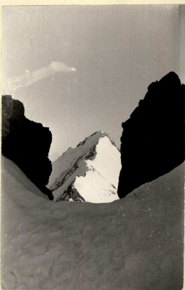
 Beginning of the ascent to the Tepli pass.
Route Description
1st day. July 29, 1965.
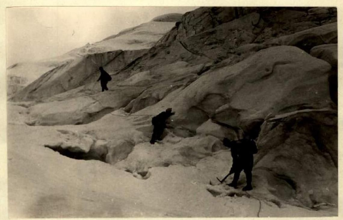
From the base camp located on the rocks under v. Khitsan-khokh, in the western part of the Midrograbin plateau, the path to the first peak of the traverse — Suatissi — goes along the Midrograbin glacier in an easterly direction. At the beginning of the path, the peak Suatissi is not visible; it is located in the southeastern corner of the Midrograbin "horseshoe" and is obscured by the peak Midrograbin. The glacier is gentle and safe, with a small number of small crevasses, but at the source, there are open and closed crevasses, and the steepness of the ice increases; here, it is necessary to move in crampons with alternate belay.
Bypassing the slopes of the peak Midrograbin, we begin to ascend to the southeast towards the foot of the peak Suatissi. The icefall descending from the Tepli pass, located in the ridge between the peaks Midrograbin and Suatissi, must be overcome in the middle part, as the left and right parts of the icefall are dangerous due to constant ice collapses and rockfalls from the slopes of v. Midrograbin. Having overcome the icefall, we turn southwest and ascend to the Tepli pass. At the beginning of the ascent, the slope is crossed by a wide and long crevasse, which we cross over a snow bridge in the narrowest part. The entire slope up to the Tepli pass is steep (40–45°) and covered with a thin layer of snow, the thickness of which decreases as we ascend. In some places, the snow is interspersed with sections of ice, where step-cutting is required. On the rocks of the Tepli pass, there is a cairn.
From the Tepli pass begins the ascent along the northwestern ridge to the peak Suatissi. At the beginning of the path, there are 200 m of a not very steep snow slope. Then, there is a section of steep shale rocks 150–200 m, along which we move carefully with alternate belay. Further, the ridge to v. Suatissi is firn, sometimes turning into ice, with a steepness of 40–45°. Movement along the ridge to the very top is impossible due to the presence of crevasses. This section is bypassed below the ridge along the southwestern slope in crampons. Having passed the section of crevasses, upon exiting onto the ridge, we overcome an ice slope 200 m with a steepness of 55°, requiring hook belay and step-cutting. The further path along the ridge to v. Suatissi does not present technical difficulties.
The cairn on v. Suatissi is located on a ridge of rocks, 20 m below the summit, in the direction to the southeast. We descend from v. Suatissi along the eastern ridge. The ridge is ice-snow, with a steepness of 35°, a height difference of 500 m, and cornices towards l. Midrograbin. During the descent from the summit, the weather begins to deteriorate, clouds appear, and a strong cold wind starts.
Gradually, the ridge becomes gentler towards the saddle and then turns into the slopes of the peak "4392" (p. Geologov). On the saddle, on the rocks, there is a cairn. We leave a note in the cairn, rest for 1 hour, and brew tea.
The ascent to the peak "4392" goes along an ice-firn slope with crevasses and cornices hanging towards l. Midrograbin. On the slopes of the peak, there is a cairn.
From the peak "4392" (p. Geologov) — so named in the note left on it — we descend along the northeastern ridge. The ridge is ice-firn, with a steepness of 45°. With small differences in height, 100 m is lost in this section. Further, for 600 m, there is an almost horizontal ridge to the southwestern slope of v. Jimaray-khokh. The ridge is very sharp, with cornices hanging on both sides. On the first 200 m, cornices hang to the south, and it is necessary to move below the cornices along the northern ice slope with a steepness of 50°.
2nd day. July 30, 1965.
After an overnight stay, we move along the ridge with cornices hanging to the north; for 150 m, it is necessary to move along the southern slope (50°) below the cornices. The tracks of the reconnaissance duo are hidden under a thick layer of snow. Further, the ice ridge is interrupted by a rocky ridge, representing a series of "gendarme" formations made of very destroyed shale rock, which are overcome either directly or bypassed from the right with great caution and thorough belay. After the rocks, another 150 m of the ice ridge with cornices hanging to the south lead to the southwestern slope of v. Jimaray-khokh. The slope is icy with rocky outcrops; the initial steepness is 35°, increasing to 50° as we ascend, with a height difference of 500 m. On the summit of Jimaray-khokh, the cairn is located on rocky outcrops at the highest point.
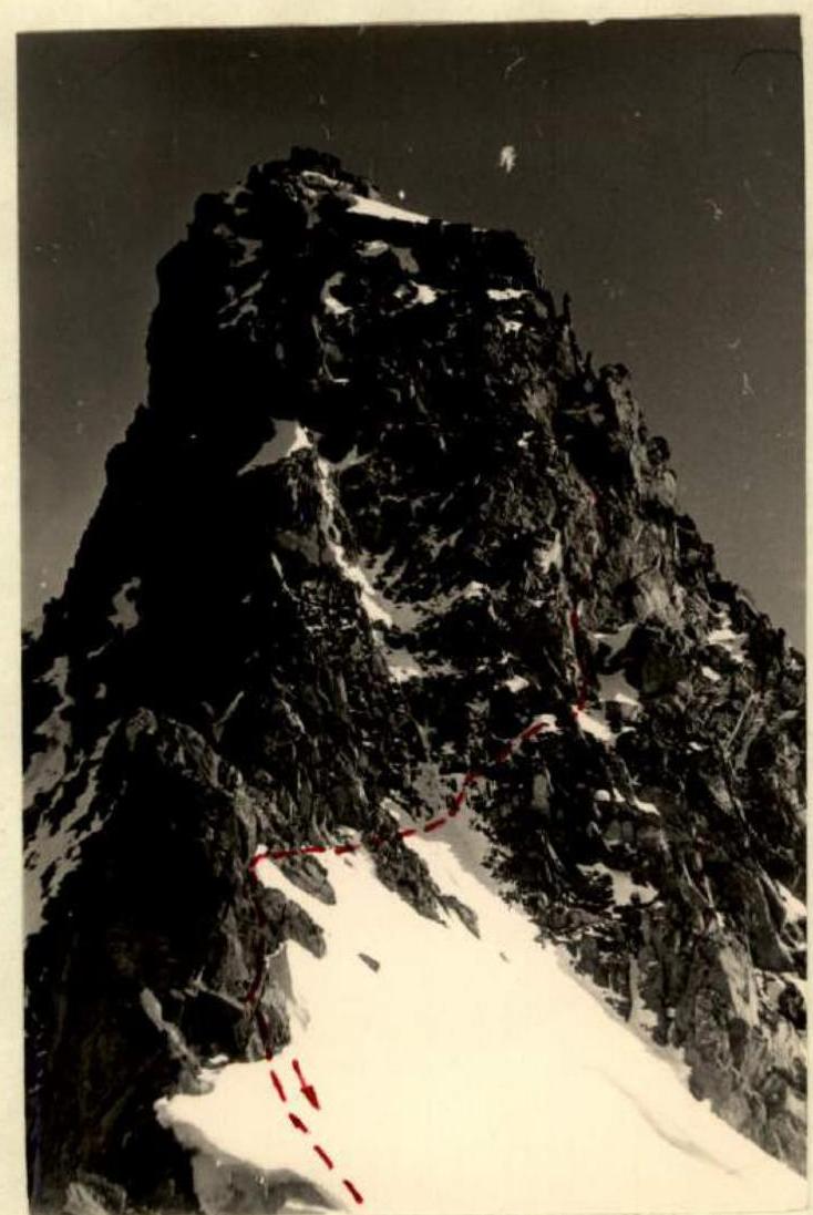
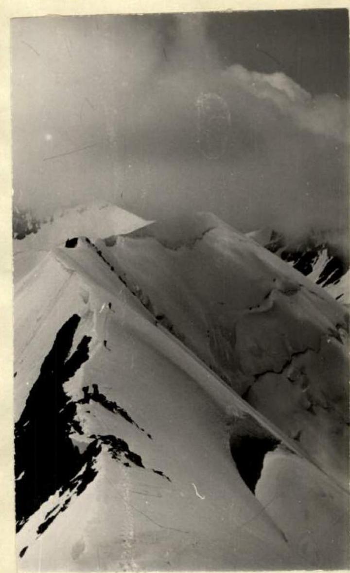 Ridge to the peak Jimaray — khokh.
The descent from the summit tower of Jimaray-khokh goes along the northern ridge. The first 500 m in height, the ice ridge with a steepness of 45° is traversed with hook belay. In the middle part of this section, on the first small "gendarme" from the summit, there is an intermediate cairn. This section is concluded by two "gendarme" formations; the first is bypassed from the left along very destroyed rocks, and on the second, we organize a bivouac. Organizing the bivouac took about 2 hours of hard work. The site was laid out from shale slabs on a slope with a steepness of 30°.
 Bypass of the first large "gendarme" on the northern ridge of Jimaray — khokh.
3rd day. July 31, 1965.
The "gendarme" on which the bivouac was organized is traversed directly when continuing the traverse. 40 m of descent from it lead to a simple ice ridge, the steepness of which does not exceed 35°.
The further path along the ridge is obstructed by two large "gendarme" formations, which are bypassed from the left along heavily destroyed complex rocks and ice with hook belay. Individual sections have a steepness of up to 60°.
Having overcome the "gendarme" formations, we ascend along an ice slope to the saddle of the ridge between the peaks Jimaray-khokh and Shau-khokh (Mininsky pass). To the left of the saddle, on the rocks, there is a cairn.
From here, we begin the ascent to the peak Shau-khokh along the southeastern ridge. The lower part of the ridge is rocky. The average steepness of the ridge is 45°. The rocks are of medium difficulty but are heavily destroyed, and great care is required when moving along them. In the middle part of the ridge, there are two sections of 60 m with a steepness of 55°, traversed with maximum caution; belay is possible only through accumulations of destroyed rocks; it is impossible to drive hooks. From the saddle to v. Shau-khokh is 700 m. In the middle part of the ridge, there is an intermediate cairn. The second section with a height difference of 300 m is snow-covered, simpler, and safer. The average steepness is 35°. The cairn on the summit of Shau-khokh is located 10 m below the highest point, on the rocks to the left.
On a slight bend in the ridge, the position of the cornices changes; they now hang to the north. In this place, there is a small depression in the ridge where we organize a bivouac. This is the only convenient spot from p. Geologov to v. Jimaray-khokh suitable for an overnight stay. The path from the base camp to the overnight stay takes 15 hours. The weather is getting worse; visibility is decreasing. While the others set up the bivouac, a duo, Kasparov-Slezin, goes on reconnaissance. They advanced about 200 m forward until they reached rocky sections. The reconnaissance was terminated due to a sharp deterioration in weather; visibility disappeared, and a hurricane-force wind swept across the ridge.
 Northern ridge of Jimaray. (view from the Shau-khokh ridge.)
From v. Shau-khokh, a long ridge stretches to the west, containing three peaks: Shau-khokh, Druzhba, and Zaygelan. We descend from v. Shau-khokh along the western ridge for 250 m along an ice slope with an average steepness of 40°. Here, we organize a bivouac, cutting out a platform in the ice in the gentlest spot at the junction of ice and rocks. This part of the traverse from the previous overnight stay takes 1 hour and 30 minutes.
4th day. August 1, 1965.
The further path from p. Druzhba is the most complex and dangerous section of the route.
From v. Shau-khokh to p. Druzhba, the route had not been previously traversed. It is characterized by the following features:
- Complex rocks, extremely destroyed
- Difficulty in organizing belay
- Increased danger of the route
Such a character of the rocks requires increased vigilance and special technique. This section of the route is traversed in continuous nervous tension.
This part of the route represents a highly jagged sharp ridge with a series of "gendarme" formations; the southern side of which drops with slabs, and the northern side is almost vertical ice walls, far descending onto the glacier.
From the overnight stay under v. Shau-khokh, we first move along a sharp ice ridge, which is traversed with step-cutting. Further, there is a descent from the first "gendarme" along very unstable rocks. The path goes to the left of the ridge with an average steepness of 45°. From the first "gendarme" to the second, the average steepness of the section does not exceed 40%, but the complexity does not decrease, as individual large boulders are traversed on top with assistance and alternate belay. A control cairn is set up on this section.
The descent from the second "gendarme" goes to the left along a crevice (complex climbing), leading to a small inclined ledge, from which a 20 m rappel down a sheer wall onto a sharp ridge follows, along which a 10 m traverse to the third "gendarme" is made, bypassing the "per" on the left. On this section, 6 hooks are driven. The height difference is 60 m; the average steepness is 70°.
The third "gendarme" is bypassed from the right; 40 m of traverse along very destroyed rocks with an average steepness of 70°. Here, it is possible to drive only one intermediate hook and two hooks at the beginning and end of the path.
After a horizontal bypass of the "gendarme," a 40 m rappel follows down a nearly vertical, very destroyed ridge, which by the character of the rocks resembles a brick wall not held together by cement. There is a danger of rocks and pendulum. The first person, descending, constantly cleans the route, throwing down tons of rocks.
(Except for these two rappel sections of 20 m and 40 m, the entire traverse is completed by free climbing).
The further descent path goes to the left along large blocks; complex climbing; it is impossible to drive hooks. The average steepness of this section is 60%; the height difference is 100 m. Further, an almost horizontal section of 80 m, sometimes with snow, leads to the fourth "gendarme," which is overcome directly along rocks of medium difficulty.
Beyond the fourth "gendarme," a horizontal ridge continues for 80–100 m in length with numerous "gendarme"-formations 3–6 m high, which are either bypassed on the left or overcome directly. Further, a large (60 m) fifth "gendarme" is overcome directly along steep rocks of medium difficulty but very destroyed. A cairn is left on the "gendarme."
The descent from the "gendarme" for 40 m leads to the sixth "gendarme"; the left part of which is a sheer destroyed wall, and the right part is accreted ice. The ascent is possible only along the ice, cutting out steps and holds. In the middle part, it is possible to drive one hook. The height of the "gendarme" is 30 m; the steepness is 55°.
The descent from the "gendarme" is very complex, along a sharp ridge composed of massive slabs with a smooth inclined surface. After 40 m of descent, we approach an eight-meter gap with sheer walls.
Then:
- A complex ridge with "per" formations and slabs leads to a depression before p. Druzhba.
- Here, a control cairn is left.
The ascent to p. Druzhba begins along a steep snow rib with a steepness of 50°; further, to the summit, we move along heavily destroyed rocky outcrops interspersed with snow sections. Having descended slightly from the summit and walked another 100 m along a horizontal wide ridge of small talus, we stop for a bivouac. The spot is excellent. This part of the traverse takes 12–13 hours. The further path from v. Druzhba towards v. Zaygelan does not present difficulties. After a gentle descent, we begin the ascent to v. Zaygelan, initially steeply upwards along a snow-ice slope with a steepness of 40°, and then along a very gentle wide ridge to the very summit. The northern side of the ridge is snow-ice; the southern side is rocky.
We descend from v. Zaygelan along the southern slope onto l. Midrograbin. In the upper part, we move along heavily destroyed slabs, and in the middle and lower parts of the slope, along talus. Having overcome the moraine ridges, we move along the Midrograbin glacier back to the base camp. The last section of the traverse took 6 hours.
The route as a whole is of a combined character, combining:
- Snow sections with cornices
- Ice slopes and ridges
- Complex rocky walls and ridges of a peculiar structure
The route is very interesting. Undoubtedly, in terms of complexity and length, it should be classified as 5B category of difficulty.
The overall assessment of the actions of the assault team during the ascent is excellent; all participants are physically and technically well-prepared; each can work independently on any type of relief and organize a bivouac in any conditions.
Observation Group
Simultaneously with the assault group, a group of разрядник (lower-category climbers) consisting of 8 people was present:
- 2nd category — 2 people
- 3rd category — 6 people
The senior of the group was E. Lipen.
The participants of this group completed ascents to the peaks Donchenty, Midrograbin, Suatissi-khokh, Tsiti-khokh, Khirkhaten, and Shau-khokh.
During the traverse, there was no joint movement with these groups; they also did not participate in supply drops for the assault group. The interaction of all groups was coordinated with the representative of the alpinism federation and the head of the CSP for the Tsey region.
Conclusion
The Midrograbin glacier area is of great value for conducting mountaineering events for athletes of the II–III categories. The under-construction automobile road to s. Jimara will allow delivering alpinists practically to the foot of the peaks. (Minor expenses will be required to restore the road section from s. Jimara to G RP-81).
Despite significant rockfall danger, methodically correctly conducted training sessions with разрядник on the unique rocky relief of the cirque peaks will help cultivate among alpinists:
- The need for very careful route passage
- Reliability of movement on rocks
- Clarity of work with a rope
The traversed route is valuable as it combines rocky and icy sections and requires alpinists to be versatile in their preparation.
Captain of the team V. Prazdnikov Coach of the team F. Narkevich.
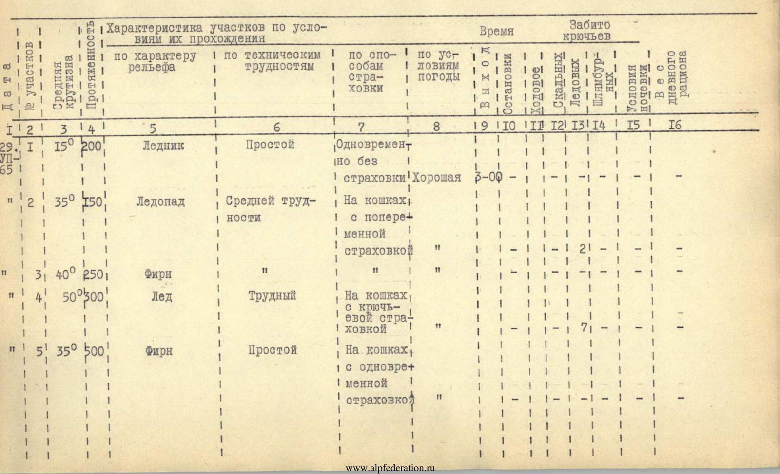
Route Table
| № участков | Дата | Средняя крутизна | Протяженность | Характеристика участков по условиям их прохождения | Время | Забито крючьев | Условия ночёвки | Вес дневного рациона |
|---|---|---|---|---|---|---|---|---|
| По характеру рельефа | По техническим трудностям | По способам страховки | По условиям погоды | |||||
| 1 | 29 июля 1965 г. | 15° | 200 м | Ледник | Простой | Одновременно без страховки | Хорошая | 3:00 |
| 2 | 35° | 150 м | Ледопад | Средней трудности | На кошках, с попеременной страховкой | — | — | |
| 3 | 40° | 250 м | Фирн | — | — | — | — | |
| 4 | 50° | 300 м | Лед | Трудный | На кошках, с крючьевой страховкой | — | — | |
| 5 | 35° | 500 м | Фирн | Простой | На кошках, с одновременной страховкой | — | — |
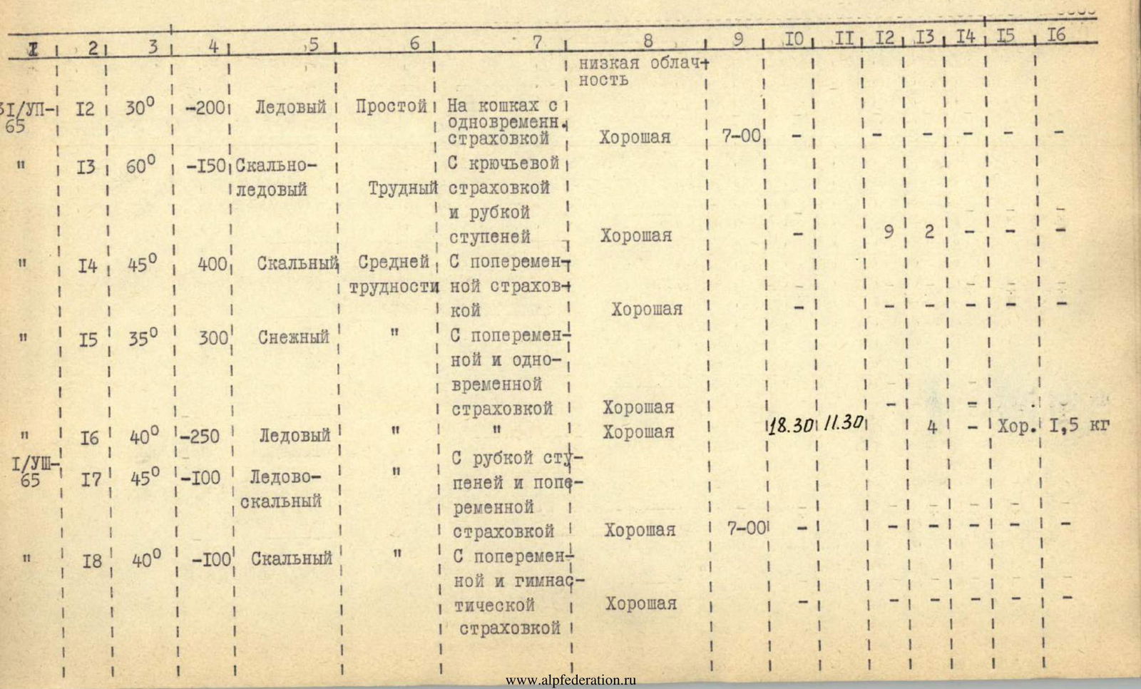
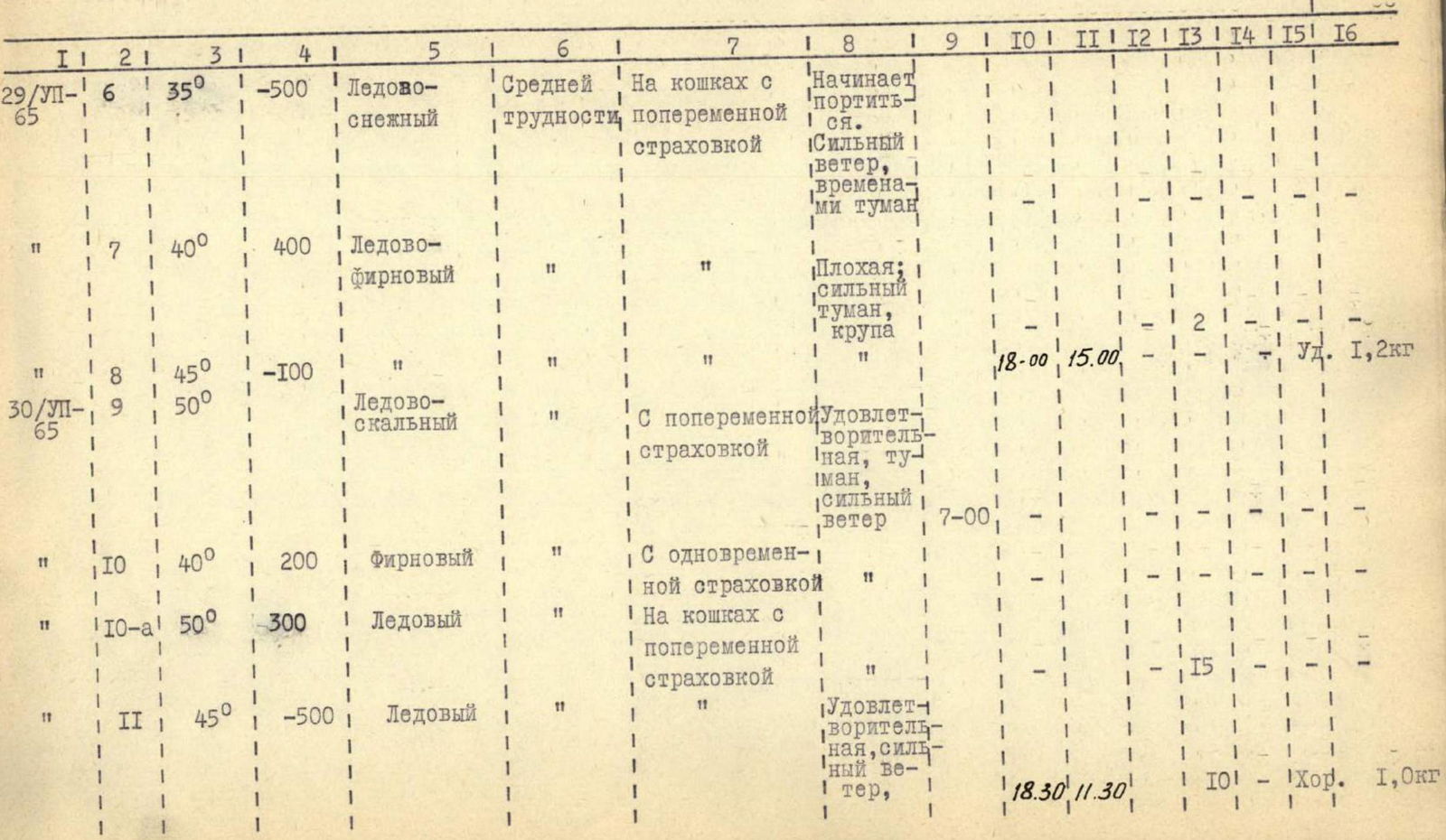
| № участков | Дата | Средняя крутизна | Протяженность | Характеристика участков по условиям их прохождения | Время | Забито крючьев | Условия ночёвки | Вес дневного рациона |
|---|---|---|---|---|---|---|---|---|
| По характеру рельефа | По техническим трудностям | По способам страховки | По условиям погоды | |||||
| 6 | 29 июля 1965 г. | 35° | 500 м | Ледово-снежный | Средней трудности | На кошках с попеременной страховкой | Начинает портиться. Сильный ветер, временами туман | — |
| 7 | 40° | 400 м | Ледово-фирновый | — | — | Плохая; сильный туман, крупа | — | |
| 8 | 45° | 100 м | Ледово-скальный | — | — | — | 18:00 | |
| 9 | 30 июля 1965 г. | 50° | — | — | — | С попеременной страховкой | Удовлетворительная, туман, сильный ветер | 7:00 |
| 10 | 40° | 200 м | Фирновый | — | С одновременной страховкой | — | — | |
| 10-а | 50° | 300 м | Ледовый | — | На кошках с попеременной страховкой | — | — | |
| 11 | 45° | 500 м | Ледовый | — | — | Удовлетворительная, сильный ветер | 18:30 |
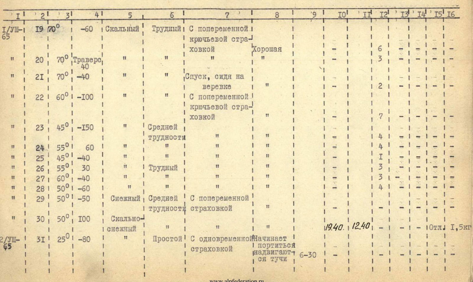
| № участков | Дата | Средняя крутизна | Протяженность | Характеристика участков по условиям их прохождения | Время | Забито крючьев | Условия ночёвки | Вес дневного рациона |
|---|---|---|---|---|---|---|---|---|
| По характеру рельефа | По техническим трудностям | По способам страховки | По условиям погоды | |||||
| 12 | 31 июля 1965 г. | 30° | 200 м | Ледовый | Простой | На кошках с одновременной страховкой | Хорошая | 7:00 |
| 13 | 60° | 150 м | Скально-ледовый | Трудный | С крючьевой страховкой и рубкой ступеней | Хорошая | — | |
Comments
Sign in to leave a comment