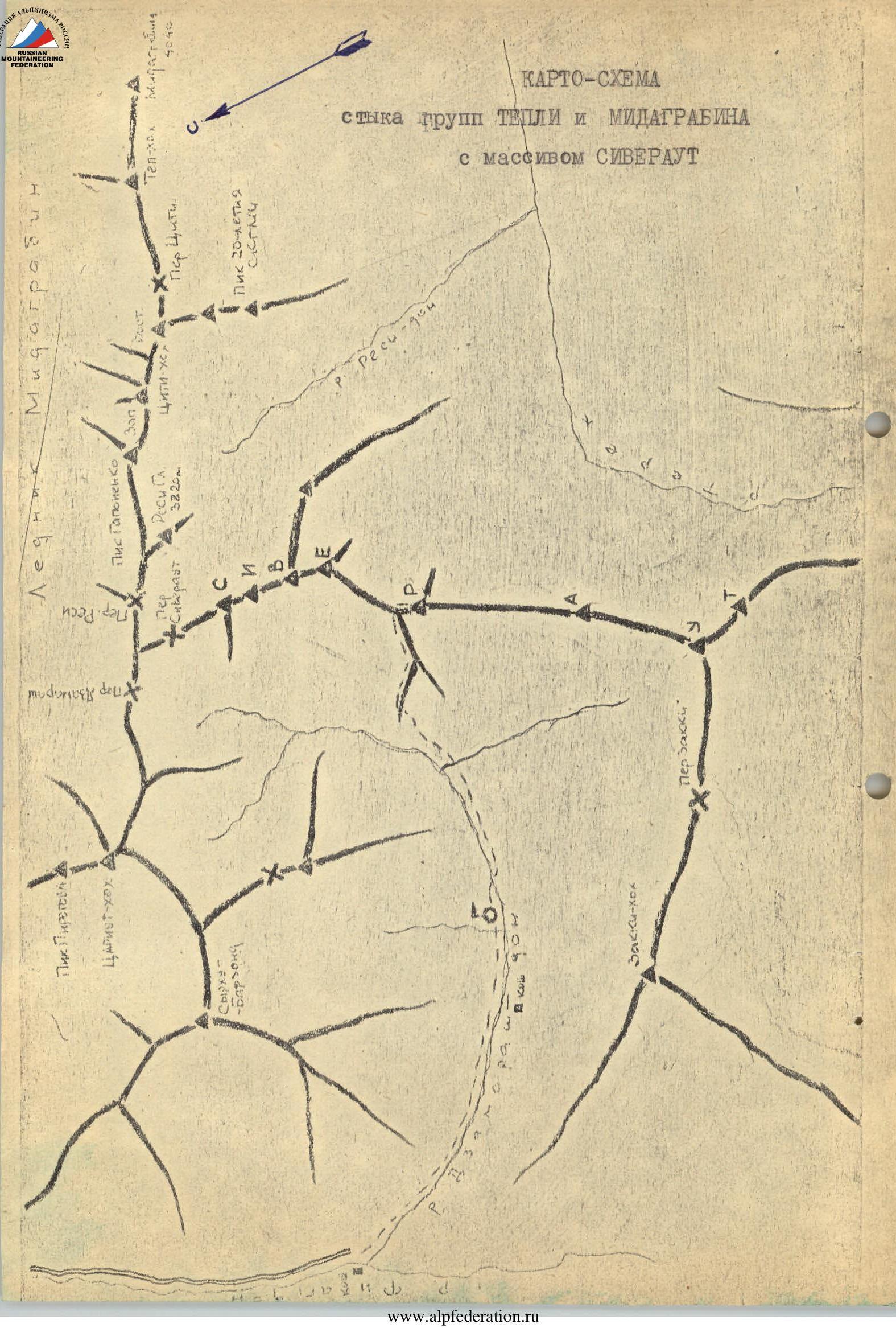
 Sketch-map of the junction of the Tepli and Midagrabin groups with the Siveraut massif
Route Description
Ascent to the 5th peak of Siveraut, Peak "R" (3785 m) via the northern ridge, category III difficulty
The Siveraut massif is an almost 10-kilometer wavy ridge stretching from northeast to southwest at the junction of the Midagrabin and Tepli groups of the Lateral Range of the Greater Caucasus. It has eight peaks, each assigned a letter index corresponding to the eight letters of the name (from Peak "S" in the northeast to Peak "T" at the southwestern end of the massif). The massif can be accessed by ascending to the upper reaches of:
- Zakkidon,
- Residon,
- Dzamarashdon, and Peak "S" can be climbed from the Midagrabin glacier.
There are possible passes in the ridge of the massif (approximately three).
The massif is composed of extremely fractured schist, with several small cirque glaciers. Some peaks of the massif have been conquered. For example, the first ascent to Peak "S" was made in the 1930s. The first ascent to Peak "R", the 5th peak of Siveraut, was made from the Dzamarashdon valley on May 3, 1968, by a group of climbers from the SKF SKB "Tsvetmetavtomatika" from Ordzhonikidze, led by R.P. Proskuryakov.
Day 1. The drive from Ordzhonikidze to the upper reaches of the Kurtatinsky gorge to the confluence of the Fiagdon and Dzamarashdon rivers takes about 2.5 hours. The route passes through the villages of:
- Dzuarikau
- Lats
- Khadikus
- Kharischin
From the last village, it is 13 km to the confluence of the rivers, where a shepherd's camp is located. From there, it is advisable to approach the massif on the same day via the Dzamarashkom valley. About an hour's walk from the camp, there is a suitable bivouac meadow.
Day 2. Early departure. Move up the occasionally disappearing trail winding along the left (orographic) bank. After an hour, the trail leads to the foot of the Siveraut massif, which blocks the valley. The group faces a 300-meter ascent, followed by a wide grassy and scree terrace.
The steep ascent:
- In summer, is bypassed to the right via a trail in the canyon;
- In winter, it is safer to ascend directly up the steep grassy slopes and groups of broken rocks (caution is required!).
From above, a scree slope descends to the wide terrace, with individual outcrops of bedrock schist. The spur is quite steep and changes direction in its upper third, rising southeast to meet the main ridge of the Siveraut massif.
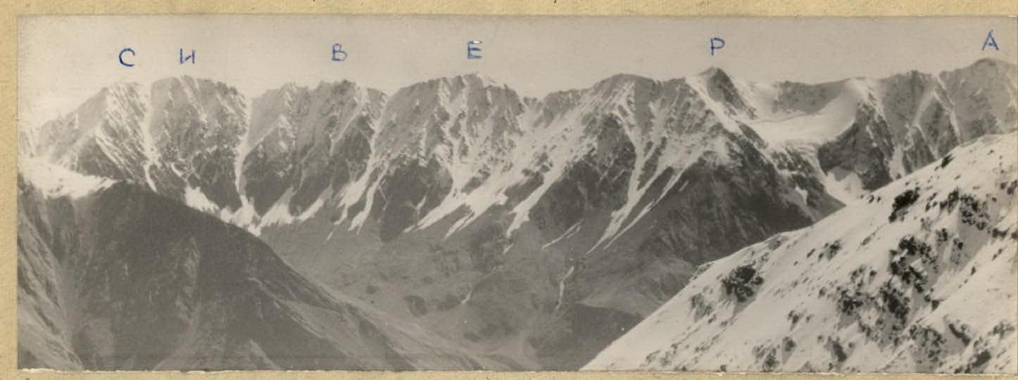
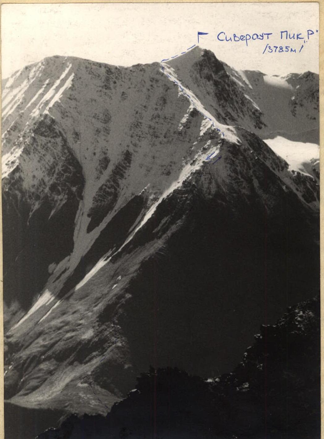 Siveraut. Peak "R". View from the north. Telephoto by R. Proskuryakov
The ridge route deviates from the ridge line only after the first 400-meter ascent above the wide terrace, where outcrops of more solid rocks form two "gendarmerie". By passing the first "gendarme" to the right via snow in rope teams, climbers enter a narrow couloir separating the "gendarmerie" and ascend it for about 20 meters. Then, they move to the right via simple rocks, crossing the edge of the second "gendarme". Further up, there is a straightforward ascent via broken rocks and scree to the ridge line beyond the second "gendarme". Protection on this section is via rock outcrops, and on snow, via an ice axe. Beyond the "gendarmerie", the ridge widens and becomes gentler. Movement is simultaneous.
After about 250 meters, the steepness of the ridge increases, with sections of fractured schist rocks that:
- can be bypassed to the right;
- or overcome directly with simultaneous protection.
To the left, steeper scree and snow slopes descend, making right-hand bypasses along the entire ridge natural.
Further up, the entire route follows the ridge line. Sections of fractured schist rocks alternate with snow and scree sections.
The steepness of the ridge varies from 35 to 50°. The spur leads to the junction with the main ridge of the Siveraut massif. The passage along the ridge takes approximately 5 hours.
In the upper part of the ridge, on the rocks of the most prominent ascent, a control cairn is located on the route, from which it takes about an hour to reach the summit.
From the junction of the ridges, a 150-meter snow and ice ascent leads to the dome-shaped summit of Peak "R". To the north, large snow cornices overhang the ridge (caution is required!). Movement is in rope teams. The summit plateau is quite large, with a cairn located at the highest point.
The descent is made via the ascent route and takes about 3-3.5 hours to the valley. Another 5-6 hours will bring you back to the bivouac, from which it is a 0.5-hour descent to the road. By car, it is possible to drive to Ordzhonikidze via the Kurtatinsky gorge and the Alagir highway in 1.5 hours.
Equipment recommended for a group of 4:
- 30 m ropes – 2
- Belay devices – 2
- Rock pitons with long blades – 5
- Ice pitons – 2
Description compiled by R. Proskuryakov