- Pik Polyakova Yuriya (4271 m) via the central North-West buttress, cat. III.
- Leader: Egorin S. V.
- Caucasus. Bokovoy Range. Kazbek-Djimara massif.
- Section number in KTMGV 2.8.
Route Description
Ascent Data Sheet
- Caucasus. Bokovoy Range. Kazbek-Djimara massif. Section number in Classification 2.8.
- Pik Polyakova Yuriya 4271 m (in the 2001 Classifier, item 2.8.81—peak 4005 m), via the central North-West buttress.
- Category 2A is proposed, first ascent.
- The nature of the route is combined.
- The height difference of the route is 1400 m (by GPS). The total length of the route is about 2500 m. The length of sections with category 3 difficulty is about 100 m. The steepness of key sections is up to 60°. The average steepness of the route is 30°.
- No pitons were left on the route.
- Climbing hours: 12; days: 2.
- Leader: Egorin S. V. — Master of Sports.
Participants:
- Volkov V. N. — Candidate for Master of Sports
- Vasyukov V. V. — badge holder
- Coach: Egorin S. V. — Master of Sports.
- Departure to the route: July 17, 2008. Summit: July 18, 2008. Descent: July 19, 2008.
- Organisation: North Ossetian Search and Rescue Team, EMERCOM of Russia, North Ossetian Alpine Federation.
- Leader's contact information for report inquiries:
phone: 89188267912; email: es128@mail.ru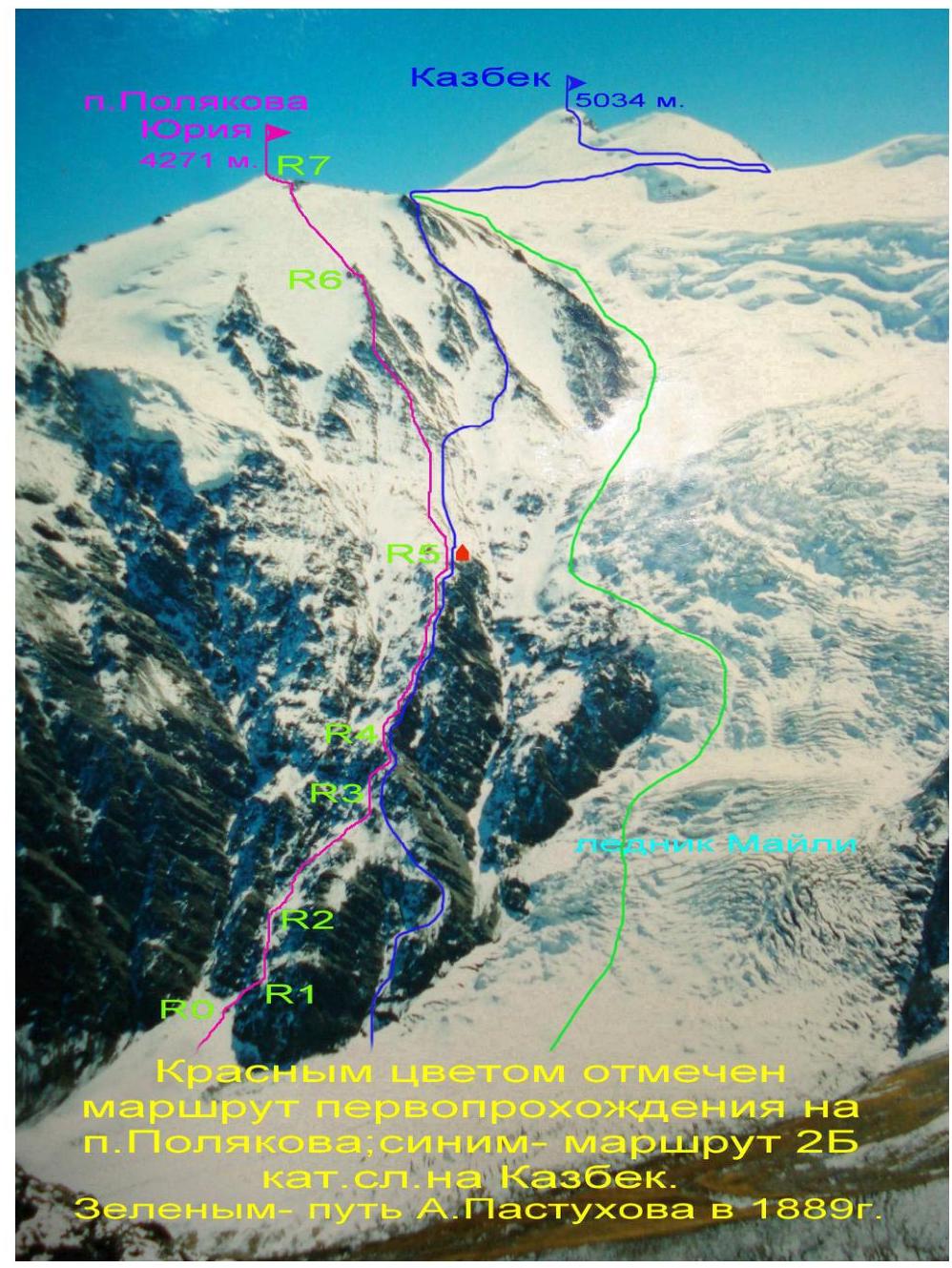
Kazbek-Djimara Massif. Brief Overview of the Area
One of the largest glacial massifs of the Bokovoy Range, the Kazbek-Djimara massif, occupies the extreme south-eastern part of North Ossetia. This powerful and complexly structured mountain uplift is bounded to the west by the Fiagdon river gorge and to the east by the Darial gorge of the Terek river. It stretches 60 km in length and 35 km in width, with an average height of 4000 m. Over ten peaks in this massif exceed 4000 m above sea level.
In the center of the Kazbek-Djimara massif rises the peak of Djimaraikhokh (4780 m), and slightly to the east, on the border with Georgia, lies Kazbek (5034 m).
To the north-west of Kazbek lies a large snow-firn plateau known as the Kazbek Plateau. In its northern part is located the peak 4271 m, previously known among tourists as Pik OZhD. In the 2001 Classifier, there was only one route listed to this peak under number 2.8.81, and even then, the height of the peak was incorrectly indicated as 4005 m. A route of category 2A was ascended to this peak via the North-East ridge in 1965. The Classification Commission of North Ossetia sent a clarification to the Alpine Federation of Russia regarding the name and height of the peak. Now, according to Supplement No. 1–6, this peak is named Pik Polyakova Yuriya (4271 m) in honor of the alpinist from North Ossetia, Master of Sports of the USSR in alpinism, Polyakov Yuri Vasilievich.
To the north-east from Pik Polyakova Yuriya, a long ridge of category 2A difficulty leads to the peak of Chachkhokh (4068 m). To the south of the peak lies the Kazbek Plateau. The eastern slopes of the peak descend into Georgia, into the Amaldon river gorge.
To the west-north-west from Pik Polyakova Yuriya, a glacier descends, which lower down turns into scree slopes with buttresses. This slope descends onto Russian territory, into the Genaldon river gorge, towards the upper Karmadon thermal springs.
The first ascent of this slope from the Karmadon gorge side to the summit of Kazbek was accomplished in 1889 by A. Pastukhov. Judging by the description of his ascent, he passed through a snow-ice slope where the Maili icefall is currently located. Although it is now believed that he traversed the buttresses of the North-West slope—though nowhere in the description of his ascent is it mentioned that he moved across rocks.
At that time—120 years ago—the amount of snow and ice in the Kazbek-Djimara region was much greater than it is now. And there were an order of magnitude fewer crevasses on the icefall. In confirmation that Pastukhov bypassed all the buttresses to the right via the snow-ice slope, one can refer to the history of conquering Kazbek from the Karmadon gorge side: "Kazbek". A. Titov. FiS. Moscow, 1938.
http://piligrim-andy.narod.ru/text/kazb38.html↗
Ascent of A. V. Pastukhov
In 1888, a resident of Vladikavkaz, an Ossetian by nationality, Tulalov, for the first time laid a path to Kazbek from the Genaldon (Maili) glacier side. In the Ossetian village of Tmenikau, located in the upper reaches of the Genaldon river, he found a brave companion, a local tour hunter, also an Ossetian—Tsarakhov. Tulalov took a red flag with him, which he wanted to plant on the summit and thus prove to the population the fact of his ascent. But a snowstorm and rain prevented Tulalov and Tsarakhov. Neither on July 14, 1953, nor on August 8 did they manage to reach the summit, and the flag had to be left on the approaches to it. But Tulalov's idea was picked up and implemented the following year by the topographer and alpinist Pastukhov.
Pastukhov conducted topographic surveys in the Genaldon valley in the summer of 1889 and wanted to fulfill his long-standing desire to visit the summit of Kazbek.
Despite being only 28 years old, Pastukhov was already a sufficiently experienced alpinist. Since the age of 20, he had worked in the Caucasian Military Topographic Department and spent the last two years working in the upper reaches of the Argun, where he had to climb into the most elevated parts of the Andi Range.
Despite this, the ascent on Kazbek was a serious test for Pastukhov and the first step towards future victories on Elbrus and Ararat.
Upon arriving in Tmenikau, Pastukhov prudently found Tsarakhov and persuaded him to go to the summit again. In addition, he took two Cossacks—Lapkan and Potapov—from his unit.
After spending the night on July 27 near the hot springs, 30 meters from the Maili glacier, they began their ascent at 3 pm. They walked on the glacier with steel crampons on their feet and armed with poles with steel tips. Pastukhov led the way, clearing the path. In his hands, he carried a long pole-shaft, and among the few things in his travel bag were 3 arshins of red calico for a future flag on the summit. Passing through a place where the glacier was covered with snow from a recent landslide:
- Pastukhov slipped and fell into a crevasse masked by snow;
- He was saved from certain death by the pole, which he carried in a horizontal position and did not release from his hands, hanging over the terrible bluish abyss.
The further path was also fraught with glacial crevasses, which they managed to circumvent.
They spent the first cold night under the shelter of a rock. In the morning, Potapov began to suffer from altitude sickness. They had to leave him 200 meters from the night's halt with a significant supply of provisions.
At noon, they began to approach a giant firn basin, occupying at least 6 square kilometers. The altimeter showed 13,664 feet. On that day on the firn, the pole once again saved Pastukhov from death at the bottom of an icy abyss. They had to proceed even more slowly and cautiously. Mountain sickness tormented them more and more, and terrible thirst joined it. At the end of the day, they found a small area strewn with shale debris for their second night's halt. The second night was colder than the previous one, and it was hard to fall asleep.
The fog that enveloped the summit of Kazbek and crept up the firn field soon dispersed. "Above us was a blue, almost black sky studded with stars," Pastukhov recalls. "From behind Kazbek's summit, the moon slowly rose, bathing the silver surface of the snows in its light. Sometimes, amidst this silence, a terrible crack of ice resounded, and, repeated by a hundred-voiced echo, quietly died away somewhere in a distant gorge."
On the morning of July 29, they continued their ascent. They set out in a trio but new severe attacks of mountain sickness hindered Lapkin's progress. His eyes darkened, his legs became alien, and they had to let him go, continuing on in a duo.
Due to dense morning fog, they headed south and approached the base of the western summit. Realizing their mistake, they turned southeast; upon reaching the junction of the two summits, they turned east and began to ascend towards the pass between Kazbek's summits.
The slope was difficult and steep, requiring:
- cutting steps.
Soon, Tsarakhov too was exhausted. He increasingly called for a return, stopped, left Pastukhov, and began to descend, but seeing with what persistence the latter continued to move forward in silence, he followed him again.
At 12:30, they reached the middle of the ridge leading from the western summit to the pass and made a halt. All around was snowy and quiet. White peaks stood calmly, and the sky was blue. And suddenly, three butterflies of a reddish color flew by one after another, easily carried by the wind in a southerly direction. For two days, this was their first encounter with living creatures.
Upon descending from the pass, they found the flag left here the previous year by Tulalov.
At half past one, Pastukhov and Tsarakhov approached the base of the eastern summit and, cutting steps into the almost sheer wall, began their final ascent. At 16:00, they reached the summit. Pastukhov could not subsequently convey the stunning view that unfolded from there on that clear evening when the setting sun bathed the endless chains of snowy ridges and peaks. Having made the necessary observations and measurements of the summit, Pastukhov and Tsarakhov began to secure a red three-meter-long banner on a high pole.
Thus, the belief in Kazbek's inaccessibility among the local population was finally dispelled only after the sixth ascent of this peak.
Pastukhov was not entirely lucky. Before the detachment's descent into Tmenikau, a downpour of Kekti, an unusually strong shower swept over the gorge. Streams of water washed away the ripening crops of oats and barley, flooded homes, and washed away roads. The darkest part of the population interpreted the downpour in their own way: "The Russians 'bewitched' the Ossetian, they together desecrated the summit with their feet, and no one could stop them. Now God has avenged Tmenikau for the committed sin." But despite the direct incitement of the crowd against Pastukhov, respect for his courage and bravery prevailed, and he safely left the village.
To confirm that the North-West slope was passable at that time, one can refer to the second passage of this route by G. Merzbacher.
Ascent of G. Merzbacher. Two years later, in 1891, a member of the Austro-German Alpine Club, the future professor and well-known researcher of the Caucasus and Pamir, G. Merzbacher, traveled through the Caucasus. He ascended Kazbek via the path of Tulalov and Pastukhov but more successfully than they did. The path to the summit, which took Pastukhov 3 difficult days, Merzbacher easily overcame in 1 day. But this success, according to Merzbacher himself, was explained solely by the exceptionally favorable state of the snow, equally dense along the entire path.
By the mid-1920s, when the retreat and melting of glaciers became significant, the passage to the right of the right buttress became very complicated due to a significant increase in the number of crevasses on the icefall. Climbers on Kazbek from the north-west had to seek a path through the lower part of the central buttress, located to the left of Pastukhov's route. They began to exit onto the lower part of the central buttress on its right side. That is:
- First, along the lower part of the central buttress,
- Then—a diversion to the right onto the upper part of the right buttress.
Currently, the path to Kazbek, category 2B difficulty, from Russia's side (from the Karmadon gorge) is exactly like this. Over time, this path began to be mistakenly considered as Pastukhov's route, although from the above description of his ascent, it becomes clear that he nowhere went across rocks but moved along the slope where the Maili icefall is now located.
All these North-West buttresses are, in essence, buttresses of the peak 4271 m, i.e., Pik Polyakova Yuriya. The upper part of the central buttress had not been previously ascended. In July 2008, a group led by Egorin S. V. accomplished the first ascent of the upper part of the central North-West buttress, exiting onto the central buttress in its lower left part.
Approach to the Route
The climbing area is a border zone, and to visit it, one must first obtain a permit at the border outpost in the suburb of Vladikavkaz, in the village of Verkhny Redant.
After the collapse of the Kolka glacier in 2002, there is no passage through the Genaldon river gorge from below. To reach the Karmadon gorge, one must travel via the Kurtat gorge and, before reaching the village of Verkhny Fiagdon, turn left towards the Kakadur pass leading into the Dargavskoye gorge. Along a dirt road, descend into the Dargavskoye gorge and further drive to the Zeleny pass (1791 m).
Then, from the pass, head south along the old dirt road. After 300 meters, one must descend to the left down to the Komidon river and, after crossing it, exit onto the old road that goes left towards the village of Tmenikau. Within 1.5 hours from the Zeleny pass, one can reach above Tmenikau on the road leading up the Genaldon (Karmadon) gorge. The distance from Vladikavkaz is about 70 km.
It is possible to approach this same location from below through the Karmadon sanatorium. To do this, one must descend from the Zeleny pass along the motor road to the Karmadon sanatorium, losing about 300 meters of elevation, and then head up towards Tmenikau.
One can also reach the Karmadon sanatorium by high-clearance vehicles from the east. To do this, one must first travel along the Military Georgian road, then turn west after the village of Chmi, and descend through the Saniban pass to the village of Gornaya Saniba in the Karmadon gorge. After crossing the Genaldon river by bridge, one can also reach the Karmadon sanatorium. The distance from Vladikavkaz is about 40 km.
Above the village of Tmenikau, there is a border post. Further, one must proceed up the gorge along the old road. The path to the upper Karmadon hot springs is now clearly visible. It initially follows the old road, then descends into the Genaldon river floodplain, and continues along the right bank of the river. In places, the road has been washed away by the Kolka glacier that descended on September 20, 2002, and the path follows a trail. In the floodplain, one must follow the river along a trail that is visible in places, orienting oneself by cairns. Within 4–5 hours of walking from Tmenikau, the trail begins to ascend to the right upwards and leads to areas near the upper Karmadon hot springs—2280 m according to GPS.
Near the hot springs, there is typically a night's halt. After passing the springs, one must:
- descend to the river;
- cross the Genaldon river on a bridge made of planks (in summer, the planks are often flooded with water and can be slippery, necessitating insurance!);
- After crossing the river, move up the slope to the left, towards the left edge of the visible Kolka glacier.
One approaches the glacier along the river via a grassy-scree slope. Before the steep part of the glacier, one turns left around the corner, along a gentle slope of the glacier covered with scree.
Further, one must proceed along the lateral moraine of the glacier along its left part. In places, there is a trail and cairns. The direction of movement is towards the base of the visible North-West buttresses of Pik Polyakova.
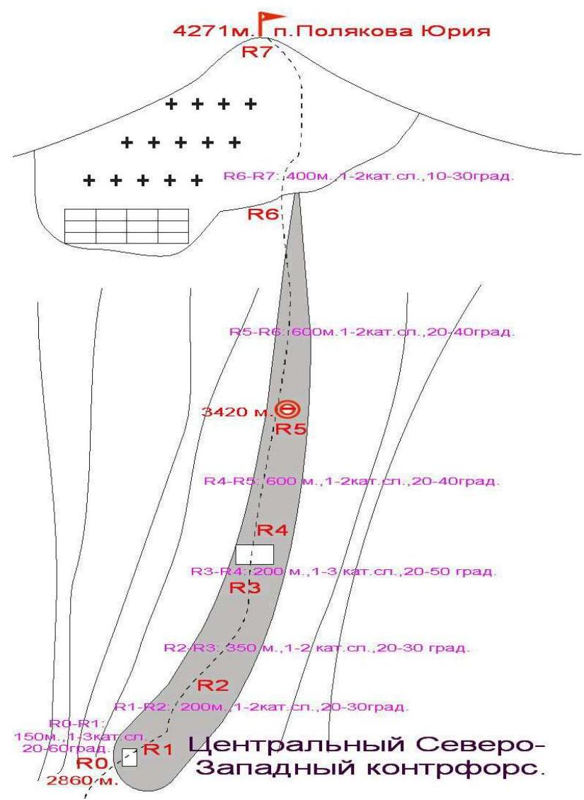
After the moraine ends, one proceeds along the avalanche cone of the couloir located under the hanging glacier descending from Pik Polyakova. Attention! Avalanches and rockfall are possible in the couloir! One must proceed along the lower, gentler part of the cone. Having crossed the base of the couloir, one begins to ascend upwards towards the waterfall, under the base of the left part of the central North-West buttress. To the right and just before the waterfall, 100 meters away—is the start of the route. The height here is 2860 m.
GPS coordinates of the route start in WGS-84 format:
| Height | N (North Latitude) | E (East Longitude) |
|---|---|---|
| 2860 m | 42°44′10.2″ | 044°28′44.6″ |
Route Description
Section R0–R1: Turning right, we proceed along a narrow scree ridge under the start of the rocky section. Along ledges with small walls of category 2–3 difficulty up to 60°, we move right upwards to a large scree terrace. The section is about 150 m.
Section R1–R2: On the scree terrace, we turn left and continue along the left part of the buttress, bypassing all difficult sections along ledges. We pass the narrow rocky part via a scree couloir (stones!). The entire section is about 200 m, category 1–2 difficulty, 20–30°.
Section R2–R3: Along snow-scree fields, bypassing rocky outcrops along ledges, we move right upwards to exit onto the ridge of the central North-West buttress. The section is about 350 m, category 1–2 difficulty, 20–30°.
Section R3–R4: Along the line of the buttress ridge or its left part, we approach under the rocky ascent of the buttress. Through rocks of category 2–3 difficulty, we exit onto scree ledges above the ascent. The entire section is about 200 m, category 1–3 difficulty, 20–50°.
Section R4–R5: Further up the North-West buttress, bypassing difficult sections to the left along scree terraces with individual rocky outcrops. After 600 m, we exit onto a flattening of the central North-West buttress. Here is a suitable place for a night's halt. From the start of the route, it takes about 7 hours. GPS coordinates for the night's halt in WGS-84 format:
| Height | N (North Latitude) | E (East Longitude) |
|---|---|---|
| 3420 m | 42°43′47.1″ | 044°28′55.9″ |
Section R5–R6: From the night's halt, we ascend along the buttress upwards. In the lower part, it is wide and scree-covered, but after about 300 meters, it narrows, and rocky outcrops appear. Difficult ascents of the buttress are predominantly bypassed to the left along rocks of category 1–2 difficulty, 20–40°. After another 300 meters, snow appears, and the buttress ends.
Section R6–R7: Further, we move upwards along a snow-ice slope of category 1–2 difficulty, 20–30°. Crampons are necessary! Insurance via an ice axe or, with little snow, via ice screws. We must head towards the visible summit ridge, from one small rocky outcrop to another—here the slope is most convex. After 300 meters, we exit onto the south-western summit ridge of Pik Polyakova Yuriya. Turning left and proceeding along a simple snow-scree slope for 100 meters, we reach the summit cairn.
The summit is a good panoramic point. Visible are:
- to the east—the peaks of the Kistinka gorge,
- to the north—Chachkhokh,
- to the south—Kazbek and Maili,
- to the west—Djimara and Shaukhokh. From the night's halt at 3420 m to the summit takes about 5 hours.
Descent is via the ascent route or along the upper part of the right North-West buttress to the night's halt. For the second option:
- Descend from the summit along the south-western ridge to its steep bend towards the Maili icefall.
- Bypass the rocky bend to the left along the route.
- Descend via rappels to the right downwards, exiting onto the line of the ridge of the right North-West buttress.
- Further, proceed along it downwards and, not reaching the night's halt by about 400 meters, turn right, crossing a snowy couloir, onto the central buttress.
 The route of the first ascent to Pik Polyakova is marked in red; the category 2B route to Kazbek is in blue. The path of A. Pastukhov in 1889 is in green.
Conclusions and Recommendations for the Route
The route is recommended for training ascents by sports groups and for educational ascents.
The route is combined, and it is necessary to have crampons for its passage.
When traversing the route, one must follow the description precisely to avoid encountering difficult sections. When passing the rocky part of the buttress, insurance is provided via outcrops.
In winter and during the off-season, with a significant amount of snow, beware of avalanches, especially in the upper part of the buttress.