Climbing Passport
-
Climbing category: technical
-
Climbing area: Caucasus: 2,86 Genaldon river gorge
-
Peak, route: p. 4312: via N. ridge from the Maili glacier (named after Tsarakhov T.)
-
Estimated category of difficulty: 3B — first ascent
-
Route characteristics:
height difference — 1800 m, route length — 2400 m, length of sections — 4th category of difficulty — 40 m, 3rd category of difficulty — 600 m, average steepness of the main part of the route — 45°
-
Pitons used: rock — none
ice screws — 16
-
Number of climbing hours (days) — 30 (3)
-
Number of nights: 1st — on approach
2nd — on the route 3rd — on descent
-
Team leader — Gorbunov Andrey Ivanovich, 2nd sports category.
Team members: Bondarenko S.O. — 2nd sports category, Korenkov V.A. — 2nd sports category.
-
Coach: Gudenko Vladimir Pavlovich — Candidate Master of Sports
-
Departure to the route: August 15, 1994.
Return — August 18, 1994.
-
Organization: FST RSO-A 362031, RSO-A, Vladikavkaz, 3 Kotsova st. 373.
Brief Overview of the Climbing Area
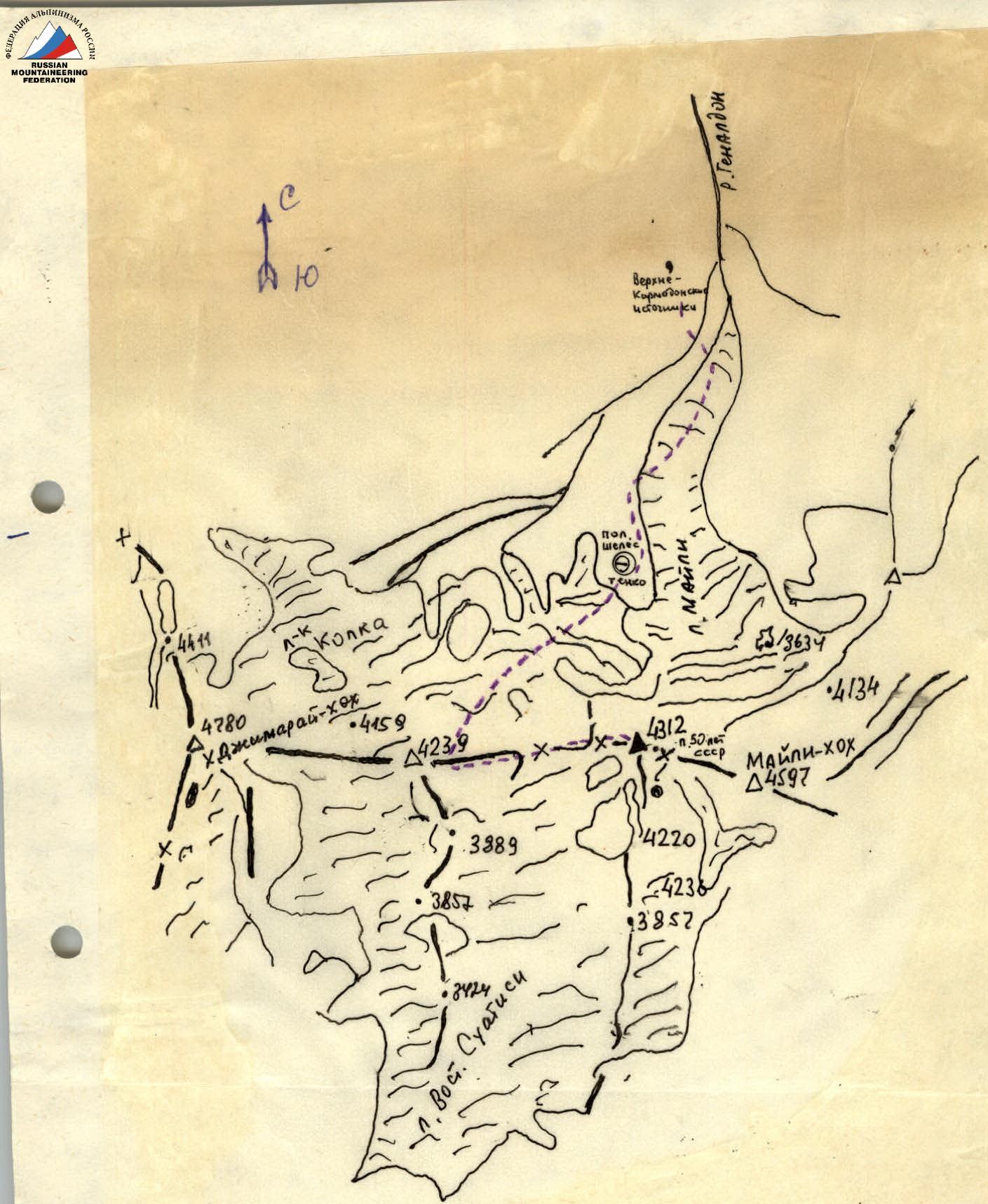
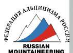
Peak 4312 is located in the territory of the Republic of North Ossetia-Alania on its southern border with the Republic of Georgia between the peaks Maili-khokh (4601) and the eastern counterfort of the peak Jimaraikhokh (4773), closer to the first. From the north, the ridge of peak 4312 closes the right part of the upper plateau of the Maili glacier (together with the 50 Years of USSR pass — 2B category of difficulty), and from the south, it closes the spur of the East Suatisi glacier.
There are two peaks in the ridge — 4210 and 4312. A route of 3B category of difficulty was laid to peak 4210 in 1993 by R.P. Proskuryakov, but the corresponding report was not prepared and the route was not classified.
The massif is composed of schist rocks in the lower part and has significant glaciation in the central and upper parts. To the right, the ridge of peak 4312 drops off with steep (up to 55°) ice slopes onto the East Suatisi glacier, and with its left part — a 35–40° ice slope to the 50 Years of USSR pass.
From the north, the ridge of peak 4312 drops off with steep ice (in the upper part — rock) slopes onto the icefall of the Maili glacier, and from the south — with gentle talus slopes onto the East Suatisi glacier.
The goal of the first ascent was to climb the neighboring, isolated peak and name it peak Tsarakhov in honor of Tepsariko Tsarakhov, who first ascended Kazbek in the middle of the last century as a guide with military topographer and alpinist A. Pastukhov. In addition, T. Tsarakhov discovered the unique Upper Karmadon hot springs.
Preparation for the Ascent
During preparation for the ascent, photographs of the massif were taken from the peak OZhD and peak Geodesist. Reconnaissance of the approaches was conducted, the orientation of the route, its preliminary assessment, and principles of radio communication were determined. It is best to establish communication with:
- Koh tis ar tourist base
- City of Vladikavkaz.
Description of the Approach
From the city of Vladikavkaz to the "Karmadon" sanatorium by regular bus — 1 hour. Further movement along the road through the lower baths, through the koshe above the Genaldon river. After 2 hours, the road ends and a trail begins, lost among the stones. Along the trail straight up with a gain in height along the left (orographic) bank of the Genaldon river to the Upper Karmadon hot springs. From the village of Karmadon — 3.5–4 hours. Height — 2400 m above sea level. Convenient bivouac.
Route Description
From the Upper Karmadon hot springs, descend along the moraine deposits traverse to the Genaldon river, cross it near the beginning of the large moraine (in summer, the river is turbulent, a suspended traverse is possible), descending from the central part of the Maili glacier. Further:
- Ascend the moraine and exit onto the glacier.
- Ascend onto the glacier and, moving towards the visible icefall of the Maili glacier, exit into its middle part.
- 200–250 m before the beginning of the icefall, turn right and ascend a low, steep moraine to the Shelestenko clearing.
From the hot springs — 2–3 hours. Here is the initial bivouac.
From the Shelestenko clearing straight along a small stream 200–250 m, turn right and ascend a gentle, high moraine to its crest. From here straight along the crest, orienting towards a large rock counterfort, approach its beginning. Turn left and traverse a wide talus couloir (serac falls, avalanches!). Ascend steep, broken rocks (belay!) to the talus slopes and, moving straight up for 200–250 m traverse, go to its left part. Overcoming steep talus slopes with rock outcrops, ascend to a small platform with a cairn. From here:
- ascend a 10-meter rock wall (belay!) upwards;
- exit onto the crest of the counterfort via a steep talus slope.
Here is a convenient bivouac. From the Shelestenko clearing — 3–3.5 hours. Height 3000 m.
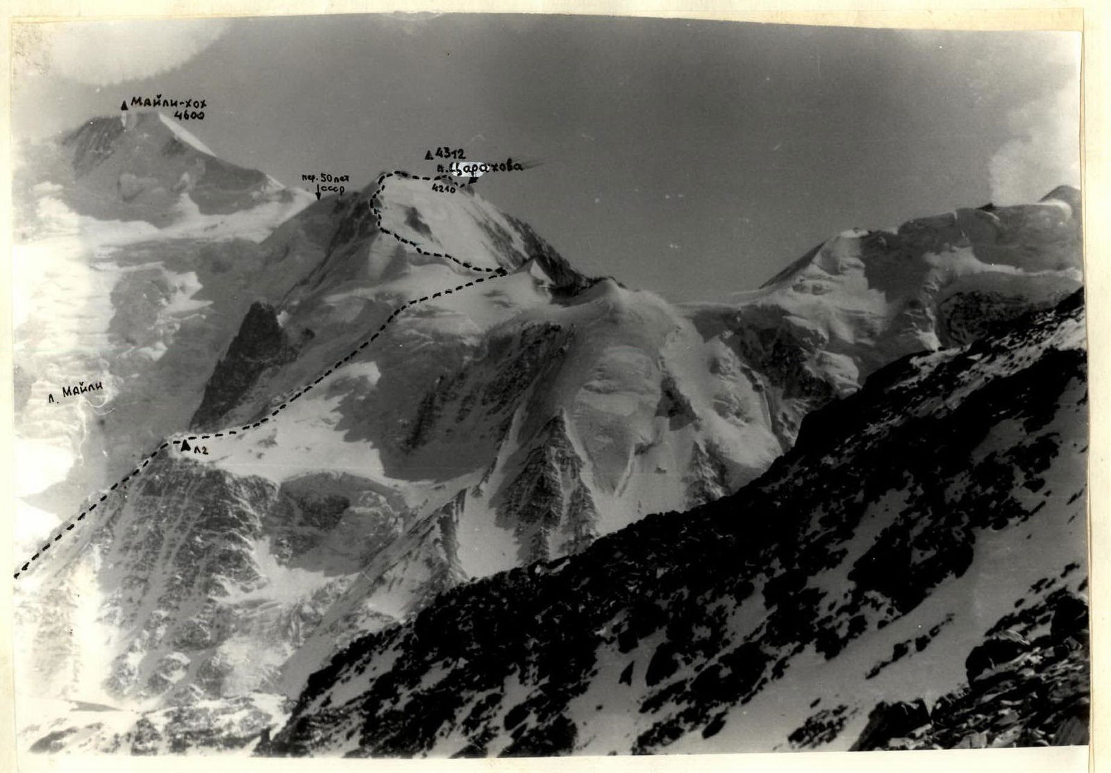
From the counterfort straight along the moraine ridges, approach the beginning of a steep 600–700 m ice slope. Along the slope (35–40°), adhering to its right edge along the icefall, ascend to a longitudinal crevasse 300 m. From here along a 40–45° ice slope (pitons for protection), ascend another 300–400 m upwards and exit into a gentle snow cirque to the left of a rock outcrop. Overcoming the bergschrund along a 30–40 m ice slope (protection), exit onto the rock ridge.
From the ridge, turn left and along simple, broken rocks, approach the beginning of a 100–150 m steep 50° ice ascent. Overcoming the ascent (pitons for protection), exit onto an inclined plateau and along it approach the beginning of the rock ridge.
Ascend simple rocks to the ridge and, moving right, approach a small rock ascent. Overcoming the ascent along rocks of the 2nd category of difficulty, move straight along the ridge to the pre-summit ascent of peak 4312.
Along broken rocks (loose stones, protection) upwards 100–150 m (3rd category of difficulty) exit onto the summit of peak 4312.
From the counterfort — 7–8 hours. Descent via the ascent route. Total time for the route from the counterfort — 11–12 hours.
- R0–R1 – I category of difficulty, 35°, 15 m
- R1–R2 – I category of difficulty, 30°, 300 m
- R2–R3 – I category of difficulty, 35°, 250 m, IV category of difficulty, 10 m
- R3–R5 – III category of difficulty, 70°, 12 m, I category of difficulty, 10 m; 35°, 300 m
- R5–R8 – III category of difficulty, 35–45°, 100 m
- R8–R10 – III category of difficulty, 45–50°, 100 m, IV category of difficulty, 20 m
- R10–R11 – I category of difficulty, 35°, 200 m
- R11–R12 – III category of difficulty, 50°, 60 m
Recommendations
The route is logical and interesting, passable in summer. At other times — prone to rockfall and avalanches.
The initial bivouac is best made on the counterfort with an overnight stay on descent.
Recommended for ascent by sports groups.