Report
On the first ascent of v. Novgorodskogo Yu. (3462 m) via the Western ridge. Approximately 1B rock. Completed by the mountaineers of the Mountain Club SKGMI "Krokus" from Vladikavkaz on May 23, 2009.
Under the leadership of Levkovsky Yuri Vasilyevich.
Ascent Passport
- Ascent type: rock
- Ascent area: Caucasus, Tsadzhitudon river valley, 2.8
- Peak, route: Novgorodskogo Yu. (3462 m), Western ridge
- Expected category of difficulty: 1B rock, first ascent
- Route characteristics:
Elevation gain — about 300 m Route length – 650–700 m Section lengths: 2, 3 category of difficulty – 250–300 m average steepness of the main part of the route – 40°
- Belaying through rock formations
- Number of climbing hours/days – 5/1
- Number of nights: 1 — at a bivouac
- Leader: Yu. V. Levkovsky – Candidate Master of Sports
Participants:
- Grigoryev P. V.
- Eremeeva N. A.
- Ivaneev N. A.
- Kabolov A. Yu.
- Kokoev D. V.
- Prilepin I. V.
- Porhun O. A.
- Ramonov A. A.
- Seleznev V. A.
- Seleznev S. A.
- Tekhov V. Kh.
- Feofanova E. V.
- Tskhovrebov A. L.
- Chernikova O. Yu.
- Coach: Levkovsky Yuri Vasilyevich, Candidate Master of Sports
- Departure to the route from the bivouac: May 23, 2009
Return to the bivouac: May 23, 2009
- Organization: Mountain Club SKGMI "Krokus"
Peak Novgorodskogo Yu. from the west
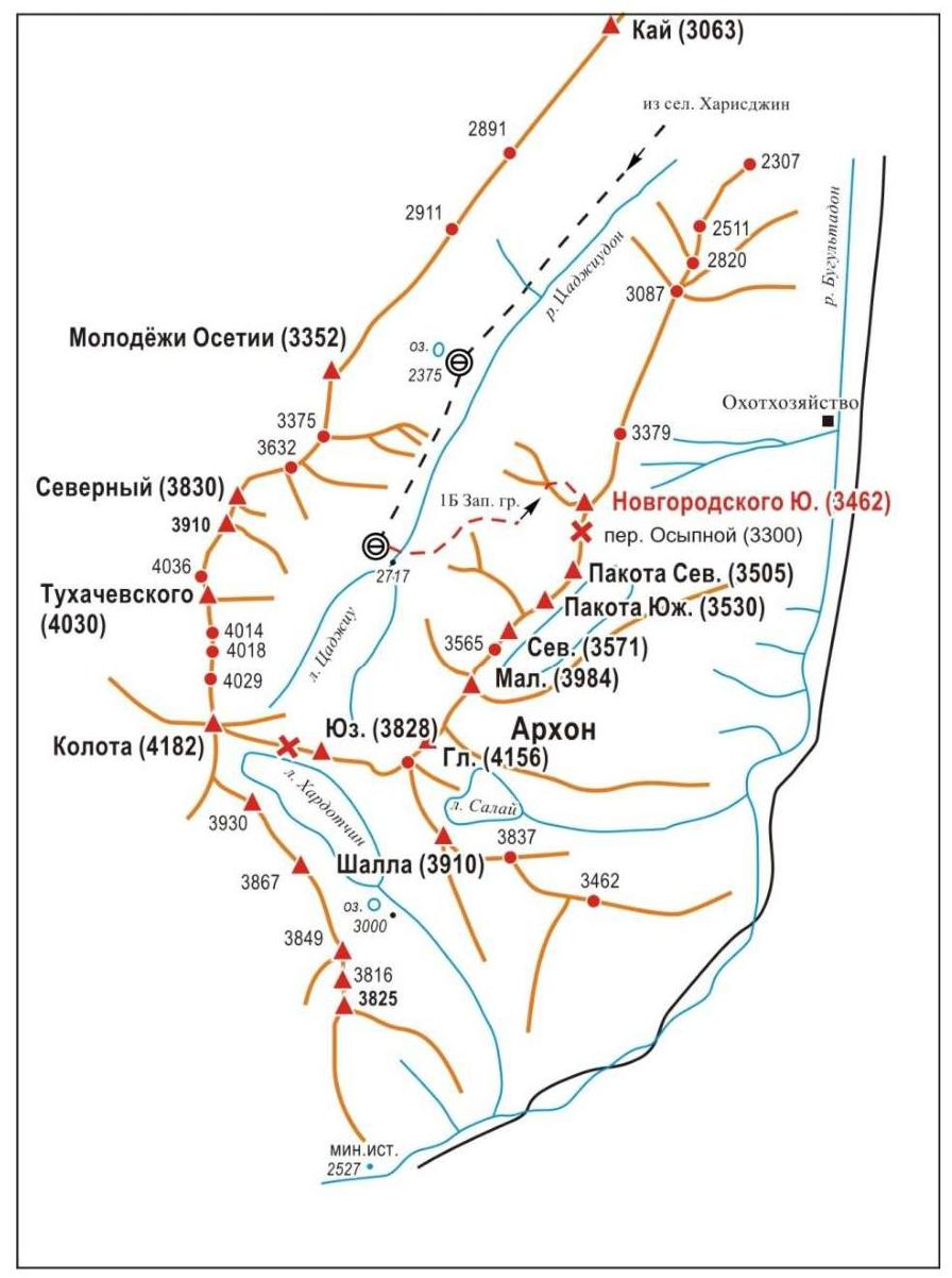
Tsadzhitudon Valley Scheme
Brief Overview of the Ascent Area
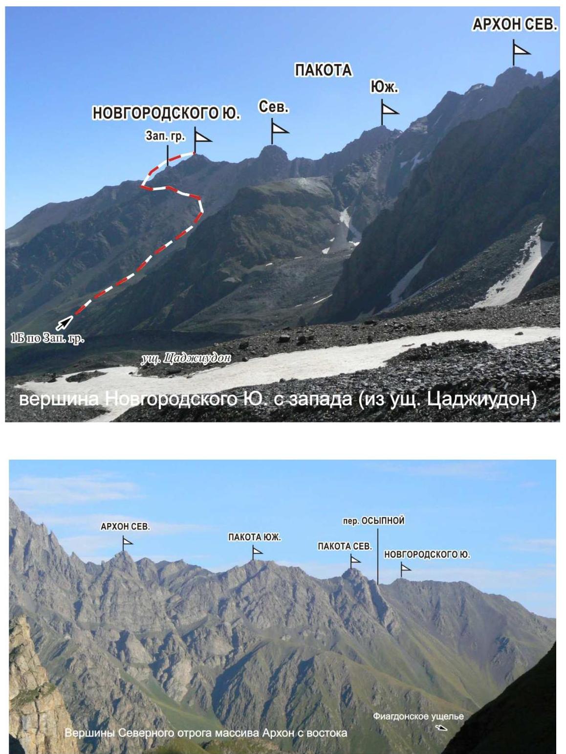
Peak Novgorodskogo Yu. (3462 m) is located in the Tsadzhitudon river valley, at the end of the northern spur of the Arkhon massif. To the south, the peak is bounded by the Osypnoy pass (3300 m), behind which are the peaks Pakota Northern (3505 m) and Pakota Southern (3530 m). To the north, a long rocky ridge stretches, ending in the interfluve of Tsadzhitudon and Fiagdon.
The peak massif is composed of destroyed schists. To the west and east, steep scree slopes descend from the massif, cut by couloirs.
The peak is named after Yuri Alexandrovich Novgorodsky (1940–2009), a well-known mountaineer from North Ossetia: Candidate Master of Sports, instructor 2nd category, winner of the USSR Championship (gold medals) in the class of traverses (traverse of the Sugansky ridge) in 1966, multiple prize-winner of rock climbing championships.
Preparation for the Ascent
In preparation for the ascent, available materials were studied, the peak's location was determined, and a preliminary reconnaissance and assessment of the route, approach path, and bivouac site were conducted, as well as the principle of ensuring radio communication. It was established that it is desirable to maintain radio communication with Vladikavkaz, and mobile communication is possible on the route.
Approach Description
To the bivouac (2700 m), located in the upper reaches of the Tsadzhitudon valley (North Ossetian Reserve), two paths lead. Both start from the village of Kharisdzhin (1400 m).
To the village of Kharisdzhin, one can travel by:
- regular bus "Vladikavkaz-Kharisdzhin" from Avtovokzal No. 2 in Vladikavkaz,
- car.
Path one. From the village, we go along a dirt road along the right bank of the Fiagdon river, passing the fork in the roads to the Arkhon pass. After 1–1.5 km, we approach the confluence of the Tsadzhitudon river into the Fiagdon river. Crossing the Tsadzhitudon river over the bridge, turning right, we ascend along a trail or a steep grassy slope to the ruins of an old tower. Descending to the Tsadzhitudon river, we cross it over stones or a temporary log bridge. Further movement goes left up along a faint trail among dense bushes, leading in 2–2.5 hours to the end of the dirt road in the middle part of the valley.
Further:
- We go along a distinct trail leading along the grassy slopes of the valley floor along the left bank of the Tsadzhitudon river.
- We ascend to a grassy hill to a cattle pen, after which we approach a small mountain lake on the left side of the valley in 30 minutes.
- Near the lake, a convenient bivouac is possible (lower bivouac).
From the village of Kharisdzhin, 4–4.5 hours.
Further movement to the upper bivouac goes:
- Along the grassy, gentle slopes of the valley floor.
- At the end — along a grassy-scree slope of moderate steepness with rock outcrops along the left bank of the river (1 hour).
A convenient bivouac is possible near the source of the Tsadzhitudon river. From the village of Kharisdzhin, 5–6 hours.
When following the first path, difficulties arise:
- When crossing the Tsadzhitudon river in the lower part of the path.
- When moving along the trail among thickets of bushes.
The second path to the bivouacs is preferable.
Path two. From the village, we go along a dirt road along the right bank of the Fiagdon river. After 10 minutes, at the fork in the roads leading to the upper reaches of the Fiagdon valley and to the Arkhon pass, turning right, crossing the Fiagdon river over a stationary bridge, we begin to ascend along a steep serpentine dirt road to the Arkhon pass. This part of the path can be traveled by car. After 1–1.5 hours of movement, a distinct trail branches off to the left from the road along a grassy slope (at this point, the road makes a sharp turn, above which are farm buildings, a stream flows from a narrow valley, a good place for rest). We go along this trail, which turns into a dirt road overgrown with dense grass and bushes, traversing along a grassy slope, entering the Tsadzhitudon valley. In the middle part of the valley, the dirt road ends. Further movement along the valley continues along a trail along the left bank of the Tsadzhitudon river (see path one).
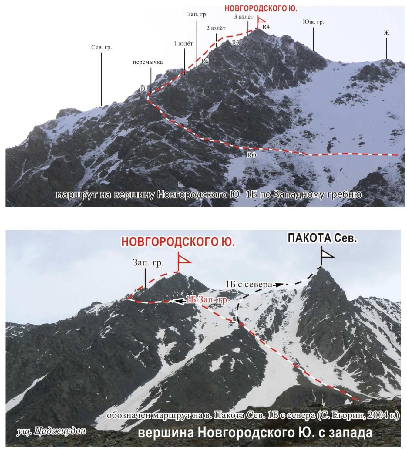
Route Description
From the bivouac in the upper reaches of the Tsadzhitudon valley, turning left, we cross the Tsadzhitudon river over stones. Ascending to the left-bank moraine of the river, we cross to its other side, descending under a large moraine hill on the western side of Pakota Northern peak.
We ascend along a steep scree slope on the right side of the hill. In its upper part, we traverse left up along coarse and medium scree towards a destroyed counterfort descending from a large gendarme located between the peaks Pakota Northern and Novgorodskogo Yu.
Further:
- We ascend onto the counterfort in its wide middle part.
- Descending to the other side of the counterfort, we move left traversing along a steep scree slope to a wide saddle in the middle part of the Western ridge of the peak.
Section R0–R1. The ascent to the saddle goes along destroyed, несложным скалам and steep scree (1–2 category of difficulty, 40°, 80–100 m).
Section R1–R2. Turning right, we ascend along steep destroyed rocks (1–2 category of difficulty, 35–45°, 100 m) to the first ascent of the ridge. We descend from the first ascent to a wide scree saddle under the second ascent.
Section R2–R3. We overcome the second extended ascent along destroyed rocks (2–3 category of difficulty, 40–50°, 170–180 m, key section of the route).
Section R3–R4. The third ascent of the ridge is traversed along destroyed rocks (1–2 category of difficulty, 35–45°, 140–150 m), after which we reach the peak along a simple ridge (120 m). From the bivouac, 5 hours.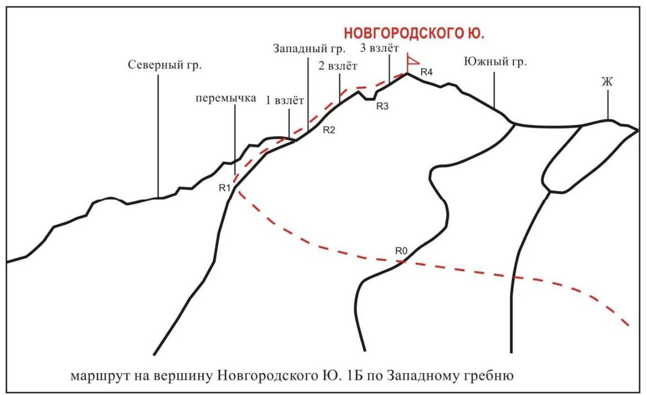
Recommendations
The route is logical, objectively safe, and passable at any time of the year. Belaying on the route is through rock formations. Recommended for training groups.
The descent from the peak goes along the Southern ridge to a saddle between the peak and a large destroyed gendarme. Further, we descend along a wide scree couloir (possibly with snow), exiting left onto a wide part of the scree counterfort.
Photos of the Peak, Route
Peak Novgorodskogo Yu. from the west (from Tsadzhitudon valley)

Peaks of the Northern spur of the Arkhon massif from the east
Start of the 1B West ridge route

R1 First ascent
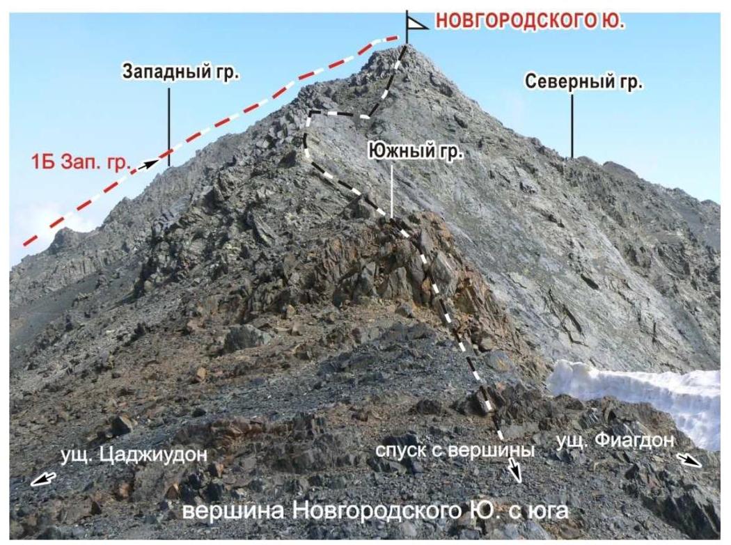
Peak Novgorodskogo Yu. from the south