Traverse of Midadgrabin-Khokh (4040 m) – Tep-Khokh (3926 m) peaks, 4–6 cat. diff. (approximately).
The Midadgrabin glacier area is adjacent to the Kazbek high-altitude area (to the west) and is located in the eastern part of the Central Caucasus. The highest peak in the area (and North Ossetia) is Jimarai-Khokh (4778 m). The massifs of Midadgrabin-Khokh (4040 m) and Tep-Khokh (3926 m) peaks are part of the ridge that bounds the Midadgrabin plateau from the south and branches off from Jimarai-Khokh to the west.
Relief features:
- To the north, the ridge drops sharply with steep icy slopes and rocky walls.
- To the south, it drops with rocky walls.
The rocks that make up the massifs of these peaks are extremely unstable, and the ridge between them is heavily destroyed and very sharp with steep drops.
The traverse was first completed in September 1956 by the "Lokomotiv" group led by L. Tsypkin. It was traversed for the second time also by the "Lokomotiv" group in the same year.
Classification of participants:
- 1st sports category
- 2nd sports category with assignment.
Day 1
The starting point for the ascent is the city of Ordzhonikidze, from where they follow the road through the villages: Gizel, Dargavs, Jimara — to the ruins of the geologists' settlement at the headwaters of the Gizeldon river, 7 km above the village of Jimara. The journey takes 2 hours 30 minutes. The first bivouac is set up at the site of the former geologists' settlement.
Day 2
On this day, it is necessary to travel from the "geologists' settlement" through the tongue of the Midadgrabin glacier to its upper reaches and ascend to the bivouac site at the base of the western ridge of Jimarai-Khokh. The ascent height for the day is approximately 1 km.
From the "geologists' settlement," one must move along a once well-trodden path, making steep turns, gaining height on the right (orographically) bank. High above the river floodplain, the path crosses several gullies and leads to the grandiose "sheep's foreheads," where a pack road is cut.
1.5–2 hours after leaving the bivouac, bypassing the "sheep's foreheads," the path leads to a talus slope where it disappears.
From here, the tongue of the Midadgrabin glacier is clearly visible half a kilometer away, which can be reached:
- by the same slope, cutting steps (when exiting onto the tongue);
- or, even simpler, by crossing to the opposite bank of the river, ascending 100 m along the talus, and exiting onto the left-bank moraine of the glacier, which soon leads to its surface.
The glacier here is calm and safe. One must move along the glacier until it turns east and, following the turn, sticking to the median moraine of the glacier, — in an easterly direction, to the upper reaches. The transition from the tongue to the bivouac site will take approximately 3 hours. The Western rib of Jimarai is a landmark.
When level with the peak of Midadgrabin-Khokh on the glacier, it is necessary to rope up, as the glacier is heavily crevassed here. A bivouac can be organized:
- on the median moraine of the Midadgrabin glacier;
- in the upper cirque of the glacier, near the massifs of Jimarai-Khokh and Suatisi-Khokh (preferably).
To approach this point from the glacier tongue will take approximately 4 hours.
Day 3
The departure from the bivouac is early. They approach the foot of the Tep pass. On ice with a slope of 30–35°, they begin the ascent, overcoming two wide crevasses. Then they pass a steep (up to 40°) icefall, broken by numerous crevasses, between which they must navigate, choosing a path. Finally, they reach the horizontal part of the icefall and, crossing the right-bank crevasse, they traverse the right slope to the foot of the Tep pass, where the icy slope on the left and the rocky ridge on the right converge.
With crampons and with insurance, they ascend 200 m upwards (driving in 2 pitons) to steep and very destroyed rocks. Along them (about 100 m high), they ascend to the Tep pass.
The path from the Tep pass to the peak of Midadgrabin-Khokh initially goes along a heavily destroyed shale ridge with numerous gendarmes, which are taken "head-on" or bypassed. Then the ridge becomes talus for 100 m. Movement along the rocky ridge requires great caution, as the rocks are very destroyed. Thorough insurance is necessary.
Then the ridge becomes rocky and very sharp again, so that for 100 m, one has to "crawl" on top. The danger is exacerbated by the fact that the crest is composed of very destroyed shale rocks.
Further, the ridge is a rocky "saw," with gendarmes taken "head-on." Two gendarmes are encountered, which are bypassed on the right along the steep ice with a descent after each down 2 ropes on ice with a slope of 45–50° with piton insurance (driving in one piton each).
Having overcome the second large gendarme, they reach a snow-ice slope with a slope of 30–35°, which leads to the summit tower of Midadgrabin-Khokh.
The height of the tower is 30–35 m, and the ascent is along a sharp, almost vertical ridge with a sufficient number of holds. Insurance is through rock pitons (two pitons).
Having reached the ridge:
- they pass another rope length along the sharp crest;
- cross a small depression;
- climb to the cairn on the summit.
The path to the saddle between Midadgrabin-Khokh and Tep-Khokh peak is clearly visible. To traverse 3 rope lengths along the sharp, knife-like rocky ridge falling to the saddle (driving in 4 pitons), it takes approximately 3 hours 30 minutes.
Further:
- Descent via rappel 20 m to steep icy and snow-covered rocks at the foot of the tower towards the Midadgrabin plateau.
- From there, the traverse leads to the saddle between Midadgrabin-Khokh and Tep-Khokh.
Here, the third bivouac is set up. From the peak of Midadgrabin-Khokh to the bivouac, it takes approximately 5–6 hours of work.
Day 4
Initially, the path goes along a not-too-difficult destroyed ridge. Then the ridge becomes more challenging and dangerous. It is very sharp, and one has to crawl, sitting on the ridge "astride." Holds are unstable! One must proceed with great caution! Two pitons are driven in for insurance. After 2.5 hours, they approach a gendarme composed of completely disintegrated rock, but due to the lack of bypasses, it is necessary to overcome it "head-on" with thorough insurance.
Having reached the gendarme, they traverse the wall to the left of the ridge and after 10–15 m return to the ridge. Having traversed 1.5 rope lengths, they reach a large gendarme, which is bypassed, and then along a very sharp and destroyed ridge, they reach the summit tower of Tep-Khokh in 30 minutes.
The ascent to Tep-Khokh:
- initially goes along a small ledge to the left to the inner corner;
- then — up this corner.
The descent from the tower is along the same path. The ascent and descent are very dangerous due to the rocks being sheer and very destroyed. Insurance is mandatory.
Further, the path goes to the left, bypassing the false summit of Tep-Khokh along a steep talus, very hard. The gendarmes encountered are bypassed on the left or taken "head-on." Rocks are of medium difficulty.
Not reaching one gendarme to the snow ascent to the peak of Eastern Tsiti:
- ascent along a narrow ice couloir with a slope of 40°;
- beginning of descent with insurance, with the driving in of rock pitons.
Having descended 70 m, they reach a snow-ice slope of the same steepness. They descend along the rocks, and then diagonally — towards the base of the rocky island, crossing a wide couloir. The slope is icy, covered with snow, and is overcome by cutting steps.
During the traverse of the couloir, 3 ice pitons are driven in. Having reached the rocks, they descend down with piton insurance, overcoming several crevasses along the way.
Having crossed the wide bergschrund, along a snow bridge, they exit onto the Midadgrabin glacier and descend along it through the "sheep's foreheads" to the "geologists' settlement." The day's journey takes approximately 10 hours.
Day 5
Return to the city of Ordzhonikidze.
The description was compiled by R. Proskuryakov
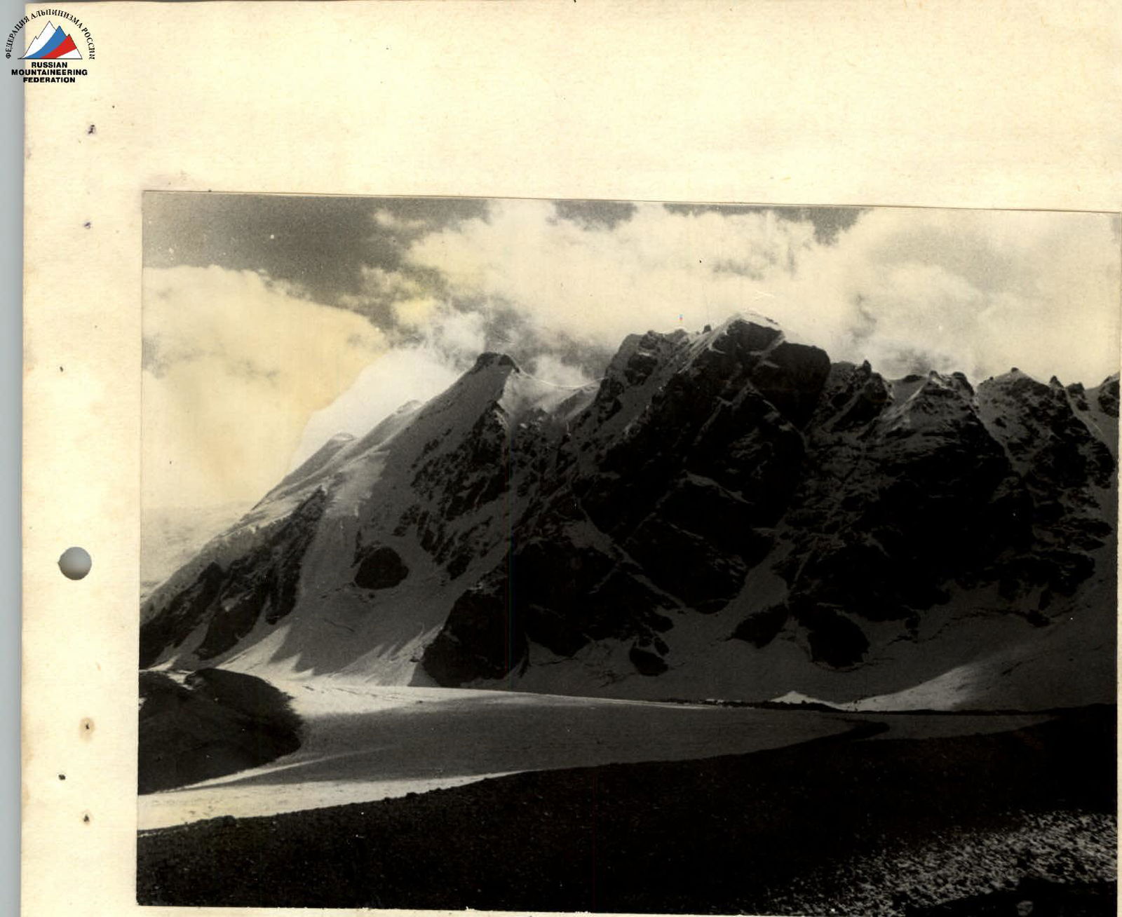
Midadgrabin-Khokh and Tep-Khokh. Photo by R. Proskuryakov.
Sketch map of the ascent on the traverse of Midadgrabin-Khokh – Tep-Khokh.
