Ascent Passport
- Caucasus; Baddon river gorge (right tributary of the Ardon river); section number in the Classification 2.8.
- p. Kvarcevyy (peak Mukhina East ridge) — 3577 m; from the South up the South-East counterfort.
- Category 1B; first ascent.
- Route type — rocky.
- Route elevation gain — 450 m. Length about 900 m. Steepness of key sections is 80°. Average steepness of the whole route is 30°.
- Pitons left on the route — 1.
- Team's travel hours — 4; days — 1.
- Leader: Egorin S.V. — Master of Sports
Participants:
- Karaev M.F. — badge holder
- Klemyonov S. — 3rd sports category
- Coach: Egorin S.V. — Master of Sports
- Ascent date: October 13, 2001
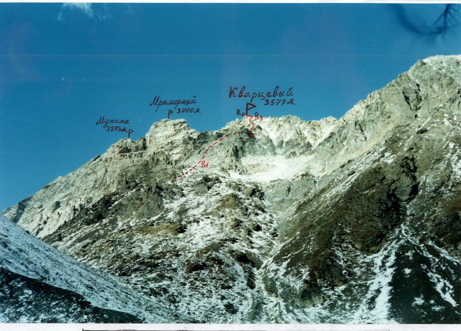
View of p. Kvarcevyy from the South-East. October. The first ascent route is marked.
Overview of the Ascent Area
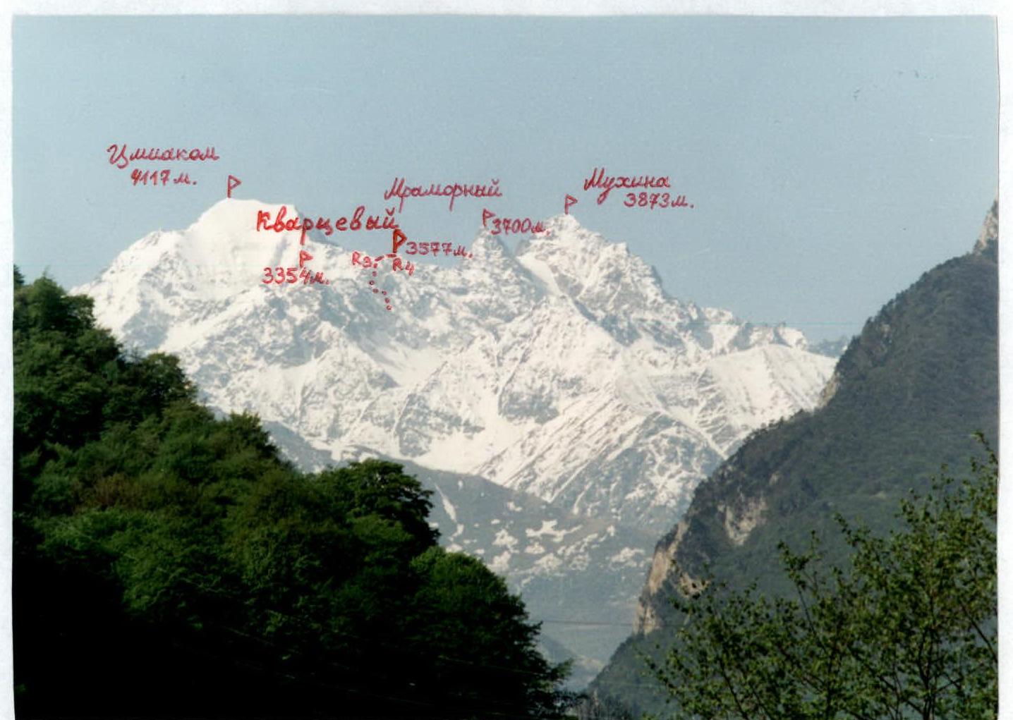
The ascent area is located in the Republic of North Ossetia — Alania in the Baddon river gorge. This river is a right tributary of the Ardon river and flows into it in the settlement Mizur, which is located on the Trans-Caucasian Highway. In the upper reaches, the Baddon gorge becomes wider, and the Baddon river is formed after the confluence of four lateral streams. The westernmost tributary flows from under a small Urusti glacier. It is located under the northern slopes of the East ridge of the highest peak in the Baddon gorge, Cmiakomkhoh (4117 m). To the west of the Urusti glacier is the long North ridge of peak Cmiakomkhoh, which, beyond the Cmiakom and Urusti passes with a small peak 3680 m between them, abuts against the rocky pyramid of peak Mukhina (3873 m). To the north, the Urusti glacier is bounded by the long East ridge of peak Mukhina. In this ridge, the highest peak is the rocky pyramid peak 3700 m — geologists working in this area called it peak Mramorny. Further east are the peaks 3577 m and 3354 m. At the same time, the East ridge of peak Mukhina is the watershed between the Urusti gorge and the smaller lateral gorge of the Baddon river located to the north. The Urusti gorge is poorly explored by climbers. In the 20th century, only two routes were laid to the peaks surrounding the Urusti glacier. In 1959, a group led by B. Ryazhsky ascended Cmiakomkhoh via the East ridge. In 1967, a group led by R. Proskuryakov made the first ascent of peak Mukhina from the South-East.
Tourists have explored the gorge a bit better. Through three passes: Cmiakom, Urusti, and Shkolnik, you can exit into neighboring gorges.
A large number of potential routes to the peaks surrounding the Urusti gorge are still waiting for their first ascenders.
Geologically, the gorge is interesting because sedimentary rocks come into contact with magmatic rocks here. On the slopes of the peaks, it is very interesting to observe how light gray granites with a large amount of quartz abruptly turn into black clay metamorphosed schists. In the Urusti gorge, there are many exploratory mines left by geologists on the slopes.
The climate is typical for the Caucasus in the Lateral Ridge — in the summer, fog and thunderstorms are common after noon. Snowfall in the highlands can occur in any month. Due to the long approaches, the Baddon gorge and the Urusti gorge are rarely visited by climbers.
Photopanorama of the ascent area. May. View from the North-East, from the Trans-Caucasian Highway.
Description of Approaches to the Route
From Vladikavkaz, drive along the Trans-Caucasian Highway (TCH) to the settlement Mizur (1.5 hours). In Mizur, in its upper part, cross the Ardon river to the right orographic bank via the bridge. Walk along the road past the school to the mouth of the Baddon river. Start ascending along the Baddon gorge via a dirt road. The road is partially cut into the rocks and runs along the canyon. Soon the gorge widens, and after some time, we approach the village Bad — the only inhabited village in the entire gorge (about 1.5 hours from Mizur).
Further up the gorge, follow the old geological road. The road initially runs through the forest, then through clearings, and, after reaching the alpine meadows, soon ends. From the village Bad to the end of the road, the path lies along the right (in the direction of travel) bank of the Baddon river. If you have high-clearance vehicles, you can drive from the TCH to the end of the road by car.
Then, from the meadows where the road ended, descend into the river floodplain. Walk along the Baddon river upstream along the stones towards the canyon. Before reaching it, turn right and start ascending along a mudflow gully towards the visible waterfall on the sheer rocks above. After ascending 150–200 m from the river, turn left and exit onto an old geological road overgrown with trees. Follow it to bypass the canyon along the right (in the direction of travel) bank. Continue along the remains of the road upstream along the gorge above the river. We bypass a rocky outcrop near the river on the right via the road's serpentines.
After passing a road bend, we find ourselves above a wide grassy floodplain of the river — the confluence of streams from lateral gorges that form the Baddon river. We need to turn into the rightmost (in the direction of travel) lateral gorge — the Urusti gorge. It takes 5–6 hours from the TCH to the fork in the gorges.
Turning right, we ascend up the grassy slopes to the right of the Urusti stream. The path sometimes follows trails on the slope or an old overgrown geological road. After covering a third of the gorge, when ridges with rocky walls appear on both sides, limiting the gorge, walk up the road towards the visible ridge of an ancient terminal moraine ahead. After reaching it, continue along the scree moraine ridge, passing old geological exploratory mines on the left. After some time, we approach a lake near the glacier tongue, where there are scree areas suitable for overnight stay. Elevation 3000 m. It takes 8–9 hours from the TCH, with a height gain of 2000 m.
Route Description
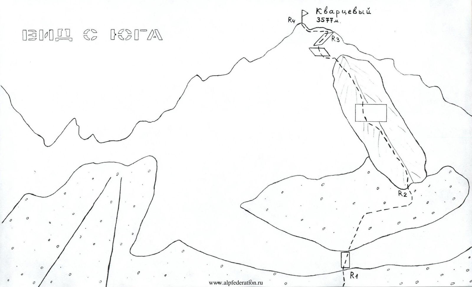
From the overnight stays near the lake, ascend to the lateral moraine ridge and walk along it above the Urusti glacier. The gorge is bounded on the left by the northern wall of the East ridge of peak Cmiakom, and on the right by the southern slopes of the East ridge of peak Mukhina. Immediately to the east of peak Mukhina (3700 m) in the ridge lies peak Mramorny (3700 m). When viewed from below, these two peaks appear as rocky towers with walls facing south. To the east of them, in the same ridge, is located peak Kvarcevyy. It has rocky wall outcrops only in its upper part — below the summit. Below, its southern slopes are mostly scree. After reaching a large flat stone lying directly on the trail along the moraine ridge, turn right, to the north. Here, we find ourselves at the base of a scree gully separating peak Mramorny (3700 m) on the left and peak Kvarcevyy (3577 m) on the right. R0–R1: The ascent path follows the scree slope to the right of the gully. The direction of movement is to the right and upwards towards the saddle. Along this scree slope, with rock outcrops 1, we approach the rocky belt after about 350 m. From point R0, it appears as a ridge against the sky, extending from the summit to the right. R1–R2: Overcome the rocky belt to the right and upwards through a 15 m wall, 2–3. After it, ascend 50 m upwards and then move to the right through a slope inflection. After reaching scree ledges that drop off to the east with sheer faces, we turn left and approach the base of the South-East counterfort. The entire section is about 200 m, 1–2. R2–R3: Follow the wide South-East counterfort 1–2, bypassing complex sections via ledges, to ascend. Pass a 3 m wall in the middle of the counterfort on its left side — 10 m. Continue towards the summit. Bypass the summit tower on the right and, through numerous quartz fragments found on the ledges, exit onto the East ridge of the summit. The entire section is about 300 m. R3–R4: Along the East ridge 1–2, after 50 m, ascend to the summit of peak Kvarcevyy (3577 m). The summit is clearly defined, offering a good panoramic viewpoint to the north, east, and south. The peaks of the Skalisty Ridge, Kalota "saw", Tepli, and Cmiakom are visible. No signs of human presence were found. It takes about 5 hours from the lake to the summit, with a height gain of 600 m. Descent is via the ascent route.
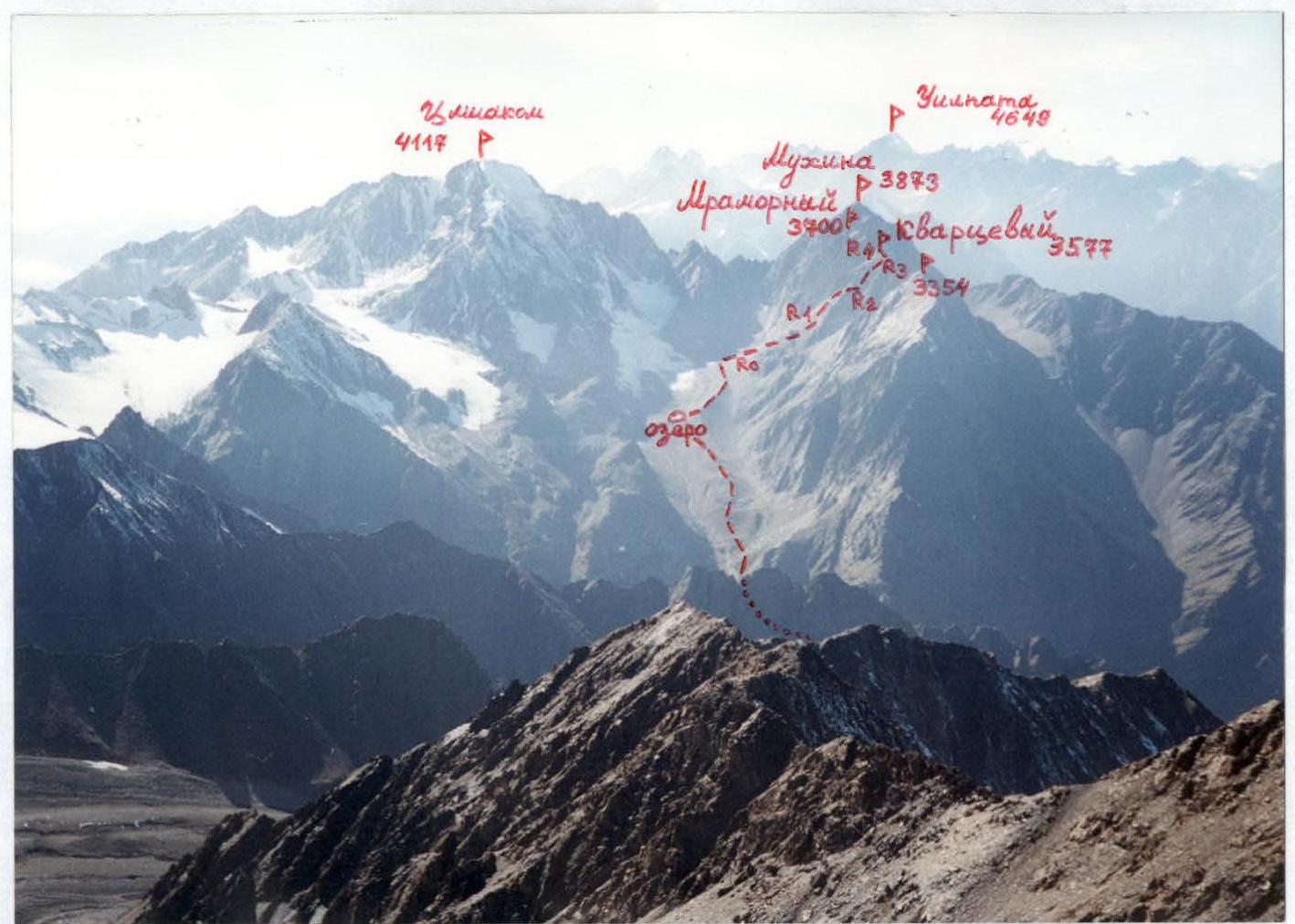
Photopanorama of the ascent area. September. View from the East, from peak Tukhachevsky (Rostovchan).
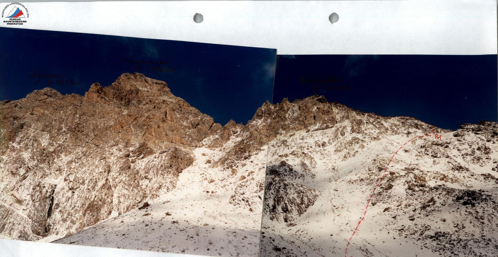
View of peak Kvarcevyy from the South. October. The first ascent route is marked.