
Zilga-Khokh Main via Eastern Ridge, 2B–3A category of difficulty
The summit is located in the eastern part of the Central Caucasus. The beautiful double-peaked Zilga-Khokh massif rises at the junction of the Main Watershed Ridge and the ridge of submeridional orientation, which is a continuation of the chain of Sivaraut peaks (southwestern spur of the Midagrabin horseshoe). Zilga-Khokh is directly adjacent to the peaks:
- Vatsis-Pars (3400 m) to the north,
- Kalasan (3780 m) to the east.
The massif has the appearance of a paired cone with two peaks - the Main peak (3853 m) and the western peak (3820 m) - a nodal peak, reminiscent of Kamchatka volcanoes in shape. From the saddle, a small cirque glacier descends to the north with a beautiful icefall in the middle reaches. A cirque glacier, partially littered with rock debris, is located east of the massif. The streams flowing from these glaciers give rise to the Terek River, from the upper reaches of which it is most convenient to ascend to the peaks of Zilga-Khokh.
The Terek River flows for about 30 km to the east, separating the Watershed and Lateral ridges of the Caucasus. The gorge is called Trussov. The gorge is notable for its abundance of narzan springs of different fountaining and mineral composition. There is even a narzan lake. This testifies to the extinct, once active, volcanic activity in the area.
The peak was first conquered in 1911 by Fisher and Schuster. The first Soviet ascent was made on July 30, 1938, by a group from the Moscow Regional Department of Light Industry under the leadership of Uspensky and Semenov. The distant peak in the upper reaches of inaccessible gorges was visited for the third time from the Vatsis-Pars pass by geologists from the Sevkavtsvetmetrazvedka trust, Ozeryin V.V. and Botsiev T.I., on July 9, 1969, whose note was retrieved on August 26, 1972, by a group of climbers from Ordzhonikidze under the leadership of Proskuryakov R.P., who traversed the Eastern ridge of Main Zilga-Khokh and descended along the southeastern ridge.
A narrow and sometimes dangerous road is laid along the Trussov gorge, not always accessible to medium-cross-country vehicles. It is most convenient to pass through the gorge early in the morning or late in the evening, when the melting of glaciers decreases sharply and the water level in the Suatisi, Tep, Resi, and Terek rivers is not high. A relatively decent road goes from the village of Kobi on the Military Georgian Road to the mouth of the Suatisi-Don River (left tributary of the Terek), and further along the Terek River floodplain, a dirt road is laid, which, disappearing and reappearing, leads to the ruins of the village of Tep, beyond which it disappears altogether.
The further path is on foot along a good trail, trodden along the right bank of the Terek River.
After 2-3 km, the gorge turns left and narrows. It is more convenient to walk along the right bank of the river. Another 1 km of walking - and the trail disappears completely; the path goes along the Terek River floodplain, which merges in the upper reaches from two streams:
- The right tributary flows from under the glacier, descending from the saddle cirque between the peaks of Zilga-Khokh.
From the confluence of the streams, one should go along the moraine hills to the south, to the eastern cirque glacier of Zilga-Khokh, and on the hilly plateau, organize an overnight stay (1.5 hours' walk from the fork).
From here, the ridge of Zilga-Khokh, Kalasan, and the upper reaches of the glacier are clearly visible.
Near the overnight stay, to the west, the Eastern ridge of Zilga-Khokh is clearly visible, with a convenient exit to the ridge along a wide scree terrace.
The Eastern ridge from the terrace goes steeply upwards, with an average steepness of 45°, composed of rocks and scree of large-block light aplites. The latter protrude on the steep ridge, forming 1.5-2-meter gendarmes. To the north, the ridge drops off with slabs up to 70-85° steepness, as the shale strata are set almost vertically. The ridge is very narrow, and it is necessary to move along it very carefully, as the debris lies on a steep monolithic base very unsteadily, and from each careless movement, the mass begins to slide.
The route length is 300-350 m. On the mentioned scree terrace, it is necessary to rope up. For a length of 50-70 m, the ridge is wide. The bedrock is covered with a shallow layer of fine scree (move carefully!). The movement is simultaneous with the rope being laid around outcrops.
Further movement along the ridge is complicated by gendarmes composed of steep shale blocks.
The first palisade of gendarmes on the ridge, about 40 m long, is bypassed on the left, using grips on the rocks of the gendarmes; insurance through outcrops.
Further, along несложным скалам перейти влево на дайку светлосерых твердых пород, тянущихся параллельно гребню. Through 2 ropes of not difficult climbing along rocks with a steepness of 50°, it is necessary to return to the ridge line, as the steepness of the slope increases to the left, and the strong light rocks are wedged out.
Another 2-3 ropes are passed with a detour around the encountered gendarmes on the left and right with the rope being laid around outcrops, with an exit to a saddle in a break in the ridge, where it is possible to rest comfortably. Above the site, after 2 ropes (fine scree), the slope becomes gentler. From the pre-summit ridge to the northwest, a glacier flows down, forming an ice remnant on the ridge. Overcoming it is on crampons with insurance through ice screws. The length is 2 ropes, steepness 35-40° in the lower part, in the upper part it becomes gentler to 30°. In the absence of snow, it is possible to traverse the steep scree slope near the ice boundary on the southern side. Insurance is the same. After 40-50 m - the summit. Descent is possible both along the ascent route and along the southeastern ridge in the upper reaches of the cirque of the same eastern cirque glacier. From here, it is 30 minutes' walk to the bivouac. The descent to the bivouac will take about 1.5 hours.
Equipment required for a group of 4 people:
- Main rope 30 m - 2 ends.
- Crampons 1 pair
- Ice screws 3 pcs.
- Hammer 1 pc.
The description was compiled by:
Photo by R. Proskuryakov.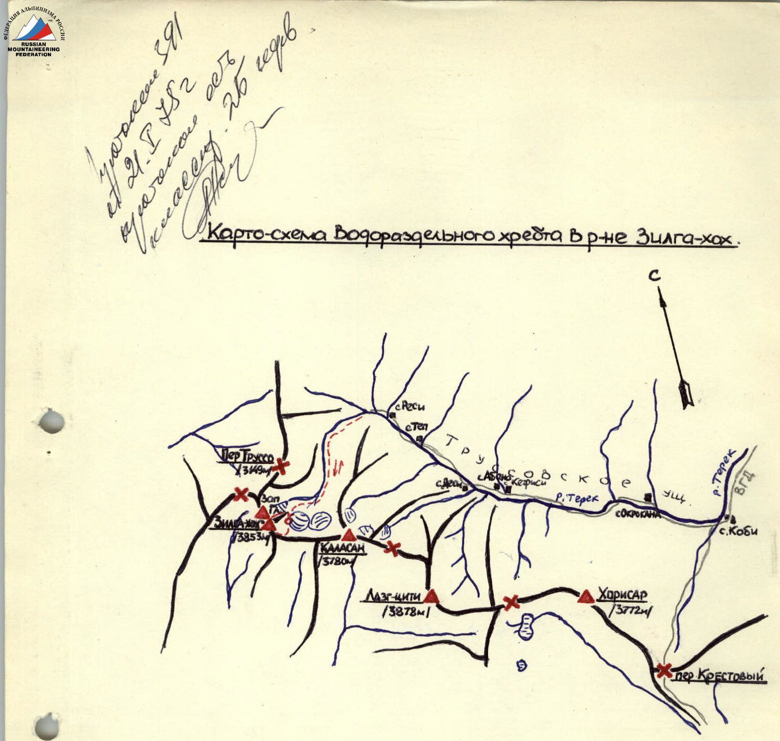
- route of the group /on foot/. б -
bivouacs.

Comments
Sign in to leave a comment