Report
on the first ascent to the top of Zamaraeva, along the South-West ridge, category 1B difficulty, by the team of the North Ossetian Rescue Squad of the Ministry of Emergency Situations of Russia and Tsentrospas on July 6-7, 2019 2019
1. Ascent Passport
| №№ | 1. General Information | |
|---|---|---|
| 1.1 | Full name, sport rank of the leader | Egorin S.V. — Master of Sports |
| 1.2 | Full name, sport rank of participants | Chikin A.B. — 2nd sports rank, Grozovsky O.V. — 2nd sports rank, Kulchiev A.S. — 3rd sports rank, Arakelyants V.M. — 2nd sports rank, Dultsev G.A. — Candidate for Master of Sports, Kondrashov D.V. — 1st sports rank, Staritsky P.G. — 1st sports rank |
| 1.3 | Full name of the coach | Egorin S.V. |
| 1.4 | Organization | FARSO-Alania and Ministry of Emergency Situations of Russia |
| 2. Characteristics of the Ascent Object | ||
| 2.1 | Region | North Ossetia, Tsiakom - Tepli region |
| 2.2 | Valley | Tsiakom |
| 2.3 | Section number according to the 2013 classification table | 2.2.8 |
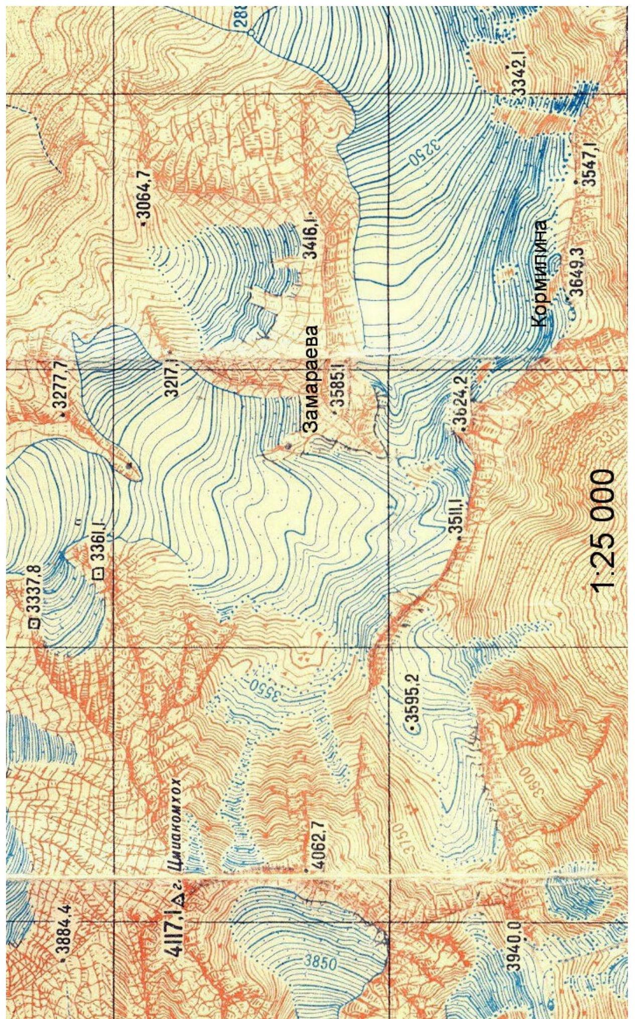
| 2.4 | Name and height of the peak | Zamaraeva 3585 m |
| 2.5 | Geographical coordinates of the peak | 42°44.6′ N 44°04.0′ E |
| 3. Characteristics of the Route | ||
| 3.1 | Name of the route | South-West ridge |
| 3.2 | Proposed category of difficulty | 1B |
| 3.3 | Degree of route exploration | First ascent |
| 3.4 | Relief characteristics of the route | Rocky |
| 3.5 | Height difference of the route | 200 m |
| 3.6 | Length of the route | 300 m |
| 3.7 | Technical elements of the route | I cat. diff. ice/rock/combination — 100 m. II cat. diff. ice/rock/combination — 100 m. III cat. diff. ice/rock/combination — 80 m. IV cat. diff. ice/rock/combination — 20 m. Movement on a closed glacier — none. Rappelling (on descent) — 80 m. |
| 3.8 | Descent from the peak | Via the ascent route |
| 3.9 | Additional characteristics of the route | Presence of water (snow below the pass) |
| 4. Characteristics of the Team's Actions | ||
| 4.1 | Time of movement | 5 hours |
| 4.2 | Overnights | none |
| 4.3 | Departure on the route | 5:00, July 7, 2019 |
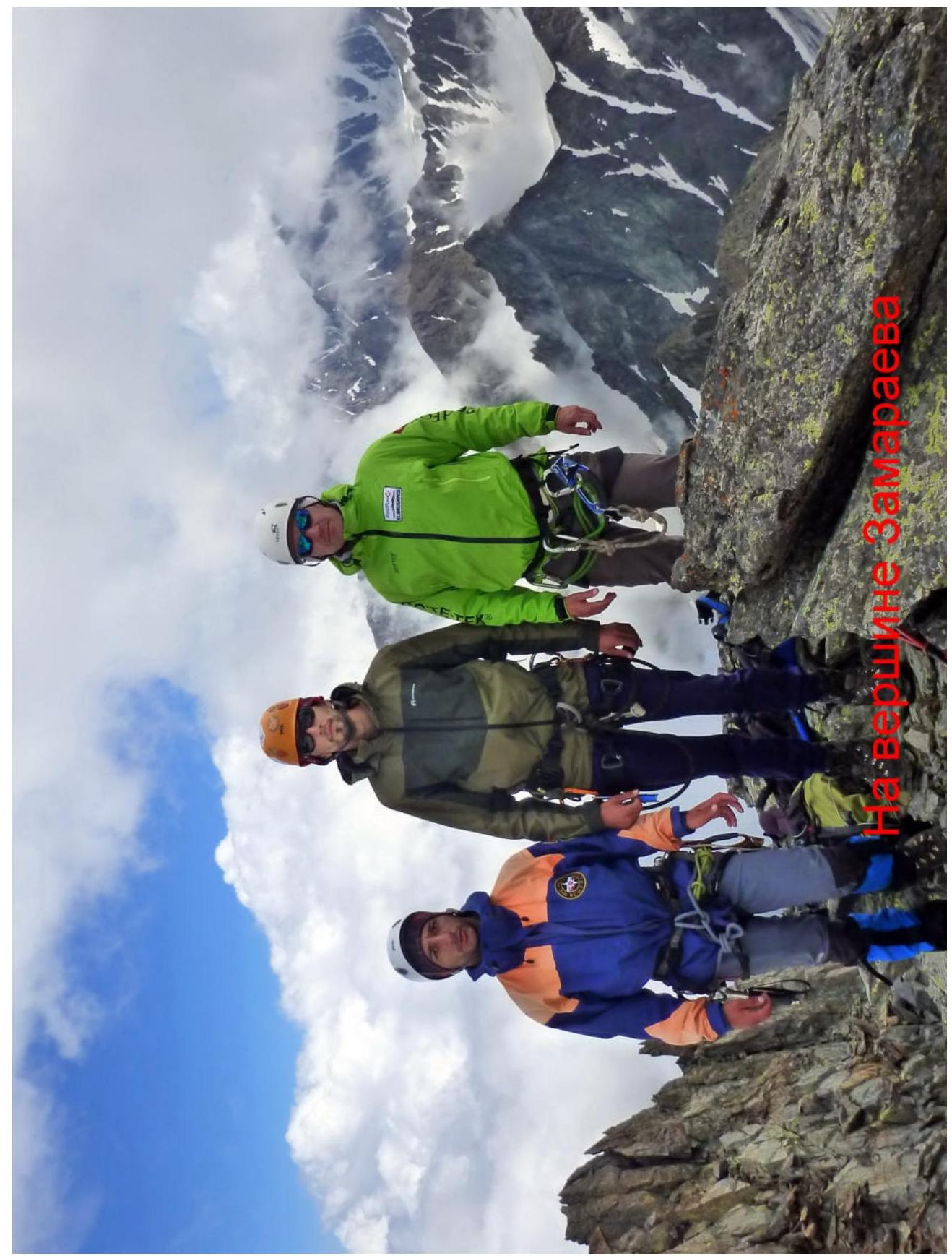
| 4.4 | Reaching the peak | 10:00, July 7, 2019 |
| 4.5 | Return to the base camp | 14:00, July 7, 2019 |
| 5. Person Responsible for the Report | ||
| 5.1 | Full name, e-mail | Egorin S.V., e.s.128@mail.ru |
 3948.0 3948.3 3947.1
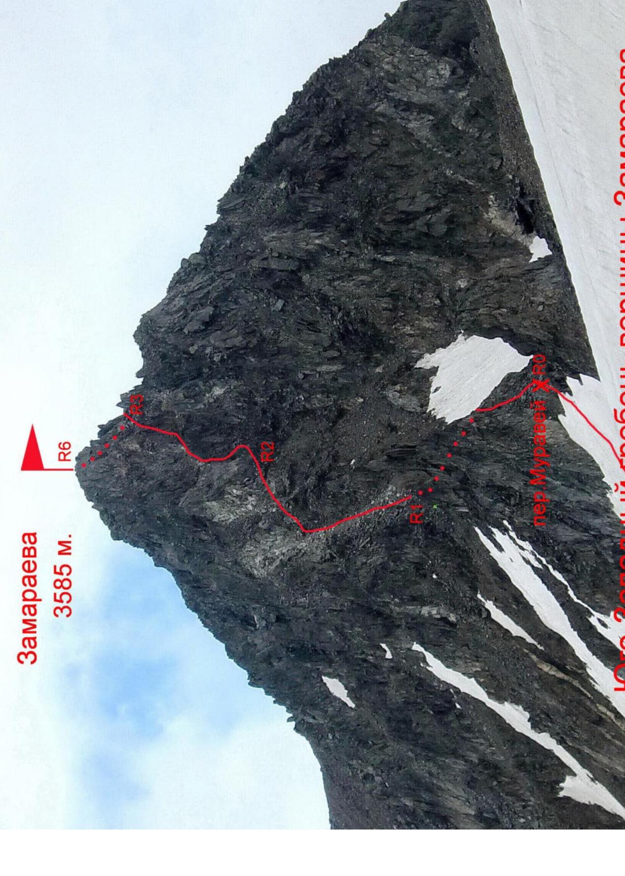
2. Technical Characteristics of the Route Sections
| Section | Relief Characteristics | Category of Difficulty | Length, m | Type and Number of Pitons |
|---|---|---|---|---|
| R0–R1 | Rocky-talus ridge | 1–3 | 100 m | - |
| R1–R2 | Rocky-talus destroyed ridge | 1–2 | 80 m | - |
| R2–R3 | Rocky inner corner | 2–4 | 50 m | 3 wedges |
| R3–R4 | Talus couloir | 2 | 20 m | |
| R4–R5 | Rocky inner corner | 2–4 | 30 m | 2 wedges |
| R5–R6 | Rocky ridge | 1–2 | 20 m | - |
3. Characteristics of the Team's Actions
3.1 Description of Approaches to the Route
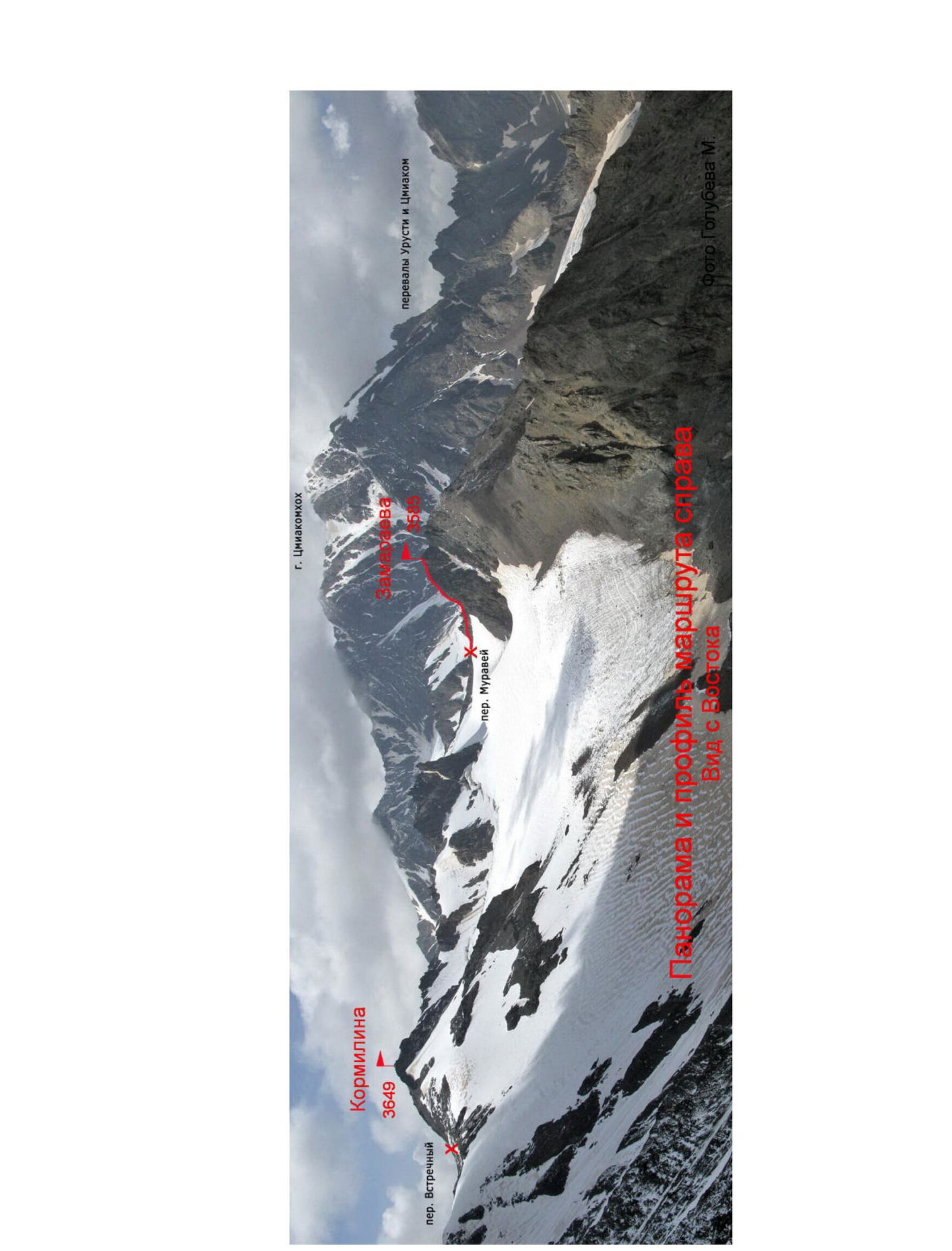
From the city of Vladikavkaz to the beginning of the Tsiakom valley, it's about 120 km along the Transcaucasian Highway. At the beginning of the valley, we drive through the village of Tsi. Behind the village, after fording (driving across with a car) the river, we start moving along the right bank of the river. The road ends after some time, and the path goes along a trail. After a steep ascent to the left, "on the other bank of the river, a corral is visible" — under it, a bridge across the Tsiakomdon river. After crossing the river via the bridge, we move along the left bank of the river.
The valley gradually turns north, and the peak of Kormilin 3649 m is visible ahead. First through meadows, "then through overgrown moraine ridges" we move under the southern ridge — a counterfort of this peak. Not reaching its base, at an altitude of 2800 m — overnight stay. Water is available to the left in the river. From the end of the road, the ascent is 1 km, and the approach takes around 4–5 hours.
From the overnight stay location, we head into the left cirque, under the Strekoza pass. The pass, with a height of 3480 m, is visible from the overnight stay location as the lowest saddle in the left part of the ridge. We reach the pass via a snowy-talus southern slope. In its upper part, in the first half of summer, the following may be necessary:
- crampons
- ice axes
From the Strekoza pass to the north, the rocky pyramid of the Zamaraeva peak is visible. For further approach to it, we descend from the pass into a snowy depression and traverse along the snowy slope to the right, towards the Muravey pass. We ascend to the Muravey pass via a 30–40° slope, with rocks in the upper part.
3.2 Brief Description of the Route Passage
| Section | Description | Photo Number |
|---|---|---|
| R0–R1 | After reaching the pass, we turn left. Along rocky-talus ledges to the right of the ridge line, we move to the saddle behind a rock pinnacle. | |
| R1–R2 | From the saddle of the ridge, we move upwards along the destroyed ridge — slope. Movement is to the right of the ridge line. Before a wall of gray rocks, we turn right to the base of a rocky inner corner. | |
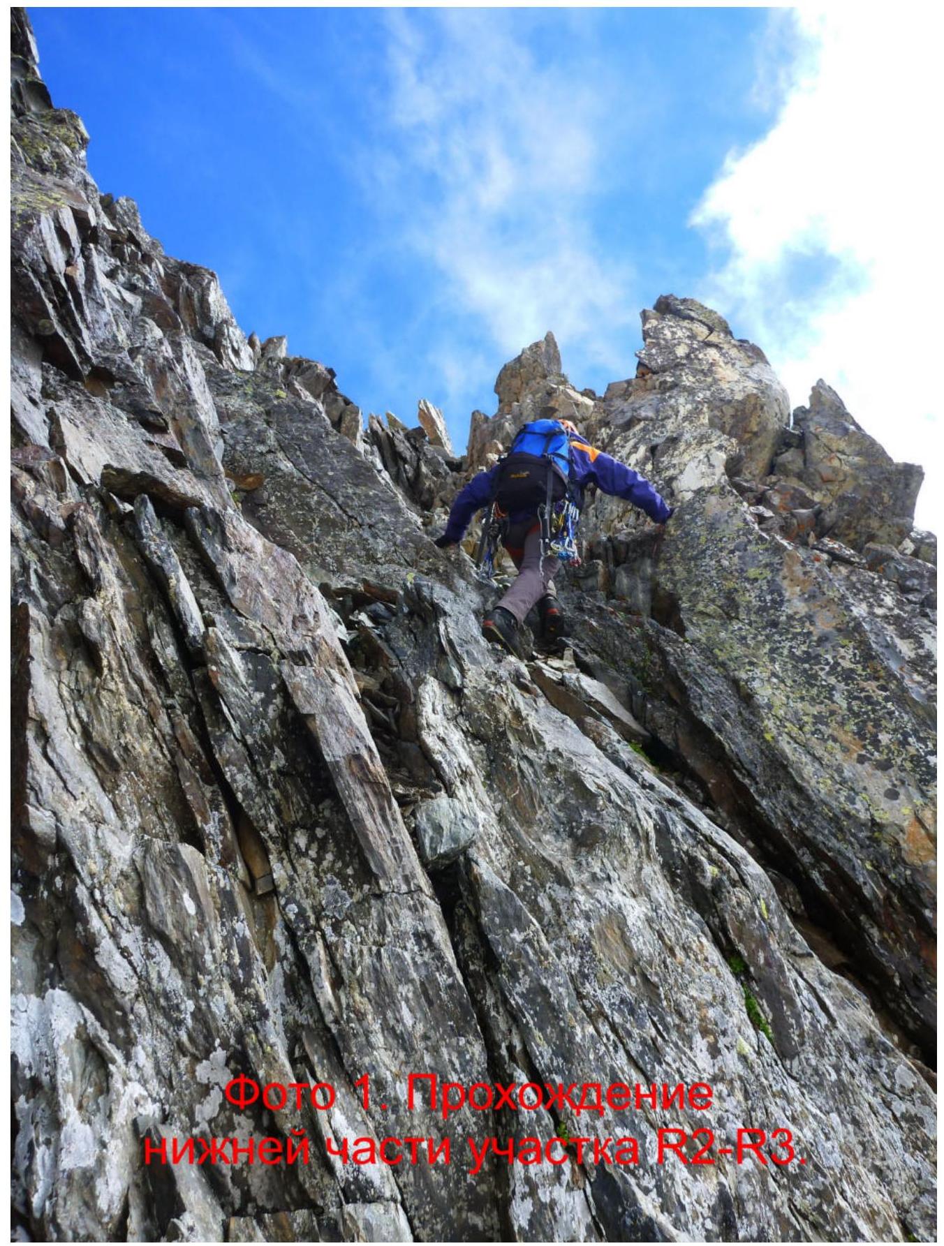
| R2–R3 | Along a wide rocky inner corner directly upwards, towards the saddle against the sky. | Photo 1–2 |
| R3–R4 | The pre-summit rock pinnacle is bypassed to the right. To do this, we descend along a rocky-talus couloir to the right and down, to the base of the inner corner — a chimney. | |
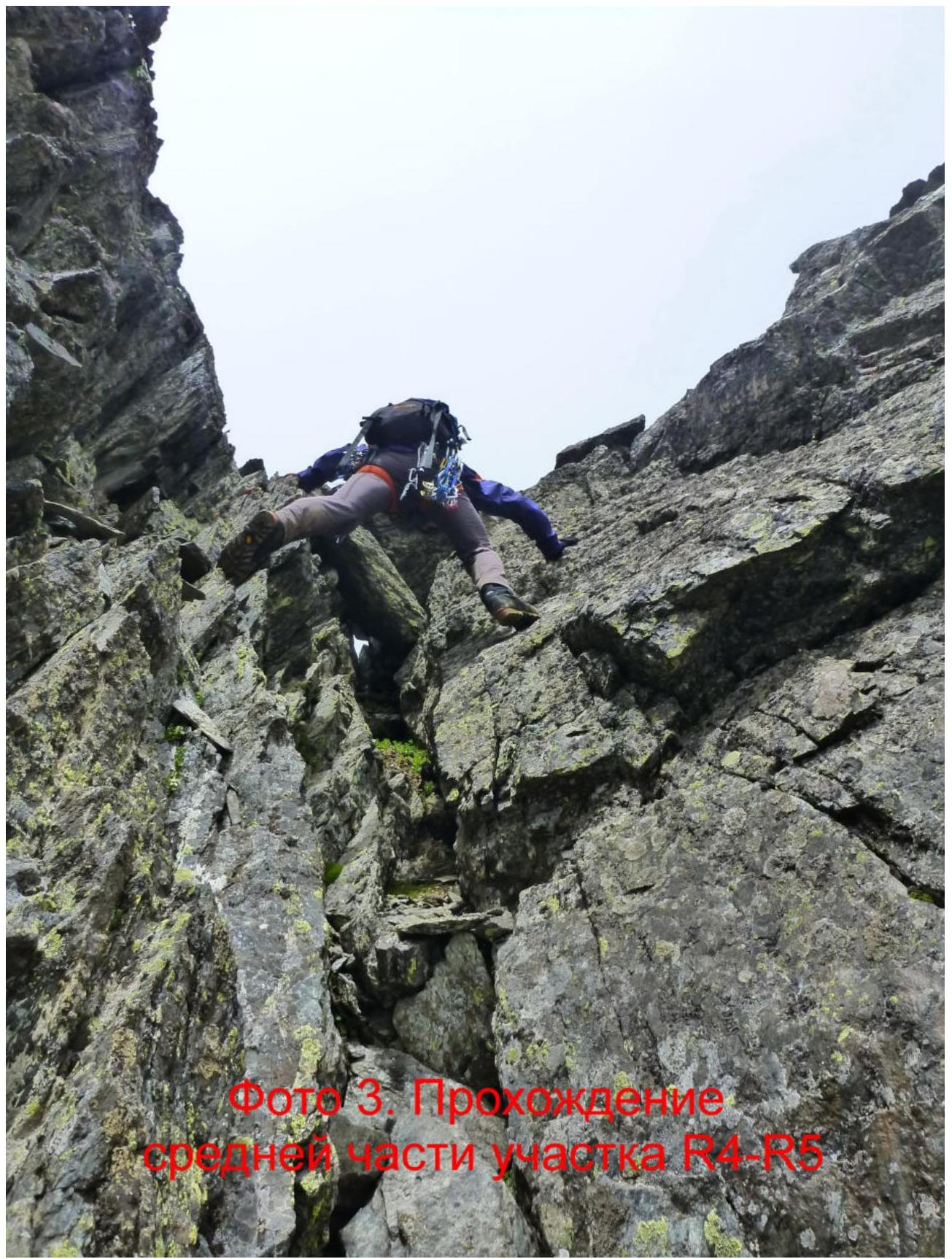
| R4–R5 | From the couloir, we turn left upwards, and along the inner corner (live rocks!) we reach the summit ridge. | Photo 3 |
| R5–R6 | On the ridge, we turn right, and along the rocky ridge, we ascend to the Zamaraeva peak. |
3.3 Recommendations
Descent from the peak is via the ascent route with rappelling on steep sections. There is no cell phone coverage on the route.
The passed route along the South-West ridge is safe when following the description and corresponds to category 1B difficulty.

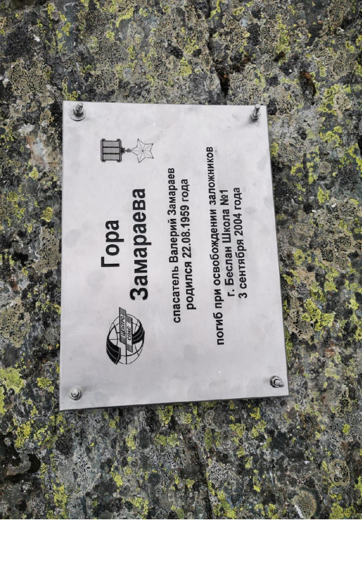
Zamaraeva Peak
rescuer Valery Zamaraev was born on August 22, 1959
died during the rescue of hostages in Beslan, School No. 1
September 3, 2004
Government of the Russian Federation
Decree
dated July 7, 2018 № 1395-r, Moscow
In accordance with the Federal Law "On Names of Geographical Objects" and based on the proposal of the Parliament of the Republic of North Ossetia — Alania, as well as to commemorate the memory of the Hero of the Russian Federation V. V. Zamaraev, who made a significant contribution to the development of rescue operations in Russia, and holder of the Order of Courage D. I. Kormilin, who contributed to the organization and development of the diving service of the Ministry of Emergency Situations of Russia, assign the following names to unnamed geographical objects located in the Tepli massif of the Main Caucasian Range on the territory of the Alagirsky district of the Republic of North Ossetia — Alania:
"Zamaraeva" — to an unnamed mountain with coordinates 42°44.6′ north latitude, 44°04.0′ east longitude, and an absolute height of 3585 m;
"Kormilina" — to an unnamed mountain with coordinates 42°44.1′ north latitude, 44°04.3′ east longitude, and an absolute height of 3649 m.
Chairman of the Government of the Russian Federation  D. Medvedev