Climbing Passport
- Climbing area: North Caucasus, Midagrabin gorge
- Peak name — route name: ZEYGALAN (4244 m) — Left buttress of the western wall
- Proposed: 5B category of difficulty, first ascent
- Route type: combined
- Route height difference:
- Route length: 1300 m
- Length of sections with V category: 215 m
- Length of sections with VI category: 85 m
- Average steepness of the main part: 70°
- Average steepness of the entire route: 58°
- Pitons left on the route: 6 pcs.
- including bolt pitons: 0 pcs. Used on the route:
- rock pitons: 61, including for ITO: 6
- stationary bolt pitons: 0, including for ITO: 0
- removable bolt pitons: 0, including for ITO: 0
- chocks: 69, including for ITO: 8
- friends: 68, including for ITO: 3
- ice screws: 13, including for ITO: 0
- Team's total hours: 39 h, 4 days
- Team leader: Ryzhanov Oleg Nikolaevich, Candidate for Master of Sports Team members: Gudenko Evgeny Vladimirovich, 1st sports category Kudinova Vera Viktorovna, 1st sports category Chupin Vyacheslav Mikhailovich, 1st sports category
- Coach: Ryzhanov Oleg Nikolaevich
- Departure to the route: 7:00, September 8, 2003 Summit: 16:00, September 11, 2003 Return to base camp: 20:00, September 11, 2003
- Organization: Mountain club "KASKAD"; FSO Alania.
General Photo of the Summit

The following routes are marked on the photo:
- v. Zeygalan from Midagrabin glacier, 1B
- p. 8 Marta, 5A, 1999, Khamitsaev K.B.
- v. Zeygalan via western ridge, 2003, Ryzhanov O.N., 2B*
- Route climbed by the team
The photo was taken from a helicopter during an overflight of the Midagrabin gorge on October 10, 2001, from a height of 3700 m.
* — the route is not classified, climbed during route reconnaissance.
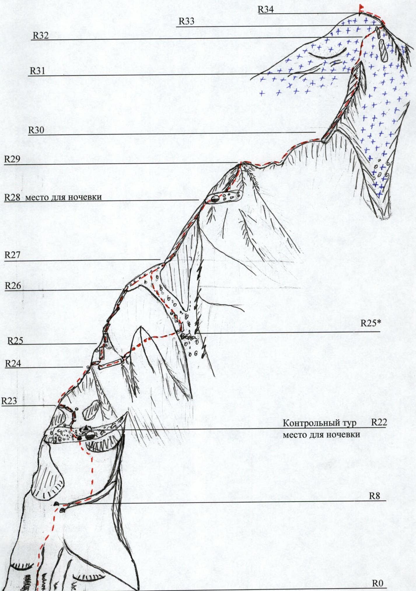
Photo of the Route Profile from the Right
- route line
- overnight stops on the route
Heights of marked sections:
- R0 — 2930 m
- R8 — 3080 m
- R22 — 3360 m
- R28 — 3800 m
The photo was taken from a helicopter during an overflight of the Midagrabin gorge on August 24, 2003, from a height of 3600 m. The main part of the route is visible. The upper part of the northern ridge and the ice dome of the summit are not visible in the photo. These photographs are provided in the supplements section (Photo No. 1).
Hand-Drawn Profile of the Route
- route profile
- steepness of the main part: 70°
- steepness of the route: 58°
- R34 (4244 m) v. Zeygalan
- R33 (4150 m) Summit ridge
- R30 (3980 m) start of the ice section (p. 8 Marta)
- R28 (3700 m) Second overnight stop
- R26 (3500 m)
- R22 (3360 m) first overnight stop, control tour
- R8 (3080 m)
- R0 (2930 m)
Panoramic Photo of the Area

- Mt. Kazbek (5033 m)
- Mt. Shau-Khokh (4636 m)
- Mt. Jimarai (4770 m)
- v. Zeygalan (4244 m)
- p. 8 Marta
- Mt. Suatisi (4464 m)
- A-K Midagrabin (glacier)
The photograph was taken from a helicopter during an overflight of the Midagrabin gorge in August 2005 from a height of 4000 m.
Map of the Climbing Area

Description of the Area and Approaches to the Route
The peak Zeygalan (4244 m) is located in the Lateral Ridge of the Central Caucasus. The southern slopes of the peak are gentle and heavily destroyed, descending to the middle part of the Midagrabin glacier. The western slope drops off with a sheer wall into the gorge of the Midagrabin-Don River and blocks the cirque of the glacier. On the peak's northwest wall is a hanging glacier with the well-known Midagrabin waterfall, over 700 m high. Routes from the first to the fourth category of difficulty have been laid and classified to the peaks of the Midagrabin horseshoe: Jimarai, Suatapos, Midagrabin, Tep, Tsiti, and p. Gaponenko. The area was used for organizing alpine camps. Several popular tourist routes also pass through the Midagrabin glacier. A peculiarity of the area is the rapid deterioration of weather in the second half of the day and prevailing strong southern winds.
From the city of Vladikavkaz to the settlement of Jimara leads an asphalt, and then a dirt road. Approximately 2 hours by bus. From the settlement of Jimara along a dirt road along the Midagrabin-Don River 7 km to the border guard post. There is no further road. Follow the remains of the geologists' road towards the "Barany Lby" (Ram's Foreheads), which are clearly visible as a step in the gorge. The start of the ascent to the "Barany Lby" is from a large stone to the left and upwards along the grassy slopes. The left edge of the shelf above the foreheads serves as a landmark. Under the foreheads, cross the scree couloir in its upper part. From the start of the ascent — 1.5 hours. Further, above the large stone in the couloir begins a good trail along the "Barany Lby". 1.5 hours along the trail to the expansion of the gorge. Under large stones are stationary overnight stays. Base camp.

Photo 1
The photo is taken from the opposite slope of the Midagrabin-Don River gorge. February 2003. The main part of the route is visible. The lower part of the route (sections R0–R5) is shown in Photo 1a.
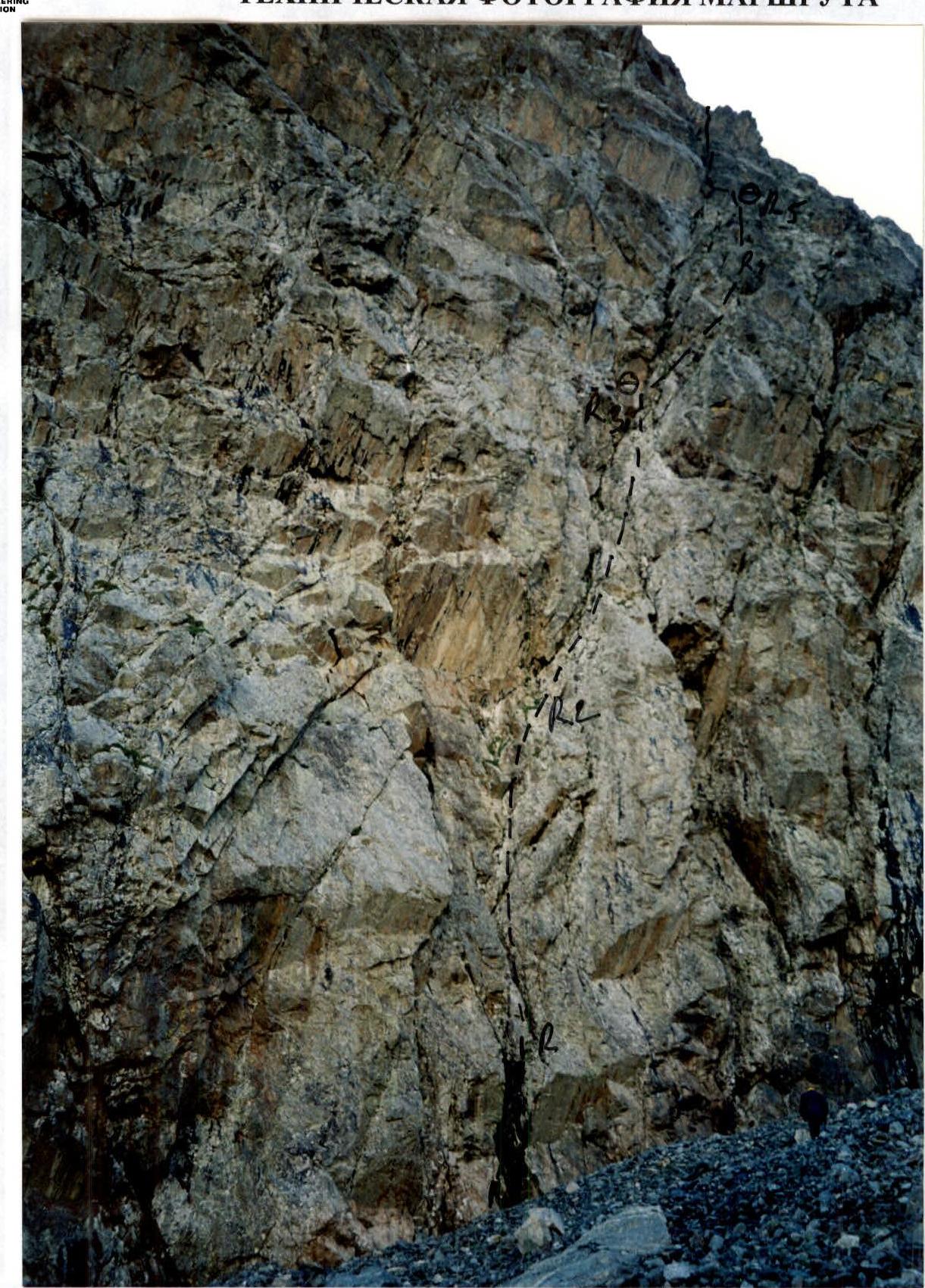
Photo 1a
The photo is taken from the moraine pocket at the start of the route. The lower part of the route (sections R0–R5) is visible.
Summary Table of Route Sections
| Section Number | Length, m | Steepness, ° | Category of Difficulty | Rock Pitons | Chocks | Friends | Ice Screws | Time Taken, min | Description of the Route Section |
|---|---|---|---|---|---|---|---|---|---|
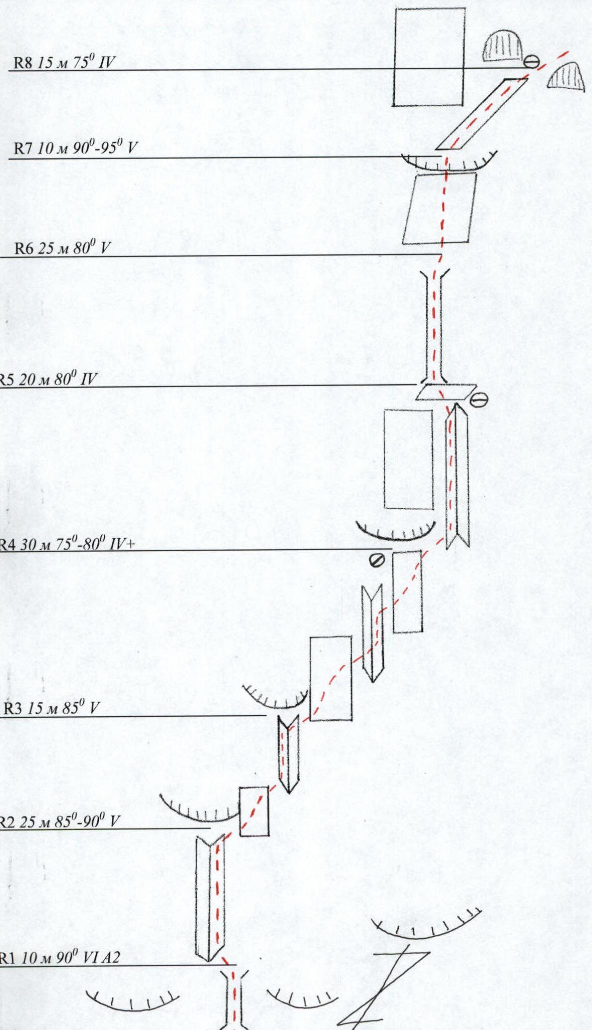
| R0–R1 | 10 | 90 | 6 | 2 / 2 | 4 / 1 | 2 | 30 | Overhanging chimney, ITO. | |
| R1–R2 | 25 | 85–90 | 5 | 2 | 3 | 2 | 45 | Wide internal angle, resting on a cornice. | |
| R2–R3 | 15 | 85 | 6 | 3 | 1 | 3 | 30 | Bypassing the cornice on the right and along the internal angle to the second cornice | |
| R3–R4 | 30 | 75–80 | 4 | 3 | 3 | 2 | 35 | Bypassing the cornice on the right and along the walls and internal angle to a rock rib. | |
| R4–R5 | 20 | 80 | 4 | 5 | 2 | 0 | 30 | Along the rib to a small shelf. | |
| R5–R6 | 25 | 80 | 5 | 2 | 2 | 3 | 45 | Steep chimney | |
| R6–R7 | 10 | 90–95 | 5 | 3 | 1 | 0 | 20 | Rock wall with an overhang at the top | |
| R7–R8 | 15 | 75 | 4 | 0 | 3 | 2 | 20 | Inclined shelf-gutter | |
| R8–R9 | 70 | 25 | 2–3 | 2 | 0 | 0 | 10 | Grassy shelf | |
| R9–R10 | 50 | 80 | 4 | 4 | 2 | 3 | 65 | Rock wall leading to a large flake. Loose rocks. | |
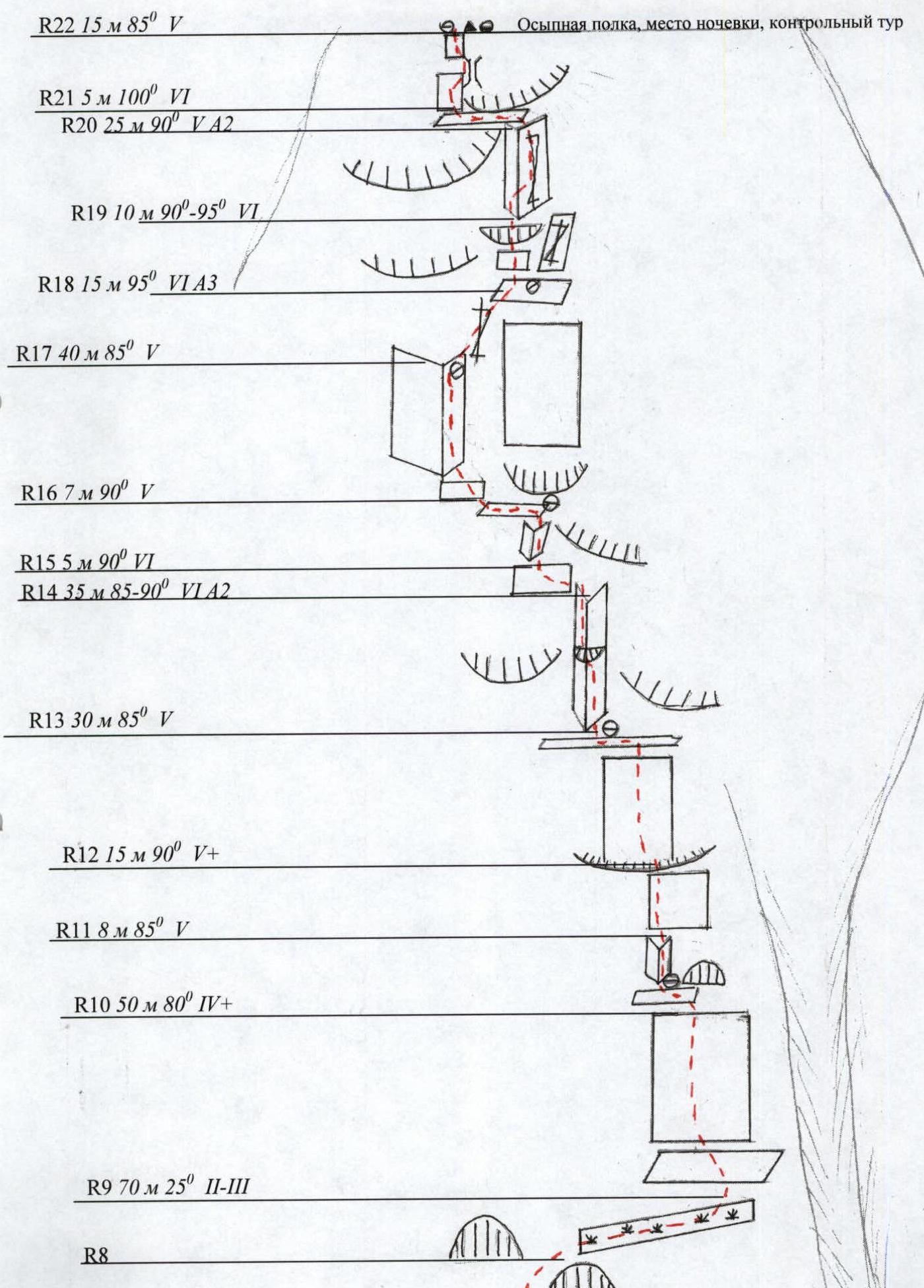
| R10–R11 | 8 | 85 | 5 | 0 | 2 | 1 | 20 | Internal angle. | |
| R11–R12 | 15 | 90 | 5 | 1 | 1 | 3 | 25 | Wall with a 2-meter overhang at the top | |
| R12–R13 | 30 | 85 | 5 | 1 | 2 | 1 | 50 | Wall with few holds, leads to a narrow transverse crack. | |
| R13–R14 | 35 | 85–95 | 6 | 2 / 2 | 4 / 3 | 3 / 1 | 60 | Steep chimney with an overhang in the middle. ITO, key section | |
| R14–R15 | 5 | 90 | 6 | 1 | 0 | 0 | 10 | Traverse left under the cornice. Very small holds. | |
| R15–R16 | 7 | 90 | 5 | 1 | 1 | 2 | 15 | Internal angle. | |
| R16–R17 | 40 | 85 | 5 | 2 | 3 | 2 | 50 | Wall turning into an internal angle. Gentle holds | |
| R17–R18 | 15 | 95 | 6 | 3 | 2 / 2 | 2 / 2 | 40 | Negative wall with a wet crack. ITO. | |
| R18–R19 | 10 | 90–95 | 5 | 0 | 2 | 1 | 30 | Wall with an overhang at the top. Loose rocks. | |
| R19–R20 | 25 | 90 | 5 | 2 / 2 | 4 / 2 | 5 | 50 | Internal angle with a crack on the right. ITO. | |
| R20–R21 | 5 | 100 | 6 | 0 | 1 | 0 | 15 | Traverse along the overhang to the right. There is a ledge "behind the corner" but it's not visible. | |
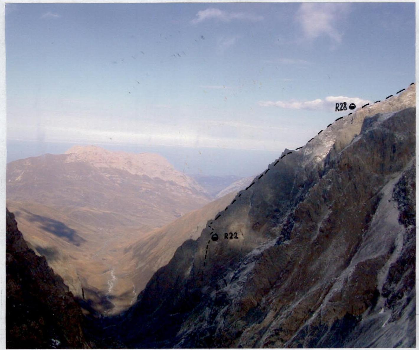
| R21–R22 | 15 | 85 | 5 | 2 | 0 | 2 | 30 | Exit to a large scree shelf. Control tour. Overnight stop. | |
| R22–R23 | 100 | 70 | 4 | 6 | 2 | 3 | 90 | System of rock angles and shelves. | |
| R23–R24 | 100 | 70 | 3 | 2 | 3 | 3 | 60 | Rock ridge | |
| R24–R25 | 50 | 70 | 4 | 1 | 3 | 2 | 60 | Rock slab-wall. Slippery, mossy. | |
| R25–R26 | 150 | 65 | 4 | 6 | 4 | 8 | 100 | Rock ridge with small pinnacles. Overcome directly. | |
| R26–R27 | 100 | 25 | 1–2 | 0 | 0 | 0 | 10 | Scree shelf | |
| R27–R28 | 200 | 60–65 | 3 | 4 | 6 | 6 | 120 | Rock ridge consisting of large blocks. Leads to a shelf. Overnight stop. | |
| R28–R29 | 150 | 60 | 4 | 3 | 8 | 3 | 120 | Destroyed ridge leading to the confluence of several buttresses. | |
| R29–R30 | 250 | 30 | 3 | 3 | 2 | 120 | Gentle, destroyed ridge. | ||
| R30–R31 | 150 | 55 | 3 | 2 | 2 | 90 | Rock ridge abutting an ice dome. | ||
| R31–R32 | 120 | 55 | 4 | 8 | 80 | Ice slope. | |||
| R32–R33 | 70 | 60 | 4 | 5 | 60 | Traverse towards the western ridge | |||
| R33–R34 | 100 | 45 | 2–3 | 30 | Simple summit ridge. |
Route Diagram
Route Diagram in UIAA Symbols (Section R0–R8)
Route Diagram in UIAA Symbols (Section R8–R22)
Route Description
The route begins with a clearly defined internal angle blocked by a large yellow cornice. The first part of the route (150 m) passes through a crack going steeply upwards from left to right. The first 10 m is a chimney with an overhanging top, dripping with water. Climbed on ITO. Then 25 m steeply up to the base of the cornice and to the right along a steep wall with a few holds along the junction of the cornice and the wall. Further, to the right and upwards, into an internal angle under an overhang. Here is a station (a left piton). From the station, to the right and upwards along the wall, crossing a small internal angle, ascend to a steep slab, along which, along the cornice, exit to a rock ridge. Along the ridge, straight up to a small shelf at the right side of the base of a 30-meter chimney. Station — a left piton. Along the chimney, exit to a small shelf under an overhang. The overhang is overcome directly from the right side. With wet rocks — ITO. Further, 15 m along an oblique shelf to two rock ledges. A convenient station under the upper ledge. From the station, 70 m to the right along a simple oblique shelf towards a chimney behind a pinnacle. Do not enter the chimney — it is stone-dangerous. 10 m before the chimney, ascend along a destroyed wall towards a large flake. Under the flake is a station. Bypassing the flake on the left, enter a smoothed internal angle. In case of bad weather — ITO. From the internal angle, exit to a steep wall and along it 15 m to a small overhang, which is overcome on the left side. Then 30 m along an inclined smoothed wall to a horizontal shelf-crack. Station. From the station, to the left, enter a steep 35-meter internal angle with an overhang in the middle. Key section — ITO. At the top of the angle, exit under a cornice, which is bypassed on the left along a wall with very small holds (difficult climbing). Further, along a 7-meter internal angle, exit under a large overhang. Here, on a shelf, is a station. To the left and upwards, exit to an inclined slab-wall, turning into an internal angle. Along the internal angle, ascend to a crack on the right overhanging wall. At the base of the crack is an inconvenient station. Along the crack, to the right and upwards, 15 m to an inclined slab. ITO, ladders. It is recommended to make a station on the slab since further insurance from the lower station is problematic. Further, along a wall with an overhang at the top, ascend to the base of a wide destroyed internal angle. Along the right side of the angle, along a crack, ascend under a large overhang. ITO. Loose rocks. Under the overhang, traverse to the left along a gentle shelf. Behind the "corner" is a good ledge, which is not visible. Further, along a wall, and then along an internal angle, ascend to a large scree horizontal shelf. Control tour. Overnight stop.
From the shelf, in the middle part, upwards, and then to the right and upwards along a system of rock walls and shelves, exit to the ridge of the buttress. Along the ridge, ascend to a rock wall-slab, overcoming which, exit to a depression. Bypassing the elevation of the ridge on the left along a shelf, approach under a steep rock ascent. Overcoming the ascent, pass along the ridge to a large scree field. It is possible to bypass the ascent on the right through a gap between the ridge and a large pinnacle. Further, from the gap, ascend to the scree field along a steep couloir with flowing water. Slippery, stone-dangerous. From the scree field, ascend along a rock, large-block ridge to the exit to the northern ridge (3700 m mark). Overnight stop.
Further:
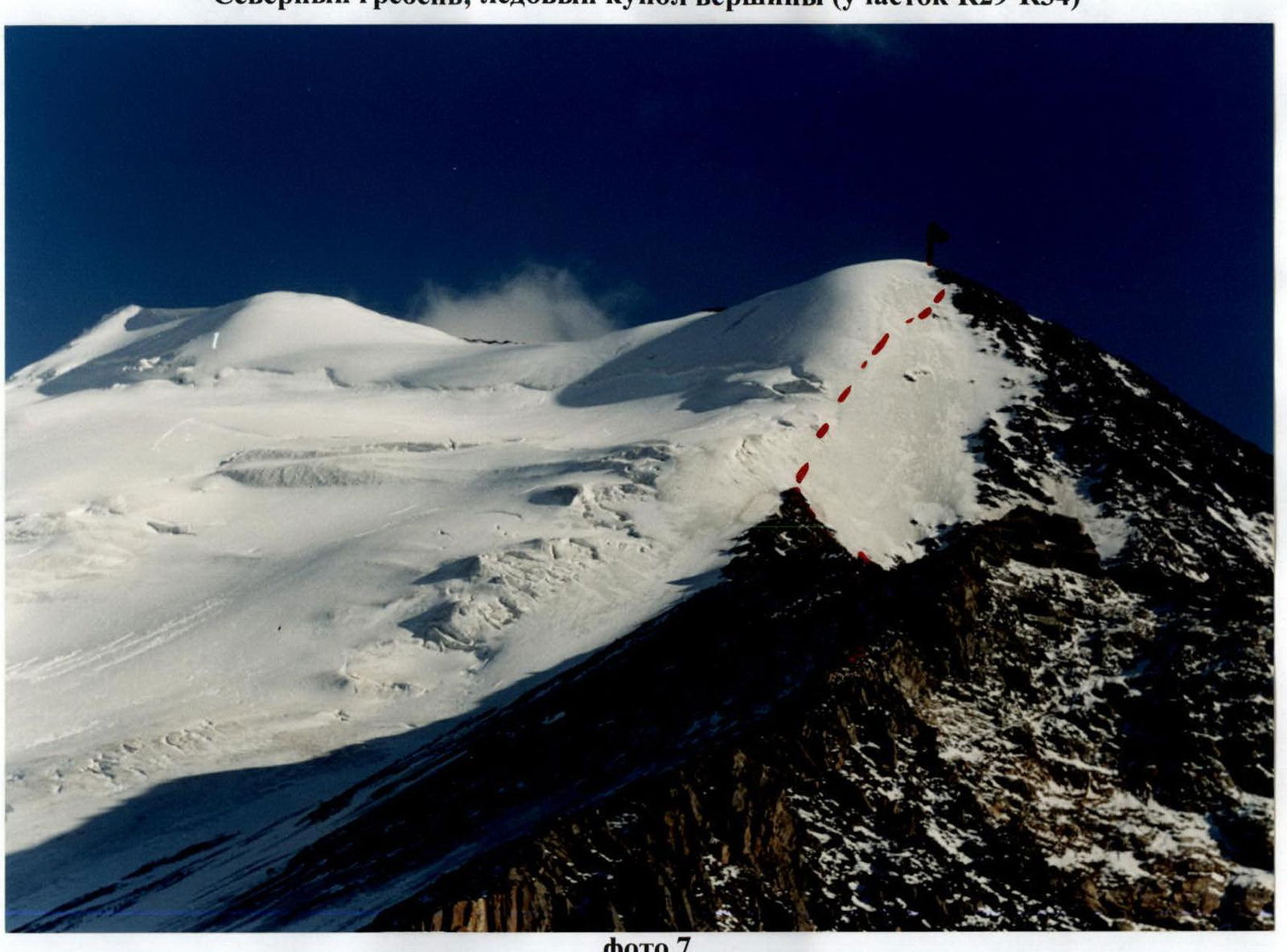
- Along a gentle rock ridge, move towards the ice dome of the summit.
- Along the ice slope (hard ice), ascend to the upper rock outcrops. Insurance, ice screws.
- Along the ice — a difficult traverse to the right and exit to the summit rock ridge.
- Along a simple ridge, ascend to the summit. Descent to the south towards the Midagrabin glacier along route 1B. From the summit to the base camp — 3 hours.
Preparation for the Ascent
During an overflight of the Midagrabin glacier area in autumn 2001, photographs were taken of the western wall of the peak Zeygalan. The western wall rises with steep buttresses from the narrow gorge of the Midagrabin-Don River. In winter 2001, a reconnaissance exit was made to the base of the buttresses. The left buttress was chosen for the route. In winter 2002, an attempt was made to climb this route, but abundant snowfall and strong southern winds prevented this. The ascent was postponed to the summer period of 2003. In August 2003, a reconnaissance of the route was carried out, and it was adjusted for the summer period, and some equipment was cached under the start of the route. During this trip, on August 25, an ascent was made to the peak Zeygalan via the Western Ridge (approximately 2B) to scout out the descent and view possible overnight stops on the western wall. A path was planned along the ice dome from the northern ridge to the summit.
Team's Tactical Actions
Based on the materials obtained during the route reconnaissance, the team developed the following tactical plan:
- Process the lower part of the route with the aim of reaching the next day the shelf planned for overnight stops (3360 m). It was planned to process approximately 300 m of the wall.
- On the next day, the leading rope team continues to fix ropes to the shelf, while the second rope team removes the ropes fixed on the first day and throws them to the observers. The group spends the night on the shelf.
- On the third day, ascend to the end of the northern ridge.
- On the fourth day — reach the summit.
During the ascent, the tactical plan was almost fully executed. A deviation occurred on the second day of the ascent due to the lack of water on the shelf and along the entire ridge. The group had to descend into a gap and along shelves descend into a couloir for water (on the route diagram, section R24–R25*). This deviation did not affect the accomplishment of the set tasks and the safety of the ascent.
Supplements
- The report includes photographs from different seasons: autumn 2001, winter 2002, summer 2003, and directly from the ascent.
- The ascent is best done in August–September when snow patches over the cornices melt, and the route is dry.
- A large number of rock sections are mossy, and in wet weather, their difficulty greatly increases.
- During the ascent, a note was retrieved from the peak 8 Marta.
- It is necessary to bring a sufficient amount of water for the first overnight stop, calculated for the entire next day.
- It is necessary to obtain permission to stay in the border zone.
- The climbing area is rarely visited. There is no stable radio communication with Vladikavkaz. A observation group is necessary.
Photograph of the Start of the Route (Section R0–R2)
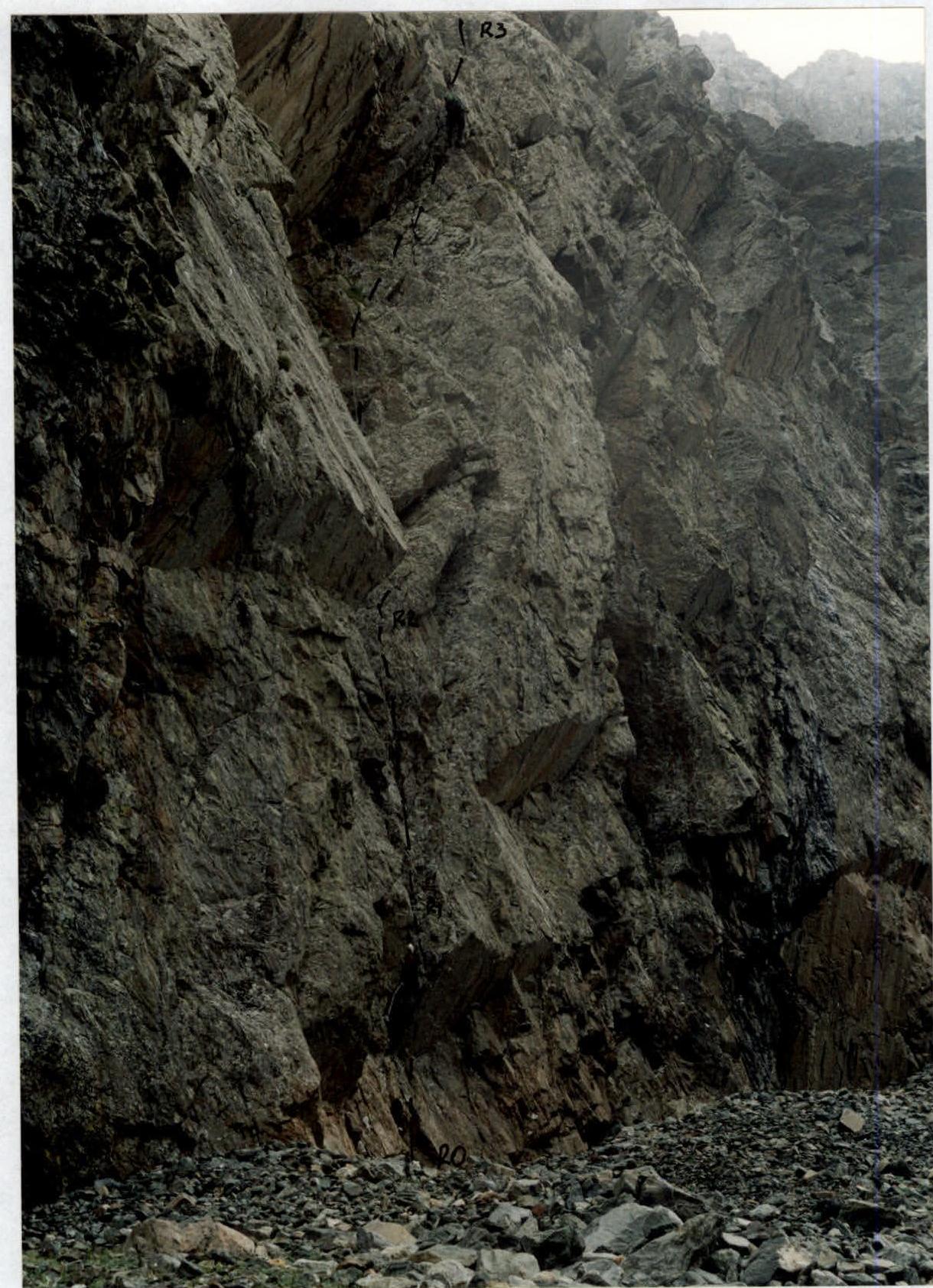
Photo 2. Photograph of the Key Section of the Route (Section R13–R16)
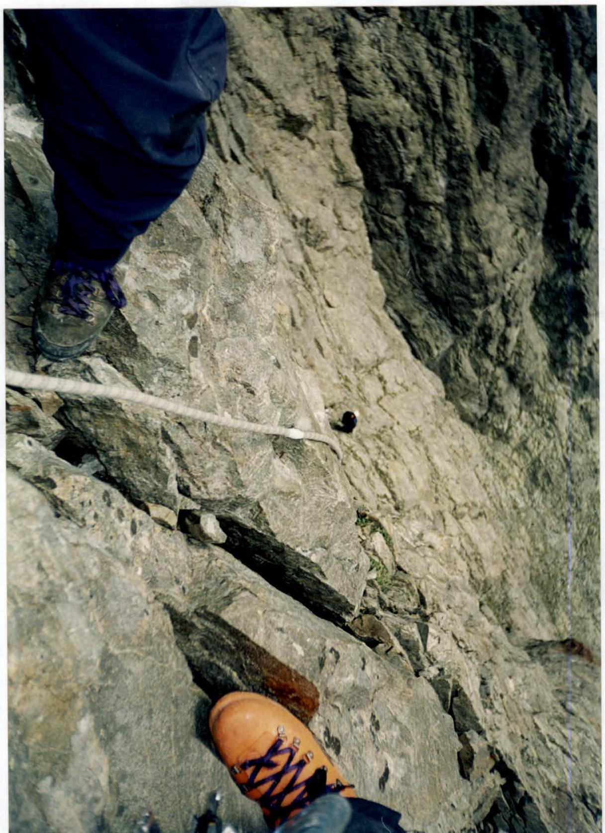
Photo 3. Steep Internal Angle (Section R16–R17)
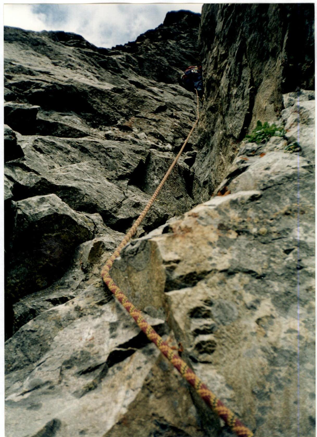
Photo 4
Summit and Upper Part of the Northern Ridge
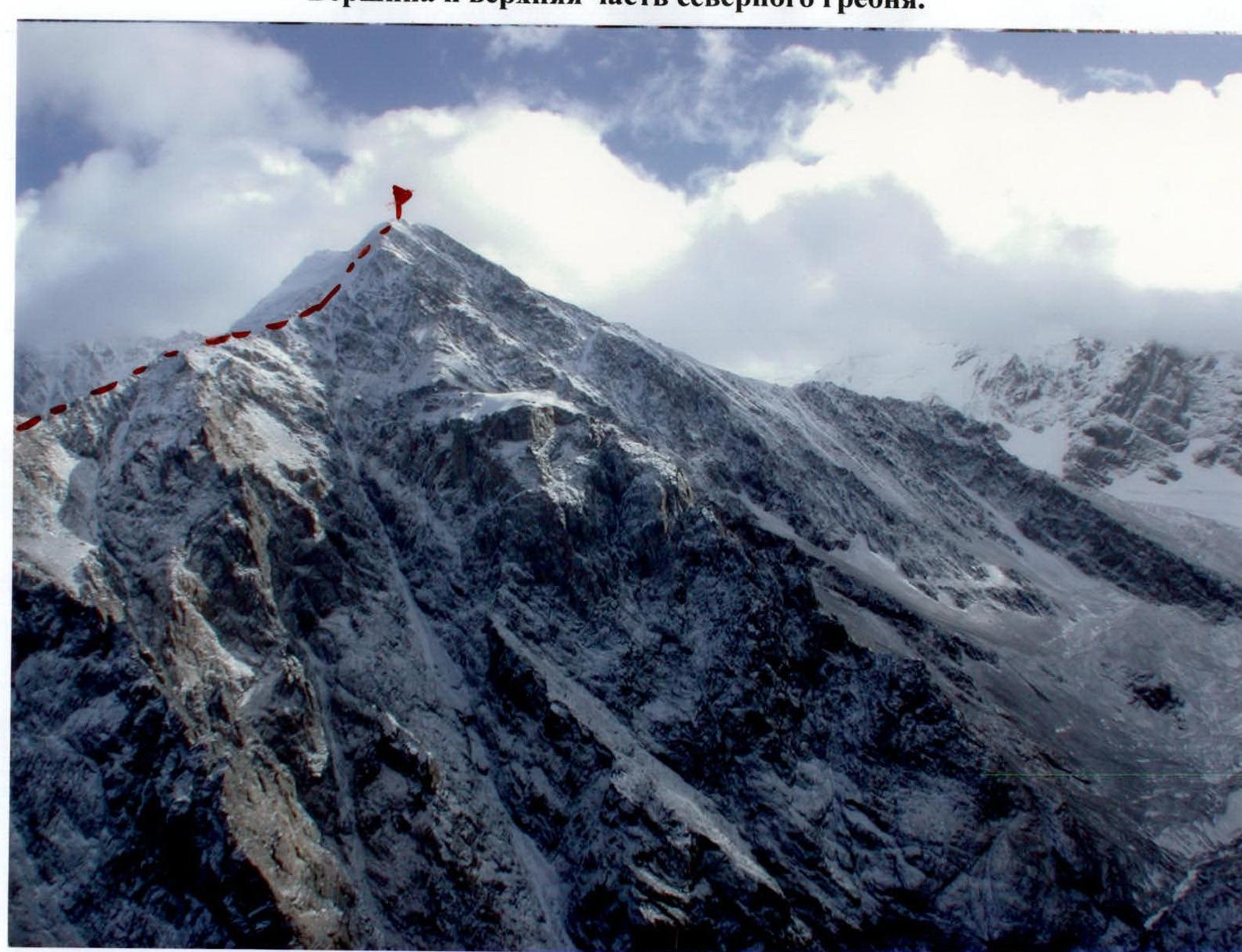
Photo 6. Northern Ridge; Ice Dome of the Summit (Section R29–R34)