
ROUTE DESCRIPTION
Traverse of the peaks Dzhimaraikhokh (4778 m) — "4398" — Suatisi-Khokh (4473 m) 5A cat. diff.
The peaks Dzhimaraikhokh (4778 m), "4398" and Suatisi-Khokh (4473 m) are located in the Lateral Range of the Caucasus, west of the peak Kazbek. Their massifs limit the Midagrabin plateau from the east and southeast.
Dzhimaraikhokh is the highest peak in the mountains of North Ossetia. The ice masses of Dzhimaraikhokh and Suatisi-Khokh are connected by a ridge. The peaks Dzhimaraikhokh, "4398" and Suatisi-Khokh:
- are composed of schists cut through by diabase dykes;
- have significant glaciation.
The western rock-ice rib of Dzhimaray steeply descends into the upper cirque of the Midagrabin glacier.
The first ascent on Dzhimaraikhokh was made via the eastern ridge by a group led by A. Dzaparidze in 1935.
The traverse of the peaks Dzhimaraikhokh — Shau-Khokh is classified as 4A cat. diff.
The ascent to Dzhimaraikhokh was made via the western rib from the Midagrabin glacier (corresponds to 4A cat. diff.).
The peak Suatisi-Khokh was first ascended in 1956 via the western ridge from the Tep pass by a group of "Lokomotiv" led by Yu. Polyakov (the route remained unclassified).
The traverse Dzhimaraikhokh — "4398" — Suatisi-Khokh was first passed in September 1958 by a group of "Lokomotiv" led by L. Tsybkin.
Day 1
The starting point for the ascent is the city of Ordzhonikidze, from where you should follow the road through the villages: Gizel, Dargavs, Dzhimara to the ruins of the geologists' settlement in the upper reaches of the Gizeldon river (87 km above the village of Dzhimara). The journey takes 2.5 hours. The first bivouac is set up at the site of the former geologists' settlement.
Day 2
On this day, you need to go from the geologists' settlement through the tongue of the Midagrabin glacier to its upper reaches and ascend to the bivouac site at the base of the western ridge of Dzhimaraikhokh. The ascent on this day is about a kilometer.
From the geologists' settlement, you need to move along a once well-trodden path, which winds steeply up the right (orogr.) bank. High above the river floodplain, the path:
- crosses several gullies;
- leads to grandiose "sheep's foreheads", through which a pack trail is cut (road).
1.5–2 hours after leaving the bivouac, bypassing the "sheep's foreheads", the path leads to a scree slope, where it disappears.
From here, the tongue of the Midagrabin glacier is clearly visible in front (half a kilometer away), which can be reached by going down the same slope with step-cutting (when exiting onto the glacier tongue) or, even simpler, by crossing to the opposite side of the river, ascending 100 m up the scree, traversing the scree slopes and exiting onto the left-bank moraine of the glacier, which soon leads to its surface. The glacier is calm and safe here. You need to move along the glacier until it turns east and, following the turn, stick to the median moraine of the glacier — in the eastern direction of the upper reaches. The western rib of Dzhimaraikhokh serves as a landmark. When level with the peak Midagrabin-Khokh, you need to rope up, as the glacier is heavily crevassed here. The scree at the base of the rib and the snowy slopes lead 400 m up to the line of the rib, behind a huge rock "finger", where a platform for the night is laid out. The 2nd bivouac is set up here.
The transition from the glacier tongue to the bivouac site takes more than 4 hours of walking.
Day 3
The exit from the bivouac is early (for the day ahead, you need to traverse the rib, ascend to the summit, and set up a bivouac in a hollow at the junction of the northern ridge and western rib). They go first along the scree, small and sliding underfoot, along the ridge, to the right of the path (300 m). The steepness of the scree reaches 40°. Having passed along the scree to the snow, they turn left and ascend the ice couloir with boulders frozen into its bed, 25 m long and 45–50° steep, onto the ridge with alternating belays.
Further, the path passes along the ridge, which is a destroyed moderate-difficulty rock terrain interspersed with ice and snow sections.
- The steepness of the rocks in some places reaches 60–70°;
- The steepness of the ice and snow sections is up to 45°.
On the rocks and ice, alternating belays are mandatory; the ice is traversed on crampons. They follow the ridge, bypassing small "gendarmeries" as necessary (to the right and left).
Finally, having overcome a steep (45°) ice section (the ice is covered with a thin layer of snow) up to 100 m long, they approach the base of the first rock wall. The ice section is traversed on crampons with piton belays (1 ice screw and 1 rock piton).
The 1st rock wall is about 110 m long, with a steepness of up to 60°. It is overcome with belays using rock pitons (two pitons are hammered in).
Then they approach the second rock wall. It is steeper, with a height of up to 150 m. A narrow crest 5–7 m long leads from the first rock wall to the second. The path along the second rock wall goes straight up. Having hammered in four rock pitons and ascended the wall, they exit onto the ridge of Dzhimaraikhokh (to the left of the summit).
On the ridge, there is a wide ice hollow protected:
- from the west — by rocks;
- from the east and north — by snow and ice drifts.
Having cut out a platform in the ice, the third bivouac is organized. Traversing the rib of Dzhimaray from the lower bivouac to the hollow takes approximately 9–10 hours of work.
Day 4
From the night's halt, the path goes along the snow and ice ridge with cornices to the east, dropping steeply to the west. On the ridge, there are two ice walls. One wall is 15 m high, 60° steep, the other is 50° steep, 10 m high. Having overcome these walls with alternating belays on the front points of crampons and with step-cutting, they exit onto a wide ridge, which leads to the summit. You need to proceed along the ridge carefully, wary of the huge cornice overhanging from the summit ridge to the western side. The path from the night's halt to the summit takes 1.5 hours.
The descent from the summit in the direction of Suatisi-Khokh is organized along the snow and ice ridge, 40° steep, straight down to the rocky outcrops, and then along them again downwards. The slope is icy. You need to proceed on crampons with alternating piton belays (5 ice screws). The total length of the descent is about 500 m. Further, there is a gentle icy ridge with small changes in elevation. The ridge has cornices to the east, dropping steeply to the west with an icy slope. After 300 m, the ridge becomes sharp and dangerous, requiring careful belays. In some places, you have to "ride astride" the ridge. "Gendarmeries" on the ridge are overcome "head-on". Having passed this rocky ridge, about 200 m long, they exit onto a sharp snow and ice crest with small changes in elevation, about 400 m long, which leads to a nodal unnamed summit. The ridge is unpleasant, sharp, with cornices sometimes to the west, sometimes to the east. You need to proceed, stepping back 0.5–1 m from the edge along the steep bend of the icy slope, which becomes even steeper further down. From the unnamed summit, a sharp ridge branches off towards the peak "4398" with small cornices. This crest is traversed in 40 minutes. The peak "4398" is composed of destroyed schistose rocks. From it, a rocky ridge stretches to the east. From the peak "4398", they return along the ascent path to the unnamed summit, and from there, down the ice-firn slope with piton belays (2 ice screws) to the saddle between the peaks Suatisi-Khokh and the Unnamed one. This descent is about 400 m long, 35–40° steep. On the rocky outcrops, the 4th bivouac is organized. The entire path takes 9 hours.
Day 5
From the bivouac, the ascent to the peak Suatisi-Khokh passes along an icy ridge, 30–40° steep. You need to proceed on crampons. The ridge drops steeply to the northwest onto the Midagrabin glacier with huge cornices and rockfall, and to the northeast — with a steep icy slope onto the Suatisi glacier. The ridge is broken in its middle part by several crevasses of small width, making movement difficult. In two places, there are small ice "foreheads" 40° steep with a smooth surface. They are traversed with belays. The snow and ice ridge with cornices stretches from north to south and leads to the peak Suatisi-Khokh, representing a firn ridge. The cairn is located below the summit to the south, on destroyed rocks. To approach it, you need to cross a crevasse 0.5 m wide.
The descent from the summit passes along the northwest ridge, which drops steeply to the north with cornices and rockfall. For 200 m, the descent along the firn ridge is 25° steep. In several places, the path is obstructed by narrow crevasses.
Then the steepness of the slope increases to 55°. This icy slope, about 200 m long, is traversed with piton belays and step-cutting (six ice screws are hammered in).
Then the ice gradually gives way to firn, and the ridge becomes gentler, 30° steep. They descend along it for another 150 m and then, having crossed a wide crevasse (1 m wide), exit onto the Tep pass.
The traverse of the peak Suatisi-Khokh from the 4th night's halt to the Tep pass takes 7 hours.
The descent from the Tep pass onto the Midagrabin glacier passes first along very steep, heavily destroyed schistose rocks 70 m straight down from the cairn on the pass, and then on crampons down steep icy firn and ice (2 ice screws are hammered in) down to the left to the bergschrund. Having crossed the bergschrund, they exit onto a horizontal terrace of the glacier, and then, descending onto the Midagrabin glacier plateau, they need to overcome a heavily crevassed icefall 45° steep, turn left, and, overcoming several wide crevasses (up to 1.5 m wide) along the way, descend onto the Midagrabin glacier.
Movement along the glacier:
- initially in roped parties;
- when level with the peak Midagrabin-Khokh, you can unrope;
- further movement down the glacier through the "sheep's foreheads" to the ruins of the geologists' settlement.
From here, by car, in 2.0–2.5 hours, you can return to the city of Ordzhonikidze.
Route assessment. Taking into account the technical difficulties of the traverse of the peaks Dzhimaraikhokh — Suatisi-Khokh with an elevation difference of the ridge of more than a kilometer, the route should be classified as 5A cat. diff.
Description compiled by: R. Proskuryakov.
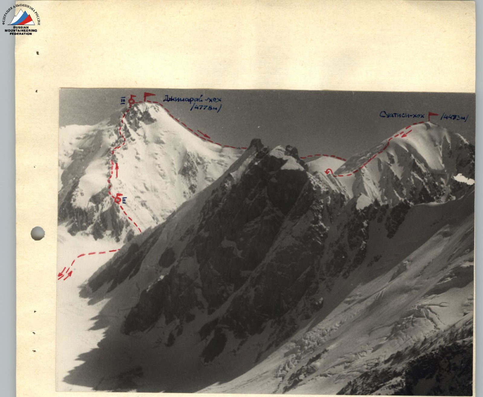 Massifs of Dzhimaraikhokh and Suatisi. View from the west. Photo by R. Proskuryakov.
Map-scheme of the ascent to Dzhimaraikhokh (4778 m) — Peak "4398" — Suatisi-Khokh (4473 m). Route of the group: Bivouacs:
Massifs of Dzhimaraikhokh and Suatisi. View from the west. Photo by R. Proskuryakov.
Map-scheme of the ascent to Dzhimaraikhokh (4778 m) — Peak "4398" — Suatisi-Khokh (4473 m). Route of the group: Bivouacs:

Comments
Sign in to leave a comment