Ascents on Jimarai-khokh (4778 m) via the western edge 4A–4B cat. diff.
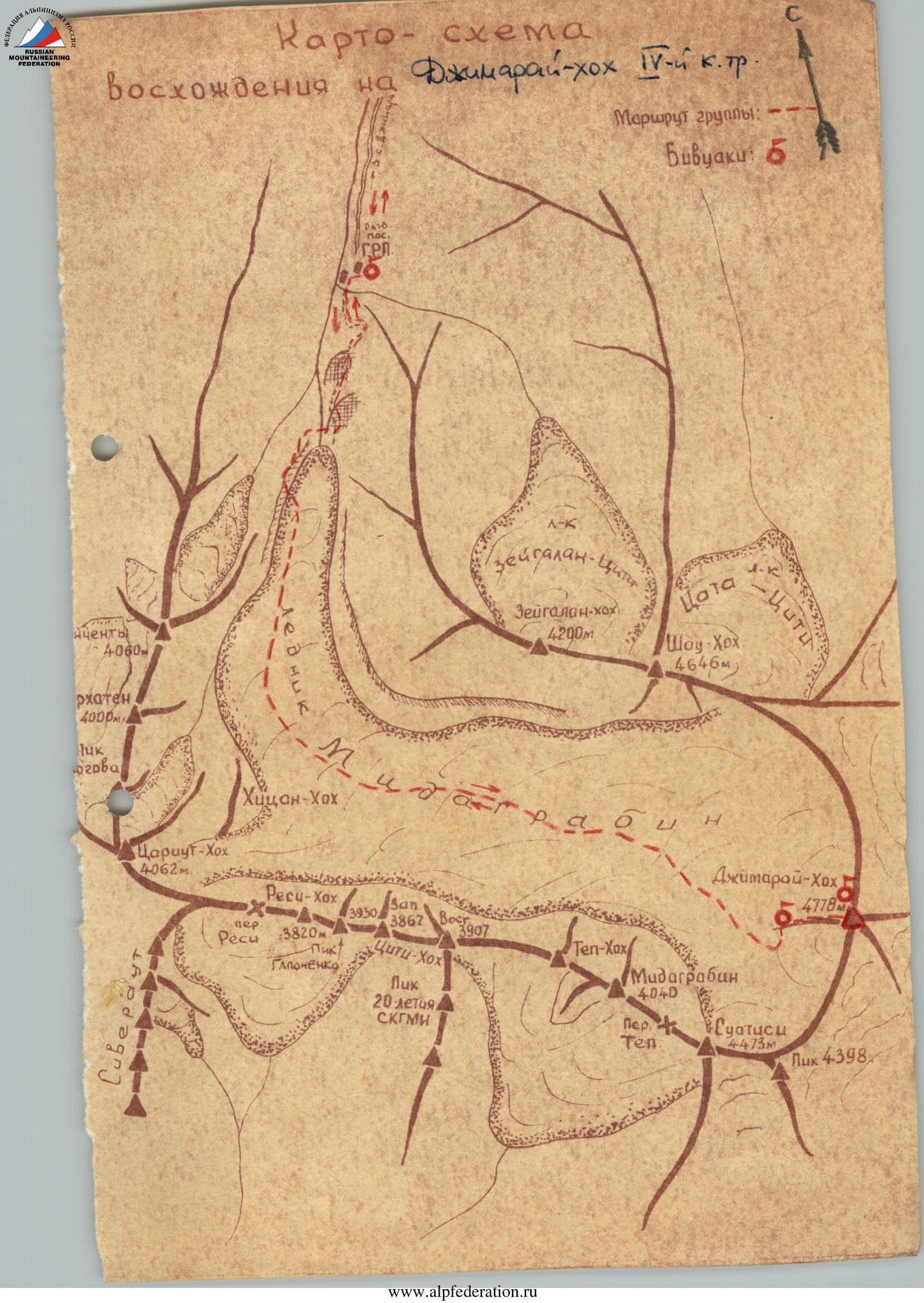
The Midagrabin Glacier area is adjacent to the Kazbek high-altitude area to the west and is located in the eastern part of the Central Caucasus. The highest peak in the area and North Ossetia - Jimarai-khokh - is located in the upper reaches of the Midagrabin Glacier. Jimarai-khokh, being a nodal peak of the forward ridge, is connected:
- by the eastern ridge - with Maili-khokh (4602 m),
- by the northern ridge - with Shau-khokh (4646 m),
- by the southern ridge - with Suatisi-khokh (4453 m).
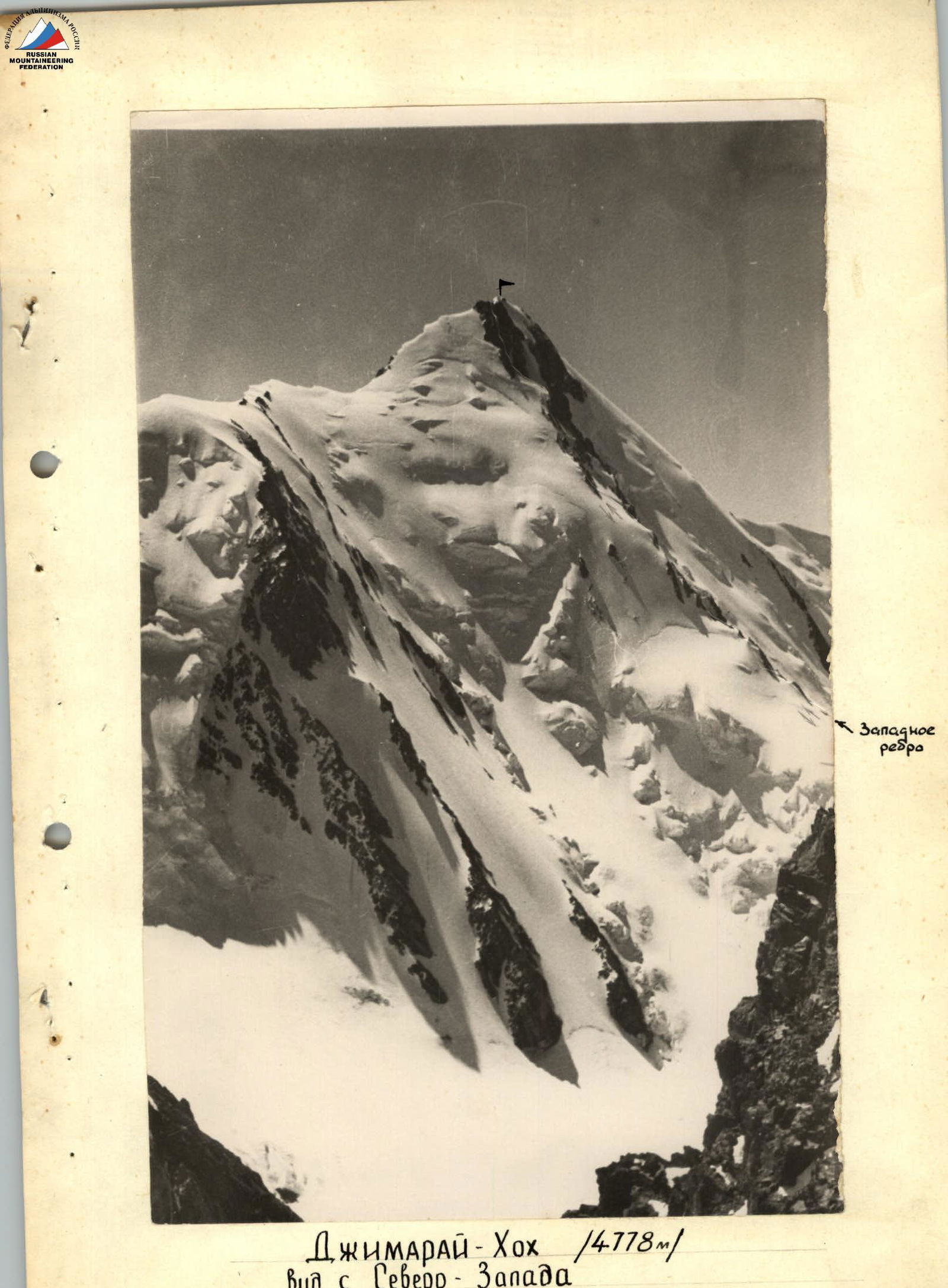
The steep ice-rock western edge descends onto the Midagrabin Glacier.
For the first time, the western edge of Jimarai-khokh was climbed by a group of North Ossetian climbers led by I. Suzhaev in 1955. In 1958, a group of climbers from the "Lokomotiv" sports society led by L. Tsybin made a second ascent of the route. All participants of both groups were 1st class climbers and Candidate Masters of Sports.
Day I. The starting point for the ascent is the city of Ordzhonikidze, from where they follow the road through the villages:
- Gizel,
- Dargavs,
- Jimara
to the ruins of a geologists' settlement in the upper reaches of the Gizeldon River, 7 km above the village of Jimara. The journey takes 2 hours 30 minutes. The first bivouac is set up at the site of the former geologists' settlement.
Day II. On this day, it is necessary to:
- Pass from the settlement through the tongue of the Midagrabin Glacier to its upper reaches.
- Ascend to the bivouac site at the base of the western edge of Jimarai-khokh.
The altitude gain on this day is about 1 km.
From the geologists' settlement, you need to move along a once well-trodden path, which steeply winds up the right (orographic) bank. High above the river floodplain, the path crosses several gullies and leads to the grandiose "sheep's foreheads", where a pack road is laid. 1.5-2 hours after leaving the bivouac, bypassing the "sheep's foreheads", the path leads to a scree slope, where it disappears.
From here, the tongue of the Midagrabin Glacier is clearly visible half a kilometer ahead, which can be reached:
- by this same slope with step-cutting, or
- more simply, by crossing to the opposite bank of the river, ascending 100 m up the scree, traversing the scree slopes, and reaching the left-bank moraine of the glacier, which will soon lead to its surface.
The glacier is calm and safe here. You need to move along the glacier until it turns east, and, following its bend, sticking to the middle moraine of the glacier, - in the eastern direction, to the upper reaches. The transition from the tongue to the Jimarai-khokh massif will take about 3 hours.
The western edge of Jimarai serves as a landmark. When level with the peak of Midagrabin-khokh on the glacier, it is necessary to rope up, as the glacier is heavily dissected here.
The scree at the base of the edge and snow slopes lead up 400 m to the line of the edge, behind a huge rock "finger", where a platform for an overnight stay is laid out. The second bivouac is set up here.
Day III. The exit from the bivouac is early. For the day, it is planned to traverse the edge, ascend to the summit, and organize a bivouac in a hollow at the junction of the northern ridge and the western edge.
For 300 m upwards, you go along a 40° scree, and then a snowy slope to the right of the edge line. Turning left, you ascend to the edge line along an ice gully with boulders frozen into its bed; its length is 25 m, steepness is 40-45°; the gully is traversed with alternate belay.
Further, the path passes along the edge, composed of destroyed, moderately difficult rocks of effusive origin, interspersed with ice-snow ascents. The steepness of the rocks reaches 70° in places, and that of the ice ascents - 50°. On rocks and ice, alternate belay is mandatory; ice sections are traversed in crampons. They move mainly along the edge line, occasionally bypassing small "gendarmeries" both to the left and to the right. Having overcome a steep - from 45° to 55° - ice ascent up to 100 m long (the ice is covered with a very thin layer of snow!), you reach the base of the first rock wall. The ice section is traversed in crampons with piton (rock and ice) belay.
The first rock wall, about 100 m high and up to 60° steep, is overcome "head-on" with piton belay (3-4 pitons). There are many "live" stones on the wall, and the rocks are unreliable. Along a narrow snowy ridge 7 m long, you reach the base of the second rock wall, steeper and higher (about 150 m). The wall should be overcome by moving straight up. Belay is with pitons; the rocks are quite difficult.
Having passed the wall, you reach a snow-ice hollow at the junction of Jimarai's northern ridge and its western edge. The hollow is wide and protected from the wind
- from the west and south - by rocks,
- from the east and north - by snow drifts.
Here, it makes sense to organize a third bivouac, cutting out a platform in the ice. Traversing the edge from the second bivouac to the hollow will take about 8-9 hours.
On the same day, you can ascend to the summit and return to the third bivouac. The route is along the ridge, to the south, following the ascents of the grandiose northern ridge of the peak. To the east, the massif forms a two-kilometer wall, and to the west - walls and steep ice slopes onto the Midagrabin Glacier. Huge cornices hanging to the east require caution from the climbers! Two ascents of the ridge are ice walls, the first - 15 m high and 60° steep, the second - 10 m high and 50° steep. Having overcome the walls on the front points of the crampons with alternate belay (step-cutting is possible), you reach a wide, snow-ice ridge leading to the summit. From the bivouac to the summit is about 1.5 hours' work.
From the summit of Jimarai-khokh, which is second to none in height (except for Kazbek), a stunning panorama of the Eastern and Central Caucasus opens up to the peaks of the Bezengi region.
The descent from the summit completely coincides with the ascent route, both to the third bivouac and along the western edge onto the Midagrabin Glacier.
Day IV. The descent from the third bivouac to the glacier takes 6 hours. Further, by a familiar route, the group descends on the same day through the "sheep's foreheads" to the ruins of the geologists' settlement (2 hours 30 minutes - 3 hours), from where a car can return to Ordzhonikidze in 2 hours 30 minutes.
The complex and interesting route along the ice-rock western edge to the highest peak in North Ossetia - Jimarai-khokh (4778 m) with an altitude difference of more than a kilometer should be classified as 4A-4B category of difficulty.
The description was compiled by R. Proskuryakov 
Equipment recommended for a group of 4 people: Not more than 6 people
- Ropes - 2 pcs. × 40 m
- Rock pitons - 10 pcs.
- Ice pitons - 3 pcs.
- Crampons - 4 pairs
- Carabiners - 8 pcs.